Observations

01/30/21

Walrod

Date of Observation: 01/30/2021
Name: Daniel K

Zone: Southeast Mountains
Location: Walrod gulch
Aspect: East
Elevation: 9400

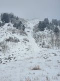
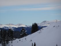
Avalanches: Noticed a small skier triggered slide in the path just past the walrod connector that looks like it went yesterday. Couldnt really distinguish a crown with the ski tracks and low vis and could’ve been a point release entraining snow in the gully. Not enough snow to go all the way to the road.


Photos:

Read Full Observation
01/30/21

Gothic 7 a.m.

Date of Observation: 01/30/2021
Name: billy barr

Zone: Southeast Mountains
Location: Gothic

Weather: Cloudy with steady and light, but dense, snow much of the night with 2″ new and water 0.20″- a small crystal compact snow. Snowpack sits at 34″. Currently it is cloudy but not snowing and staying generally mild with the low and current temperature at 18ºF after a high yesterday of 37F (and 39 the day before). Wind is light with occasional gusting from the west. Little by little the snowpack goes….nowhere. billy


Read Full Observation
01/30/21

Cement Creek

Date of Observation: 01/30/2021
Name: Cosmo Langsfeld


Zone: Southeast Mountains
Location: Cement Creek Ranch
Elevation: 9250

Weather: 1.5” from last night


Read Full Observation
01/29/21

Anthracite Mesa

Date of Observation: 01/29/2021
Name: Ben Pritchett

Zone: Southeast Mountains
Location: Long Lake area
Aspect: North, North East, North West
Elevation: 9500-10000

Avalanches: No new slab avalanches seen. Dry loose sluffing in steep northerly facing terrain that has grown completely faceted.
Weather: Ridgeline Wind Speed: 20-30 mph
Ridgeline Wind Direction: SW
Wind Loading: Light
Temperature: 35 F
Depth of New Snow: 1 cm
Depth of Total Snow: 85 cm
Weather Description: Cloudy, warm. Pre-frontal winds picked up and began to transport snow early afternoon.
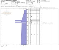
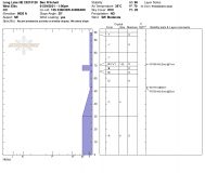
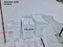
Snowpack: Went hunting for weak snow. Dug numerous holes in this transitional zone on the periphery of the deep snow belt. This area is often representative of weaker parts of the zone, but not as shallow as Spring Creek or Taylor. Height of snow varied from 40-120cm. No collapsing or cracking observed today while traveling in areas of weak snow. Add another 20-30 cm of slab (in the deeper snowpack areas or at higher elevations) and I would expect isolated / stubborn collapsing and the potential for human-triggered avalanches if you find just the right spot. South and west facing slopes have durable, supportive crusts below the most recent storm snow. No current avalanche problem, and not likely to become dangerous with this incoming storm. Northwest and North are thin, and thoroughly faceted. Very little slab structure. Easy to push loose dry avalanches that gouged to near the ground. Sluffing in the deeper parts of the zone can be expected with more than 6-8″ of new snow. Northeast and east have the thickest slabs. Southeast is the touchiest with the stiffest layers (thin crusts) above recently buried and basal facet layers. Northeast through east to southeast remain the bullseye for Persistent Slab avalanches. With Saturday’s loading these slopes will remain the areas of greatest concern.


Photos:

Read Full Observation
01/29/21

January snow 2017-2021

Date of Observation: 01/29/2021
Name: Andrew Breibart


Zone: Southeast Mountains
Elevation: BTL

Weather: calm, near and above freezing. partly cloudy
Snowpack: sticky snow with snow clumping on skins.
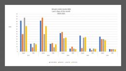
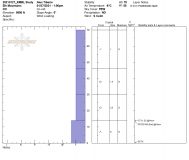
See attached for snow depth and SWE comparison (2017-2021).


Photos:

Read Full Observation
01/29/21

Watching for the persistent slab to wake up below treeline

Date of Observation: 01/29/2021
Name: Jared Berman and Zach Guy

Zone: Southeast Mountains
Location: Coon Basin / Climax chutes
Aspect: North East, South East
Elevation: 9200′ – 11300′

Avalanches: Nothing new
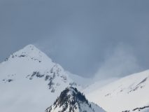
Weather: Warm temps all day. Snow showers early in the morning before skies opened up and the sun popped out for a while. The afternoon brought cloudy skies again and strong winds above treeline from the southwest with visible plumes off of the high peaks.
Snowpack: Traveling through wind-sheltered terrain near and below the treeline, we found slab structures ranging from 30-40cm on southeast and northeast aspects.

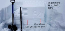
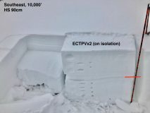
On southeast aspects, slabs from new snow were not as deep averaging about 30-35cm resting on top of a melt-freeze crust that varied in thickness depending on aspect and slope angle. One snowpit dug at 11,000′ on a southeast aspect and 28-degree slope revealed a Fist-4 Finger hard slab resting on top of a thick 4.5cm pencil hard crust. The crust is resting on top of weak facets 1mm in size. This was the only pit we dug that showed propagating results (ECTP21). We also got one collapse on a SE slope where the crust was thinner

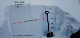
On northeast aspects near treeline, the slab was slightly larger ranging from 35-40cm which is resting on top of 60cm of completely faceted snow. Slabs on these colder aspects are also Fist-4 Finger minus in hand hardness. Two test pits did not show propagating results. However, once we added additional load to the slab, extended column tests showed full propagation (see video below). We skied steeper terrain on northeast aspects with no signs of instability, but steered clear of possible crossloaded terrain.

As we moved lower in elevation below treeline on northeast aspects, the slab steadily became softer and softer until we reached 9500′ where snowpack structure is essentially all facets to the ground, with only 15cm of recent snow on top.


Photos:

Read Full Observation
01/28/21

Quiet Shallow Weak Cement Creek…kind of

Date of Observation: 01/28/2021
Name: Eric Murrow


Zone: Southeast Mountains
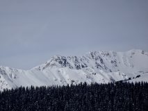
Location: Cement Creek to Reno Divide for photo & glassing then tour on Hunter Hill
Aspect: North East, East, South East
Elevation: 9,000 – 11,800′


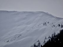
Avalanches: Observed a number of avalanches in the Cement and Brush Creek drainages…all from drifted terrain features. Two slabs in North Bowl on Cement Mountain D1.5s, D1.5 on very drifted NTL feature on Hunter Hill southeast aspect, good size D2 near White Mountain on east aspect ATL(looks to have failed near ground), 5 D2ish slides on east-facing slopes ATL in Twin Lakes drainage(long-distance view – some looked shallow, some looked deep failing)
Weather: Largely cloudy skies but often thin cloud cover with sun visible through clouds. Air temps were mild enough to moisten snow surfaces on south and southeast slopes below 11K. Winds were generally light – no observed transport off high terrain.
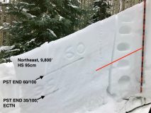
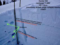
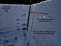
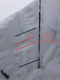
Snowpack: Traveling along Cement Creek corridor snow depths of 60cm near Deadmans TH at 9400′ and ~90cm at 10,800 near Hunter Hill’s east side. Skinning between 10,600′ and 11,800′ ski penetration was generally 8″ with support coming from windboard created by 1/13 wind event – occasionally in sheltered areas ski pen reached deeper than a foot or so. No signs of instability below treeline in sheltered areas (see test profile photo of east BTL slope). Wandering through a near treeline basin I was able to produce a few collapses with one being large, but not rumbling. I dug a profile on a slope adjacent to collapse with recent and previous drifting and found a poor looking structure. Two interfaces can produce avalanches – one below the recent storm snow (failing in facets below a windboard) and large-grained Depth Hoar near the ground (see photo). Applying this test profile to observed avalanches in the Brush and Cement Creek drainages it seems to fit well….shallow avalanches failing at the most recent storm interface and deep avalanches failing near the ground. The features that looked most concerning were near treeline or above treeline but immediately below ridges that allow for good loading and limit scouring…highest terrain (greater than ~12,500′ or so) often looked beat up by the wind. A deep, good looking leeward slope in these areas might be more or at least as concerning to similar slopes in Northwest Mountains/Ruby Range because weak layers look worse out east.


Photos:


Read Full Observation
01/28/21

Avy 2 Observation Tour-Washington Gulch

Date of Observation: 01/28/2021
Name: IAN MCDONALD


Zone: Southeast Mountains
Location: Washington Gulch – a little past Coney’s
Aspect: North East
Elevation: 10500 ft


Avalanches: None observed
Weather: Temperature: 30F
Sky: Broken
Wind: Calm
Precip: None
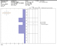
Snowpack: Our group dug 3 pits, height of snow ranged from 125-109cm.
Easy CT results: (3,8,9) SC
Moderate ECTP results: (10,11,16) SC
PST END (40/100,45/100, 65/100)
All results were on the same layer that ranged from 40-45cm depth from surface on the interface of the recent storm.
We observed 3 collapses on flat terrain during the day.
Skied terrain in the lower 30 degree range.


Photos:

Read Full Observation
01/27/21

Pow day

Date of Observation: 01/27/2021
Name: Steve Banks


Zone: Southeast Mountains
Location: Red Lady Glades
Aspect: South East, South
Elevation: 9,800-12,000


Avalanches: Noticed a small fresh looking windslab release from the center of RLB. D1 and maybe a bit older but the crown still looked fresh as compared to this mornings ski tracks. Looks like something significant in 4th bowl of Axtell, though my guess is cornice fall and/or windslab release and not persistent slab.
Weather: Sunny, cool and breezy up high. Snow surface stayed dry despite strong solar. Lots of snow moving near and above treeline. Temps stayed cold as new cloud layer came in after noon.
Snowpack: It’s getting supportive! HS roughly 135 cms as average around the terrain we traveled. More like 90 cms well below treeline. Could feel the old buried crusts in a couple spots, and the pack became quite weak at lower elevations.


Read Full Observation
01/27/21

RMBL Study Plot 01/27/20

Date of Observation: 01/27/2021
Name: Alex Tiberio


Zone: Southeast Mountains
Location: Gothic
Aspect:
Elevation:

Photos:


Read Full Observation
The blog.