New Website: Avalanche Problems

CB Avalanche CenterAvi Blog, Avi-Off-Season

Zach Guy
Forecaster, CBAC 

By now, you’ve probably noticed the CBAC has had a bit of a make-over.  We have spent over a year designing, researching, redesigning, and coding our new website, which we launched this week.   We were operating on an old dinosaur of a web platform and it was time for a new site that matched the current state of the e-world.  This new site has improved graphics, higher resolution imagery, more user friendly from our end and yours, an improved observations platform, a format that is more consistent with avalanche centers nation-wide, and some additional forecasting tools which you can use to make safer decisions in the backcountry.  Bear with us as we work through the kinks and strive to improve the functionality of the site.  

Now let’s jump into a key element of our daily forecasts: the avalanche problem.  The reason we put a lot of focus on avalanche problems is because the flavor of the avalanches we expect to encounter can be more influential in our terrain and risk management than a given danger rating.  For example, not all Moderat danger ratings are created equal.  I move through terrain and make snowpack assessments very differently for a Moderate danger when the only concern is wind slabs, versus a moderate danger involving deep persistent slabs.  The Utah Avalanche Center just published a new tutorial on avalanche problems; its worth a look.  http://utahavalanchecenter.org/avalanche-problems-tutorial.  The CAIC also defines each problem here


This idea of avalanche problems is nothing new to our CBAC users, but we’re presenting it in a slightly different way. The four key elements to the avalanche problem is the avalanche character, its distribution, its likelihood, and its size.  Here’s an example of how we present the problem. You can always click on the little blue “information” icons for more help or info.


The trickiest part of this is the distribution rose: where the problem is located across our terrain.  Imagine a conical shaped peak, and you are hovering above it in your private helicopter.  The inner-most rung is the highest elevation: above treeline, and the outer-most rung is the base of the cone below treeline.  Each triangular octet represents a compass direction, so imagine this conical peak is oriented the same way it would look on a map. Now here’s the important part.  We shade the areas where the problem is most likely.  The problem distribution is never as black and white as it appears on this rose.  This gives you general guidance on where you are most likely to encounter the problem at the regional level, but it is still up to you to make assessments on individual slopes.  Here’s an example: We get a mild snow event with strong westerly winds. Our advisory will probably shade the distribution of fresh wind slabs on leeward aspects (NE, E, SE) near and above treeline because windslabs will be fairly widespread on those slopes.  Given such an event, I can almost always find wind slabs on windward aspects (due West) too, if I seek out cross-loaded features or gullies.  There might be a few slopes below treeline that develop wind slabs as well.  So just because the wind slabs are prevalent on higher elevation, leeward aspects, it doesn’t mean you shut off your snow senses if you’re traveling elsewhere.  We will try to describe these nuances and subtleties in our text, so its in your best interest to read the whole advisory and not just look at the pretty pictures.  

The likelihood is fairly self explanatory.  This is the chance of triggering a slide if you are recreating in steep, avalanche terrain in the parts of the rose that we have shaded, where the problem is most prevalent.  Lastly, we describe the expected size.  Small avalanches are D1’s: relatively harmless to people unless they push you into a terrain trap. Large avalanches are D2’s: they could bury, injure or kill a person. Very large avalanches are D3’s: these could bury cars, destroy a house, or break trees. Historic avalanches are nearing the maximum size a slope can produce. These don’t happen every year.  

We’d like to acknowledge Brandon Clifford, our website designer, and the CAIC for contributing resources and forecasting elements.  We hope you find our new website useful in planning and making safe decisions in the backcountry.
11/26/2014

CB Avalanche Center2014-15 Observations

Name: Evan Ross
Location: Paradise divide area
Date of Observation: 11/26/2014
Aspect: North East
Elevation: 10,000-11,500

Weather: Clearing sky, generally warmer temps then pervious days, west northwest winds gusting strong enough to continue drifting snow at near and above treeline elevations.

Snowpack: Last weekends storm snow was wind buffed and consolidated into a more cohesive slab.  This slab was still fist hard but noticeably more consolidated then previous days. This didn’t seem to affect the outcome of stability tests in the same areas as tests from previous days on the same slopes. Collapsing has decreased from previous days as well, but ECT test still show the potential for avalanching of the persistent slab and week fasted snow on the ground.

Avalanches: 1 natural wind slab within the 48 hours failing on an above treeline cross loaded Southern slope. SS-N-R2-D2

Irwin Snow Obs

CB Avalanche Center2014-15 Observations

Name: Billy Rankin
Title: Irwin Snow Obs
Location: Kebler Pass Area
Date of Observation: 11/26/2014
Elevation: 10,200′

Snowpack: Irwin Storm total was 23″ w. 2.1″ SWE. Storm board was 17″ HS: 29″. There was a widespread rime crust this morning around 3-4 mm thick

2014/11/25

CB Avalanche Center2014-15 Observations

Name: Ian Havlick
Title: 2014/11/25
Location: Kebler Pass Area
Date of Observation: 11/25/2014
Aspect: South, West
Elevation: 10,500

Avalanches: n/a

Weather: S1-S3 snow throughout morning. definitely convective and orographic. light variable winds in all but the most open terrain where the local winds were moderate from the WSW.

Snowpack: 27″ settled snow on HS stake. 15″ settled storm total. 6″ new overnight. Stout MFcr on South and West aspects below treeline. couple pits showed failure under moderate loading steps just below MF crust mid-pack. cracking and one major collapse on below treeline, west-southwest facing slope, that was around 34 degrees in steepness.

11/25/2014

CB Avalanche Center2014-15 Observations

Location: Paradise Divide Area
Date of Observation: 11/25/2014
Elevation: 9,300-11,300

Weather: On and off snow showers producing about 3” of new snow between 9:30am and 3pm. Obscured sky throughout the day with strong enough NW wind to refill some tracks throughout the day but not strong enough to notice the blowing snow.

Snowpack: Snowpack: Found some wind stiffened snow but didn’t find a wind slab problem on the NE terrain at ridgeline. So the take home observations were, where in the terrain traveled was the persistent slab active? The snowpack needed to be deep enough to have a strong enough mid-pack to produce propagating test results. The mid-pack that has any strength is the 11/13 to 11/15 storm sitting over weak facets from earlier this season. This set up can be found down to 9,000ft west of Crested Butte. In this area, about 10,800ft seems to be the elevation where this mid-pack starts gaining enough strength to produce propagating results in snowpack tests that represent the potential for a persistent slab avalanche. Below that average 10,800 elevation on NE aspects the midpack could collapse and would only produce very small radius cracks, or ECTX test results. Above that elevation a pit dug with a 115cm snowpack and 4f-1f mid-pack produced an ECT21 SC and produced other collapses while touring with large radius shooting cracks. Thus, representing areas that could produce a persistent slab avalanche given the right slope angle and terrain feature.

November 26th, 2014

CBACWeather

24 Hour Weather Outlook

Weather Discussion: Since yesterday, 2-4” of additional snow fell around area bringing the prolonged storm totals to 15-20” of snow since Saturday, with 1.5 to 1.8” of water equivalent. Westerly winds have continued to remain elevated, with most remote weather stations showing gusts in the 25 mph range over the last 24 hours. Today, snow showers will gradually diminish by early afternoon as high pressure works into the area today, and takes hold through the weekend.

High Temperature: 25-30º
Wind Speed (mph):10 – 20 mph
Wind Direction: West
Sky Cover: Overcast becoming clear
Snow (in): Trace-1″

48 Hour Weather Outlook

Weather Outlook: The extended outlook looks mild and sunny through Thanksgiving, but another Pacific storm is taking shape and could bring another round of significant snow early next week.

Tomorrows Temperatures: 20-25º
Tomorrows Wind Speeds (mph): 5-15 mph
Tomorrows Wind Directions: W
Tomorrows Sky Cover: Mostly Clear
Tomorrows Snow (in):0″

Snodgrass Avalanche

CB Avalanche Center2014-15 Observations, Avi-map

Name: Brian Goldstein
Title: Snodgrass Avalanche
Location: Crested Butte Area
Date of Observation: 11/25/2014
Aspect: North East
Elevation: 11,000

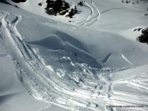
Avalanches: Observed an Avalanche on the Northface of Snodgrass in between first bowl and second above the open pillow zone. Propagated 120 feet wide and was much bigger than the anticipated potential. Probably an R3D2.5. Ran approx. 500 feet into the terrain trap below snapping numerous small trees. Almost propagated an additional 40 feet, but stopped with a major crack on a knob above an adjacent gully. We were observing the terrain from sheltered trees about 5 feet from an open area on the ridge above the rock formations/pillows. Aspect was NorthEast. We stomped around above some convexities with no reaction. Deciding the terrain was unsafe we turned around, walked five feet into the trees and the slope was remotely triggered presumably from a small buried tree. Slid all the way to the ground. The storm slab, and slab from last week, slid on the weak faceted layer at the base of the snowpack, taking the entire snowpack with it. One other wumph was observed in the same area prior to the slide. The crown was approx 60 cm. Consistent crown with no obvious wind deposits, although this specific area is subject to wind loading due to its exposure and openness compared to the rest of the snodgrass trees. Slope angle averaged about 38 degrees as the starting zone.

Weather: Light to moderate winds. Moderate temps (21ish?). Snowing S1.

Snowpack: 60-100 cm

Remotely Triggered Avalanche on 11.25.2014

Catagorized : (SS-R2-D2-AS-O/G)

Observation from 11/24

CB Avalanche Center2014-15 Observations

Name: EM
Title: Ob from 11/24
Location: Kebler Pass Area
Date of Observation: 11/25/2014
Aspect: South
Elevation: 11,500

Weather: Weather – Cloudy skies with light snow falling. Air temps were 17 at trailhead and 8 at 11,500. Winds were light with moderate gusting. Observed a small bit of snow being transported by wind, but low visibility didn’t allow for good views in to the alpine. Ski tracks from Sunday were partially filled in at and near treeline.

Snowpack: Snowpack – while traveling off of skin track at treeline small amount of cracking with in the new snow was visible. Jumped on several steep roll overs with out any results. No collapsing either. Snow profile was dug at 11,500 on open, south facing, 32 degree slope. It showed 65cm snow depth. It was comprised of 30cm of 1-1.5mm facets at ground from earlier in november, a 5cm crust the formed from last weeks sunny skies, and then 30cm of new snow since saturday on top. Test results showed reasonable bonding between new snow and sun crust, no results from jumping on steep rolls or shovel shears. CT showed failures below the sun crust on taps from elbow. These were generally Q2. ECT results would not propagate across entire column only about 30cm and were irregular. It appeared as though there may have been a strong temp gradient directly below the sun crust leading to a weakening of the snow directly below it. But battery in thermometer died so no data.

11/24 Kebler Pass Observation

CBAC2014-15 Observations

Date of Observation: November 24, 2014
Location: Kebler Pass Area
Aspect (N/S/E/W, etc.): N-NE
Elevation: 9800-11400

Returned to the same zone as yesterday, see WD’s report from 11/23. An additional three inches or so and evidence of strong wind activity overnight. Observed some whoomphing and cracking at the top of the skin track on the ridge where there was lots of wind deposition. Pit at the top of the line we skied confirmed the additional three inches up high. Storm snow was still unconsolidated but ran easily on the old surface, we expected to see loose snow sluffing. Entire pack failed on the ground facets with considerable force. No signs of instability on decent of that line. On the second run wrapping around toward exit trees we observed lots of wind loading and a very defined wind slab of 6 inches or so which failed easily on rollovers.

2014-2015 Snow and Avalanche Gallery

CB Avalanche CenterGallery

Forecaster and user submitted snow and avalanche photos from across the Crested Butte Avalanche Center’s forecast area in Elk Mountains of Central Colorado.