Pittsburgh Skier Triggered Avalanche

CB Avalanche Center2015-16 Observations

Location: Paradise Divide Area
Date of Observation: 12/21/2015
Name: Jimmy Buchanan
Subject: Pittsburgh Skier Triggered Avalanche
Aspect: North East
Elevation: 10,000′

Avalanches: Skier triggered hangfire, 65 cm deep failing on 5-7 mm preserved surface hoar and breaking into low angle terrain that is skied regularly.
Weather: Overcast. Light to moderate snowfall throughout the morning.
Snowpack: 50-70 cm of new snow in the last two days. HS ranged from 80 cm to 135 cm depending on terrain and elevation. Storm slab became more substantial with gain in elevation. Observed a preserved surface hoar layer on N/NE aspects above 9,600′.

2015-12-21 13.36.49

2015-12-21 13.39.30

Kebler Snowpack Obs

CB Avalanche Center2015-16 Observations

Location: Kebler Pass Area
Date of Observation: 12/21/2015
Name: Zach Guy, Evan Ross
Subject: Kebler Snowpack Obs
Aspect: North, South East, South
Elevation: Near/Below treeline

Avalanches: Observed one large collapse at ridgeline on a flat slope.
Weather: Light to moderate snowfall through the day. Moderate west to northwest winds at ridgetop. Overcast.
Snowpack: About 6″ of new storm snow. Probing on northerly aspects, found the snowpack ranged from 80 cm to 140 cm. Structure was quite variable. Some slopes held a very soft snowpack throughout, fist hardness. Other slopes held stronger midpack, with basal weak layers. On southerly aspects, the snowpack was shallower, <80 cm.  There was a very thin meltfreeze crust below today’s new snow, and a thicker meltfreeze crust near the bottom (12/11 MFcr), about 50 cm deep.  One pit found no facets above this crust, and decent bonding, ECTN-15 50 cm down on that crust.  Another pit we found a fist hard facet layer above the crust.  The 12/11 crust was thick and on the ground in places, in others, its thin with facet layers below or a crust/facet/crust combo below.

Mountain Weather 12/21/15

CB Avalanche CenterWeather

Date: 12/21/2015

Yesterday’s snow accumulations far exceeded forecasted amounts with a fairly wide range of accumulations reported across the area. Several factors came together yesterday to create more lift then expected as we saw some high snowfall rates. A quick moving disturbance will be exiting our area this morning, kind of like a small wiggle in the flow. We’ll stay in westerly flow after this disturbance but will lose much of the instability in its wake, relying more solely on orographic snowfall this afternoon. So we should be seeing light snow showers or a break in the weather around mid-day today. Heading into Tuesday things really get exciting as the Jet Stream moves over head. Bringing a good tap of moisture on westerly flow while creating good instability. So we’ll have moisture, lots of lift, and good orographic flow. That means snow folks!

Irwin Cat Operation

CB Avalanche Center2015-16 Observations

Location: Kebler Pass Area
Date of Observation: 12/20/2015
Name: Irwin Guides
Subject: Irwin Cat Operation
Aspect:
Elevation:

Avalanches:
Weather: Wx station still down. Obscured sky all day with periods of S‐5 snow. Moderate to strong winds all day, more SW in the morning and W toward the PM.
1‐3” tonight, 1‐3” tomorrow West winds 15‐25 mph.
Snowpack: 8” of new settled to 6”. Lots of minimal surface cracking in today’s new snow due to the intensity and wind. Last week’s snow is becoming more cohesive still. Likely due to warm days and now cold + settlement. Many cracks in steeper roles going full depth, especially near and below treeline (Knob steep, Cocktail), propagation is less (20‐60’) and the slab just doesn’t seem able to pull out. This will be a concern with new snow in the coming days. We are at 2.5” of H2O in the past 6 days.
Newly formed slabs are showing clean shears on crusts in sunny areas. Fast ski cuts are not effective. Heavy dolphin‐ing is the only way to penetrate the slab, and is becoming more and more difficult.

Coneys

CB Avalanche Center2015-16 Observations

Location: Crested Butte Area
Date of Observation: 12/20/2015
Name: JSJ, Donny, Level 2 Class
Subject:
Aspect: North, North East, South East, South, West
Elevation: 9,500-10,800′

Avalanches:
Weather: WEATHER: See PM Instability Form below:
Snowpack: SNOWPACK/AVALANCHE OBS: See PM Instability Form below

unnamed-2

West Brush Creek

CB Avalanche Center2015-16 Observations

Location: Brush Creek Area
Date of Observation: 12/20/2015
Name: Ian Havlick
Subject: West Brush Creek
Aspect: North East, East, South East, South
Elevation: 9500-12000

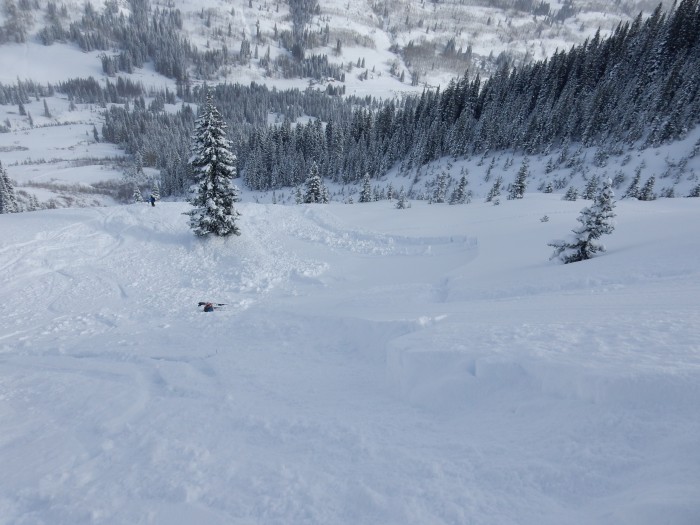
Avalanches: Popped a decent storm slab out on a steeper roll on NE facing avalanche path BTL. Slab was probably 60cm, and had some push to it., collapsing and propagating probably 20ft. Did not feel comfortable on steep terrain today, however, did ski small steep features nervously.
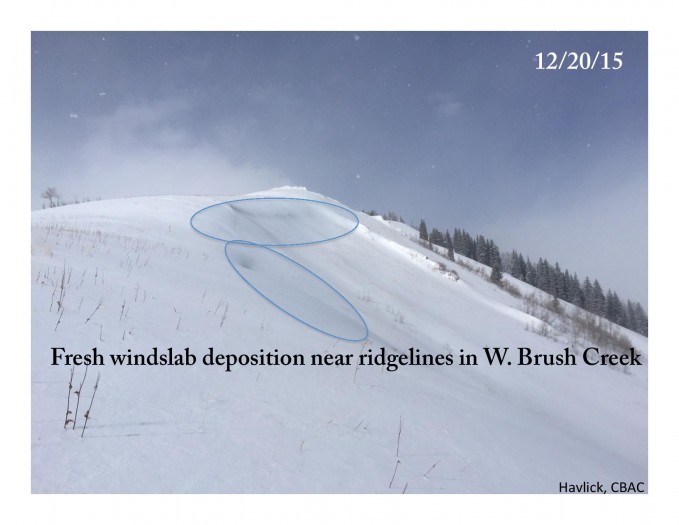
Weather: Cold air advection and orographics was surprisingly heavy and last throughout tour, showery in nature ranging from S-1 to S5. Around 6″ new in Brush overnight and today. When we gained more near treeline ridgeline, W-NW wind was a steady 15mph with a few gusts to 30. No real Solar effect on any terrain today.
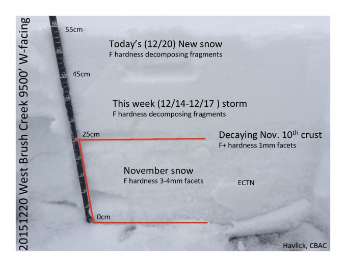
Snowpack: Snowpack was surprisingly deep, but expectations may have just been that low… HS ranged 40cm to 120cm depending on wind effect and elevation. 3-5mm depth hoar first 10cm, smaller facets, with about 15-50cm new snow which was becoming slabby , especially below treeline where new snow is cohesive enough hold slab above super weak, larger grained facets. Extended column tests showed no slab firm enough for ECT to show, but was getting localized collapses around skis all day. one ECT near ridgeline after finding old hardslab. ECTPV and ECTPE SC below hardslab. Windloading confined to ridgelines where we travelled. No wind effect BTL, aside from open meadows.

IMG_2741

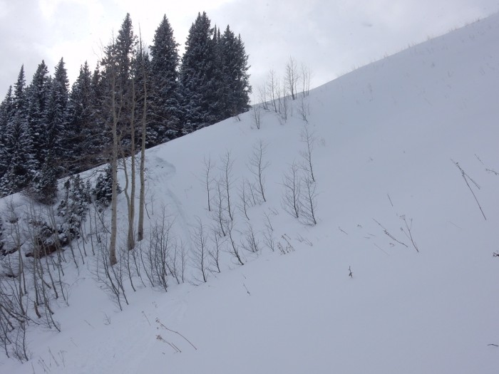
skier triggered BTL pocket on steep roll. Lots of hangfire 2nd skier avoided by skiing bed surface

20151219WBrushPit9500-page-001 BrushRidgeline20151220-page-001


Mountain Weather 12/20/15

CB Avalanche CenterWeather

Date: 12/20/2015

A small trough will bring a return to light snow showers today. Winds last night were forecasted to be fairly strong above treeline and those westerly winds will continue today. A few other very small disturbances or wiggles in the flow will keep us in unsettled weather heading toward Tuesday. Around the Tuesday time frame, the jet stream moves over Colorado while pulling in good pacific moisture. Snowfall accumulations will start ramping up with the arrival of the jet and this moisture.

Anthracites

CB Avalanche Center2015-16 Observations

Location: Kebler Pass Area
Date of Observation: 12/19/2015
Name: Ian Havlick
Subject: Anthracites
Aspect: North, North East
Elevation: 10500-11500

Avalanches: observed small windslab (50′ x 10-20″ deep) on NE facing slope in extreme terrain on Whetstone, as well as similar size windslab on SE facing slope at ridgeline in Anthracites.
Weather: Overcast, with cold morning but warmed nicely. Light SW breeze at ridgetop today. Solar was present but not intense.
Snowpack: Travelled standard uptrack in Anthracites, snowpack was consistent 80-120cm deep, most notably a very widespread layer of surface hoar from last night’s cold, clear, calm night. Surface hoar 4-6mm, and present in shorter pungey trees all the way to branches. In darker timber SH was NOT present. Also evident was drifts in trees from strong NW winds last few days.

See video for test pit results. ECTX, and ECTP30 – sudden collapse at ground on 3-5mm depth hoar.

no signs of instability today aside from spooky pit results.

Anthracites20151219_graphicalpit_Havlick-page-001