Scarp Ridge

CB Avalanche Center2015-16 Observations

Location: Kebler Pass and Crested Butte Area
Date of Observation: 02/17/2016
Name: Alex Banas
Subject: Scarp Ridge
Aspect: East, South East, South, South West
Elevation: 11-12,100

Avalanches:
Weather: Few clouds in the am and calm winds trending to moderate with strong gusts from the W SW AT 13:00 the top of Mt. Emmons. Warm temps.
Snowpack: Throughout the am light westerly winds kept the snow surface cool before turning moist on east and southeast aspects around 1200. No obvious signs of instabilities on slopes up to 36*.
Indy Basin: 10cm ski pen 45cm boot pen on the skiers left side near treeline. New snow preserved on west facing slopes 10cm of dry snow, dust on crust.
Elk Basin: SE facing shot from the ridge provided moist, dust on crust type skiing. Roller balls.
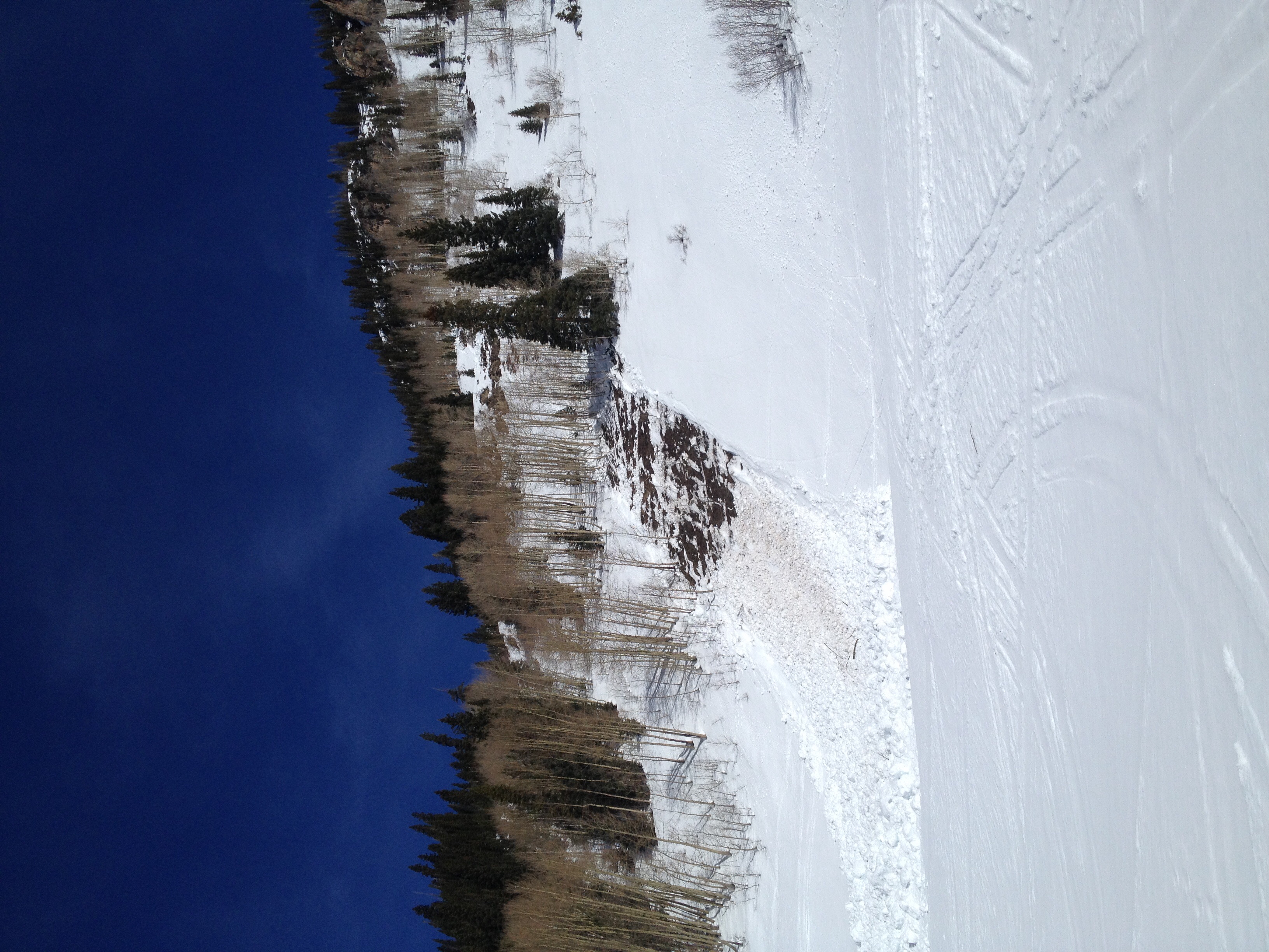
Evans Basin: The east wall looked blown out, roller balled and one small wet loose. The S line from gunsight looked clean and good skiing till the basin.
RLB: Variable, ripple to windboard. Dry snow till 10,600′ where the egress turned to mank.

Mountain Weather 2/18/2016

CB Avalanche CenterWeather

Date: 02/18/2016

Batten down the hatches. We are in for some significant winds today at the front end of a fast-moving low pressure system moving on shore this morning. Winds have already mixed out the temperature inversions in the upper valley, with temperatures near 40 this morning in Crested Butte and remaining in the mid to upper 30’s in the mountains. We could see spotty snow showers today, but accumulating snowfall will mostly hold off until this evening, when a cold front pushes through just after sunset. A quick 1-4″ to should accumulate with frontal passage, and winds decreasing in its wake. Drier zonal flow sets up for the weekend.

CBAC Snodgrass Study Plot Snowpit

CB Avalanche Center2015-16 Observations, Snow Profiles

Location: Crested Butte Area
Date of Observation: 02/17/2016
Name: Jimmy Buchanan
Subject: CBAC Snodgrass Study Plot Snowpit
Aspect: North East
Elevation: 9800′

Avalanches: None
Weather: See profile.
Snowpack: See profile.

Snodgrass-Feb.-17

Snowpack obs

CB Avalanche Center2015-16 Observations

Location: Crested Butte Area
Date of Observation: 02/17/2016
Name: Jeff Banks
Subject: Snowpack obs
Aspect: East, South, South West, North West
Elevation: 9,000-9,800

Avalanches: No signs of instability
Weather: \Sunny and warm. Calm winds increasing to Moderate & gusting to Strong as the day went on.
Snowpack: Some light transport, not much snow available for transport because of crusty surfaces.

Snow obs

CB Avalanche Center2015-16 Observations

Location: Crested Butte Area
Date of Observation: 02/17/2016
Name: Steve Banks
Subject: Snow obs
Aspect: East, South, West
Elevation: 11,900-10-500

Avalanches:
Weather:
Snowpack: East facing slopes in the morning had breaker crust but skiable. Quickly warming temps were hedged by increasing winds and clouds throughout the day. Slightly above freezing temps led to moist snow surface and softening crusts in the afternoon.
Found dry snow in protected WNW terrain sheltered by trees. No signs of instability on slopes up to 34 degrees. In the afternoon a refreeze zipper crust was forming on sunnier slopes

Wet avalanche

CB Avalanche Center2015-16 Observations

Location: Paradise Divide Area
Date of Observation: 02/17/2016
Name: Dustin e
Subject: Wet avalanche
Aspect: North East, East, South East, South, South West, West
Elevation: 9500-12500

Avalanches: R1-d2 natural wet slab on the southern side of purple ridge. Appeared as though wet loose debris from a rock band up high stepped down once it reached the weaker snowpack at lower elevation.  **CBAC note.  This slide is from a previous warmup. It was first observed the morning of 2/16**
Weather: Hot. Mild breeze up high kept things cool
Snowpack: Firm. New snow sat above v-day sun crusts and wind board. Did not punch through v-day interface all day, difficult to impossible to kick steps into this layer in many areas. Saw some cracking in new snow but slabs were 4″ or less and did not propagate far. New snow distribution above tree line is variable and as expected for nw winds.

image1

Ruby Range

CB Avalanche Center2015-16 Observations

Location: Paradise Divide Area
Date of Observation: 02/17/2016
Name: Zach Guy
Subject: Ruby Range
Aspect: North East, East, South East, South
Elevation: 9,400-12,500 ft

Avalanches: Some more rollerballs today on E and SE aspects A/NTL, and two very small wet loose on a SE aspect ATL, harmless in size. Had good views of a lot of the Ruby Range and no other fresh activity. Some older wet loose on below treeline southerlies from previous warm ups, one was a D2 in size and gouged to the ground (See Dustin’s photo).
Weather: Light to moderate SW winds with no snow transport. Clouds increased from clear to thin broken by PM. Warm temps
Snowpack: Near and above treeline, about 2-5″ of settled storm snow became moist to wet on E to S aspects, over the solid and still frozen VD crust. Surfaces refroze around 2 pm. as clouds and winds increased. Sloppier snow observed below treeline. No signs of instabilities on various aspects and steep terrain, except some minor rollerballs.

Small wet loose and rollerballs on a SE aspect ATL

Mountain Weather

CB Avalanche CenterWeather

Date: 02/17/2016

This morning, many valley locations look to be in the teens and single digits, while remote weather stations above 10,000ft hover in the 28-30ºF range at 0500. Today will be mild and clear, with increasing winds in the afternoon and throughout the night as a fast moving Pacific system barrels across the Great Basin and into western Colorado. This system is not looking to be a huge snow maker (3-6”), but winds look impressive at all elevations (50-80mph), and temperatures mild.

Snodgrass

CB Avalanche Center2015-16 Observations

Location: Crested Butte Area
Date of Observation: 02/16/2016
Name: Evan Ross
Subject: Snodgrass
Aspect: North East
Elevation: 9,400-11,100

Avalanches: Triggered a few very small facet sloughs in steep terrain that previously avalanched.
Weather: Patly cloudy due to high thin clouds. Calm winds during our tour, but we were either in protected areas or a to low elevations. Didn’t see any snow blowing off the peeks.
Snowpack: Ski pen in the 10-15 cm range with boot pen around 30cm. Many slopes have already avalanched and pose a very small facet slough problem if they are in the 40 degree range. Regarding the slopes that didn’t avalanche; some don’t have much structure at all, weak but still suportive. Others have obvious persistent slab structure, but it was unreactive. HS was around 100-130 on slopes that haven’t avalanched. Dug on one protected slope with an HS of 100cm. 1f decomposing slab over basel 4f, estimated 2mm facets. Slope test was 6 people kick turning on slope with no collapsing. The structure exists for some chance of an avalanche to happening, though we didn’t find the right place and didn’t observe any obvious signs to instability.

Snodgrass

CB Avalanche Center2015-16 Observations

Location: Crested Butte Area
Date of Observation: 02/16/2016
Name: Steve Banks
Subject: Snodgrass
Aspect: North East, East
Elevation: 9,400-11,100

Avalanches:
Weather: Partly cloudy and warm with moderate winds from the NW. Some plumes noted at higher elevations, but no evidence of wind transport NTL or BTL.
Snowpack: Was able to ski cut a fresh windslab on a small, steep convex roll on an obviously drifted and cross loaded feature around 10,000′ on a NE facing slope.
Quick snowpit in same area (but not cross loaded) showed 4 cm of new snow over rounding facets from 4f to 1f. ECTP 27+1 PC on the hardness change 37cms deep. Basel facets are large, but rounding and sintering.