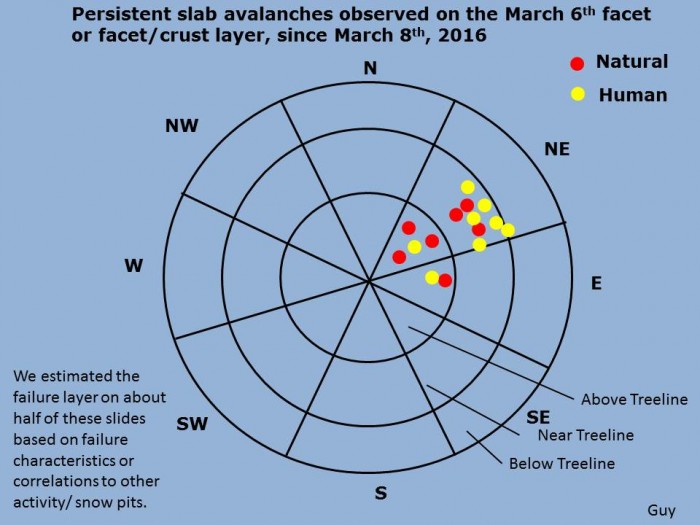
Mountain Weather

CB Avalanche CenterWeather

Date: 03/31/2016

A disturbance embedded in northerly flow will sag over Colorado today. Clouds should quickly fill in the blue skies this morning, and a couple of inches should accumulate by the end of the day, favoring the northern end of our forecast zone. A high pressure ridge begins to broaden and move over the West, bringing a dry and warming trend through the weekend.

4″ new, no instabilities

CB Avalanche Center2015-16 Observations

Location: Kebler Pass Area
Date of Observation: 03/30/2016
Name: Zach Guy
Subject: 4″ new, no instabilities
Aspect: South East, South, South West, West
Elevation: 10,000-12,000

Avalanches: Some brief views of southern Ruby Range and Scarp Ridge, with no recent avalanches.

Weather: Overcast and broken skies, Periods of S-1 to S1, with 2″ of accumulation through the day. Calm winds in the morning increased to moderate with stronger gusts by the afternoon, variable directions but generally SW. Light snow transport in the PM. S3 at the end of the day.

Snowpack: 3-4″ of creamy storm snow, with minimal signs of wind drifting at all elevations. Fell on thick, supportive crusts on ESE to SW aspects, and settled powder on due west. No signs of instability.

Mountain Weather

CB Avalanche CenterWeather

Date: 03/30/2016

The low pressure system over Utah is shearing apart, bringing wrap-around northerly flow out of Wyoming this morning. We could see a couple more inches of snow later today as moisture streams in from the north boosted by afternoon convection, favoring the northern edge of our forecast area. Another wave diving down from Montana will bring additional snowfall on Thursday. Conditions start to dry out and warm up for the weekend.

Mountain Weather

CB Avalanche CenterWeather

Date: 03/29/2016

Another complicated spring storm rolls into the Elk Mountains today. A deep low centered over the Utah/Nevada border is streaming warm moisture into our region under southwest flow. Colder air aloft and a strong surface front will amplify snowfall later this afternoon, and some favored locations could see 8″ or more by sunset. The low retrogrades tomorrow bring northerly flow and continued lighter snowfall.

Climax slide photos

CB Avalanche Center2015-16 Observations, Accidents, Avi-map 15-16

Location: Crested Butte Area
Date of Observation: 03/28/2016
Name: Zach Guy
Subject: Climax slide photos
Aspect: North East
Elevation: 10,850 ft

Avalanches: Photos of Climax Chutes near miss below.  The crown is on an ENE aspect wrapping to NE at roughly 10,850 ft.  You could clearly see a dust layer on the bedsurface of a large soft slab, roughly 2 feet deep. (Probably failed on the March 6 crust/facet layer), and the slide stepped down to the ground further down slope, which wasn’t a whole lot deeper on this path, due to numerous slides already this season. From my limited vantage point, I’d rate the slide: SS-ASu-R3-D2.5-O/G
Weather:
Snowpack:

3/28. Skier triggered persistent slab in Climax Chutes. NE aspect NTL

3/28. Skier triggered persistent slab in Climax Chutes. NE aspect NTL

Debris washed over cliff bands near the runout

Debris washed over cliff bands near the runout

3/28. Near miss in Climax Chutes

3/28. Near miss in Climax Chutes

Near Miss Climax Chutes

CB Avalanche Center2015-16 Observations

Location: Paradise Divide Area
Date of Observation: 03/28/2016
Name: Kim Carroll Bosler
Subject:
Aspect: North, North East
Elevation: 9000?

Avalanches: At 11:05 am I watched a good size avalanche rip from Climax Chutes (I think- I’m not a backcountry skier) as I was skate skiing on Mike’s Mile almost directly below the point of release. Luckily, it landed in a bowl and did not proceed up the bowl’s incline and on down to the valley floor where I was. Just a minute or two later a much smaller avalanche let go on a neighboring smaller chute. About 20 minutes later, as I was with other Nordic skiers calling out trying to determine if people were in trouble, we saw three people descend the ridge. Eventually the one skier and two snowboarders who had triggered the slide came out safely. Close call.
Weather: Sunny and warm.
Snowpack: Sun crust turning slushy.

Climax Chutes

CB Avalanche Center2015-16 Observations

Location: Crested Butte Area
Date of Observation: 03/28/2016
Name:
Subject: Climax Chutes
Aspect: North East
Elevation: 11,100′

Avalanches: R3-D3 avalanche sympathetically released 300′ above skier. Partner in safe zone felt a collapse as skier crossed gully from SE to NE aspect, likely at a shallow area around willows. Partners in safe zones were able to notify skier before he was caught. Take home point- don’t hoot and hollor when your friend is getting sweet face shots, it may be hard to distinguish from “AVALANCHE!”. It was super hard to see the crown as we didn’t see it from our safe zone and couldn’t see it until we looked back up from the Nordic trail at valley bottom. Best guess would be 18″ crown stepping down to the ground in some spots. I gave it the r3d3 because it ran 9/10ths of it’s path starting 300′ from the ridge and running ~2200′ entrenching an impressive amount of snow on the way and spilling over a cliff at the bottom. Probably about 200′ wide jagged crown, in the trees, quickly narrowing to the 25′ width of the chute it self. The first skier watching from the safe zone yelled to me, I looked up from my safe zone and saw the powder cloud and was able to yell to the man skiing. He pulled out to the right just in time…no big deal until we realized we weren’t in the exact shot we thought we were in and if he had taken the ride over the cliff face he wouldn’t have had much of a chance. I was thinking more d2 but it would have crushed a car for sure.  We made several decisions prior that kept us safest in the event of the worst BUT 1) I’m no longer gonna shoot with glee when face shots are had and save shouting for emergency situations only and 2) take way more photos before dropping into an area that’s new to me
Weather: Partly cloudy, no precip, temp in the 30’s, light winds out of the S/SW
Snowpack: