

Well that’s weird….
Originally published in the Crested Butte News in 2018
Well that’s weird…. This past weekend, a large wet slab avalanche ran off Gothic Mountain’s east face. A wet slab avalanche is an avalanche that releases upon a wet layer buried within the snowpack. In this case, the wet layer formed from water draining into the snowpack from melt at the snow surface after 3 consecutive nights without a freeze, coupled with intense solar radiation. Reviewing the statewide avalanche occurrence database which goes back to 2010, this is the only wet slab avalanche observed in November, statewide. You can get more details about this unusual avalanche and other recent observations.
If I’ve learned anything about avalanches in the last 20 years, it’s that weird weather prompts weird avalanches. We’re off to a weird start. It’s not the lack of snow that strikes me as weird. It’s not the weak layers developing from paltry early season snow cover. What’s weird is the unseasonable warmth. On November 17th, our first big storm of the winter brought rain and lightning. Out in Gothic, billy barr measured the highest density storm snow ever recorded during November in his 50+ years of records. Long-standing daily high-temperature records came crashing down this past week. Locally we set new all-time maximums three days running on November 25, 26, and 27th. Lately, people have skied corn on sunny slopes where the snow is deep enough to travel. I saw blue jeans and tank tops in the lift lines at CBMR. Seriously, is this spring break??? Bottom line, it’s weird.
So what does this mean for the coming winter. Well, the sages haven’t written our fate in stone yet. At this point, I think we can count on persistent avalanche problems in our shady terrain once Mom Nature blankets the mountains in a slab of cohesive snow. What’s in question is how future snow will behave on the “shoulder” aspects of West and East, where the sun’s influence has created surprisingly supportive crusts. Will these crusts support the winter’s snowpack well, or will they allow a dangerous load to accumulate, failing deeply and catastrophically later in the winter? Only time will tell.
As we wait for winter to arrive, go ahead and get yourself prepared for the coming backcountry season by attending two great Crested Butte Avalanche Center events:
Mountain Weather Forecast for Friday, December 1st, 2017
Date: 12/01/2017
Above average temperatures, light southwest winds, and dry weather look to dominate today and into the weekend. We should see very warm temperatures forecast for Sunday, as warm southwest winds will kick up ahead of the Monday disturbance. Unfortunately, Monday’s storm looks to fizzle without dropping much snow. I’ll save you the dread of looking at the long range models and give you a hint… Fried eggs through the first week of December (at least)..
Today
High Temperature: 38
Winds/Direction: 10-15
Sky Cover: Partly Cloudy
Irwin Snow: 0
Elkton Snow: 0
Friend’s Hut Snow: 0
Tonight
Low Temperature: 27
Winds/Direction: 10-15
Sky Cover: Partly Cloudy
Irwin Snow: 0
Elkton Snow: 0
Friend’s Hut Snow: 0
Tomorrow
High Temperature: 40
Winds/Direction: 10-15
Sky Cover: Mostly Clear
Irwin Snow: 0
Elkton Snow: 0
Friend’s Hut Snow: 0
Site visit to Gothic East Face apron
Location: Crested Butte Area
Date of Observation: 11/27/2017
Name: Ben Pritchett
Subject: Site visit to Gothic East Face apron
Aspect: North, North East, East, South East
North to northeast = weak, faceting snow, topped w/ temperature crust, avg HS 40-50cm.
East = dense, moist, supportive surfaces, with frozen ice columns through dry snow connecting to the ground (“percolation tubes”), avg HS 10-30cm.
Southeast to south = moist to wet well-developed Melt Forms (“corn”), avg HS 5-20cm.
November Wet Slab
Location: Crested Butte Area
Date of Observation: 11/26/2017
Name: Ben Pritchett
Date of Observation: 11/26/2017
Name: Ben Pritchett
Subject: November Wet Slab
Aspect: East
Elevation: 12,200
Aspect: East
Elevation: 12,200
Avalanches:
This avalanche was first observed at 8am on Nov 26th, and reported to the CBAC around 3pm. The debris was described as gleaming white, looking fresh at 8am, though the observer assumed it likely ran the afternoon prior (Saturday, November 25). By the time I got eyes on the slide at around 3:15pm, it was in the shadows, so all details reported here are based on the attached photo and phone call with the observer.
A photo from prior to Nov. 17 storm does show the presence of old snow in the particular location of this avalanche, and the avalanche photo does show a white bed surface. Reports from East facing terrain on Mt. Bellview indicated that snow surfaces were wet ~15cm from the surface at around 12,000′, so I presume melt-water pooled on the Nov. 17 interface, releasing this slide on the afternoon of Nov. 25.
Weather:
Snowpack:
 IMG_4835
Old Wind Slab on Mt. Bellview
Location: Paradise Divide Area
Date of Observation: 11/23/2017
Name: Turner Peterson
Date of Observation: 11/23/2017
Name: Turner Peterson
Subject: Old Wind Slab on Mt. Belliview
Aspect: South East
Elevation: 12,000′
Aspect: South East
Elevation: 12,000′
Avalanches:
Saw this old avalanche that probably ran Nov 20th during the North winds, after the Nov 17th storm.
Weather:
Snowpack:
 Belleview-old-wind-slab
Fall updates saved
Issued 6:30 am, Friday, November 24th, 2017, by Ian Havlick
Despite our string of sunny days and warming weather, triggering an avalanche in isolated terrain features remains possible. Steep, high elevation, northerly facing terrain holds enough snow and poor structure to warrant caution and avoidance. The dilemma we all currently face is that the areas deep enough to skim above the rocks on skis or board, are the exact places most likely to trigger a lingering persistent slab avalanche.
Weak, sugary, faceted October snow was recently buried by our first significant storm of the year which dropped 10-20 inches of snow across our surrounding backcountry. We observed dozens of small to large natural and human triggered avalanches last week, with a very close call nearby in Aspen on November 18th. A bit of wind at higher elevations moved some of that powdery snow into stiffer windslabs in lee and cross loaded gully features, adding to the potential slab resting above that weak faceted snow just above the ground. Most recently, warm and unseasonable temperatures over Thanksgiving in the Crested Butte area has added some surface crusts to slopes facing east through south through west, with even some melt-freeze crust formation on lower elevation northerlies.
If after that quick early season summary still has you chomping to get out, get some exercise, and slide on some snow….you are braver than I. It should be business as usual out there. Everyone should have a beacon, shovel and probe. Inspect that equipment, conduct a beacon check in the parking lot (even if you start walking on dirt), and dust those cobwebs off. Once on snow, it should be easy to collect valuable snow observations with hand pits and constant probing with a pole. Look and feel for denser snow resting above weak sugary snow. That is the classic slab avalanche structure to avoid, strong over weak. Look and listen for cracking and collapsing as you travel, keeping in mind that if there are previous tracks on the slope, parties before you may have gathered valuable information like collapsing or whumphing, leading you to a false sense of stability. For each day of blue skies and mild temperatures, the likelihood of triggering an isolated persistent slab avalanche decreases, but poor snow structure demands respect, because if you are wrong, a nasty ride into rocks, stumps, and other early season hazards is likely.
For more information, scroll down and read previous conditions updates. The Crested Butte Avalanche Center will post the next conditions update on Sunday, November 26th. Full Operations and daily avalanche advisories will begin after enough snow accumulates.
Issued 6:45 am, Wednesday, November 20, 2017, by Ben Pritchett
Persistent slab avalanches remain a possibility in steep terrain on the shady side of the compass near and above treeline. While these slabs are becoming less reactive than they were during our avalanche cycle this past weekend, they remain a serious hazard to people seeking out turns in the Ruby Range, Paradise Divide, and along the spine of the Elk Mountains. Given the thin snowpack overall, any ride in an avalanche is likely to beat you up bad. Consider the incredible luck in this recent avalanche accident just on the other side of the Elk Mountains. Here’s a picture of the avalanche, a great illustration of the kind of terrain feature where our problem lies.

Don’t underestimate the potential for a deep burial despite the paltry look of the snow cover. Here’s a recent slide, the crown, and 8 foot deep debris above Emerald Lake, near Schofield Pass.


The one additional consideration on top of our Persistent Slab avalanche problem literally lies on top of it. Tuesday afternoon we picked up several hours of west to northwest winds that drifted snow in alpine terrain on the east half of the compass. These fresh drifts accumulated several inches deep in the same features that held snow in October, hence the overlap.
Consider these fresh drifts as indicators of the Persistent Slab avalanche problem lurking below. In terms of where to travel safely and where to expect avalanches, change will be slow to come. Your safest bet is still to choose slopes on the sunny half of the compass where the most recent snow sits directly on the ground as illustrated in the first image below. If you venture into the shade, on slopes facing northwest to northeast, stick to low-angled features out of avalanche terrain.
Given that these weak layers will be slow to heal, Evan’s storm recap on Monday still rings true. I’ll leave his comments and photos below as additional detail for those venturing into the high country.
The Crested Butte Avalanche Center will post the next conditions update on Friday, November 24th. Full operations and daily avalanche advisories will begin after enough snow accumulates.
Issued 7:15 am, Monday, November 18, 2017, by Evan Ross
A large winter storm on November 17th has kicked off our winter season. This storm left the area with a Persistent Slab avalanche problem and numerous skier triggered avalanches over the weekend as seen on the Observation Page. This dangerous avalanche activity was reported from both our area and around the state. Between this avalanche problem and all the recently buried rocks, backcountry travelers need to stay heads up this week.
The November 17th storm deposited over 20” of snow at Schofield Pass in the northwest portion of our forecast area, and 9” of snow at the more centrally located Crested Butte Mountain Resort. These numbers help highlight where the mountains received enough snow to create the current Persistent Slab avalanche problem. There are two ingredients necessary for this avalanche problem: 1) More than 10” of new snow on the 17th, and 2) old buried weak layers from October. These conditions primarily line up in the Paradise Divide and Kebler Pass portions of our forecast area, at near and above treeline elevations, on slopes facing northwest to northeast. West and east facing slopes have appeared less reactive, but could still harbor the Persistent Slab issue on shaded portions of the slope. Moving to aspects further south around the compass rose, there is only the November 17th snow on the ground, thus no current avalanche problem. Ground debris just under the snow surface would be the main hazard.
This video from before the November 17th storm highlights where old weak snow is at the bottom of the snowpack. While this video on November 18th highlights the current avalanche problem and the additional hazards of a small avalanche causing traumatic injuries as it pushes you into uncovered rocks or ground hazards.
Your ideal terrain should have one layer of snow on the ground with a smooth grassy ground surface like this:

Stay away from slopes over 32 degrees in steepness with old weak snow on the ground that look like this:

Snodgrass obs
Location: Crested Butte Area
Date of Observation: 11/21/2017
Name: Alex Tiberio
Date of Observation: 11/21/2017
Name: Alex Tiberio
Subject: Snodgrass obs
Aspect: North East, East
Elevation: 10,000
Aspect: North East, East
Elevation: 10,000
Avalanches:
Weather: Light snow with 1.5″ new overnight
Snowpack: The E/NE aspects held snow from October and this was noticeable in a couple quick hand pits. Crappy sugary snow below the more recent snow. Some whumpimg and shooting cracks near 10,000 feet. No reaction on a ski cut. Snow still quite thin hit several small rocks on descent.
Maritime in the Rockies
Location: Paradise Divide Area
Date of Observation: 11/20/2017
Name: Ben Pritchett
Date of Observation: 11/20/2017
Name: Ben Pritchett
Subject: Maritime in the Rockies
Aspect: North East
Elevation: 10,600′
Aspect: North East
Elevation: 10,600′
Tried to go hunting for a persistent slab problem in the Anthracites, but the snowpack was simply too thin to pose an avalanche threat. Reversed course and drove to Rustler’s Gulch to see if the persistent slab problem existed around the Schofield Pass elevation.
Avalanches:
Observed several old avalanches, previously reported, off Baldy’s NE face into Emerald Lake.
Snowpack:
Pretty thin out there overall. Generally 30-4ocm in most of the upper East River Valley. Only very near Schofield Pass did we get into a deeper snowpack that averaged ~50cm.
The low snow levels at the beginning of the November 17th storm limited accumulations until the second half of the storm, when the graupel began to pile up! During the beginning of the storm slashing rain fell in downtown Crested Butte, and here in the upper East River valley mixed rain and snow fell and formed a crust at the bottom of the storm snow.
The snowpack we observed at this site was “right side up” with, with no results in multiple snowpack tests.
Looking at the landscape, the Persistent Slab problem appears isolated across the mountain range, found only in a small proportion of the higher elevation Northly slopes of the Ruby Range and Schofield Pass area.
 IMG_0876-1
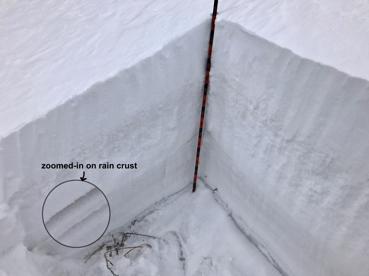 IMG_0875-1
 IMG_0874-1
 IMG_0873-1