Mountain Weather
Date: 12/30/2017
Unseasonably warm weather continues, though a weakening cold front will clip the northern mountains. All we will see around the Crested Butte backcountry is a slight increase in cloud cover, and westerly winds. Blue skies, temperatures in the mid to upper 30s, and light west winds near and above timberline will prevail. Some mountain locations have been struggling to dip much below freezing recently above the cold morning valley inversions. Septembuary. Yikes. Enjoy it I suppose…storms are a brewing in the Pacific for later next week.
-
Today
High Temperature: 38
Winds/Direction: 10-20/WNW
Sky Cover: Partly Cloudy
Irwin Snow: 0
Elkton Snow: 0
Friend’s Hut Snow: 0 -
Tonight
Low Temperature: 15
Winds/Direction: 10-15/W
Sky Cover: Partly Cloudy
Irwin Snow: 0
Elkton Snow: 0
Friend’s Hut Snow: 0 -
Tomorrow
High Temperature: 35
Winds/Direction: 5-15/W
Sky Cover: Mostly Clear
Irwin Snow: 0
Elkton Snow: 0
Friend’s Hut Snow: 0
snow on rocks, or dirt, or grass, or sharks
Location: Paradise Divide Area
Date of Observation: 12/29/2017
Name: Evan Ross
Subject: snow on rocks, or dirt, or grass, or sharks
Aspect: East, South East, South
Elevation: 9,500-12,560
Avalanches:
Checked out the Augusta avalanche reported after the Christmas Storm. In a pit below the crown about 100ft and off the left side of its flank the HS was about 60cm’s. Basically, the Christmas Storm was sitting on the 12/23 wind event and denser snow, down to the ground. Any previous snow was poorly distributed through the rocky terrain. ECTN at this interface on small decomposing grains. The Augusta natural avalanche appeared to fail on this interface and not at the ground. The avalanche size was an R1 in the terrain, while debris where difficult to map as the snow surface has blown back over and been blended back in.
Weather: Few clouds in the morning becoming clear by afternoon. Moderate westerly winds at 12,560.
Snowpack: On south and southeasterly facing slopes there wasn’t much difference in snowpack structure from 9,500ft up to 12,560ft, other then snowpack depth. ECTX at 11,200ft on SE facing 33 degree slope. ECTN at 12500ft on SE facing 36 degree slope. Small column tests could produce resistant shears below the Christmas Storm on non-persistent decomposing small grains. On these aspects throughout the elevation traveled the snowpack begin with the 12/21 storm.
Turned around on one ENE facing slope that was a small roller in the terrain. As the snowpack doubled in hight with very weak snow below stronger snow….
Photos:

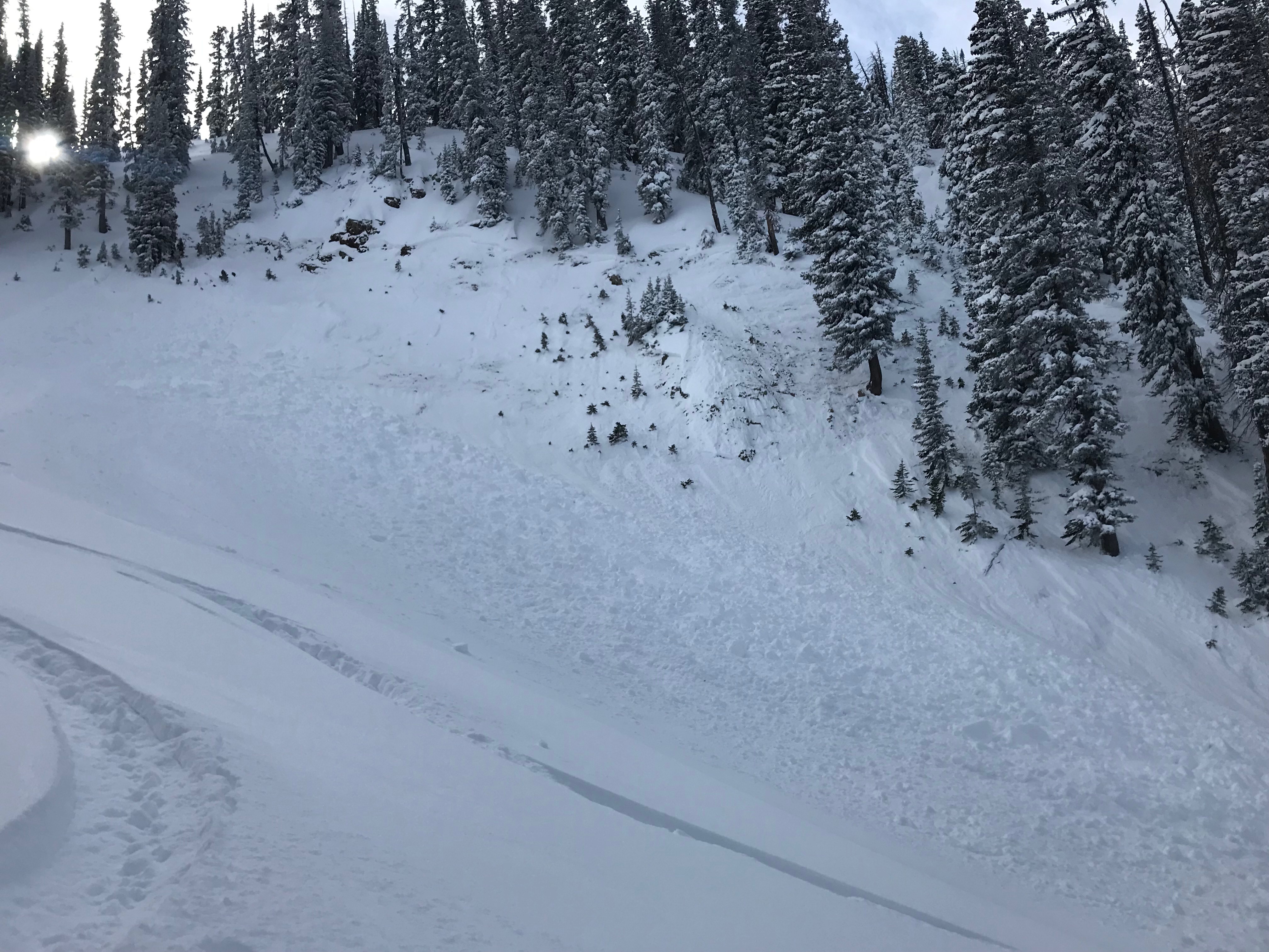
Slab avalanche that failed during the Christmas Storm on a steep easterly facing slope just below 12,000ft. A more recent loose dry avalanche can be seen lookers left.

Turned around on this easterly facing slope that was a small roller in the terrain. As the snowpack doubled in hight with very weak snow below stronger snow….

Snowpack at about 11,500ft on a southeasterly facing slope. Any snow previous to 12/21 was very thin and poorly dispersed through the terrain.0

Snowpack at 11,000ft on a southeasterly facing 30 degree slope.

Snowpack at 12,500ft SE aspect. Basically, the Christmas Storm was sitting on the 12/23 wind event and denser snow, down to the ground. Any previous snow was poorly distributed through the rocky terrain. ECTX on the 12/23 interface on small decomposing grains.

Natural slab avalanche that likely failed near the end of the Christmas Storm. NNW aspect at 11,400ft.

Wet avalanche debris below a southeasterly facing terrain i the upper Middle Anthracite Creek.

Snowpack coverage on the north face of Augusta Mountain. Cross loaded or blown out was the theme.
Looking up at the Augusta avalanche that failed during the Christmas Storm.
Mountain Weather
Date: 12/29/2017
Another day of unseasonably warm temperatures and plentiful sunshine today before a northerly system clips the state, bringing with it an increase in cloud cover and dip in temperatures on Saturday. Previous model runs were showing a slight chance in snow flurries but it looks like any snow will fall north of I-70. Looking forward to a potential pattern change the second week in January.
-
Today
High Temperature: 37
Winds/Direction: 15-25/WNW
Sky Cover: Mostly Clear
Irwin Snow: 0
Elkton Snow: 0
Friend’s Hut Snow: 0 -
Tonight
Low Temperature: 10
Winds/Direction: 10-15/W
Sky Cover: Mostly Clear
Irwin Snow: 0
Elkton Snow: 0
Friend’s Hut Snow: 0 -
Tomorrow
High Temperature: 37
Winds/Direction: 10-20/W
Sky Cover: Mostly Clear
Irwin Snow: 0
Elkton Snow: 0
Friend’s Hut Snow: 0
Persistent Slab structure harder to find but still there
Location: Crested Butte Area, Washington Gulch
Date of Observation: 12/28/2017
Name: Evan Ross, Avalanche L1 Class
Subject: Persistent Slab structure harder to find but still there
Aspect: North East, East
Elevation: 9,700-10,900
Avalanches:
Searching for the right slopes produced shooting cracks and a collapsing snowpack but slope angles for two low for an avalanche to release.
Weather: Light northwesterly winds at ridgeline. Mostly clear sky.
Snowpack: Still a sensitive and spooky snowpack, but those locations are getting harder to find with each passing day. In this area, below 10,200ft the snowpack was effected by previous down valley winds. Windward features had a thinner snowpack that lacked PS structure. The cross-loaded terrain features that faced more ESE had better slab development but lacked much for weak layers below those slabs. Climbing above 10,200ft on an easterly facing aspect the snowpacks became deeper, partly because the slope was more protected from the wind. With PS structure becoming better developed and more widespread. We quickly transitioned into a snowpack that showed obvious signs to instability with collapsing and shooting cracks. We searched out a more shaded slope with more consistent snow coverage and were able to collapse the entire slope from the nearby trees with a small pocket slumping down hill.
At all elevations we traveled, the PS structure is breaking down as the upper slab has been faceting out.
Photos:
Traveling in the trees near this slope produced shooting cracks through the entire slope with this small slump down hill. The slope was concave and in the low 30 degree range.
Cross-loaded terrain features below 10,200 feet. Thin and faceted snowpack on the windward slopes. Wind-loaded slabs didn’t have much for weak layers below. given the thin previous snowpack.
Mountain Weather
Date: 12/28/2017
Cold, clear nights and sunny days look to re-gain their chokehold over the next week as high pressure over the western United States annoyingly re-builds. Look for breezy NW winds at higher elevations and temperatures climbing into the upper 20s above the stagnant valley inversions. Looking ahead, pretty darn far ahead, 500mb winds do shift into northwesterly flow around January 4th, bringing with it the chance for Pacific moisture riding these driving winds into the Elk Mountains. Still over a week out, and confidence is always low looking that far ahead, but worth mentioning. Something to keep spirits high in that post-holiday Post Office line?
-
Today
High Temperature: 28
Winds/Direction: 10-20/WNW
Sky Cover: Mostly Clear
Irwin Snow: 0
Elkton Snow: 0
Friend’s Hut Snow: 0 -
Tonight
Low Temperature: 15
Winds/Direction: 5-15/W
Sky Cover: Mostly Clear
Irwin Snow: 0
Elkton Snow: 0
Friend’s Hut Snow: 0 -
Tomorrow
High Temperature: 32
Winds/Direction: 5-15/W
Sky Cover: Mostly Clear
Irwin Snow: 0
Elkton Snow: 0
Friend’s Hut Snow: 0
Friends Hut observations
Location: Brush Creek Area
Date of Observation: 12/27/2017
Name: Ben Pritchett
Subject: Friends Hut observations
Aspect: North East, East, South East, South, South West
Elevation: BTL-NTL
Avalanches:
Saw d2.5 off baldy’s east face skiers left of Rock cr bowl. 2x D1.5’s off big timbered hill east bowls.
Saw a moose triggered D1 slab 70’ wide at the bottom of the hill below the hut.
Weather:
Snowpack: ALL SENT FROM INREACH DEVICE.
HS 70cm; HST 25cm. 4F HST over F interface. Reactive cracking off the trail.
Photos:
Remote trigger Paradise Divide
Location: Paradise Divide Area
Date of Observation: 12/27/2017
Name: Eliot Rosenberg
Subject: Remote trigger Paradise Divide
Aspect: North, North East
Elevation: 11,000, NTL
Avalanches:
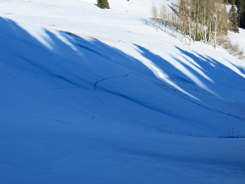
remotely triggered D1.5-2 in Purple Palace area on ascent, failure occurred at our same elevation, one small ridgeline over from our approach. We heard and felt the collapse/release. It ran at least 1500 feet, creating 6+ feet of debris. Roughly a 2 foot crown, wide propagation and shooting cracks above the failure. Also, this is the first prominent northerly slope running to the purple palace bench.
Weather:
Snowpack:
Photos:

Anthracite Avalanche – Remote trigger
Location: Kebler Pass Area
Date of Observation: 12/26/2017
Name: Chris Martin
Subject: Anthracite Avalanche – Remote trigger
Aspect: North
Elevation: 11,000′
Avalanches:
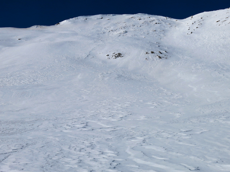
R4-D1.5-2 Remote Trigger from adjacent slope, lookers left of crown about a 20-30 meters away (see photo).
Weather: Partly Cloudy -2C. Light winds.
Snowpack: Not Recorded. Persistent slab ID’d on adjacent slope, 20 cm depth hoar at ground(N-NW), lookers left of crown .
Photos: