Upper Slate

CB Avalanche Center2018-19 Observations

Location: Paradise Divide Area
Date of Observation: 12/10/2018
Name: MR

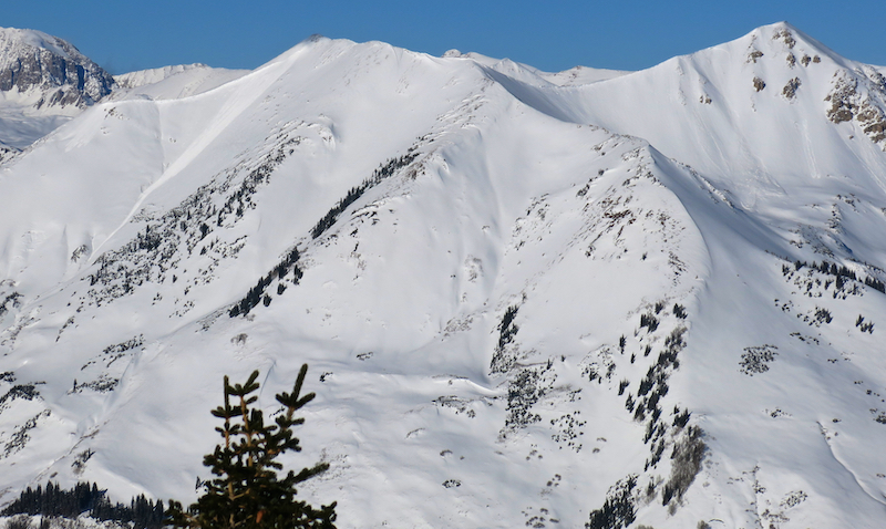
Subject: Upper Slate
Aspect: North East, East, South East
Elevation: 9,500-11,500

Avalanches:

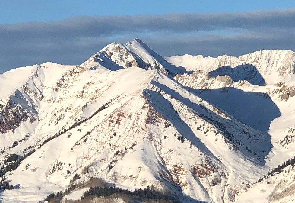
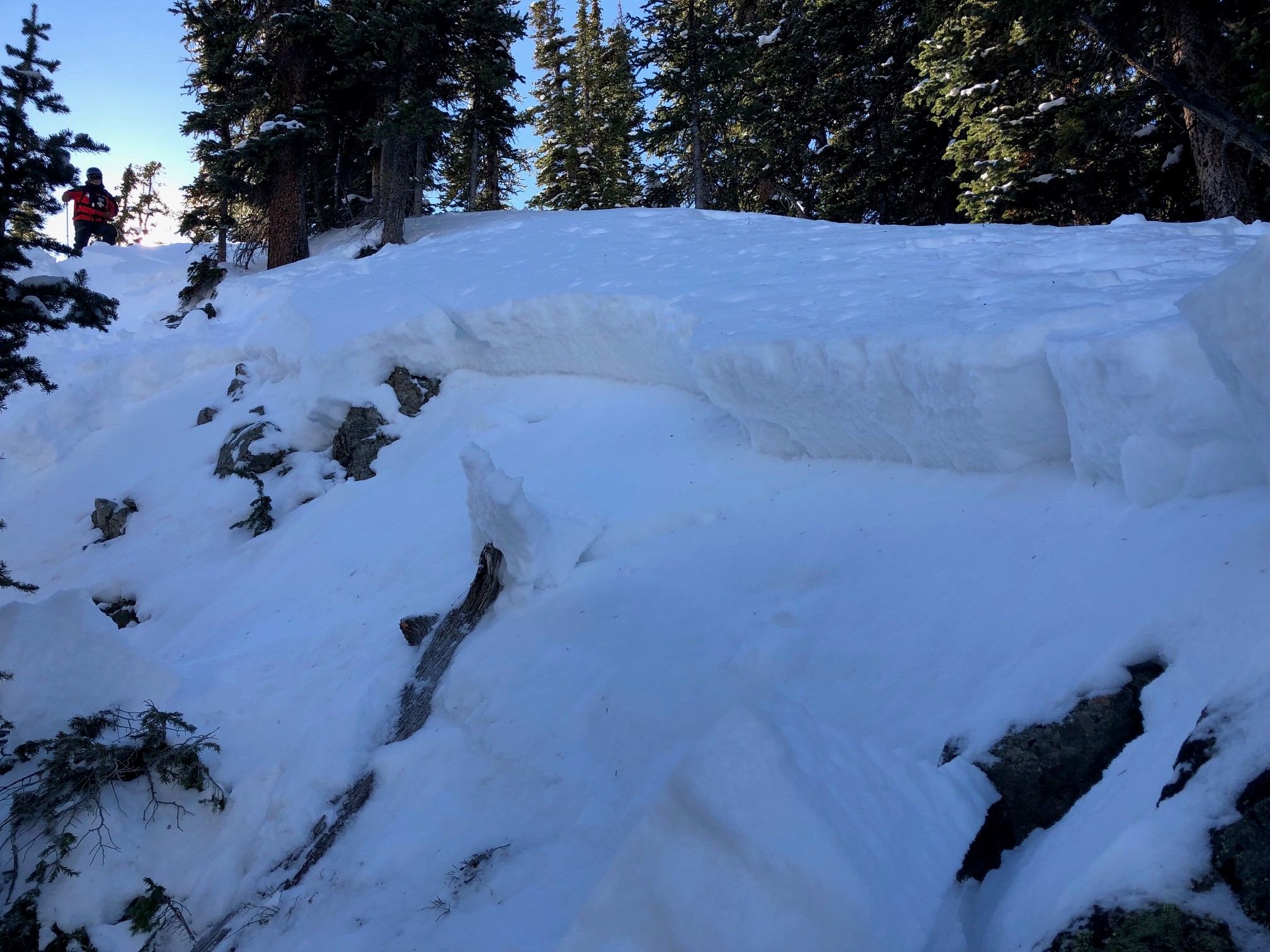
large avalanche on east face of Richmond and smaller one off angel pass, see photo.

Weather:
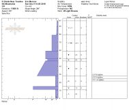
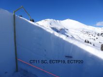
Snowpack: at 11,000 east facing, height of snow about 100cm. No instabilities observed, didn’t ski steeper than 30 degrees or so tho. Snow had gone thermal on any aspects that were at all southern tipped.

Photos:

Both slides already observed earlier in week (forecaster note)

SE face White Rock

CB Avalanche Center2018-19 Observations

Location: Crested Butte Area
Date of Observation: 12/10/2018
Name: Tom Schaefer

Subject: SE face White Rock
Aspect: South East
Elevation: 13,200′

Avalanches:

SE face White Rock Mt. observed from CBSP top shack.
N-R3-D3-O
This was observed from a great distance so the relative/destructive size is approx.. at this time.

Weather: Clear skies winds 17-26 mph out of the WNW from the Cinnamon Wx station. temps in the mid 20’s at that elevation.
Snowpack: N/O

Photos:

Post control release with ski cut

CB Avalanche Center2018-19 Observations

Location: Crested Butte Area
Date of Observation: 12/10/2018
Name: Crested Butte Ski Patrol

Subject: Post control release with ski cut
Aspect: East
Elevation: 11400

Avalanches:

ASu-R1-D.5-O.

Explosives had been thrown in the area nearby, on more southerly aspects affecting only new storm snow or wind slabs. The area subsequently ski cut had not been previously affected by traffic or explosives, and contained unique terrain features, acting as trigger points, that were linked by the ski cut. The resulting failure was not anticipated. No other results from ski cuts were observed on similar aspects or elevations.

Weather: Clear, mid-20’s, calm
Snowpack: Typically supportive mid pack, new snow & recent wind slabs reactive to explosives at depths of 6″-8″ were observed. Depth of snow at ski cut that triggered release was approximately 55-60cm. 6-8mm surface hoar observed near and above tree line on east through north facing aspects.

Photos:

Mountain Weather for 11,000ft

CB Avalanche CenterWeather

Date: 12/10/2018

For today, expect to see mostly sunny skies and temperatures to rebound nicely by warming close to the freezing mark. A weak ridge of high pressure will move across the area today but will pass quickly as clouds begin to build this afternoon and into the evening. Trailing just behind this ridge of high pressure is a trough that will bring light snow to the area on Tuesday. This system will move through quickly on Tuesday offering just a few inches of fresh snow. As soon as the first weak trough passes another low-pressure system will be following directly behind it and offer more light snow accumulations on Wednesday and into Thursday.

  • Today

    High Temperature: 25 to 30
    Winds/Direction: 2 to 12, WNW
    Sky Cover: Mostly Clear
    Irwin Snow: 0
    Elkton Snow: 0
    Friend’s Hut Snow: 0

  • Tonight

    Low Temperature: 10 to 15
    Winds/Direction: 2 to 12, WSW
    Sky Cover: Mostly Cloudy
    Irwin Snow: 0
    Elkton Snow: 0
    Friend’s Hut Snow: 0

  • Tomorrow

    High Temperature: 23 to 28
    Winds/Direction: 7 to 17
    Sky Cover: Mostly Cloudy
    Irwin Snow: 0 to 2
    Elkton Snow: 0 to 2
    Friend’s Hut Snow: 0 to 2

CBSPSP Hall of fame

CB Avalanche Center2018-19 Observations

Location: Crested Butte Area
Date of Observation: 12/09/2018
Name: Tom

Subject: CBSPSP Hall of fame
Aspect: North
Elevation: 11800

Avalanches:

First avalauncher round of the season. The first shot propagated aprx. 400′ . #2/3 no results. #4 propagated rapidly (shattered glass)
#1 AL-R2-D2.5-G
#4AL-R1-D2-G

Weather: Clear skis light winds NTL and Mod winds ATL from the NNW. Wind was transporting snow off the peak of Mt. CB throughout the day. 1-2 mm surface facets formed from the night before on N-W aspects own the ski hill.
Snowpack: Wind loading ATL forming specific terrain feature with wind slabs. On N aspects snow pack is continuing to weaken and facet.

Photos:

Snowpack still adjusting

CB Avalanche Center2018-19 Observations

Location: Kebler Pass Area
Date of Observation: 12/09/2018
Name: Cam

Subject: Snowpack still adjusting
Aspect: North, North East, South, South West
Elevation: 9-12.5 K

Avalanches:

One seemingly large avalanche on Axtel in 4th Bowl. Didn’t have a good enough view to notice any details. Clouds made it hard to see anything all day.

Weather: Light snowfall in the early AM. Felt humid. Winds generally calm except for above treeline. We didn’t see a lot of transport happening on the southern end of the forecast zone. Clouds came and went (mostly hung around) all day.
Snowpack: While skinning up a shady N aspect experienced numerous collapses between 10,000 ft. and 11,000 ft. Hand pit showed 65cm HS. Fairly consistent 4F all the way down to depth hoar on the ground. Collapsing stopped once the HS got deeper as we climbed, closer to 100-110 cms near and above treeline. Same structure existed, but no longer showed reaction to our weight.

Same exact thing happened on a different peak later in the day, but collapsing occurred both in and out of the trees.

South and Southwest aspects were more thin with no obvious signs of instability and a crust forming on the surface.

Photos:

Skiing and hole digging

CB Avalanche Center2018-19 Observations

Location: Paradise Divide Area
Date of Observation: 12/09/2018
Name: Eric Murrow

Subject: Skiing and hole digging
Aspect: North East, South West, West
Elevation: 11,000′ to 12,400′

Avalanches:

One very small, thin wind slab in east bowl on Baldy immediately below ridgetop.

Weather: Filtering low and midlevel clouds and sunshine. Winds near and above treeline were light with occasional drifting off the tallest and most exposed peaks and ridges. Air temps were cool, but solar radiation was strong enough to moisten slopes near 30 degrees or steeper that faced very close to south.
Snowpack: While traveling across steeper southerly slopes the snow surface became moist by midday even above treeline up to 12,400′.

Dug a profile on a northeasterly (51*) slope near tree line at 11,700′, HS 97cm, slope angle 24 degrees. Test results most notably showed CT 11SC on Thanksgiving interface, 2-3mm facets, ECTP 19 and ECTP20 on same facets. See photo below.

Photos:

Managing West for PSa

CB Avalanche Center2018-19 Observations

Location: Paradise Divide Area
Date of Observation: 12/09/2018
Name: Evan Ross

Subject: Managing West for PSa
Aspect: West
Elevation: 10,500-12,000

Avalanches:

Saw a small windslab run naturally in the afternoon at an ATL elevation, on a southerly slope above the 401 trail.

Weather: Mostly clear and generally light northwest winds. At ridgeline moderate gusts where just enough to drift snow. Drifting snow was happening mostly above the elevations we traveled.
Snowpack: Recreational pow day. Bottom line, traveled on westerly slopes with the same Persistent Slab terrain management that I would use on say, a northerly slope. You could easily feel the PS structure with your pole. We didn’t investigate further and managed our exposure for that problem. Skied to 35 degrees with no obvious signs to instability. Skied steeper slope angles on slopes that had previously avalanched this winter and had lost the PS structure. HS ranged from 80-100cm

Photos:

Snodgrass Tour

CB Avalanche Center2018-19 Observations

Location: Crested Butte Area
Date of Observation: 12/09/2018
Name: Avy 1 course

Subject: Snodgrass Tour
Aspect: North East
Elevation: 10,301

Avalanches:

Wet Loose on Gothic bottom of the spoon and looker right S/SE aspects
Wind Slab off peak of Gothic N/NE
Avery large dry loose S/SE aspect
multiple loose stuffs on red lady bowl

Weather: Temp: low 20’s
Sky: Clear
Wind: Light out of the NW
Precip: None
Snowpack: Pits
Aspect: NE
Elevation 10,301
HS: 84-72cm
Basel facets ranged 13cm-22cm

Tests :
CT11 SP & CT12 SC

Lots of cracks and collapses throughout our tour.

Photos:

Mountain Weather for 11,000ft

CB Avalanche CenterWeather

Date: 12/09/2018

A few snow showers and clouds will persist for the first part of the day over the western and northern part of the range from Irwin to Schofield. Snow showers are unlikely to produce much in the way of accumulation, but Irwin’s powcam is still showing very light flurries as of 5am. Wind speeds are forecasted to pick up today with speeds and gusts capable of transporting snow. Expect the clearing trend to last through Monday with the next small wave of moisture anticipated to push through the area on Tuesday offering a few fresh inches of snowfall.

  • Today

    High Temperature: 17 to 22
    Winds/Direction: 7 to 17, NW
    Sky Cover: Mostly Clear
    Irwin Snow: 0 to 1
    Elkton Snow: 0 to 1
    Friend’s Hut Snow: 0

  • Tonight

    Low Temperature: 5 to 10
    Winds/Direction: 0 to 10, WNW
    Sky Cover: Clear
    Irwin Snow: 0
    Elkton Snow: 0
    Friend’s Hut Snow: 0

  • Tomorrow

    High Temperature: 28 to 32
    Winds/Direction: 2 to 12, W
    Sky Cover: Partly Cloudy
    Irwin Snow: 0
    Elkton Snow: 0
    Friend’s Hut Snow: 0