Irwin Cat Ski Obs

CB Avalanche Center2018-19 Observations

Location: Kebler Pass Area
Date of Observation: 12/22/2018
Name: IG

Subject: Irwin Cat Ski Obs
Aspect:
Elevation:

Avalanches:

D1’s in Sunset L&R, Round 2, and Assassins.

Small shallow D.5 slow movers in Thornton’s Glade, JA Steep, Not 2 D.
Moonrise Right SS-ASc-R2-D1.5-S PP (20cm x 30m x 35m) Ski cut in moonrise right propagated into moonrise left

Weather: Snowy and Windy with gusty whiteout conditions in the am calming throughout the day. WSW winds though saw evidence of northerly swirling around in Robinson Basin.

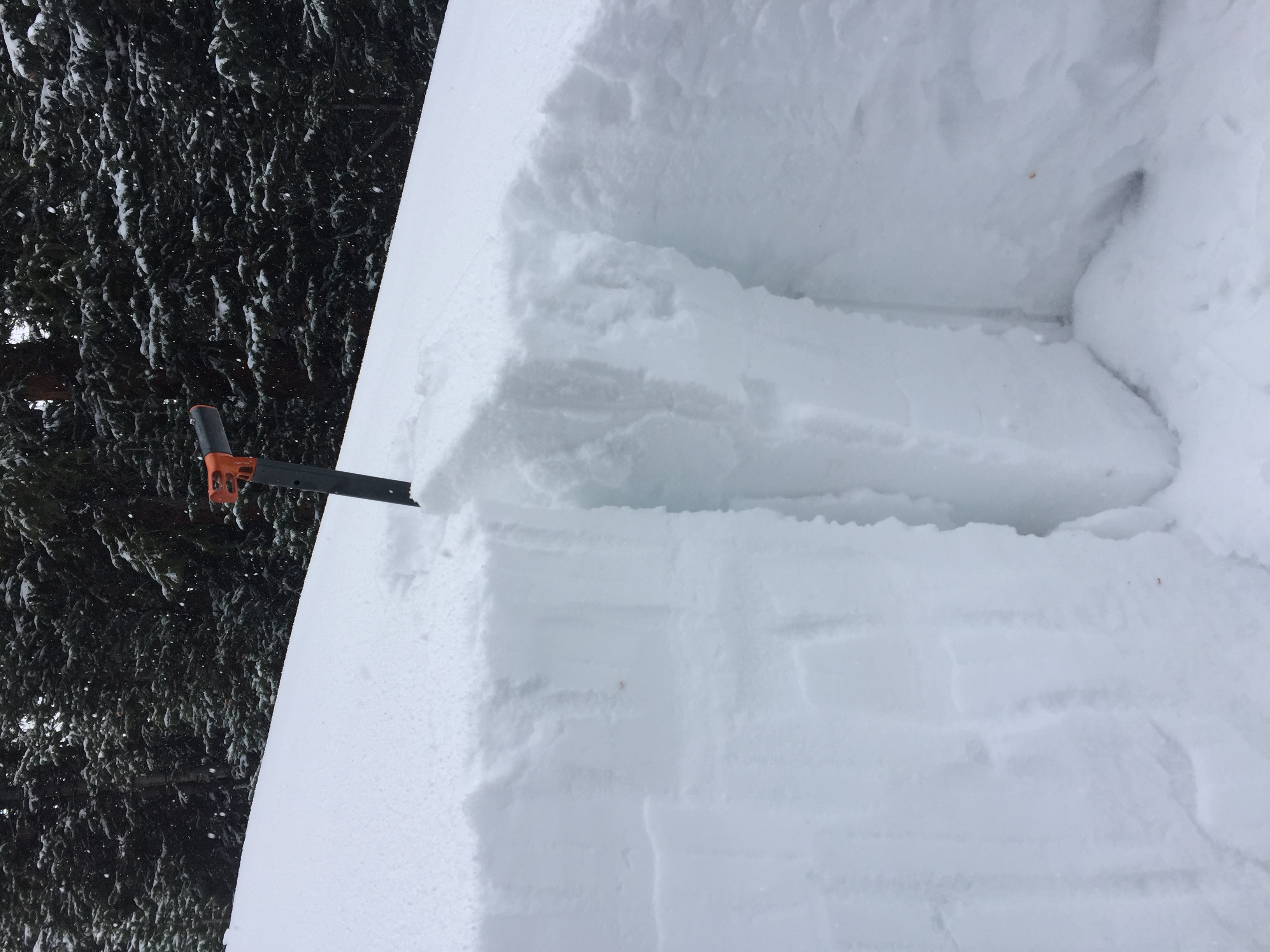
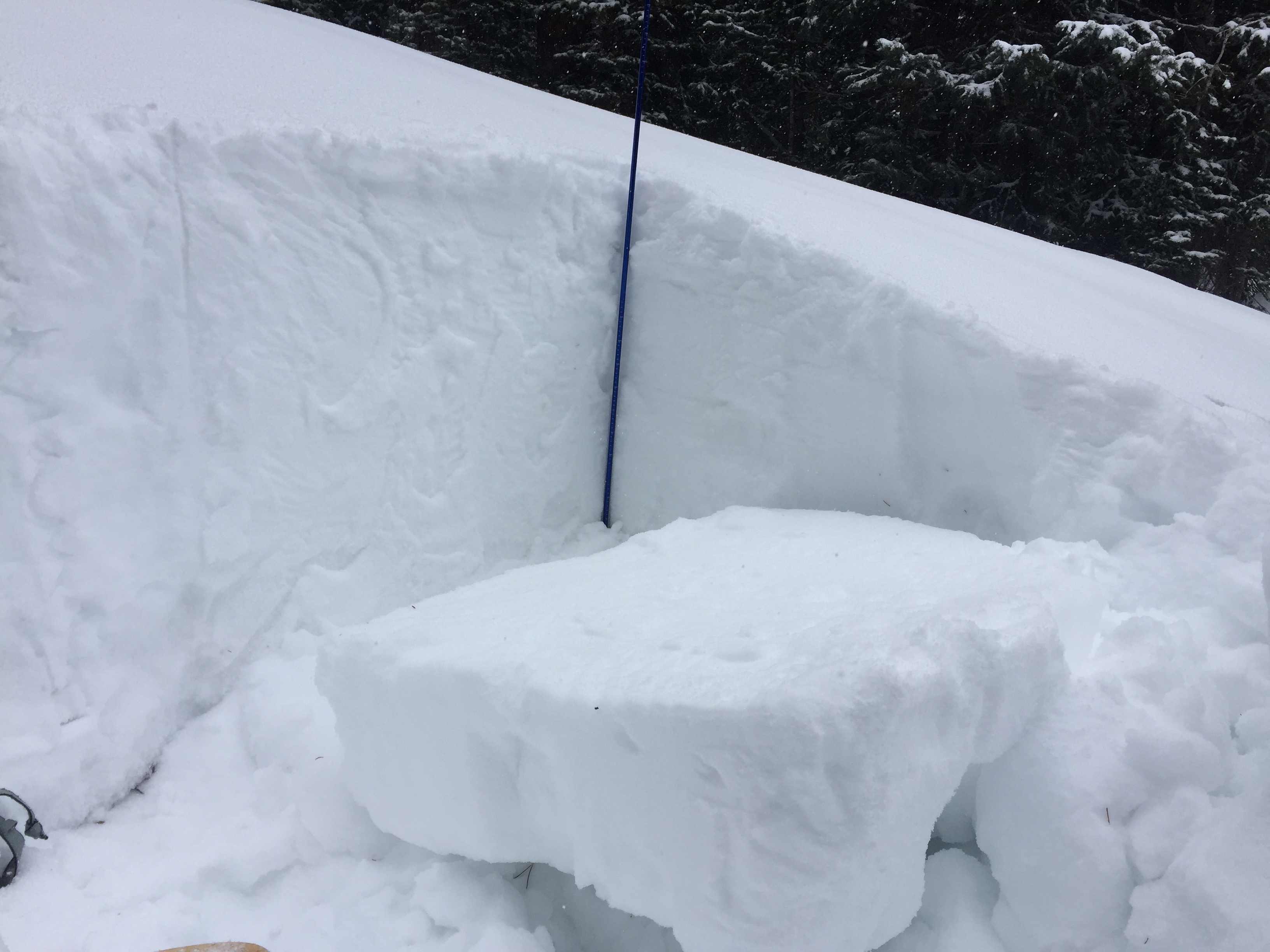
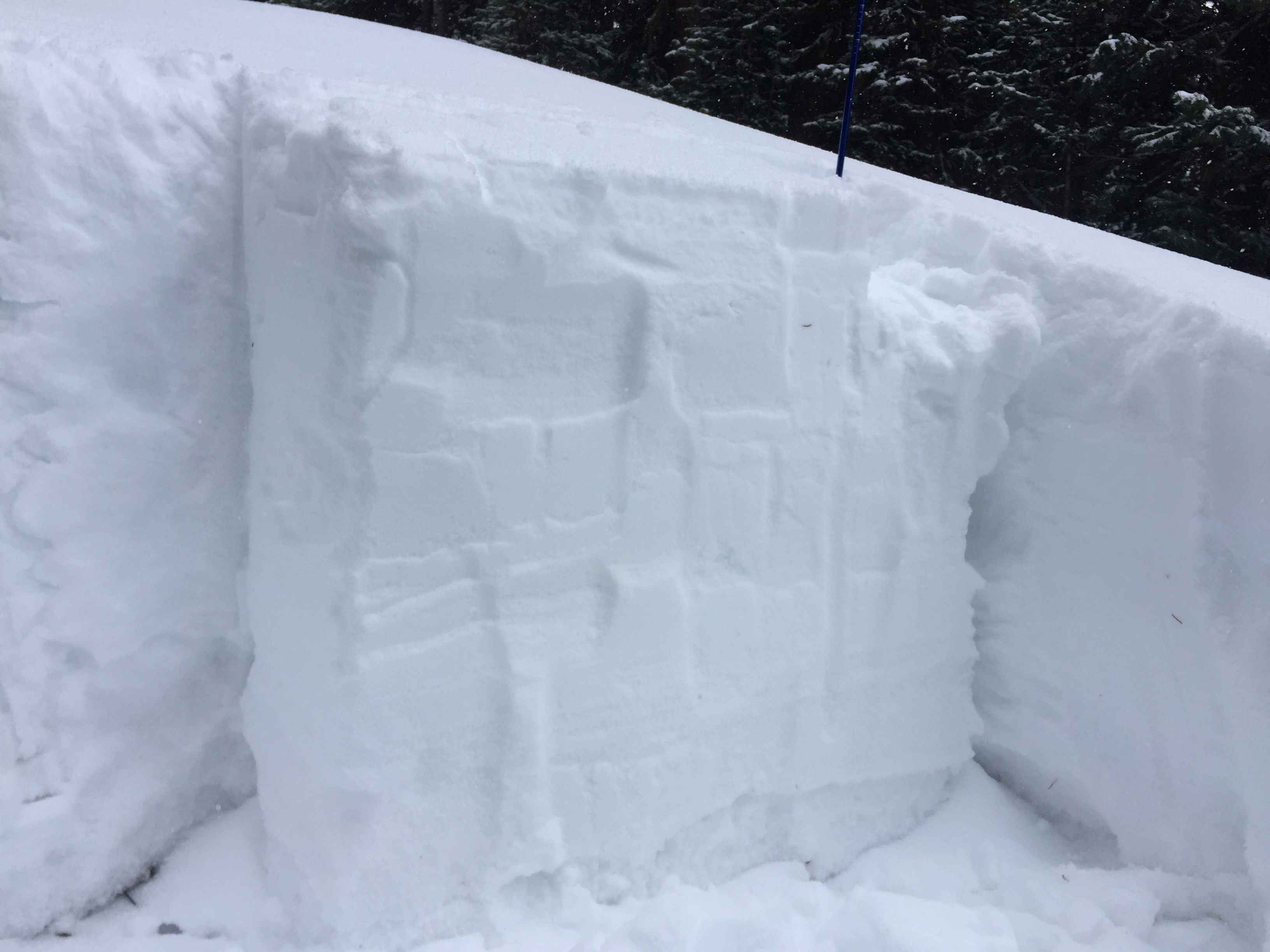
Snowpack: The wind picked up early morning and inverted the snowpack with denser snow above
lighter snow. The wind did a number this morning with scouring and drifting at all elevations. Widespread cracking and wind slab development. The Upper Westwall (Moonrise & Sunset) had 20-30cm wind slabs touchy and propagating wide with Several remote triggers. No obvious facets but all running on storm snow density
change. Round two below Moonrise and sunset very touch. Outer Limits shooting cracks but limited movement.
Surhan, Oswald, and Booth all cleaned out full width just stepping on top. Lower and mid west wall produced
cracking with much shallower results and less significant movement, though Thornton’s Glade still produced a
D1. Whiskey/Vodka Shots have a double crust in the top 20 cm’s from 12/19 & 12/21.

Photos:

Interface check-in

CB Avalanche Center2018-19 Observations

Location: Crested Butte Area
Date of Observation: 12/22/2018
Name: Zach Kinler

Subject: Interface check-in
Aspect: North, North East
Elevation: 9,200

Avalanches:

None Observed

Weather: Breezy NW winds in the open, snow showers up to S-2 before clearing skies.
Snowpack: Quick tour on lower Gunsight Pass Rd. Two recent interfaces have been buried and smaller storms are starting to build the slab especially North and West of town.

Pictures from this zone show the two layers @11cm and 17 cm from surface and the well-preserved nature of the 12/19 SH still upright and in tact.

Photos:

AMR

CB Avalanche Center2018-19 Observations

Location: Kebler Pass Area
Date of Observation: 12/22/2018
Name: Joey Carpenter

Subject: AMR
Aspect: North, North East, East
Elevation: 10200-11400

Avalanches:
Weather: Skies varied between broken and overcast, intermittent snowfall with rates up to S5 and 2-3 inches accumulation throughout the day. Winds averaged in the mid-twenties, gusts in the 30s out of the NW->N and strong snow transport. Cold.
Snowpack: Last nights accumulation 4 inches with 2-3 more throughout the day. Wind was transporting snow into thin, stiff windslabs in some areas we traveled. Soft, small storm slabs (D.5) were reactive in isolated, rolling terrain steeper than 35 degrees.

Photos:

Weakness under Windslab at Snodgrass test pit

CB Avalanche Center2018-19 Observations

Location: Crested Butte Area
Date of Observation: 12/22/2018
Name: Aaron Peterson

Subject: Weakness under Windslab at Snodgrass test pit
Aspect: North
Elevation: 11,100

Avalanches:

Lots of sluffing in the top 10cm of new snow on the decent. Nothing else noted.

Weather: Overcast, light snow with occasional graupel, low 20s F, strong west winds in the open and at tree-tops but calm in the trees.
Snowpack: Found a prominent wind-loaded feature on 20deg, north-facing terrain near the top of First Bowl on Snodgrass. Likely formed on 12/19.

HS 90cm with 10cm of new snow on top of a 15cm windslab on top of 4F-1F midpack. 15cm of faceted snow still present at ground level.

ECT 21, Q3. Failed on top of the basal facets. Same result on second test. Shovel shear failed at same level with moderate pressure.

Photos:

Gothic 7am Weather Update

CB Avalanche Center2018-19 Observations

Location: Paradise Divide Area
Date of Observation: 12/22/2018
Name: Billy Barr

Subject: Gothic 7am Weather Update
Aspect:
Elevation:

Avalanches:
Weather: Light snow after dark but most came a bit before sunrise, letting up when the wind kicked up around 5:30. There has been 3″ new snow and water of 0.20″ with 23½” on the ground. Temperature stays mild with the overnight low 21 and currently 24. Wind became strong near 6 a.m. and is gusting to 25 mph currently and a steady 5-15 W.
Snowpack:

Photos:

Mountain Weather for 11,000ft

CB Avalanche CenterWeather

Date: 12/22/2018

Snow began to fall yesterday afternoon around Irwin at 2 pm and tapered off last night, but early this morning snowfall is picking back up. As of 5 am, areas to the west of Crested Butte have picked up around 5″ new but CBMR is sitting at a measly 1″. Areas to the west and north of town, per usual, will do best. Today you can expect snowfall for the first half of the day, around 2 to 5 additional inches, and diminish throughout the afternoon. Snowfall will stop by the evening. Immediately on the heels of today’s quick disturbance is a second shortwave trough slated to push through the area during midday tomorrow offering a few more inches of accumulation on Sunday. Looking ahead it looks like a significant Pacific system will begin to impact the region beginning on Christmas Day. Whoop Whoop! We are back in the snow!

  • Today

    High Temperature: 20 to 25
    Winds/Direction: 12 to 22, W
    Sky Cover: Mostly Cloudy
    Irwin Snow: 2 to 5
    Elkton Snow: 2 to 5
    Friend’s Hut Snow: 2 to 5

  • Tonight

    Low Temperature: -2 to 3
    Winds/Direction: 7 to 17, W
    Sky Cover: Mostly Clear
    Irwin Snow: 0
    Elkton Snow: 0
    Friend’s Hut Snow: 0

  • Tomorrow

    High Temperature: 20 to 25
    Winds/Direction: 10 to 20, W
    Sky Cover: Mostly Cloudy
    Irwin Snow: 0 to 2
    Elkton Snow: 0 to 2
    Friend’s Hut Snow: 0 to 2

Mountain Weather for 11,000ft

CB Avalanche CenterWeather

Date: 12/21/2018

Get out of here you lumpy dry ridge from yesterday, and come on in water vapor that wants to turn into snowflakes! Moisture is streaming into Colorado this morning and will bring high clouds for the day. We’ll see this moisture start to turn into snowflakes late this afternoon with a chance to pick up an inch or two before midnight. Next in line is a shortwave trough cutting across the northern half of Colorado on Saturday. This shortwave will bring 3 to 6″ of snow by Sunday Morning! Yea Baby. Saturday night into Sunday will dry out a bit. Then it all happens… CBAC has launched it’s Santa Makes Winter Great Again campaign and Santa has jumped on board! With no border walls to cross to the north, there is an open door for Santa to bringing a couple storms and one big closed low down with him next week. We are looking ahead to an unsettled and stormy holiday week. I’m so happy.

  • Today

    High Temperature: 28
    Winds/Direction: 10 to 20 W
    Sky Cover: Mostly Cloudy
    Irwin Snow: 0 to 1 PM
    Elkton Snow: 0 to 1 PM
    Friend’s Hut Snow: 0 to 1 PM

  • Tonight

    Low Temperature: 18
    Winds/Direction: 10 to 2 W
    Sky Cover: Overcast
    Irwin Snow: 1 to 3
    Elkton Snow: 1 to 3
    Friend’s Hut Snow: 0 to 2

  • Tomorrow

    High Temperature: 25
    Winds/Direction: 10 to 20 West
    Sky Cover: Overcast
    Irwin Snow: 2 to 4
    Elkton Snow: 2 to 4
    Friend’s Hut Snow: 2 to 4

P-Divide sunny alpine

CB Avalanche Center2018-19 Observations

Location: Paradise Divide Area
Date of Observation: 12/20/2018
Name: Eric Murrow

Subject: P-Divide sunny alpine
Aspect: South East, South, South West, West
Elevation: 10,800 – 12,450

Avalanches:

One fresh looking avalanche (crown still pretty sharp) on a westerly terrain feature that gets loaded from northerly winds. D1 in size

Weather: Lots of sun with thin high clouds filtering the sunlight. Light winds through late morning and early afternoon; as we left the area around 1pm winds began to blast snow around in the alpine- did not look like much loading just a blustery mess.

Snowpack: On ascent, we crossed a westerly slope near treeline that I had crossed about a week ago and found that it had weakened during this period and didn’t seem to have as much strength – ski pen was deeper than a week earlier. Surface on this west slope was still dry without a sun crust present.

Much of the alpine terrain visible from up high looked scoured and beat up from the previous days wind event.  I bet there were a few small, fresh, thin windslabs out there tucked behind terrain features like the one pictured below. Skied a south facing slope that had 2-4 inches of new snow resting on a semi-supportive crust. Skied through the drifty looking SE facing feature in the area and did not find a windslab. Looks like the wind blew the snow further downslope or into the basin below. At around 11,200 in the basin found a small isolated strip of deposited snow up to about 10″ thick-not avalanche terrain but made for about 10 quality turns.

Photos: