Windslab Sensitivity in Evan’s Basin and Red Lady Glades

CB Avalanche Center2018-19 Observations

Location: Kebler Pass Area
Date of Observation: 01/26/2019
Name: James Bivens

Subject: Windslab Sensitivity in Evan’s Basin and Red Lady Glades
Aspect: South East, South, South West
Elevation:

Avalanches:

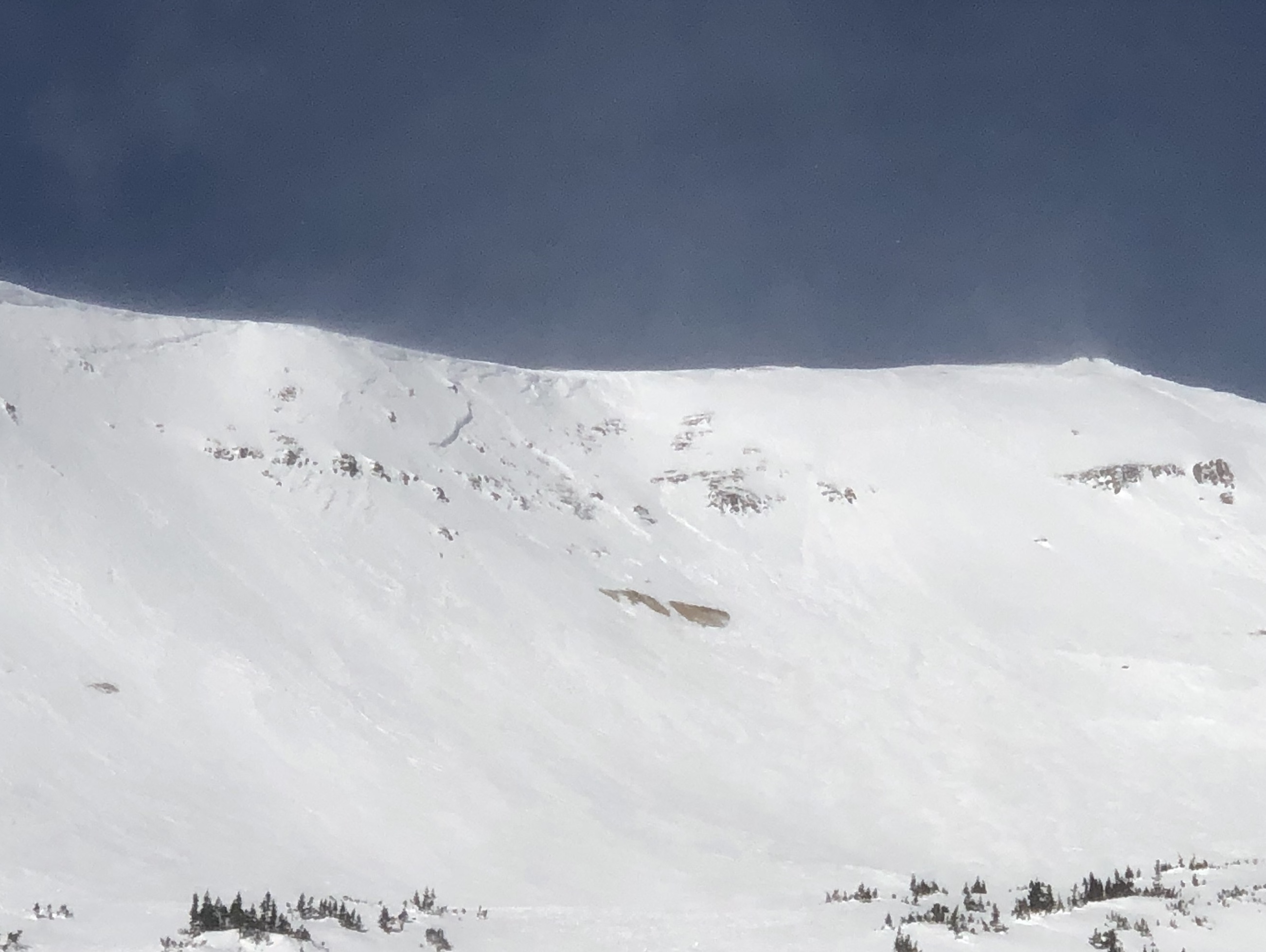
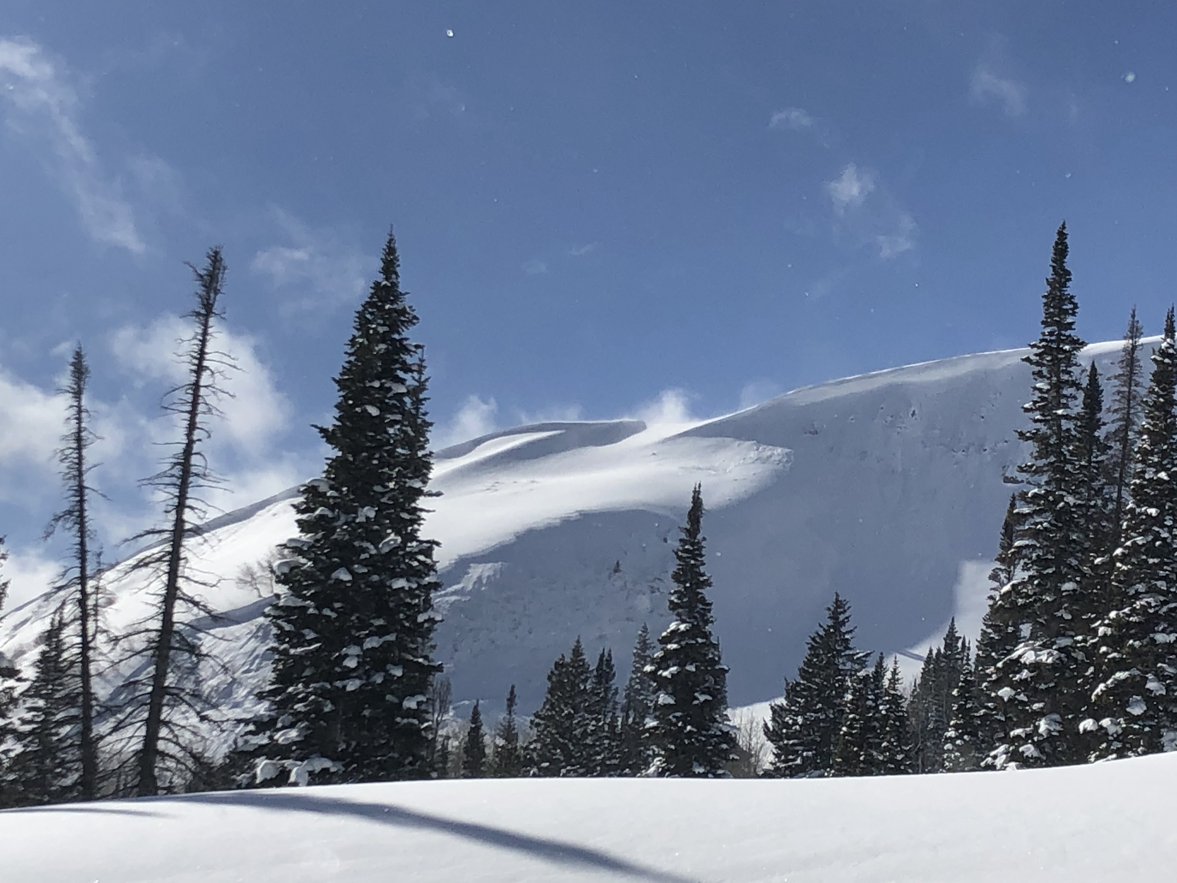
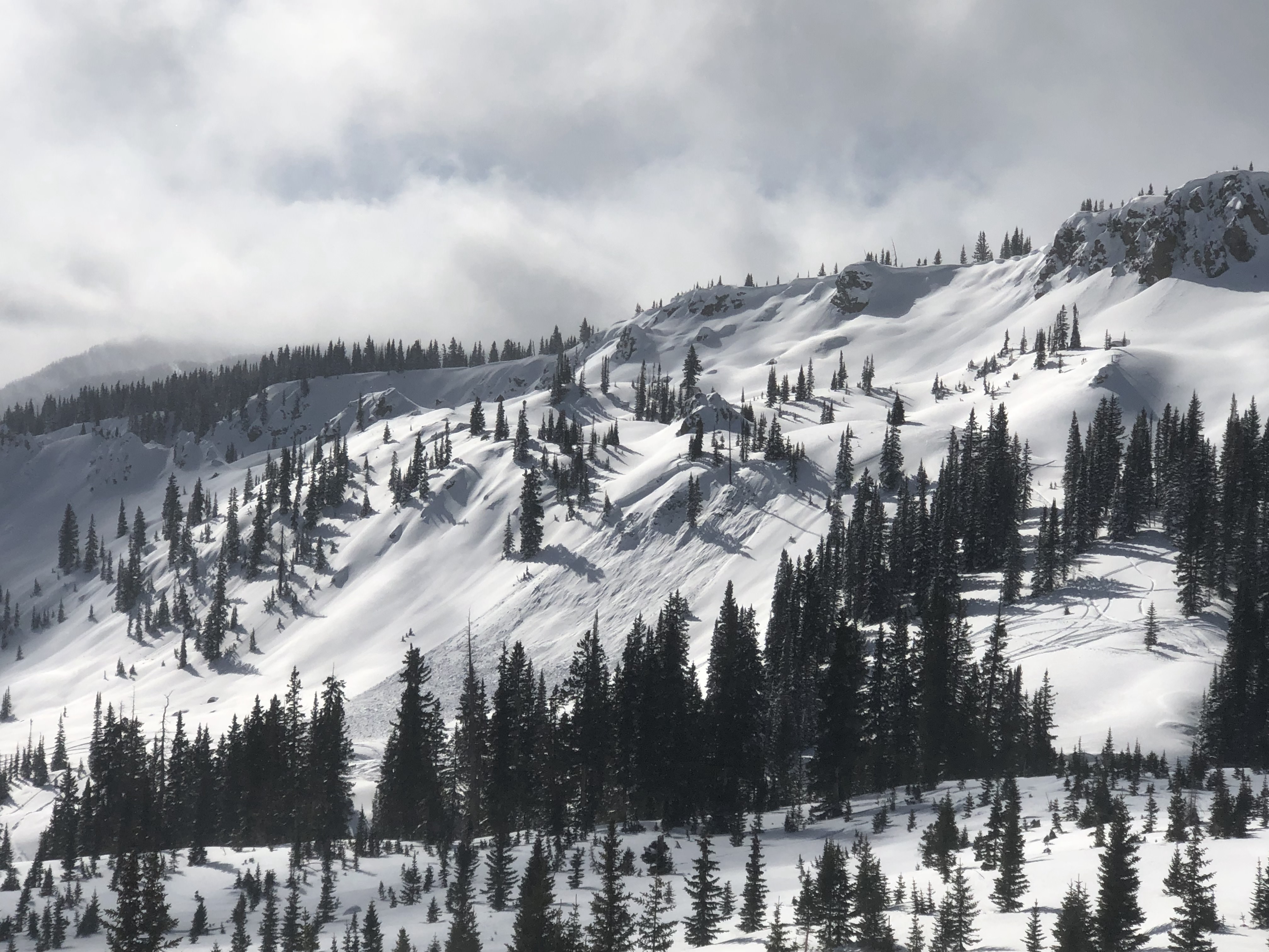
The top eastern face of Evan’s basin had a few older looking avalanches. Lower down, we observed a D2 avalanche on the eastern aspect of Evan’s Basin below treeline that appeared to have been remotely triggered by sleds. We didn’t see the party and the slope appeared to have been heavily wind-loaded. We also observed another similarly sized avalanche lower down on the same eastern aspect; this one appeared to have ran naturally after wind-loading. We also noticed some reactivity on the final (steeper) pitch before the road when we triggered a little windslab.

Weather: Sunny and super windy above treeline and moderately windy below treeline (even down to Kebler Pass where we received some helpful pushes from the wind while skating back to the trailhead). Further north and west there appeared to be a mix of more wind and lower hanging clouds (for example, we could not see Mt. Owen clearly from the summit of Red Lady).

Snowpack: The snowpack felt supportive with no collapses or shooting cracks (except for the little windslab below.) The skiing was lovely in dense, soft snow, but there were patches of snow in direct sunlight at lower elevations that were starting to heat up (before potentially refreezing into crusts tonight).
Photos:

Red Coon Glades

CB Avalanche Center2018-19 Observations

Location: Crested Butte Area
Date of Observation: 01/26/2019
Name: CBC AIARE Level 2 course

Subject: Red Coon Glades
Aspect: South East, South
Elevation: 9,200′ – 11,300′

Avalanches:

Viewed several fresh avalanches, the Evans basin slides were reported by a previous ob, but not sure from their ob if the saw all of these.
Evans Basin-East, D2 x 3 – from a distance looked to be 2 to 3 feet deep.
Axtel- NE, D1.5 – view at oblique angle, several old crowns above and what appeared to be freshish crown that was several feet deep but narrow

Weather: Left trailhead at about 12ish and this time winds were honking at the parking lot, blowing and drifting. Winds continued throughout the tour, but were lighter at our protected location until we reached more open near treeline terrain. Drifting and transport were visible above treeline on Axtel, Coon, and Redlady throughout the tour. Winds appeared to be drifting out of NW – N and depositing snow onto southern and eastern portions of the compass. Looked like snow was being blown lower into start zones.

Snowpack: Investigated snowpack on a near treeline SE slope. HS ranged between 120 – 150cm with somewhere near 140 being average. Of note was a buried SH layer down 30 to 45cm, we poked a couple of holes. The 1/15 crust was down around 55-60cm (this was a crust/facet/crust sandwich). Test results were CTN and ECTX. Foot pen. about 35cm and ski pen about 15cm. No cracking or collapsing

Photos:

Remote Trigger, Relentless NW winds

CB Avalanche Center2018-19 Observations

Location: Paradise Divide Area
Date of Observation: 01/26/2019
Name: Joey Carpenter

Subject: Remote Trigger, Relentless NW winds
Aspect: South, South West, West
Elevation: 9600-11900

Avalanches:

ESE aspect initiating at 11.8k. This was a heavily windloaded slope. We were intentionally staying connected to this terrain feature (on the low angle ridgeline) and searching for shallow spots in the spx as we ascended since we knew the adjacent slopes were suspect. We got a small collapse at 11.7k (noted above) and didn’t think it propagated very far. However, as we ascended ~100 feet more, we saw the fresh debris pile of our remote trigger. This was an R1D2 slide that remote triggered from approximately 200 linear feet away around a terrain feature. The steepest part of the crown was on an approximated 37 degree slope. The crown did prop onto much lower angle terrain though. The slide was approximately 450 feet wide and ran 300 vertical feet. there were chunks of debris approximately 4x4x4ft at their largest. We did not inspect the bed surface as there was substantial hang fire above and we were unable to safely approach the crown.

Weather: Temperatures remained cold, very comfortable hiking temperatures. Sustained NW winds transported snow from high and mid elevation ridges throughout the day. Above 11k the western ridges are becoming scoured. Substantial wind effect on multiple aspects and elevations. The western part of the forecast area maintained clouds throughout our tour and they became thinner and less pronounced as you moved east across the zones. Solar intensity approached moderate for a few short periods during the day. However, cool temps and sustained winds kept snow surfaces cold.

Snowpack: We had two notable collapses on our tour. One at 11.1k on a 25 degree SSW facing slope while skinning, medium sized. Snowpack depth on this windloaded terrain feature was an average of 175cm. Did not dig to find the failure layer. The other collapse was at 11.7k on a S facing aspect and remotely triggered the avalanche described below.

Photos:

Fresh Baldy and WSC Avalanches

CB Avalanche Center2018-19 Observations

Location: Paradise Divide Area
Date of Observation: 01/26/2019
Name: Tom Schaefer (CBPSP)

Subject: Fresh Baldy and WSC Avalanches
Aspect: East, South East, South, South West
Elevation: ATL/NTL

Avalanches:

Fresh avalanches this afternoon observed from ski area.

Snodgrass-Freshened up

CB Avalanche Center2018-19 Observations

Location: Crested Butte Area
Date of Observation: 01/26/2019
Name: ADB

Subject: Snodgrass-Freshened up
Aspect: East
Elevation: BTL

Weather: Clear skies, cold temperatures, and moderate winds with no snow transport. Observed sustained NW winds blowing snow from top of Whetstone on drive to the trailhead and back.

Snowpack: Most tracks filled in between first bowl and third bowl. Snow was very supportive with a fresh coat of wind deposited snow, forming a 2 to 4 inch layer of soft wind slab.

Cement Creek-Recon

CB Avalanche Center2018-19 Observations

Location: Cement Creek Area
Date of Observation: 01/26/2019
Name: ADB

Subject: Cement Creek-Recon
Aspect: West
Elevation: BTL-Valley Bottom

Weather: Clear skies and light winds.

Snowpack: Poking around with ski pole and digging with hands:
HS is less than 27 inches.
snow is variable between supportive and unsupportive with a few complete collapses on a buried bedrock shelf.
very qualitative and subjective:
22 inches to surface-Fist hardness
12-21 inches: 4F hardness
10-12 1F hardness
0-10 inches F hardness and full of faceted grains.

AIARE 1 Group 2 Gothic RD

CB Avalanche Center2018-19 Observations

Location: Crested Butte Area
Date of Observation: 01/26/2019

Subject: Irwin AIARE 1 Group 2
Aspect: South East
Elevation: 10,200

Weather: clear
10mph winds

Snowpack: 18 degrees
CT26 and CT27
ECTX

(HS on the gothic road pit I just submitted was 126cm)

AIARE 1 Group 3 Red Lady Glades

CB Avalanche Center2018-19 Observations

Location: Kebler Pass Area
Date of Observation: 01/26/2019

Subject: Irwin AIARE 1 Group 3
Aspect: East
Elevation: 10,200

Weather: Few Clouds
10mph at pit
15mph at cars

Snowpack: Red Lady Glades
E
CTX

AIARE 1 Gothic RD

CB Avalanche Center2018-19 Observations

Location: Crested Butte Area
Date of Observation: 01/26/2019

Subject: Irwin AIARE 1
Aspect: North East
Elevation: 9,600

Weather: Gothic Road
Sky cover- Few
10 mph winds (picking up around 2 pm)

Snowpack: CT 19 20cm
ECTX X2
Poor Man’s Rouchblock https://youtu.be/vXbxlWDmVE8

Ski Pen 15 cm
Boot Pen 45cm
Both images uploaded are facets at 20 cm 1-2mm rounding facets

Photos:

Mountain Weather for 11,000ft

CB Avalanche CenterWeather

Date: 01/26/2019

Compared to the last week or so, today’s weather and beyond is a bit of a yawner. Not going to belabor the bottom line. Last nights very weak wave of embedded moisture than dropped a skiff on the northern Elks dries up. High and dry ridge of high-pressure slides overhead, as it does, we could get one more shot of light snow tomorrow. Bit of a breather for the weak ahead, model agreement diverges for the end of this week, 6 days out. Potential moisture, but lots of time to let some snow do some settling in the meantime. Expect valley inversions to strengthen.

  • Today

    High Temperature: 10-15
    Winds/Direction: 15-25/NNW G40
    Sky Cover: Partly Cloudy
    Irwin Snow: 0-1″
    Elkton Snow: 0-1″
    Friend’s Hut Snow: 0-1″

  • Tonight

    Low Temperature: 8-12
    Winds/Direction: 5-15/NW
    Sky Cover: Mostly Cloudy
    Irwin Snow: 0
    Elkton Snow: 0
    Friend’s Hut Snow: 0

  • Tomorrow

    High Temperature: 20-25
    Winds/Direction: 10-20/NW
    Sky Cover: Mostly Cloudy
    Irwin Snow: 0-1″
    Elkton Snow: 0-1″
    Friend’s Hut Snow: 0-1″