




Location: Cement Creek Area
Date of Observation: 12/13/2019
Name: Cosmo
Subject: Cement Creek New Snow
Aspect:
Weather: Cement Creek @ 9400’- 5.5” new snow as of 5am FridayLocation: Cement Creek Area
Date of Observation: 12/13/2019
Name: Cosmo
Subject: Cement Creek New Snow
Aspect:
Weather: Cement Creek @ 9400’- 5.5” new snow as of 5am FridayLocation: Crested Butte Area
Date of Observation: 12/13/2019
Name: billy barr
Subject: Gothic Townsite 6am Obs
Aspect:
Elevation: 9400Date: 12/13/2019
A complicated, multi-stage storm will drop significant snow accompanied by strong westerly winds today through tomorrow. A well defined stream of moisture with origins near Hawaii will arc over Northern California and slam into the Elk Mountains riding a 170-200kt jet (impressive!) today, with models showing the heaviest snowfall early Saturday morning. Today, light snow will generally continue, with areas near Kebler and Schofield Passes will seeing the most steady orographic snow continue most of the day. Around sunset, snowfall with taper, before the next wallop arrives Friday night into Saturday. West-Northwest winds will continue to gust into the 40-50mph range above timberline throughout this event. Temperatures will remain quite mild in the mid to upper 20s and may even even rise into the lower 30s with the the moister airmass tomorrow. Today, look for daytime snow accumulations less than 6”, but the main event Friday night into Saturday should not disappoint. Total storm snow accumulations look to easily exceed 20” across the high terrain surrounding Crested Butte by Sunday morning.
High Temperature: 20-25
Winds/Direction: 20 G40-50/WNW
Sky Cover: Mostly Cloudy
Irwin Snow: 3-6″
Elkton Snow: 3-6″
Friend’s Hut Snow: 2-4″
Low Temperature: 20-25
Winds/Direction: 20 G40-50/WNW
Sky Cover: Mostly Cloudy
Irwin Snow: 4-8″
Elkton Snow: 4-8″
Friend’s Hut Snow: 3-6″
High Temperature: 25-30
Winds/Direction: 25 G50-60
Sky Cover: Mostly Cloudy
Irwin Snow: 4-8″
Elkton Snow: 4-8″
Friend’s Hut Snow: 3-6″
Location: Paradise Divide Area
Date of Observation: 12/12/2019
Name: Zach Kinler
This week saw multiple storms and avalanche cycles as well as an expanding persistent slab problem. Track all that and more by reading the full summary here.
Date: 12/12/2019
We have another cold morning. Partly cloudy sky overnight helped those low temps again drop down to near 0 in the valleys and the low teens in the mountains. A Pacific river of moisture has made its way into the US and will give us a nice spray here in Colorado to close out the week. Clouds will be thickening on Thursday with some light snowfall late this afternoon. Then the action gets going on Thursday Night into Friday Morning. The snowfall ramps up on Thursday night, and by Friday morning we’ll have, good available moisture, good upper-level jet support, and WNW orographics kicking in. This all should line up for some heavy pulses of snow on Friday morning. The wind speeds will also be elevated during this time so get ready for some real winter storm conditions during the early AM hours of Friday.
The hose of moisture streaming into Colorado looks to falter a bit for a period of time on Friday. If this happens we’ll see an associate lull in snowfall. That moisture stream then realigns Friday Afternoon and into Saturday with an even better round of snow. By Sunday the moisture currently looks to sag south of our area, otherwise, we could see snow continue towards the end of the weekend if that moisture stays further north in later forecast model runs.
High Temperature: 24 to 28
Winds/Direction: 10 to 20, West
Sky Cover: Mostly Cloudy
Irwin Snow: 0 to 2
Elkton Snow: 0 to 2
Friend’s Hut Snow: 0 to 2
Low Temperature: 16 to 20
Winds/Direction: 15 to 25 G40, West
Sky Cover: Overcast
Irwin Snow: 5 to 8
Elkton Snow: 5 to 8
Friend’s Hut Snow: 4 to 7
High Temperature: 20 to 24
Winds/Direction: 10 to 20, West
Sky Cover: Mostly Cloudy
Irwin Snow: 2 to 4
Elkton Snow: 1 to 3
Friend’s Hut Snow: 1 to 3
Location: Paradise Divide Area
Date of Observation: 12/10/2019
Name: Lawson
Subject: Baxter basin obs
Aspect: East, South East, South
Elevation: 10-12Small pocket soft slabs on E facing terrain. Releasing inches deep w no propogation wider than ski.
Weather: Cold. High wispy clouds Snowpack: Deep! 1-2 meters HSDate: 12/11/2019
Ok, I want to talk quickly about today so we can move on to the snow baby! This morning valley low temperatures are again below zero while 11,000ft temperatures are in the high teens. Wind-speeds have decreased overnight and look to stay down for today. Upper-level moisture starts increasing this afternoon and we’ll see that with increasing clouds. Enough of that? Let’s move onto the snow part.
Thursday afternoon into the Friday AM hours is looking good for the snow bits. Westerly flow will bring a moisture tap stretching out to Hawaii. That moisture is looking good at both 500mb and 700mb during the above timeframe. In my perfect world, it could drop a bit further south and stay more consistent, but never the less we’ll have the stuff snowflakes are made of. The atmosphere will further be unstable and we’ll have strong winds aloft. So we are shaping up good. To call a foot of snow for this time period may be a bit dreamy at the moment, but it should stack up never the less. Dryer air moves in later on Friday, then more snow looks to be in the forecast for Saturday!
High Temperature: 20 to 24
Winds/Direction: 5 to 15, W
Sky Cover: Increasing clouds
Irwin Snow: 0
Elkton Snow: 0
Friend’s Hut Snow: 0
Low Temperature: 14 to 18
Winds/Direction: 5 to 15, W
Sky Cover: Mostly Cloudy
Irwin Snow: 0 to 1
Elkton Snow: 0 to 1
Friend’s Hut Snow: 0 to 1
High Temperature: 24 to 28
Winds/Direction: 10 to 20, W
Sky Cover: Mostly Cloudy
Irwin Snow: 0 to 2
Elkton Snow: 0 to 2
Friend’s Hut Snow: 0 to 2
Location: Brush Creek Area
Date of Observation: 12/10/2019
Name: Eric Murrow
Subject: West Brush Creek
Aspect: East, South, South West
Elevation: 9000′ to 11450′
Avalanches: Gothic: 2xSS-R1-D2 large avalanche on “spork” and east face
Baldy: 1xSS-R2-D2 large avalanche on an alpine east face
WSC: 2xSS-R2-D2 SE alpine terrain features
Weather: Clear skies, mild temperatures, and light winds in terrain traveled. No significant loading but occasional drifting at highest terrains near peaks,.
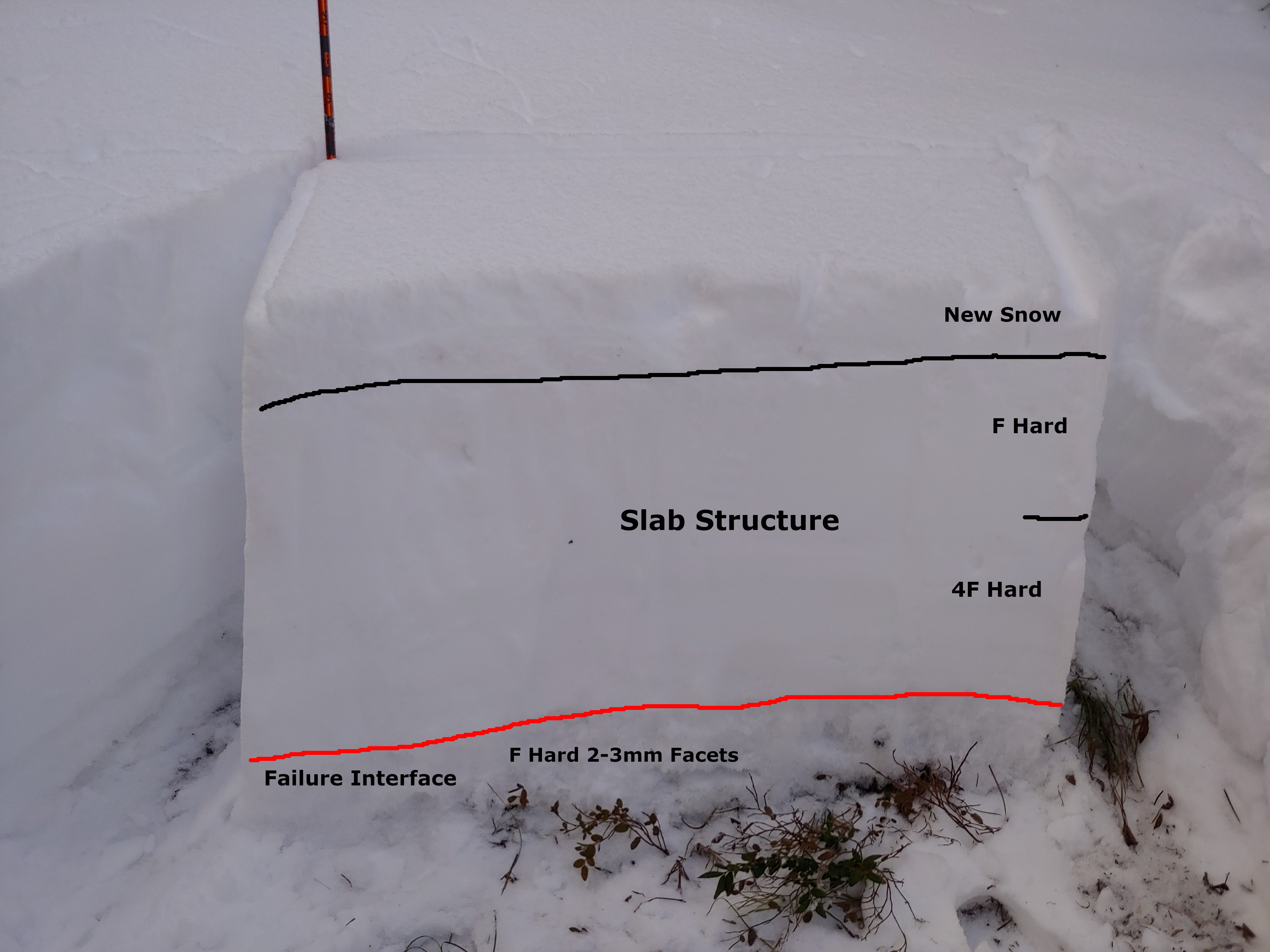
Snowpack: Traveled up onto Teo ridge from West Brush Creek looking at slab structure to the east of Crested Butte. Profile dug in an east-facing meadow at 11,200′ found HS 78cm with cohesive slab resting above old, weak facets at the ground. Test results CTV and ECTP16. This structure produced numerous rumbling collapses in nearby areas. HS on south and southwest facing near and below treeline was around 40cm. Southerly terrain produced collapses as well but not nearly as large as east-facing terrain. Southerlies had a double crust with facets beneath. South-facing slopes below treeline had become moist by the afternoon. Poor looking structure in most terrain traveled. HS at 9900′ in valley bottom below Teocalli was around 5ocm.


Location: Paradise Divide Area
Date of Observation: 12/10/2019
Name: Sam Roberts
Subject: Coneys
Aspect: North, North East, East
Elevation: 9600′-10380′Saw a small point release slide in Coon Basin on Mount Emmons N aspect R1D1
On the way to Coneys we saw R1.5 D2 on the South side of Mount Baldy around 12000′
Photos:
Location: Kebler Pass Area
Date of Observation: 12/10/2019
Name: Evan Ross & Zach Kinler
Subject: Recent Natural Avalanches
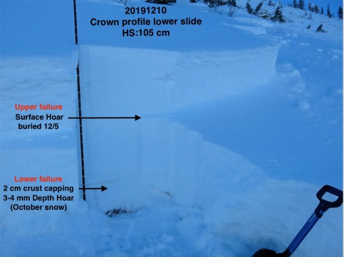
Several fresh natural avalanches were observed on 12/10 thanks to the mostly clear sky and good light. Some of these avalanches looked very fresh and may have released during the AM hours of 12/10. Most avalanches in this natural cycle probably failed during the PM hours of 12/9 or the AM hours of 12/10.
Northeast:
4th Bowl on Axtell. A fresh large avalanche that failed at the ground and initiated on the cross-loaded portion of the bowl. The rest of the avalanche was obscured by the terrain in between.
East:
East Bowl in the Anthracites. A small Wind Slab looked to have released above the cliffs, it then fell onto the slope below and triggered a Persistent Slab failing on SH in the upper snowpack, which then collapsed the well-developed facets at the bottom of the snowpack releasing a larger Persistent Slab. All that also remotely triggered a Persistent Slab failing on the ground next to this avalanche. The avalanche debris had 3 to 5mm SH that had grown on them since the avalanche released.
Ruby/Owen Saddle. A large slab avalanche that appeared to have stepped down into old snow. Released in the last 24hr. SS-N-R1-D2-O
Red Coon Bowl. A Small Wind Slab released off the ridge and stepped slightly deeper into the snowpack releasing a small persistent Slab. SS-N-R1-D2-O
South East:
Afley Peak, ATL. A large slab 1-2ft deep and estimated to have broken into old snow. SS-N-R2-D2-O
3rd hand report: Skier triggered avalanche on Tree Chute in the Anthracites on 12/9. No specific information.


