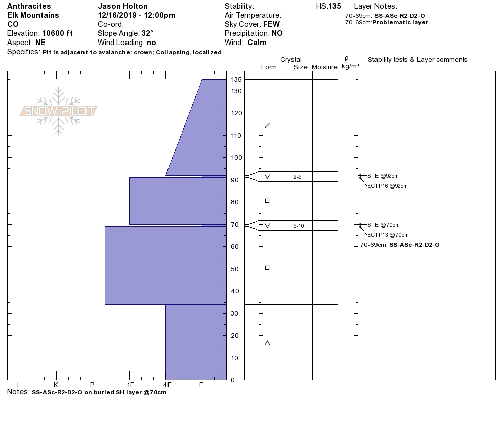
Mountain Weather For 11,000ft. Tuesday 12/17

CB Avalanche CenterWeather

Date: 12/17/2019

Cold and dry. Here we go, that’s the forecast. A high-pressure ridge is working its way over the intermountain west. Clearing sky overnight has allowed low temperatures this morning to drop down to the -20 range in the valleys and the negative single digits in the mountains. A clear sky will at least help fight the cold today, with the warmth of the sun, and high temperatures in the mountains will work into the teens. We’ll see another frigid night on Tuesday, then a better rebound in temperatures on Wednesday. Wednesday looks like a lovely day in the mountains with clear sky and light winds. We’ll have some clouds returning on Thursday as a disturbance passes to our south, then back to high pressure towards the weekend.

  • Today

    High Temperature: 14 to 18
    Winds/Direction: 7 to 17 NW
    Sky Cover: Clear
    Irwin Snow: 0
    Elkton Snow: 0
    Friend’s Hut Snow: 0

  • Tonight

    Low Temperature: -3 to 1
    Winds/Direction: 5 to 15, NW
    Sky Cover: Clear
    Irwin Snow: 0
    Elkton Snow: 0
    Friend’s Hut Snow: 0

  • Tomorrow

    High Temperature: 27 to 31
    Winds/Direction: 5 to 15, SSW
    Sky Cover: Mostly Clear
    Irwin Snow: 0
    Elkton Snow: 0
    Friend’s Hut Snow: 0

Remotely Triggered Avalanche, Wolverine Basin

CB Avalanche Center2019-20 Observations

Location: Crested Butte Area
Date of Observation: 12/16/2019
Name: Evan Ross & Zach Kinler
Subject: Remotely Triggered Avalanche, Wolverine Basin
Aspect: North, North East, North West
Elevation: 8,900-10,200

Avalanches: 2 remotely triggered D1.5 Persistent Slabs failing on 3 to 4mm depth hoar near the ground. One on a NW aspect at 10,200ft and one on a N aspect at 9,700ft. More info in Snowpack Section.

Weather: Mostly Cloudy. Calm Wind. Dropping temps in the afternoon.

Snowpack: HS on this tour was in the 60 to 85cm range. The slab over the mid-pack surface hoar was to thin and soft. The whole snowpack over the depth hoar on the ground was the layer of concern. We found ourselves having to put some extra effort into getting a collapse. Though, when we could get a collapse it was multi-slope scale. Traveling hundreds of feet and changes aspects. This was a classic Persistent Slab Setup. Few if any obvious signs to instability, until boom, a potential game over result. We were not pushing any steep terrain, we mostly saw shooting cracks on slopes near and below 30 degrees. Still these collapses remotely triggered two steeper pockets.

Anthracites Avalanche Ob

CB Avalanche Center2019-20 Observations

Location: Kebler Pass Area
Date of Observation: 12/16/2019
Name:
Subject: Anthracites Avalanche Ob
Aspect: North East
Elevation: 10,600 ft
Avalanches: SS-ASc-R2-D2-O
We were moving on to the top of the slope with the intention of digging a test profile. I jumped up and down several times with no result and decided to jump on one foot to punch deeper into the pack and the failure propagated with quite a bit of energy. 65cm crown, ~120 ft wide. Failed on clearly visible SH layer @70cm. See attached profile dug at crown.

Photos:

Mountain Weather For 11,000ft. Monday 12/16

CB Avalanche CenterWeather

Date: 12/16/2019

The last storm is working its way east of Colorado. We’ll still be dealing with some moisture and clouds on Monday, before drying out Monday Night. We are sitting under northerly flow and the temperatures have already started to drop. Cold single-digit and below zero temps are coming up for the next few days.

A high-pressure ridge will be arriving Monday night. So we’ll get some lovely clear sky, but those low temperatures will really drop overnight on Tuesday and Wednesday morning. We’ll see some clouds around Thursday, then head back into another high-pressure ridge as we look later in the week. So, unfortunately, there isn’t any snow in this week’s forecast.

  • Today

    High Temperature: 5 to 9
    Winds/Direction: 7 to 17, NNW
    Sky Cover: Mostly Cloudy
    Irwin Snow: 0 to 1
    Elkton Snow: 0 to 1
    Friend’s Hut Snow: 0 to 1

  • Tonight

    Low Temperature: -11 to -15
    Winds/Direction: 10 to 20, NNW
    Sky Cover: Mostly Clear
    Irwin Snow: 0
    Elkton Snow: 0
    Friend’s Hut Snow: 0

  • Tomorrow

    High Temperature: 12 to 16
    Winds/Direction: 5 to 15, NW
    Sky Cover: Clear
    Irwin Snow: 0
    Elkton Snow: 0
    Friend’s Hut Snow: 0

Reno Ridge/Cement Obs

CB Avalanche Center2019-20 Observations

Location: Cement Creek Area
Date of Observation: 12/14/2019
Name: Ian Havlick
Subject: Reno Ridge/Cement Obs
Aspect: South West, West, North West
Elevation: 9000-11,200

Avalanches: no avalanches observed due to visibility

Weather: Lull in morning turned to redeveloping snow and wind around 1100. strong wind transport, temperatures in mid 20s

Snowpack: Snow accumulations 20″+ doubling snowpack. soft and unconsolidated, most areas lacking a distinct slab in terrain traveled. Total height of snow ranged from 60-100cm in terrain traveled. wind drifts 4-6ft deep, 1F hardness near treeline and more exposed areas

Gothic Obs

CB Avalanche Center2019-20 Observations

Location: Crested Butte Area
Date of Observation: 12/15/2019
Name: steve banks
Subject: Gothic Obs
Aspect: North, East, South East
Elevation: 9,500

Avalanches: Minimal visibility so not much seen. The following avalanches appeared to run toward the end of the storm on Saturday based on the refill.
East Bowl Gothic R1-D2 Storm Slab
Quigley Creek Baldy r2-D2 Storm Slab
Northern /east facing bowl on Gothic: R3-D2 Persistent Slab
Snodgrass: 5 individual avalanches running on basel facets with crowns up to a meter deep. All of them ran just on the lower edge of the dark timber from 1st bowl through Abbey Lane. R1-D2’s

Weather: Much colder today with overcast skies. It spat snow around 1 pm and seemed like it was gonna giver er a go, but then stopped. Calm winds, no sun.

Snowpack: Settled storm snow about 10-14″ in the Gothic area. Buried surface hoar present and reactive in snowpack tests. Minimal basel facets on East and West facing slopes, musta melted off more in this valley. Still there tho.

Slate River Avalanches

CB Avalanche Center2019-20 Observations

Location: Paradise Divide Area
Date of Observation: 12/15/2019
Name: Evan Ross
Subject: Slate River Avalanches
Aspect: North East
Elevation: BTL/NTL

Avalanches: This short afternoon tour revealed plenty of recent avalanche carnage in the Slate River. These avalanches likely failed some time on 12/14. NE facing aspects were again the bullseye for activity, at both BTL and NTL, or both sheltered and wind-loaded slopes. The crown heights closer to Crested Butte looked a little smaller, while the crowns I got closer to in the Paradise Divide area, were about 1m deep on average. These avalanches were failing at the ground in the well-developed Facets and Depth Hoar. Many crowns were soft-looking as more recent snow and the wind was trying to hide them. It is certainly possible that some avalanches ran on mid-pack persistent week layers, but more investigation is necessary to make that determination. Avalanche size was mostly in the D2 range. Some smaller and some slightly larger.

Lots of interesting pocket avalanches and crown lines along Climax and Schuylkill Ridge that would be interesting to see why those crown lines failed the way they did. SH distributions, or old snow distribution maybe? The largest avalanches I observed were in the Purple Ridge Area. Of particular note, the palace proper looked to have several deep crowns spread through the main avalanche paths.

All in all, visibility sucked. Crown lines were already getting soft looking and debris were difficult see with these conditions. NE was the bullseye.

Weather: Overcast, light snow adding up to an inch or so, calm winds, and dropping temperatures.

Snowpack: The recent snow has really set up. Ski Pen 15 and Boot Pen 60cm. HS was now in the 100cm to 165cm range on the slopes we traveled. No obvious signs to instability.

Snodgrass Obs

CB Avalanche Center2019-20 Observations

Location: Crested Butte Area
Date of Observation: 12/15/2019
Name: Alex Tiberio
Subject: Snodgrass Obs
Aspect: North East

Elevation: 10,000
Avalanches:

Spotted 6 R1D1/2 slides on snodgrass between 1st bowl and abbey lane. All of them on the middle of the 3 pitches. Visibility is not the best. Only got a good pic of one on abbey lane. The others are all similar in size.

Photos:

Backyard avalanche

CB Avalanche Center2019-20 Observations

Location: Crested Butte Area
Date of Observation: 12/14/2019
Name:
Subject: Backyard avalanche
Aspect: North East

Elevation: 9500
Avalanches:

Small avalanche on hillside between Long Lake and Stream View Lane. Storm slab stepped down to persistent weak layer. Bed surface at ground level in multiple locations. 500 yards south of Washington Gulch parking area. Visible from the road.

Weather: Snowing heavily. Winds downslope, down valley

Photos:

Gothic 7am Update

CB Avalanche Center2019-20 Observations

Location: Crested Butte Area
Date of Observation: 12/15/2019
Name: billy barr
Subject: Gothic 7am Update
Aspect:
Weather: Cloudy with steady, strong wind Saturday and stronger gusts, up to about 40 mph. Generally light to no snow, mostly in the afternoon so a dense build-up. Then wind lets up with light to moderate snow ending by midnight. So 24 hour totals are 6½” new snow with 0.54″ of SWE. Currently 31″ on the ground, winters deepest and above average for this date (first time all winter). It is cloudy but calm (hooray). Low temp. 4ºF and currently 6 after a high of 27F. Did I mention no wind? billy