Location: Paradise Divide Area
Date of Observation: 01/23/2020
Name: Zach Kinler
This was a wild week with snow, wind, and a streak of human-triggered avalanches. Read the full summary here.
Location: Paradise Divide Area
Date of Observation: 01/23/2020
Name: Zach Kinler
This was a wild week with snow, wind, and a streak of human-triggered avalanches. Read the full summary here.
Date: 01/23/2020
We are sitting under northwest flow at the nose of a high-pressure ridge. Moisture has been pushing through and adding up some better than anticipated snow totals for the mountains north and west of Crested Butte. For Thursday, upper-level moisture has dried out and this should lead to some breaks in the clouds today. Though we may still see clouds hanging along the Ruby Range and Elk Mountains and continuing to produce periods of light snow at times. Cloud cover looks to decrease Thursday night into Friday. By Friday afternoon we have another blob of moisture moving in. This will again bring increased clouds and could produce some more light snow. A shortwave trough moves in for Sunday into Monday and that will be our next storm in the lineup.
High Temperature: 24 to 28
Winds/Direction: 8 to 18 G30, NW
Sky Cover: Mostly Cloudy
Irwin Snow: 1 to 2
Elkton Snow: 1 to 2
Friend’s Hut Snow: 0 to 1
Low Temperature: 10 to 14
Winds/Direction: 5 to 15, NW
Sky Cover: Partly Cloudy
Irwin Snow: 0
Elkton Snow: 0
Friend’s Hut Snow: 0
High Temperature: 28 to 32
Winds/Direction: 5 to 15, W
Sky Cover: Mostly Cloudy
Irwin Snow: 0 to 1
Elkton Snow: 0 to 1
Friend’s Hut Snow: 0 to 1
Date: 01/22/2020
The low-pressure trough has headed east and we are sitting on the backside in northwest flow. Fog and low-level moisture looks to keep the sky mostly cloudy or obscured today and keep some orographic snowfall going. Upper-level winds increase Wednesday night as the Jet Stream passes overhead. During that time we’ll see some increased wind gusts, but otherwise not much change in the average wind speeds. On Thursday we’ll be on the edge of a building high-pressure ridge to our west, and passing unsettled weather to our north. That ridge looks to struggle in establishing itself through the weekend. With some increased moisture moving through at times. The next storm looks to line up for early next week.
High Temperature: 24 to 28
Winds/Direction: 8 to 18, WNW
Sky Cover: Mostly Cloudy
Irwin Snow: 1 to 3
Elkton Snow: 1 to 3
Friend’s Hut Snow: 1 to 3
Low Temperature: 14 to 18
Winds/Direction: 8 to 18 G 30, WNW
Sky Cover: Mostly Cloudy
Irwin Snow: 0 to 2
Elkton Snow: 0 to 2
Friend’s Hut Snow: 0 to 2
High Temperature: 24 to 28
Winds/Direction: 8 to 18, NW
Sky Cover: Mostly Cloudy
Irwin Snow: 0
Elkton Snow: 0
Friend’s Hut Snow: 0
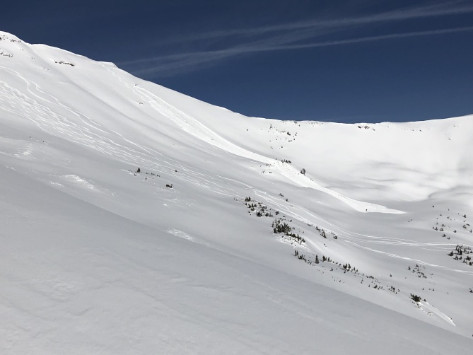
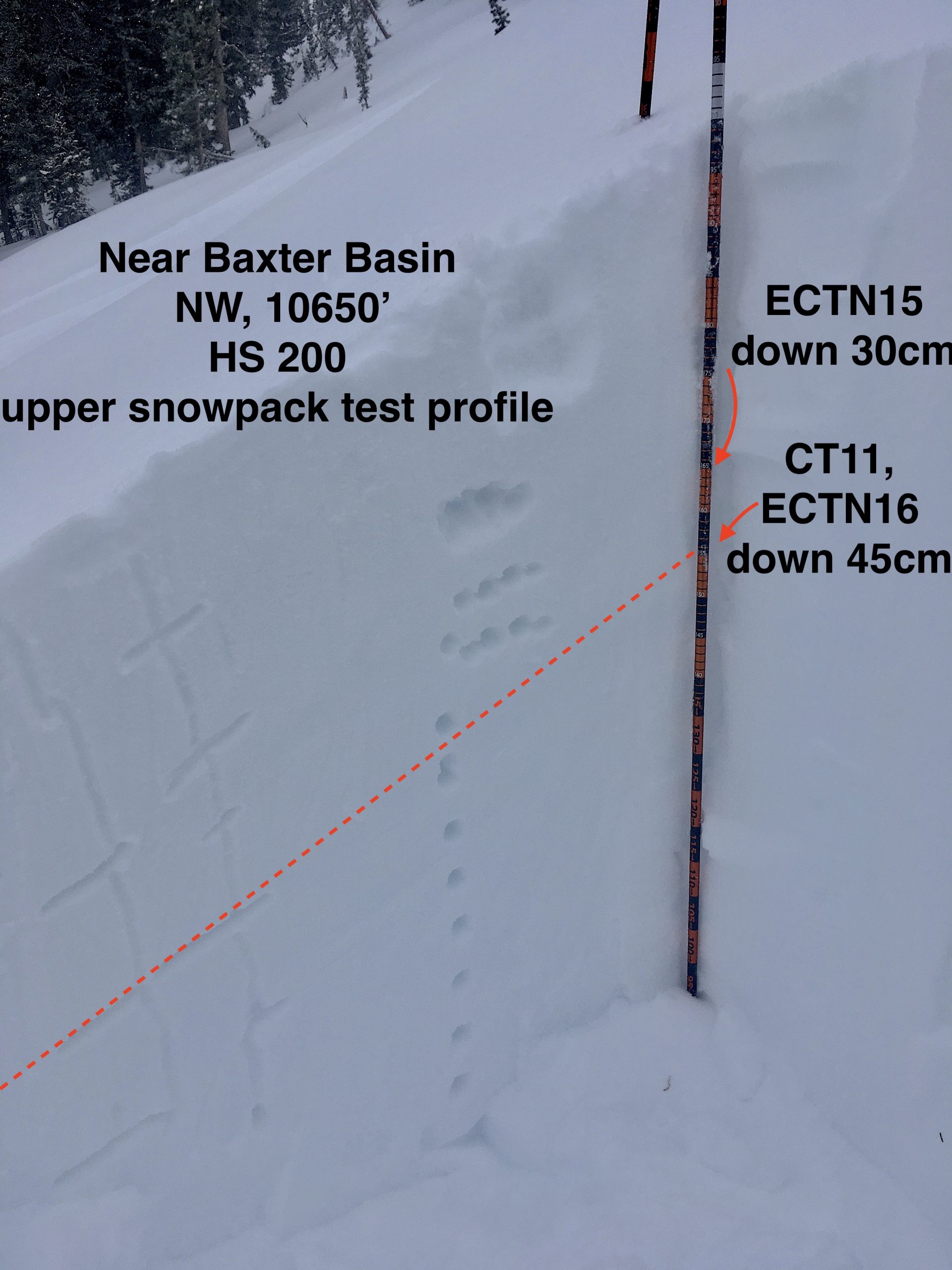
Location: Paradise Divide Area
Date of Observation: 01/21/2020
Name: Eric Murrow
Subject: Poverty Gulch
Aspect: North, North East, East, North West
Elevation: 9000′ – 10650′
Avalanches:none observed
Weather: Overcast skies with light snow and calm winds with just a few very light gusts from the west in the afternoon. New snow accumulations just under 2″ at ~3pm.
Snowpack: While ascending we were able to find surface hoar buried last night on shaded slopes underneath the little bit of new snow. It was generally small only about 4mm. Dug a test profile in the upper snowpack to look at buried weak layers that formed and were buried over the past few weeks. Site was NW facing, at 10650′, that is susceptible to wind events as it is quite open. We choose this site to see if the buried surface hoar was present in windier locations. Down 45cm is a thin layer of near-surface facets with some small surface hoar sitting on it. This layer popped in shovel tilt test, and produced CT11 & ECTN16. Hammering on CT and ECT showed a planar interface down 55cm as well but well beyond standardized test. The slab over the surface hoar has settled significantly over the past week with boot pen about a foot deep.
Photos:
Date: 01/21/2020
Light snow showers have developed around Crested Butte early this morning as a moist, but weak, shortwave trough pushes into Colorado from the southwest. The trough is expected to pass over the Continental Divide around midday as it heads eastward. Snowfall is currently looking modest with snowfall totals between 2 and 5 inches by Tuesday evening. After this first shortwave quickly passes by on Tuesday night, a westerly flow will develop overnight which will keep light, orographic snowfall going for mountains to the west and northwest of Crested Butte. A second shortwave trough will pass by northern Colorado on Wednesday and keep light snowfall lingering through the end of the day. Snowfall totals for Tuesday and Wednesday look to range from 3 to 10 inches range-wide.
A ridge will develop over the area by Friday keeping the area dry for a few days, but by next weekend we may see another round of snowfall.
High Temperature: 28 to 32
Winds/Direction: 5 to 15, SW
Sky Cover: Overcast
Irwin Snow: 3 to 5
Elkton Snow: 3 to 5
Friend’s Hut Snow: 2 to 4
Low Temperature: 14 to 18
Winds/Direction: 4 to 14, W
Sky Cover: Overcast
Irwin Snow: 1 to 3
Elkton Snow: 1 to 3
Friend’s Hut Snow: 1 to 3
High Temperature: 24 to 28
Winds/Direction: 8 to 18, WNW
Sky Cover: Overcast
Irwin Snow: 1 to 3
Elkton Snow: 1 to 3
Friend’s Hut Snow: 1 to 3
Location: Kebler Pass Area
Date of Observation: 01/20/2020
Subject: northern hoar and southern sun
Aspect: North, North East, South East, South, North West
Elevation: 10,000-11,400
Snowpack: noticeably warming snow on southern aspects below 11,400 with roller balling in the afternoon before cloud cover cooled things down.
surface hoar present on north facing snow up as high as 11,300, enough to make for loud facet-y sounding turns in ziggins.
Location: Crested Butte Area
Date of Observation: 01/19/2020
Subject: Rumblings in the Perry Creek area
Aspect: North East, East, South, South West, West
Elevation: 9,000 – 10,200
Avalanches: none observed.
Weather: Sunny and cool. Little wind. Strong solar.
Snowpack: HS variable from 70cm to 120cm along route. Snow generally supportive to skis, except in willows at creek bottoms. Snow surface soft and consistent. Significant wind drifts along W facing drainage features. Ski pen 30 – 50cm, boot pen to the ground with few exceptions. Experienced two, big, rumbling collapses as we skied through low angle sagebrush meadows at 9300′ – 9,600′, S – SW aspect. No cracking. Pole probe at site of collapses indicated 50/50 snowpack – upper half storm snow, lower half cohesionless depth hoar, separated by a stout MF crust. In the low angle terrain we traversed, best travel was along or on top of wind drifts. Had to stay light on your feet on the down to prevent a facet facial.
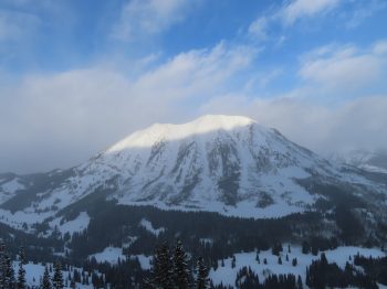
Location: Cement Creek Area
Date of Observation: 01/19/2020
Name: Cosmo
Subject: Cement Mtn Slides
Aspect: North
Elevation: ~11000′
Avalanches:m North facing, rocky slope @ treeline. Looks to have run sometime during last storm cycle. Noticed them on Sunday. Kind of looks like a smaller slab or two broke close to the ridgeline, stepping down into deeper layers further down the slope.
Forecaster note: avalanches reported on 1/15
Weather: 4.5″ of snowfall from last storm @ 9400′ w/ light snowfall continuing late into Saturday afternoon.
Photos:

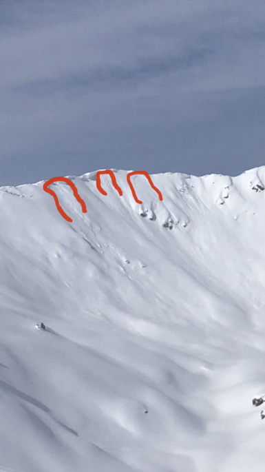
Location: Paradise Divide Area
Date of Observation: 01/19/2020
Name: Joey Carpenter
Subject: p divide obs
Aspect: East, South East, South, South West
Elevation: 9500-11715
Avalanches: Crowns of vary age along angel with the furthest lookers right being the freshest. This must’ve run late during Friday’s wind event. 3xR1D2 E aspect 12k. Also the cross loaded SW feature that gouged to the ground. This slide was filled in significantly making it to appear having run before Friday.
Weather: Wx started cold but warmed quickly to comfortable temps at all elevations traveled. Calm to light winds moved small amounts of snow near ridge tops but nothing significant. Thin light clouds in the afternoon did filter some of the intense solar influence.
Snowpack: Some roller balls and small point releases coming off rock bands during warmest part of the day. Below 10.5 on S & SE there was a razor thin zipper on our return to the sleds around 3pm. Snow surfaces above 10.5k stayed cold where we travelled.
Photos:
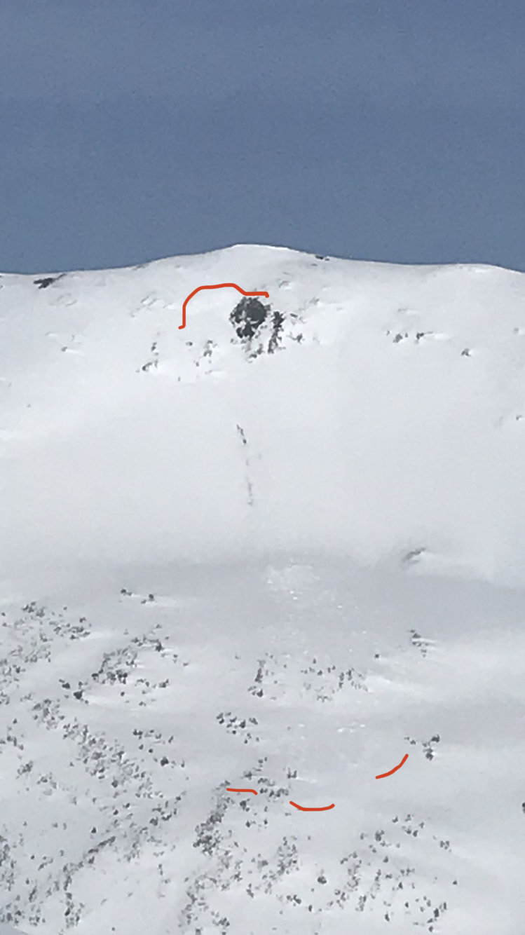
Location: Crested Butte Area
Date of Observation: 01/19/2020
Subject: Mt Emmons (Red Lady Bowl) Skier Triggered Avalanche
Aspect: South East
Elevation: 12,200ft
Avalanches: A skier triggered and was caught in a large avalanche on an alpine southeast-facing slope. They deployed their airbag, took a ride on the surface of the debris, lost a ski, and self-evacuated, uninjured.
(Update) CBAC and CAIC forecast staff visited the area on January 20th.
There was too much hang-fire to visit the crown, but additional information was gathered from lower on the slope. Avalanche debris piles averaged around 1 meter deep and were near or exceeding 3 meters in the deepest pile. The ski tracks did a good job managing the visible previously wind-loaded portions of the slope. In the end, the skier found the right trigger point and released the avalanche from low on the slope.
A profile was dug about 600ft below the highest portion of the crown. The avalanche debris impacted this slope and produced cracks through the snowpit. Tests were performed just above those cracks. Test results and those shooting cracks suggested the avalanche failed below a thin and soft crust capping a weaker layer of facets. That curst generally represents a boundary between weak snow that formed during late 2019, and most of the snow that has fallen in 2020. That interface is estimated to be the same interface producing a string of recent human triggered avalanches. A strong NW wind event in early January likely helped produce a slab over the interface that failed, at this location. While the rest of the snow in January added incremental loading that wasn’t enough for a natural avalanche, but did add stress on the weak layer until the skier found the right trigger point. After initiation, the avalanche further stepped down into the weak snow near the base of the snowpack. Old ski tracks could also be seen on the bed surface.