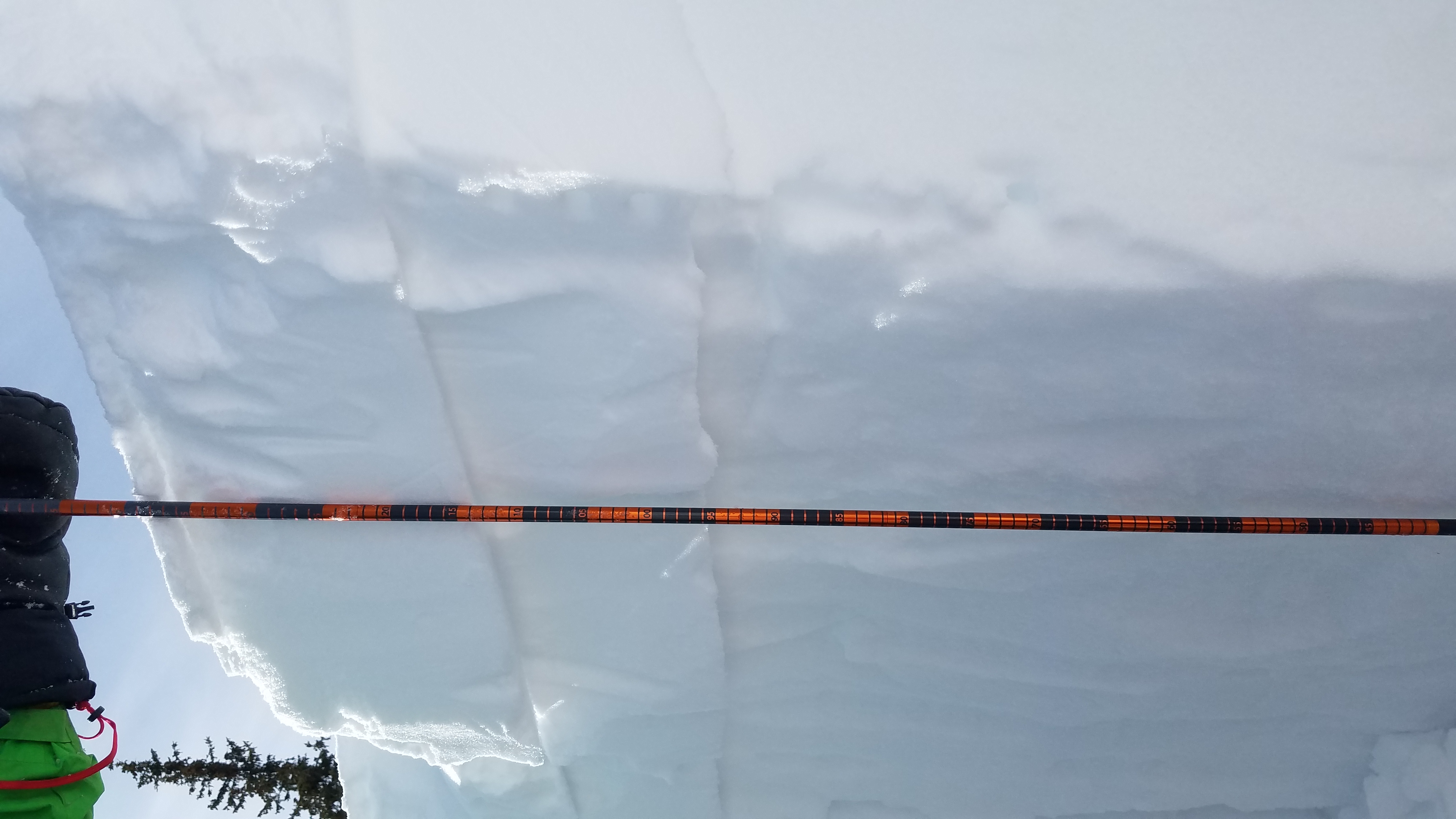
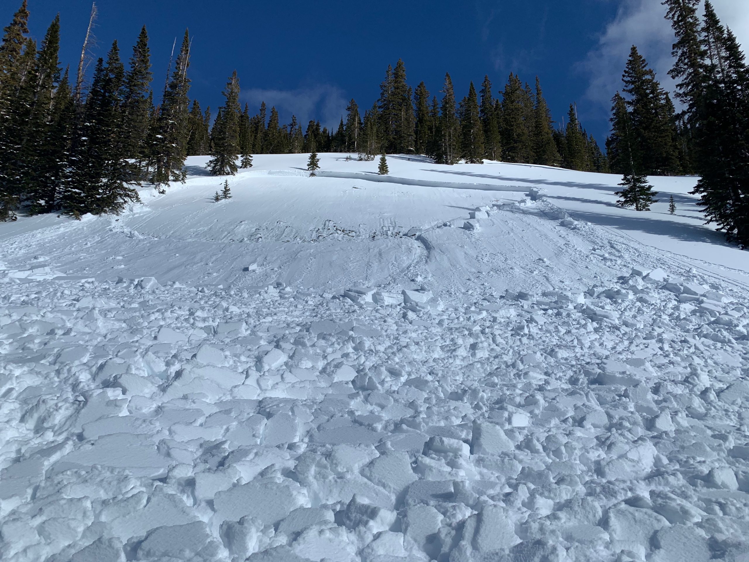
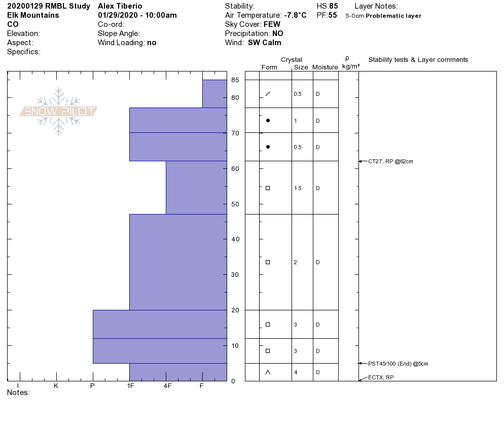
Mountain Weather for 11,000ft. Friday 1/31

CB Avalanche CenterWeather

Date: 01/31/2020

A trace to 3” of snow accumulated yesterday afternoon into the early evening. While NW to NE wind-gusts jumped up as an upper-level jet is passing overhead. Those winds are looking to remain elevated today, with gusts into the 40-50mph range at upper elevations. There is a bit of moisture that will be dropping in on the northerly flow later today and we may see some increasing cloud cover during that time. By Saturday we will have made the transition and landed under the high-pressure ridge. Winds will see a big drop, the sky will be clear and we’ll be on an increasing temperature trend into Sunday with above-average temperatures. The weekend is going to be a nice one!

The next storm comes in the form of a large low-pressure trough making its way across the 4 Corners on Monday. That will land us in SW flow. We’ll have to wait another day to get some more details on that.

  • Today

    High Temperature: 26 to 30
    Winds/Direction: 10 to 20 G35, NW
    Sky Cover: Mostly Clear
    Irwin Snow: 0
    Elkton Snow: 0
    Friend’s Hut Snow: 0

  • Tonight

    Low Temperature: 8 to 12
    Winds/Direction: 5 to 15, NW
    Sky Cover: Partly Cloudy
    Irwin Snow: 0
    Elkton Snow: 0
    Friend’s Hut Snow: 0

  • Tomorrow

    High Temperature: 31 to 35
    Winds/Direction: 5 to 15, W
    Sky Cover: Clear
    Irwin Snow: 0
    Elkton Snow: 0
    Friend’s Hut Snow: 0

popped a small windslab. Also it was windy.

CB Avalanche Center2019-20 Observations

Location: Kebler Pass Area
Date of Observation: 01/31/2020
Name: MR
Subject: popped a small windslab. Also it was windy.
Aspect: North East
Elevation: 11,000

Avalanches: unintentionally popped a small inconsequential windslab on an obvious convexity, 11,000′ NE aspect Baxter Basin, see photo. Light went extremely flat and mistakenly skied over the roll. Not a problem but points to potential for the problem in bigger terrain.

Weather: Big wind. Flagging off peaks, gusts swirling snow above treeline.

Photos:

[/gravityforms]

snow survey at bottom of red lady glades

CB Avalanche Center2019-20 Observations

Location: Crested Butte Area
Date of Observation: 01/30/2020
Name: ADB
Subject: snow survey at bottom of red lady glades
Aspect: South
Elevation: BTL

Weather: Clear in the AM; calm; 6 degrees F

Snowpack: Average snow depth is 30. 6 inches
Water content is 7.4 inches
sun crust
about 1 inch of new snow in last 24 hours.

Mountain Weather for 11,000ft. Thursday 1/30

CB Avalanche CenterWeather

Date: 01/30/2020

Well yesterday was a big swing and a miss. The moisture moved right around us even more than anticipated. We are now sitting under northerly flow with a little moisture and a small disturbance moving through today. Nothing exciting but we do have a small chance to see some flakes. Winds will increase late this afternoon and tonight as the upper-level jet moves overhead and we slide under a building high-pressure ridge. We still have some clouds moving through on Friday, before clear weather and an increasing temperature trend moves in for the weekend. The next storm looks to arrive around Monday.

  • Today

    High Temperature: 24 to 28
    Winds/Direction: 10 to 20, NW
    Sky Cover: Partly Cloudy
    Irwin Snow: 0 to 1
    Elkton Snow: 0 to 1
    Friend’s Hut Snow: 0 to 1

  • Tonight

    Low Temperature: 3 to 7
    Winds/Direction: 10 to 20, N
    Sky Cover: Partly Cloudy
    Irwin Snow: 0 to 1
    Elkton Snow: 0 to 1
    Friend’s Hut Snow: 0 to 1

  • Tomorrow

    High Temperature: 26 to 30
    Winds/Direction: 5 to 15, N
    Sky Cover: Partly Cloudy
    Irwin Snow: 0
    Elkton Snow: 0
    Friend’s Hut Snow: 0

Brush Creek

CB Avalanche Center2019-20 Observations

Location: Brush Creek Area
Date of Observation: 01/29/2020
Name: Evan Ross
Subject: Brush Creek
Aspect: North East, East
Elevation: BTL

Weather: Sky was already clearing by sunset with few clouds through the day. Thicker clouds looked to hang out over by the Ruby Range. Light winds.

Snowpack: General weak snowpack, but not necessarily confidence-inspiring. HS average near 100cm. Ski pen was surprisingly supportable at around 10-15cm, but boot pen was still most of the snowpack. At the lower elevations traveled, the weakest facets near the ground were the layer of concern. I would estimate a little higher in the terrain with more snowpack structure and the mid-pack weak layers could have been more problematic or better defined. On one hand, I wasn’t surprised by the lack of signs of instability while hunting for them, on the other, I didn’t find any confidence in the snowpack and didn’t care to push into steeper terrain.

One test profile on a protected slope at 10,400ft on a NE aspect, 33-degree slope. HS 125. ECT N results in the middle and upper snowpack. Those layers of snow were not drastically different from one another and the whole thing was faceting together. I’d estimate that more concerning structure could have been found higher in the terrain or where the HS was greater. There were about 5cm of F hard facets near the ground and that was the layer of concern in this profile.

Low in the Brush Creek Drainage, there wasn’t much snowpack yet and it was way more punchy. You had to get up towards Teo to start developing the snowpack described. The south side of Teo was looking generally thin and not too concerning. Cross-loaded terrain down low could have had better structure, or up in the alpine.

Taylor Park Near & Above Treeline

CB Avalanche Center2019-20 Observations

Location: Cement Creek Area
Date of Observation: 01/29/2020
Subject: Taylor Park Near & Above Treeline
Aspect: North East, East, South East

Weather: Clear skies; very light, northerly wind; very cold (inversion) at valley floor warming into the 20’s on ascent.

Snowpack: Wind loaded east aspect HS 145cm; bottom 90cm 4F to F facets; 25cm 1F persistent slab on top of that; followed by 25cm soft slab (more recent snow); topped by a 5cm wind crust resting on possible surface hoar. CT29 with a sudden collapse at the ground. ECT did not produce any results in the upper portion of the snowpack or at the ground. We dug our pit in the deepest portion of the slope. Given the CT result, our main concern was collapsing the snowpack at the ground at a shallower point on the slope. Picture shows the slabs in the upper snowpack that seemed well bonded and fairly unreactive. Avoided the steepest portion of the slope and skied creamy, low-angle powder.

Snowmobile Triggered Avalanche

CB Avalanche Center2019-20 Observations

Location: Kebler Pass Area
Date of Observation: 01/29/2020
Subject: Snowmobile Triggered Avalanche
Aspect: South West
Elevation: BTL

Avalanches: Kebler Pass Area. SW Aspect. Rider partially buried. triggered around 2pm. Clouds didn’t develop as forecasted. Partly Cloudy. Clouds a bit thicker right on the Ruby Range. High temps in the area near 30.

Mountain Weather for 11,000ft. Wednesday 1/29

CB Avalanche CenterWeather

Date: 01/29/2020

Maybe the recent Fat Bike World Party is sending the next storm south of us, or maybe the skiers are just not doing their part of the snow dance. Or maybe its the weather forecasters fault for saying the next storm is going south, dammit. Well, I’m not sure who’s fault it is.

A large low-pressure trough is dropping through Utah and heading down and south of Colorado. We still get moisture associated with this storm, just not much snow out of it. A couple of inches west of Crested Butte would be great! While a couple of inches for Crested Butte is wishful. Some light snow showers are about it. Winds will at least remain light today into Thursday. On Thursday afternoon we have another period of increased moisture and should again see some light snow showers.

Dry weather builds for the weekend and an increasing temperature trend.

  • Today

    High Temperature: 24 to 28
    Winds/Direction: 2 to 12 NNW
    Sky Cover: Overcast
    Irwin Snow: 1 to 3
    Elkton Snow: 1 to 3
    Friend’s Hut Snow: 1 to 3

  • Tonight

    Low Temperature: 5 to 9
    Winds/Direction: 2 to 12, NE
    Sky Cover: Partly Cloudy
    Irwin Snow: 0
    Elkton Snow: 0
    Friend’s Hut Snow: 0

  • Tomorrow

    High Temperature: 24 to 28
    Winds/Direction: 5 to 15, NW
    Sky Cover: Mostly Cloudy
    Irwin Snow: 0 to 1
    Elkton Snow: 0 to 1
    Friend’s Hut Snow: 0 to 1