Large Avalanches Scarp Ridge/Irwin Cat Tenure

CB Avalanche Center2019-20 Observations

Location: Kebler Pass Area
Date of Observation: 02/14/2020
Name: Irwin Snow Safety
Subject: Large Avalanches Scarp Ridge/Irwin Cat Tenure
Aspect: South West, West
Elevation: 10-12,000ft

Avalanches:

Tried a lighter touch and made a huge mess anyhow,

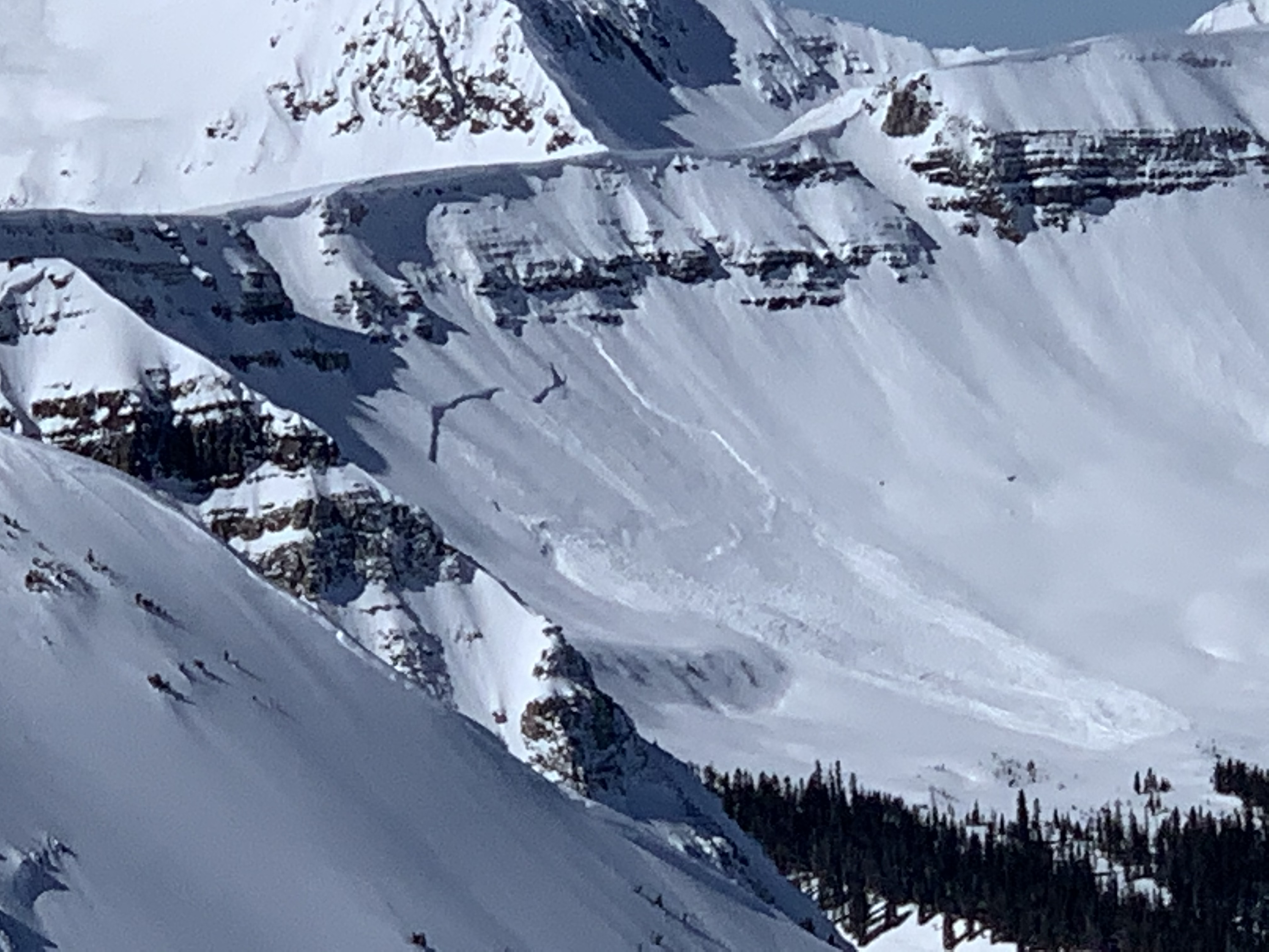
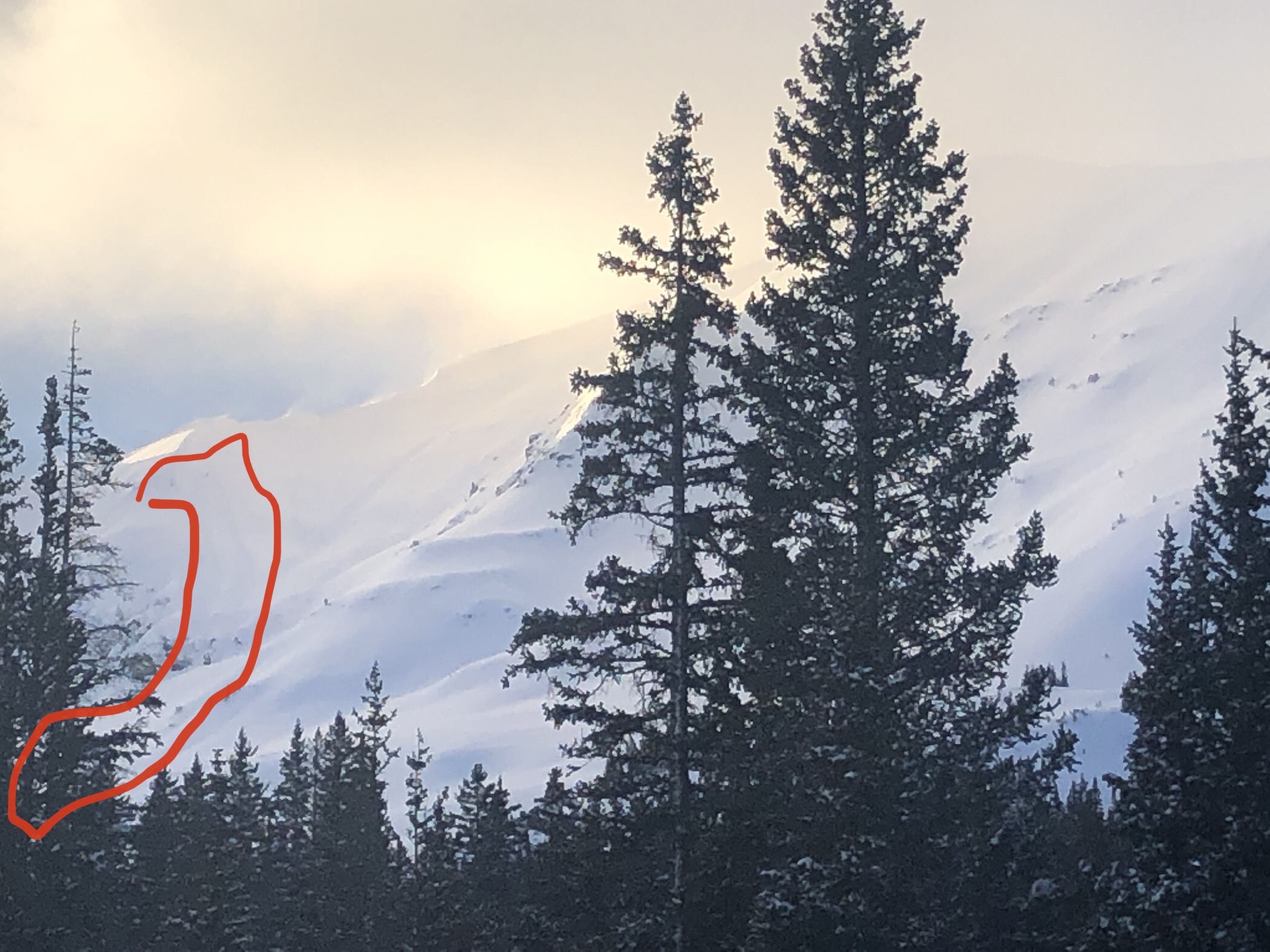
Everything from Spool through the Eyes of the World (SW ATL) is basically gone with 120 to 140 cm crowns running on basal facets on the ground. Complex events with moving slabs triggering additional action. Dramatic. PM form event descriptions are summarized
.

1st event went with a 6lb AB. 2nd event was a single 2×16 and released remotely 10m below the shot. 3rd event triggered by us unloading a 4 shot spread just trying to get the hell out of there. 4th event was a 6lb surface shot cleaning up the remaining hangfire.

All were very large relative to me, but not surpassing D2.5 in size. This area has received intermittent explosive control through the season, but almost no skier compaction. These were the first significant avalanches of the season in all paths that ran.

Spool HS-AB(6lb)-R2/D2.5-G 120cm x 10m x 200m; Right Eyebrow HS-AEr(3lb from 10m)-R2/D2.5-G 140cm x 30m x 200m; Cheddar Bunny Left HS-AE(3lb)-R2/D2-G 140cm x 10m x 200m Left Eyeball Hangfire HS-AE(6lb)-R2/D2-G 140cm x 20m x 150m


Weather: Clear, 20-35 deg, WSW 15-20 g25-46

Snowpack: Good skiing, no signs of instability besides the large explosive triggered avalanches.

Scarps Ridge

CB Avalanche Center2019-20 Observations

Location: Kebler Pass Area
Date of Observation: 02/14/2020
Subject: Scarps Ridge
Aspect: East

Photos:

small avalanche

CB Avalanche Center2019-20 Observations

Location: Paradise Divide Area
Date of Observation: 02/14/2020
Subject: small avalanche
Aspect: North East
Elevation: ATL

Avalanches: One natural R1D1.5 on NE aspect off Purple ridge top from small chunk of cornice falling off. probably 10 feet wide at start but grew wider and then fanned out in flats after running approx. 200 feet.

Weather: Winds transporting snow off ridge.

[/gravityforms]

Mountain Weather for 11,000ft

CB Avalanche CenterWeather

Date: 02/14/2020

Overnight, westerly winds persisted and have averaged in the teens, with gusts into the 20-30mph range. Lower elevations flirt in the single digits above and below zero with temperatures warming into the mid-teens at ridge top this morning. Expect a couple sunny, quiet, classic mid-winter days on tap before we swing back into unsettled weather and persistent snowfall into the middle of next week. Temperatures today should warm close to 30ºF today at 11,000ft, with light westerly winds near and above treeline. More details on the next storm tomorrow. Stay tuned.

  • Today

    High Temperature: 25 to 30
    Winds/Direction: 5-15/WSW
    Sky Cover: Mostly Clear
    Irwin Snow: 0
    Elkton Snow: 0
    Friend’s Hut Snow: 0

  • Tonight

    Low Temperature: 5 to 10
    Winds/Direction: 5-10/W
    Sky Cover: Mostly Clear
    Irwin Snow: 0
    Elkton Snow: 0
    Friend’s Hut Snow: 0

  • Tomorrow

    High Temperature: 27-33
    Winds/Direction: 10-20/W
    Sky Cover: Partly Cloudy
    Irwin Snow: 0
    Elkton Snow: 0
    Friend’s Hut Snow: 0

Kebler Pass/Irwin

CB Avalanche Center2019-20 Observations

Location: Kebler Pass Area
Date of Observation: 02/13/2020
Name: Ian Havlick
Subject: Kebler Pass/Irwin
Aspect: East, South East, South, South West, West
Elevation: 10-12,000ft

Avalanches:

multiple D1 windslabs in UWW terrain. Otherwise, no explosive testing in any terrain
due to low visibility. Observed D2 windslabs in east-facing alpine terrain on Ruby late in day.

Weather: Full storm conditions with S2 snowfall this morning and 20-30mph winds, cold, single-digit temperatures all day. Overcast skies trended to partly cloudy skies after 1500. No significant solar impacts today. 5″ storm total, .45″ SWE

Snowpack: Many minor windslabs ski cut in primarily west facing cross-loaded terrain with largest slabs in west facing, near treeline. Ventured into west-facing alpine, but was largely getting stripped by westerly winds straight up and over the terrain. East and south facing terrain really were not accumulating many reactive windslabs, as we monitored throughout the day. Found very weak crust facet combination on south-facing near treeline behaving very oddly producing widespread collapsing and shooting cracks in terrain we have not trafficked this year. One collapse remotely triggered a very small storm/windslab pocket uphill from us.

Photos:

Cement BTL

CB Avalanche Center2019-20 Observations

Location: Cement Creek Area
Date of Observation: 02/13/2020
Name: Dan K
Subject: Cement BTL
Aspect: East
Elevation: 9200

Snowpack: Quick lap up warm springs and down walrod. While breaking in a fresh skintrack to cut the switchback on warm springs there was poor structure on E facing slopes. 2″ of new snow on top of crust on top of generally supportive slab with some other crust layers likely mixed in. Every 40 steps I would collapse through the slab into a mess of weak snow at the bottom of the pack. Cracking and collapsing remained local and HS was about 80cm on most spots that I checked. The larger E facing slide paths above walrod cutoff trail likely have a similar structure and I would be nervous about them with new loading.

Cement Creek

CB Avalanche Center2019-20 Observations

Location: Cement Creek Area
Date of Observation: 02/13/2020
Name: Cosmo
Subject: Cement Creek
Elevation: 9400′

Snowpack: ~1.5″ new snow @ 6am and snowing lightly.

Toured around yesterday (2/12) between 9300′-10000′ on NW-S aspects. Snow pack varied greatly from aspect to aspect. Some big collapses lower down on open west facing terrain, likely cross loaded. Some smaller, isolated collapses on NW facing convexity just below a ridgline. Signs of instability decreased with elevation. South facing slopes were shallow with a thin sun crust on top of the few inches we got earlier this week, on top of a much thicker/harder crust. Below the lower crust was facets pretty much to the ground. Snow depths ranged from less than 30cm to 140cm depending on where you were.

Mountain Weather for 11,000ft. Thursday 2/13

CB Avalanche CenterWeather

Date: 02/13/2020

At 6am we are still seeing some light snowfall with recent accumulations averaging around 2 inches. Colorado is under northwest flow with moisture streaming in and mostly producing snow in Northern Colorado. The Crested Butte area has been riding the line of either dry weather or clouds and light snow for a few days now. We will again be on the edge of that line today. Light snow looks to continue on the Aspen side of the Elk Mountains and further north in Colorado. Though some moisture looks to continue spilling into our area on Thursday so we can’t rule out the possibility of a little more light snowfall. The latest WRF Model Run shows a slight increase in upper level moister around mid-day, so I’ll hedge my bets with us landing on the more cloudy side of the line as well. Upper-level winds will also be increasing today, so above treeline elevations will see wind gusts in the 40 and 50mph range.

Dry weather works its way in for Friday, while upper-level winds decrease. Looks like we’ll then see more snow arriving by Sunday.

  • Today

    High Temperature: 21 to 25
    Winds/Direction: 10 to 20 G40/ WNW
    Sky Cover: Mostly Cloudy
    Irwin Snow: 0 to 1
    Elkton Snow: 0 to 1
    Friend’s Hut Snow: 0 to 1

  • Tonight

    Low Temperature: 4 to 8
    Winds/Direction: 7 to 17/ W
    Sky Cover: Mostly Clear
    Irwin Snow: 0
    Elkton Snow: 0
    Friend’s Hut Snow: 0

  • Tomorrow

    High Temperature: 24 to 28
    Winds/Direction: 7 to 17/WSW
    Sky Cover: Clear
    Irwin Snow: 0
    Elkton Snow: 0
    Friend’s Hut Snow: 0

Coney’s

CB Avalanche Center2019-20 Observations

Location: Crested Butte Area
Date of Observation: 02/12/2020
Name: Ammon
Subject: Coney’s
Aspect: North, North East
Elevation: 9,000′-10,800′

Avalanches: none observed.

Weather: Weather fluctuated between overcast with moderate winds and broken skies with calm to light winds multiple times.

Snowpack: No instability noted, traveled on N and NE aspects up to 35 degrees.
Dug a quick pit while transitioning in a very sheltered spot, NE aspect at 10,600′, 23 degree slope.
HS 122cm, 7cm F-hard DFs at surface. 30cm 1F slab over 4f FC (2/3). ECTN29 on 2/3 interface, only dug and isolated ECT to below this interface.

Quick Check On South

CB Avalanche Center2019-20 Observations

Location: Kebler Pass Area
Date of Observation: 02/12/2020
Name: Evan Ross
Subject: Quick Check On South
Aspect: South
Elevation: 9,000-10,600

Avalanches:
Got a look at a previously reported avalanche near Evan’s Basin. Debris were fairly fresh so this avalanche likely ran within the last few days. This is a classically wind-loaded terrain feature at 10,700ft. It appeared that the cornice broke and further stepped down and pulled out a slab just under the cornice. The Crown looked to be about 50cm’s thick and probably released near the 2/4 interface and also cleaned to the ground near a rocky cliff thing. SS-N-R1-D1.5. Of note, the slab didn’t propagate widely across the terrain and didn’t appear to produce any shooting cracks on the slope lower down.

Weather: Few clouds in the morning becoming mostly cloudy by mid-day. Low level clouds were moving through with cells producing some light snowfall. New snow accumulation at 3pm was about 1.5 inches. Blowing snow could be seen on ridgelines and upper elevations.

Snowpack: Quick check on low elevation south. No signs to instability traveling on these slopes, even where cross-loaded. Checking out snowpack structure on a 30 degree, cross loaded, south facing slope at 10,600ft. Showed an HS of 135. The 2/4 interface was 6cm thick. There was no collapsing that crust at this time. There was a 45cm 1f slab bonded to that crust, with several thiner crusts near the snow surface that have formed over recent days.