


Location: Paradise Divide Area
Date of Observation: 02/29/2020
Name: Zach Kinler
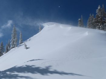
If you missed out on this weeks weather and snowpack roller coaster, check out the full summary here.
Location: Paradise Divide Area
Date of Observation: 02/29/2020
Name: Zach Kinler
If you missed out on this weeks weather and snowpack roller coaster, check out the full summary here.
Location: Kebler Pass Area
Date of Observation: 02/28/2020
Name: Ben Pritchett
Subject: Kebler Pass Obs
Aspect: South East, South, South West
Elevation: BTL
Avalanches: Very minor natural Loose Wet activity. Not a shed cycle.
Weather:
Ridgeline Wind Speed: 5-10 mph
Ridgeline Wind Direction: NW
Wind Loading: None
Temperature: 37 F
Sky Cover: Few
Depth of Total Snow: 200 cm
Weather Description: Cooker afternoon with high thin clouds trapping radiation.
Snowpack: Some shiny-looking areas of saturated snow. Surfaces wetted down to first crust in the upper snowpack on south and southwest facing slopes. It became easy to pull about 2″ of wet snow on the crust, which corresponded to the few shallow Loose Wet avalanches observed. Sunnyside of east and due west became crusted, but could not pull loose wet with hand tests on steep slopes.
Photos:


Date: 02/29/2020
Mostly sunny skies today with moderate westerly winds. Temperatures will once again LEAP into the upper 30s at 11,000ft. This afternoon, expect to see some high clouds begin to stream into the Elks from the west, ahead of tomorrow’s anticipated storm. A low-pressure system will move onshore to the Pacific Northwest today, then split. One piece of the storm will be ejected south, creating a closed low-pressure system that will swirl its way across the Great Basin and impact our mountains tomorrow.
Light snow may start as early as tomorrow morning, but the bulk of the moisture does not look to arrive until about sunset Sunday. Accumulations may fall heavily for short periods of time, but total accumulations do not look all the impressive. Maybe 4-8” in the most favored areas west and north of Crested Butte. Looking ahead, next week appears mostly dry as the jet stream lifts across the northern states and Canadian border.
High Temperature: 35 to 40
Winds/Direction: 10-20/WSW
Sky Cover: Increasing clouds
Irwin Snow: 0
Elkton Snow: 0
Friend’s Hut Snow: 0
Low Temperature: 15 to 20
Winds/Direction: 15-25/WSW
Sky Cover: Mostly Cloudy
Irwin Snow: 0-1″
Elkton Snow: 0-1″
Friend’s Hut Snow: 0-1″
High Temperature: 23 to 28
Winds/Direction: 10-20/NW
Sky Cover: Mostly Cloudy
Irwin Snow: 4-8″
Elkton Snow: 3-6″
Friend’s Hut Snow: 2-5″
Location: Crested Butte Area
Date of Observation: 02/28/2020
Name: MR and SL
Subject: Spoon sluff
Aspect: South
Elevation: 11,400
Avalanches: Skier triggered wet loose avalanche, triggered just above the mostly filled in steep roll in the spoon, broke predictably and ran slowly so was easy to avoid, but wouldn’t have been fun to be in. Ran 150 feet and 30 feet wide, stopping just before some older debris. Was skiing around noon, a little later than we intended.


Date: 02/28/2020
Get out there and work on those goggle tans. Another classic Crested Butte day with warm temperatures, light winds, and clear skies. High pressure and warm, dry weather will continue through the weekend. Sunday is our next chance for mountain snowfall, however, more and more this is looking like somewhat of a non-event in the Elk Mountains. Potential for a small refresh is all we can hope for at this point, but more unsettled weather looks possible early next week. March looks to arrive like a lamb this year.
High Temperature: 35 to 40
Winds/Direction: 5-15/WSW
Sky Cover: Mostly Clear
Irwin Snow: 0
Elkton Snow: 0
Friend’s Hut Snow: 0
Low Temperature: 10-15
Winds/Direction: 5-15/WSW
Sky Cover: Mostly Clear
Irwin Snow: 0
Elkton Snow: 0
Friend’s Hut Snow: 0
High Temperature: 35-40
Winds/Direction: 5-15/WSW
Sky Cover: Mostly Clear
Irwin Snow: 0
Elkton Snow: 0
Friend’s Hut Snow: 0
Location: Crested Butte Area
Date of Observation: 02/27/2020
Name: Zach Kinler
Aspect: North, North East, East, South East
Elevation: 9,000-10,200
Avalanches:
No new avalanches observed.
Weather: Stunning bluebird day, FEW high clouds drifting over. Temps near freezing with light NW breeze occasionally gusting to moderate.
Snowpack: Toured below tree line on the north side of Mt. Emmons on E-N aspects. HS 130- 160 cm. No signs of instability while skiing on slopes up to 35 degrees or stomping small test slopes greater than 35 degrees. Profiled E and N aspects targeting the early February interface. This layer was 43 cm down on E and 60 cm down on N. ECTX on both slopes however on E the 1st loading step after the standard test got propagating results. Both produced PST END results with E 35/100 and N 40/100. Due east surfaces remained dry while any aspect south of east became moist.
Photos:

East aspect 10,000′

PST 35/100 (END) East 10,000′

North aspect, 9600′

PST 40/100 (END) North 9600′
Location: Crested Butte Area
Date of Observation: 02/26/2020
Subject: RMBL Study Plot 2/26/20
Elevation: 9500
Photos:

Location: Crested Butte Area
Date of Observation: 02/26/2020
Subject: Coney’s – propogating results
Aspect: East
Elevation: 9900
Weather: Sunny, cloud cover was BKN-, light wind from the south.
Snowpack: See snowpilot upload.
Photos:

Location: Crested Butte Area
Date of Observation: 02/26/2020
Name: Steve Banks
Subject: Gothic Obs
Aspect: North, East, South, South West
Elevation: 9,600-11,200
Avalanches: Wind slabs, persistent slabs, cornice falls and facet sluffs-we saw it all! Nothing from today, likely Feb 24/25. Large cornice falls triggering not so big slabs on NE facing very steep terrain on Gothic. A PS D2 viewed up on Rustlers Gulch ATL South Facing. Wind slabs on S facing of Belleview ATL. Full depth fast running Facet Sluff NE facing BTL in Copper Creek.
Weather: Sunny AM warmed nicely into the low 20’s. Light winds increased to moderate as clouds increased. Snow flurries by 14:00 with no accumulation Significant blowing snow again. Snow, wind and clouds dissipated as the sun set.
Snowpack: It’s shallow out here! Less snow and more facets than other drainages. Newly formed windboard in most exposed places. Closer to Gothic townsite the snowpack is 40-100 cms average. Depth improves as you move toward Baldy/Belleview. Recent storm totals near 30 cms at higher elevations, redistributed all over. New zipper sun crust formed today from green housing on southerly BTL/NTL slopes.


Date: 02/27/2020
A weak shortwave trough located just east of the divide moved through overnight bringing a slightly warmer air mass, high clouds and very light snowfall to the highest elevations. As this trough quickly departs the region today, expect drier air to filter in with NW flow remaining in place. Light to moderate winds with occasional stronger gusts will be seen as the jet stream remains overhead.
Tonight will be clear, cold and calm as the ridge continues to push east ahead of our next weather maker. On Friday flow will begin to transition towards the SW as a large trough of low pressure makes it way onto the west coast. This system looks to cut off from the main flow and track southward across our area through the weekend which will increase our chances of measurable snowfall.
High Temperature: 25-30
Winds/Direction: 5-15/NW G20
Sky Cover: Mostly Clear
Irwin Snow: 0-trace
Elkton Snow: 0-trace
Friend’s Hut Snow: 0-trace
Low Temperature: 5 to 10
Winds/Direction: 5-15/WNW
Sky Cover: Mostly Clear
Irwin Snow: 0
Elkton Snow: 0
Friend’s Hut Snow: 0
High Temperature: 30 to 35
Winds/Direction: 5-10/ W
Sky Cover: Clear
Irwin Snow: 0
Elkton Snow: 0
Friend’s Hut Snow: 0