It snowed more

CB Avalanche Center2019-20 Observations

Location: Kebler Pass Area
Date of Observation: 03/30/2020
Name: Steve Banks
Subject: It snowed more
Aspect: North East
Elevation: 9,000-12,000

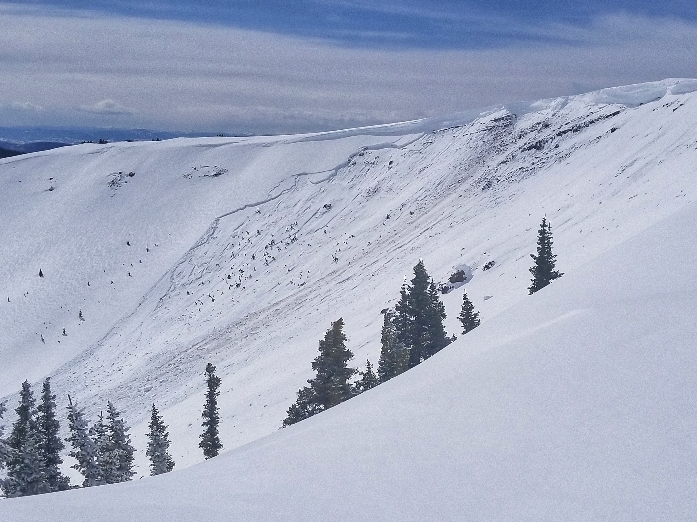
Avalanches: None observed today

Weather: It snowed a lot more than expected. Sunny spells in the morning gave way to S3 from noon to 2 pm. Even then it kept snowing mostly S1-2 through the afternoon. Hell yea. It was cold at treeline with winds building in the afternoon from the West. Moderate blowing snow was observed from 3 pm on. When the sun popped down low it got hot quick.

Snowpack: We didn’t dig around much, but seemed to be 40-50 cms of recent snowfall since last week. Last night/today’s snow remained cold and light. Saturday snow wasn’t crusty, but dense. Much less new snow at lower elevations. No signs of instability were found on slopes up to 35 degrees.

Storm obs

CB Avalanche Center2019-20 Observations

Location: Kebler Pass Area
Date of Observation: 03/30/2020
Name: Eric Murrow
Subject: Storm obs
Aspect: North, North East, East, South East, South
Elevation: 9,000′ – 11,600′

Avalanches: Skier triggered two very small Wind Slabs on very open south-facing slopes behind ribs. R1D1
Observed a D1.5 Wind Slab in East Bowl in Anthracites – crown already filled in completely by 4pm.
Observed two fresh avalanches on drifted southeast-facing near treeline features in Elk Basin and Evans Basin on Emmons massif. Only got a brief view a long way off but looked D1.5ish.
Weather: Mostly cloudy skies with a low ceiling obscuring alpine terrain much of the day. Winds increased in speed out of the northwest through the afternoon. Observed snow transport onto east through south-facing slopes at near treeline elevation band. Snowfall was often light with a short period in the early afternoon that was around S1/S2. Accumulations from 930 to 4pm around 2 inches.

Snowpack: Storm totals reached ~9inches at 11,000 feet at 330pm. Snow was fairly dense. East through south-facing terrain up to 11500′ had soft crust underneath the most recent snow. Found soft drifts up to 14 inches on leeward southeast slopes. A brief period of sun midday put a soft crust on east and south slopes. Experienced some minor cracking on drifted features, but no signs of instability on northerly terrain. Sloughing was minimal on north slopes. Wind texture and stiffening were present on most open slopes.

Photos:

Schuykill Ridge Birthday Bowl Nose

CB Avalanche Center2019-20 Observations

Location: Paradise Divide Area
Date of Observation: 03/30/2020
Name: Abby
Subject: Schuykill Ridge Birthday Bowl Nose
Aspect: North East, East
Elevation: 11000

Avalanches: Wet slab on skiers left birthday bowl. New snow (2-4inches) slid easily over crust on sun effected aspects.

Weather: Light snowfall, partly sunny, no wind.

Cement Creek Morning Weather Update

CB Avalanche Center2019-20 Observations

Location: Cement Creek Area
Date of Observation: 03/30/2020
Name: Cosmo
Subject: Cement Creek Snow
Elevation: 9300′

Weather: Light snowfall this morning. 1″ on the ground @ 6:30am.

Gothic 7am Weather Update

CB Avalanche Center2019-20 Observations

Location: Paradise Divide Area
Date of Observation: 03/30/2020
Subject: Gothic 7am Weather Update

Weather: Some snow after dark for a couple hours and then a bit more starting around 4 a.m. so new snow totals are 3″ with a light 0.17″ of water. snow pack is at 48½”. After a cold start to yesterday (2ºF) it is milder this morning with a low of 19F and currently 22F. No wind which is nice. Currently obscured with light snow.

Mountain Weather for 11,000ft. Monday 3/30

CB Avalanche CenterWeather

Date: 03/30/2020

The low-pressure trough is moving through Colorado this morning. Upper elevation winds are light for once and overnight snow accumulations only look like a dusting. Between early this morning and noon today is when the magic has got to happen. This will be our best chance for accumulating snow. Another 2 to 4” is in the forecast, big money lets beat that. This afternoon we’ll be moving into a drying trend for the coming week.

For Monday Night and looking out through most of the next week. We’ll be just south of any storms or snow for this time period. We’ll see an increase in winds and an increase in temperatures. We don’t have snow in the coming week’s forecast, but we do have the sun.

  • Today

    High Temperature: 31 to 35
    Winds/Direction: 5 to 15/WNW
    Sky Cover: Mostly Cloudy
    Irwin Snow: 2 to 4
    Elkton Snow: 2 to 4
    Friend’s Hut Snow: 1 to 3

  • Tonight

    Low Temperature: 18 to 22
    Winds/Direction: 5 to 15/W
    Sky Cover: Partly Cloudy
    Irwin Snow: 0
    Elkton Snow: 0
    Friend’s Hut Snow: 0

  • Tomorrow

    High Temperature: 35 to 39
    Winds/Direction: 8 to 18/WSW
    Sky Cover: Mostly Clear
    Irwin Snow: 0
    Elkton Snow: 0
    Friend’s Hut Snow: 0

Cornice – Red Lady skin track

CB Avalanche Center2019-20 Observations

Location: Crested Butte Area
Date of Observation: 03/29/2020
Name: Dave Bum
Subject: Cornice – Red Lady skin track
Aspect: North East
Elevation: 11,600

Avalanches: Cornice Fall near the cliff band section of the Red Lady skin track.
Surprisingly close to the track that everyone uses. 10+ people where ahead of us. It failed right after we past it.

Weather: Time 11:45 which was right before the weather rolled in and probably the warmest part of the day with the most solar.
Wind: Calm

[/gravityforms]

East face Cement Mountain

CB Avalanche Center2019-20 Observations

Location: Cement Creek Area
Date of Observation: 03/29/2020
Subject: East face Cement Mountain
Aspect: East
Elevation: 12,200

Avalanches: Cornice fall triggered R2D2 slide within the last few days. Looks to have run about 1,000 vertical feet.

Upper Cement/Brush Creek

CB Avalanche Center2019-20 Observations

Location: Cement Creek Area
Date of Observation: 03/29/2020
Name: Zach Kinler
Aspect: North, North East, East, South East, South
Elevation: 9,000′-12,400′
Avalanches:

Hunter Hill 12,500′ ENE- 2x D2.5 Persistent Slab
Lambertson Pk 11,800′ W- D1.5 Persistent Slab
These avalanches were estimated to have run sometime during the 3/24-3/26 wind event, likely being triggered by cornice falls.

Weather: Increasing clouds with light snow showers developing over higher terrain by afternoon, light to moderate S/SW wind on ridgeline. Temps above ~11K remained below freezing.

Snowpack: 1-2″ HST from Friday/Saturday’s shortwave. Southerly breezes would occasionally move small amounts of recent snow onto leeward aspects above tree line however minimal recent wind slab development observed in this area. Stacks of crusts present in the upper snowpack on sunny slopes. Recent large avalanches and cornice falls were observed on drifted easterly alpine features similar to what has been seen around other parts of the area following the wind event.

Mountain Weather for 11,000ft. Sunday 3/29

CB Avalanche CenterWeather

Date: 03/29/2020

The stars are out this morning and we should have a nice sunrise, but clouds are on their way for Sunday. An approaching shortwave will put us in southwest flow today and moisture ahead of that storm will be pushing high clouds into the area. If not sooner, we’ll be under cloud cover by mid-day. We may see some very light snowfall in the Ruby Range this afternoon, but snow showers don’t look to get going until sunset or this evening. For the mountains west and north of Crested Butte, 2 to 4” tonight and 2 to 4” for tomorrow still looks like the range of snow.

Heading into Tuesday and the week ahead, it looks like we’ll be sitting under dry westerly flow. Any snow is looking to stay to our north at the moment.

  • Today

    High Temperature: 30 to 34
    Winds/Direction: 5 to 15/WSW
    Sky Cover: Increasing clouds
    Irwin Snow: 0 to 1
    Elkton Snow: 0 to 1
    Friend’s Hut Snow: 0 to 1

  • Tonight

    Low Temperature: 12 to 16
    Winds/Direction: 2 to 12/SW
    Sky Cover: Overcast
    Irwin Snow: 2 to 4
    Elkton Snow: 2 to 4
    Friend’s Hut Snow: 1 to 3

  • Tomorrow

    High Temperature: 30 to 34
    Winds/Direction: 5 to 15/WNW
    Sky Cover: Overcast
    Irwin Snow: 2 to 4
    Elkton Snow: 2 to 4
    Friend’s Hut Snow: 1 to 3