


NAME: ScottDATE: 3/15/15LOCATION: EmmonsELEVATION: 9,000-12,000ASPECT: SEWEATHER: Clear and warm with light windsSNOWPACK: Strong crust in the morning on south aspects. Light winds helped keep the surface cool, although direct sun hastened the melting process. By 11:30 there was 4cm of corn snow above a supportive crust on S-SE aspects. No signs of rollerballs, pinwheels, or wet loose slides prior to 1230.
Mt. Emmons
NAME: Evan Ross
DATE: 3/11/15
LOCATION: Mt. Emmons
ELEVATION: 12,000-9,000
ASPECT: N
WEATHER: Thin overcast Clouds created a very warm greenhouse effect below ridgeline where there was no wind. At ridgeling winds where SW light with moderate gusts during the first half of the day.
SNOWPACK:
On north facing upper elevations (ATL/NTL) boot pen averaged about 20cm. HS was around 150cm-195cm on average. Feeling with a probe through the terrain, the PS structure was about 80cm thick with a relatively thin layer of weaker snow below. At these elevations the snow surface stayed dry despite the warm conditions. At lower elevations (BTL) snow surfaces where moist. No obvious or resent sings to instability noticed at all elevations.
ATL snow surfaces on South where still frozen at noon.
Snodgrass Observation
NAME: Evan Ross
DATE: 3/9/15
LOCATION: Snodgrass
ELEVATION: BTL
ASPECT: NE
WEATHER: Mostly clear, real warm again and no wind.
SNOWPACK:
Persistent slab structure is really scary in many places, yet we didn’t feel a single collapse traveling on a variety of slope angles and terrain features. Where the HS is deep, over 150cm say, the facets below the slab have more resistance and better bonding with one another. Where the HS is shallower the facets below the slab are fist hard and full sugar. Boot pen around 20-30cm on all slopes.
AVALANCHE OBS:
All kinds of old carnage on this side of snodgrass. Most of the terrain over 35 degrees has already avalanched, but there are still a few pockets left.
Washington Gultch
NAME: KristaDATE: 2015.03.08ACTIVITY: Avy 1 ClassLOCATION: Coney’sASPECT: NE
WEATHER: Mostly clear, mostly warm, only a little breezeAVALANCHE/SNOWPACK OBS: Avy 1 class toured up a less than 30 degree north facing slope from 9500 – 11,000ft. 140cm (+/-) snow depth, with a distinct strong over weak snow pack was felt throughout the tour. No signs of instabilities were felt under foot today, however the class was amazed with the amount of avalanches that were visible (literally everywhere) from their ridge top tour. Skiing quality was supportive, penetrating only 20 cm into the snowpack, and no crusts were felt on the north aspects. A new sun crust was forming on the lower angle terrain however, where the sun was affecting the surface of the snow.
Washington Gulch
NAME: JSJ, KRISTA
DATE: 2015.03.07
LOCATION: Wash Gulch
ELEV: 9,100-10,500′
ASPECT: N-NE
WEATHER: Clear, sunny, warm, no wind
AVALANCHE / SNOWPACK OBS: Found ~55cms storm snow (F-4F hard) overlying a distinct surface hoar/buried surface layer on top of 100+cms of mostly 4F hard facets. Two large collapses observed on slope of 34* N slope in dark timber with weight of entire group on slope to produce it. Also saw lots of evidence of recent cracking displacing the storm slab on small steep terrain features, but nothing moved despite the slope angle, guessing compressive support on these small slopes was enough to hold it up in shear strength. A test snow profile revealed CTE & CTM on a layer about 25cms above the ground (or 125cms down !). Sudden Planar failure character on both. Also Tilt Test produced very easy failure results with Sudden Planar fracture character results on a layer 10cms below the surface w/i the storm snow, but no evidence of any activity on this layer anywhere in observed recent activity out in the hills.
Mt Emmons
Name: Evan Ross
DATE: 3/6/15
LOCATION: Mt Emmons
ELEVATION: ATL-BTL
ASPECT: SE/S
WEATHER: Really blue, really hot and really no wind.
SNOWPACK:
The march toaster oven was in full effect. Snow surfaces at all elevations became moist by mid day. Differently some rapped settlement going on. Didn’t observe any obvious signs to instability while traveling through terrain but the wide spread avalanche cycle speaks to the potential.
AVALANCHE OBS:
The lookers left side of RLB (Northeast facing) ran at some point. D2.5 with a 3-4 food deep crown and about 3,000ft wide when measured on Google Earth! Otherwise large avalanches can be observed everywhere on all aspects at all elevations.
Photos from recent avalanche cycle
Photos by Zach Guy
Snow cat triggered slides above the Nordic Center
Fresh windslabs that ran yesterday or last night on the SE face of Mt. Owen

Northwest Bowl in the Anthracites, ran wall to wall

Southeast face of Mt. Afley

East to Northeast face of Mt. Owen. I think the looker’s right half ran yesterday or last night, the looker’s left ran earlier in the storm. 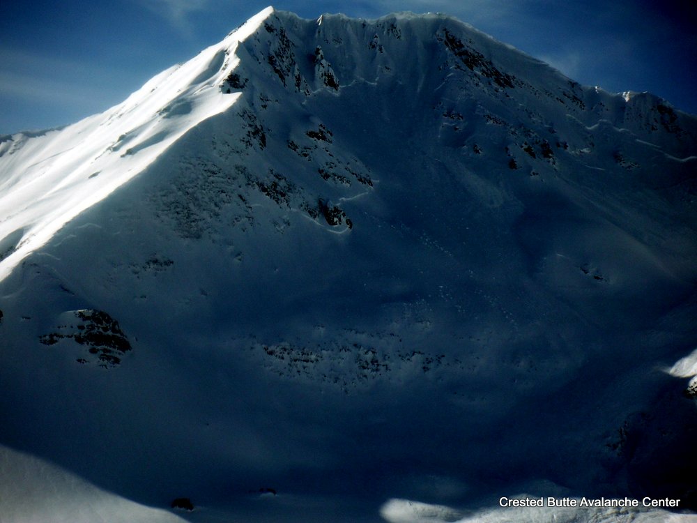
Gothic Update
Only light to moderate wind Tuesday by mid day with light snow picking up at sunset last night. The 24 hour totals are 8″ new snow with 0.55″ water as snowpack reached 59½”, now at 59″. Cloudy currently with thankfully no wind and cooler at 10ºF. Flat light and little visibility so nothing new on slides to report but run-out zones show nothing new that i can tell. billy
Nordic Center avalanche
We have another good slope failure above the Nordic Center. I pulled it out with a cat as I was plowing the ditch road.
Crested Butte Area
GUIDE: JB
DATE: 201500304
LOCATION: CB Zone
ELEV: 9,400-10,600
ASPECT: S-SW
WEATHER: SCT to BKN, winds moderate gusting to strong BTL & NTL fom NW
Strong winds kicked up ~1:30 & blew in AM skin track in the open fields. little drifting in forest.
AVALANCHE / SNOWPACK OBS:
Good views of in-numerable slides on E -NE, around long lake, climax chutes, etc
2 collapses in open meadow (S slope @ 27* & 9,500ft) where the melt freeze crust from mid storm warm up ~20cm down is 1F (4cm thick) over Fist layer. HS 45cm
1 collapse SW slope @15* & 10,600ft) Similar structure but crust is thinner ) & only 4F. HS 70cm
Tests @ 10,400 SW 10* slope angle 30* HS 55cm Structure: 50cm storm snow sitting on 5cm mfrc (moist poly crystals)
CTM (11) SC 25cm down on 4F mfcr
ECTN (11) ” “
ECTN (11) ” “
Ski pen 15-25cm