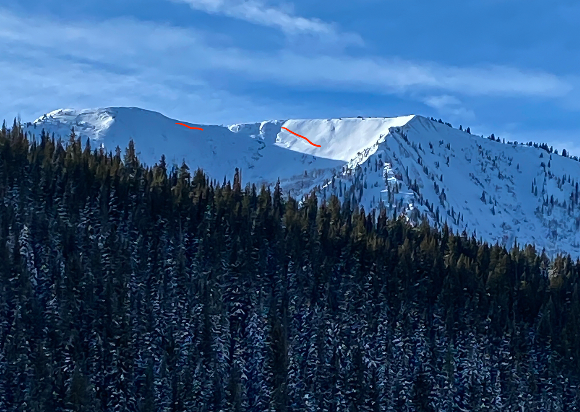
Mountain Weather for 11,000ft

CB Avalanche CenterWeather

Date: 12/19/2019

Though moderated a bit by overnight cloud cover, cold overnight temperatures persist, with strong valley inversions settling into the Gunnison and East River valleys. This morning Crested Butte hovers around -10ºF while just uphill on Mount Crested Butte, its a balmy 20 above zero! Thats a 30 degree spread 1200 vertical feet. Look for another dry, classic sunny Colorado day. Light southwesterly winds bringing in warmer temperatures and todays highs at 11,000ft in the mid 20s. Looking ahead, the next snow producer continues to take shape in the central Pacific and potentially impacts our area for Christmas.

  • Today

    High Temperature: 22-27
    Winds/Direction: 5-10/WSW
    Sky Cover: Partly Cloudy
    Irwin Snow: 0
    Elkton Snow: 0
    Friend’s Hut Snow: 0

  • Tonight

    Low Temperature: -5 to 0
    Winds/Direction: 5-10/SW
    Sky Cover: Partly Cloudy
    Irwin Snow: 0
    Elkton Snow: 0
    Friend’s Hut Snow: 0

  • Tomorrow

    High Temperature: 25-30
    Winds/Direction: 5-10/SW
    Sky Cover: Partly Cloudy
    Irwin Snow: 0
    Elkton Snow: 0
    Friend’s Hut Snow: 0

I think I froze My face

CB Avalanche Center2019-20 Observations

Location: Paradise Divide Area
Date of Observation: 12/18/2019
Name: Kirk

Subject: I think I froze My face

Aspect: South East

Elevation: 11715

Weather: I would bet Santa Claus it was colder in CB than the North Pole this morning at the trailhead. It warmed up to a balmy 17.5 degrees by noon. Winds from West 5mph starting to cloud up by 11am

Snowpack: No signs of instability on skin track. A supportive snowpack with 8″ of condensed snow with a touch of a wind on top.

Coolin’ at the playground Ya Know!

CB Avalanche Center2019-20 Observations

Location: Kebler Pass Area
Date of Observation: 12/18/2019
Name: MR

Avalanches:

Crowns galore throughout the playground area off East Ohio peak behind the Anthracites, north facing, estimate around 11,200-11,400, assume to be from the 12/14 or 12/16 avalanche cycle. Also included is a photo of the crown of the big chute slide already reported, and slides on Axtell 4th bowl

Photos:

Few More Avalanche Photos and Updates

CB Avalanche Center2019-20 Observations

Date of Observation: 12/17/2019
Name: Evan Ross
Subject: Few More Avalanche Photos and Updates

Avalanches: A natural avalanche was reported on Whetstone Mountains. It released in a deeply drifted east aspect and ran during the morning of 12/17.
A couple large natural avalanche were confirmed to have run in the Anthracites around Monday 12/16. These are estimated to have released on SH in the middle of the snowpack.
A few other pictures are attached from avalanches that released around the 12/14 cycle.

Weather: Clear sky and warmer temps up out of the inversions. Winds at upper elevations were still drifting some snow at times, otherwise calm at lower elevations.

Snowpack: Traveling around the Kebler Pass area yesterday. The snow surfaces in the alpine have really been worked over by winds in the last few days. lots of drifting and wind textured snow surfaces. Traveled on a number of below treeline slopes facing east to south with no signs to instability, and a few protected northerly slopes with the same result. HS averaged in the 70 to 90cm range.

Mountain Weather For 11,000ft. Wednesday 12/18

CB Avalanche CenterWeather

Date: 12/18/2019

Strong inversions set up again under a clear overnight sky. Valley temps dropped near -20, while 11,000ft temperatures have been on a steady increase overnight and currently in the positive teens this morning. We are transitioning into southwest flow under a high-pressure ridge. Warmer air is already starting to push in, and this will help those mountain temperatures warm to near 30 degrees today. Valley temperatures may struggle to climb in the same fashion if the inversions stay put.

Clouds will start increasing later today and keep increased clouds in the forecast throughout Thursday as small low-pressure moves through. Unfortunately, there isn’t any precipitation associated with this system. A high-pressure ridge is back for Friday and dry weather continues into the weekend.

  • Today

    High Temperature: 27 to 31
    Winds/Direction: 5 to 15, SSW
    Sky Cover: Increasing clouds
    Irwin Snow: 0
    Elkton Snow: 0
    Friend’s Hut Snow: 0

  • Tonight

    Low Temperature: 14 to 18
    Winds/Direction: 5 to 15 SSW
    Sky Cover: Mostly Cloudy
    Irwin Snow: 0
    Elkton Snow: 0
    Friend’s Hut Snow: 0

  • Tomorrow

    High Temperature: 22 to 26
    Winds/Direction: 5 to 15, WNW
    Sky Cover: Partly Cloudy
    Irwin Snow: 0
    Elkton Snow: 0
    Friend’s Hut Snow: 0

Mountain Weather For 11,000ft. Tuesday 12/17

CB Avalanche CenterWeather

Date: 12/17/2019

Cold and dry. Here we go, that’s the forecast. A high-pressure ridge is working its way over the intermountain west. Clearing sky overnight has allowed low temperatures this morning to drop down to the -20 range in the valleys and the negative single digits in the mountains. A clear sky will at least help fight the cold today, with the warmth of the sun, and high temperatures in the mountains will work into the teens. We’ll see another frigid night on Tuesday, then a better rebound in temperatures on Wednesday. Wednesday looks like a lovely day in the mountains with clear sky and light winds. We’ll have some clouds returning on Thursday as a disturbance passes to our south, then back to high pressure towards the weekend.

  • Today

    High Temperature: 14 to 18
    Winds/Direction: 7 to 17 NW
    Sky Cover: Clear
    Irwin Snow: 0
    Elkton Snow: 0
    Friend’s Hut Snow: 0

  • Tonight

    Low Temperature: -3 to 1
    Winds/Direction: 5 to 15, NW
    Sky Cover: Clear
    Irwin Snow: 0
    Elkton Snow: 0
    Friend’s Hut Snow: 0

  • Tomorrow

    High Temperature: 27 to 31
    Winds/Direction: 5 to 15, SSW
    Sky Cover: Mostly Clear
    Irwin Snow: 0
    Elkton Snow: 0
    Friend’s Hut Snow: 0

Remotely Triggered Avalanche, Wolverine Basin

CB Avalanche Center2019-20 Observations

Location: Crested Butte Area
Date of Observation: 12/16/2019
Name: Evan Ross & Zach Kinler
Subject: Remotely Triggered Avalanche, Wolverine Basin
Aspect: North, North East, North West
Elevation: 8,900-10,200

Avalanches: 2 remotely triggered D1.5 Persistent Slabs failing on 3 to 4mm depth hoar near the ground. One on a NW aspect at 10,200ft and one on a N aspect at 9,700ft. More info in Snowpack Section.

Weather: Mostly Cloudy. Calm Wind. Dropping temps in the afternoon.

Snowpack: HS on this tour was in the 60 to 85cm range. The slab over the mid-pack surface hoar was to thin and soft. The whole snowpack over the depth hoar on the ground was the layer of concern. We found ourselves having to put some extra effort into getting a collapse. Though, when we could get a collapse it was multi-slope scale. Traveling hundreds of feet and changes aspects. This was a classic Persistent Slab Setup. Few if any obvious signs to instability, until boom, a potential game over result. We were not pushing any steep terrain, we mostly saw shooting cracks on slopes near and below 30 degrees. Still these collapses remotely triggered two steeper pockets.

Anthracites Avalanche Ob

CB Avalanche Center2019-20 Observations

Location: Kebler Pass Area
Date of Observation: 12/16/2019
Name:
Subject: Anthracites Avalanche Ob
Aspect: North East
Elevation: 10,600 ft
Avalanches: SS-ASc-R2-D2-O
We were moving on to the top of the slope with the intention of digging a test profile. I jumped up and down several times with no result and decided to jump on one foot to punch deeper into the pack and the failure propagated with quite a bit of energy. 65cm crown, ~120 ft wide. Failed on clearly visible SH layer @70cm. See attached profile dug at crown.

Photos:

Mountain Weather For 11,000ft. Monday 12/16

CB Avalanche CenterWeather

Date: 12/16/2019

The last storm is working its way east of Colorado. We’ll still be dealing with some moisture and clouds on Monday, before drying out Monday Night. We are sitting under northerly flow and the temperatures have already started to drop. Cold single-digit and below zero temps are coming up for the next few days.

A high-pressure ridge will be arriving Monday night. So we’ll get some lovely clear sky, but those low temperatures will really drop overnight on Tuesday and Wednesday morning. We’ll see some clouds around Thursday, then head back into another high-pressure ridge as we look later in the week. So, unfortunately, there isn’t any snow in this week’s forecast.

  • Today

    High Temperature: 5 to 9
    Winds/Direction: 7 to 17, NNW
    Sky Cover: Mostly Cloudy
    Irwin Snow: 0 to 1
    Elkton Snow: 0 to 1
    Friend’s Hut Snow: 0 to 1

  • Tonight

    Low Temperature: -11 to -15
    Winds/Direction: 10 to 20, NNW
    Sky Cover: Mostly Clear
    Irwin Snow: 0
    Elkton Snow: 0
    Friend’s Hut Snow: 0

  • Tomorrow

    High Temperature: 12 to 16
    Winds/Direction: 5 to 15, NW
    Sky Cover: Clear
    Irwin Snow: 0
    Elkton Snow: 0
    Friend’s Hut Snow: 0

Reno Ridge/Cement Obs

CB Avalanche Center2019-20 Observations

Location: Cement Creek Area
Date of Observation: 12/14/2019
Name: Ian Havlick
Subject: Reno Ridge/Cement Obs
Aspect: South West, West, North West
Elevation: 9000-11,200

Avalanches: no avalanches observed due to visibility

Weather: Lull in morning turned to redeveloping snow and wind around 1100. strong wind transport, temperatures in mid 20s

Snowpack: Snow accumulations 20″+ doubling snowpack. soft and unconsolidated, most areas lacking a distinct slab in terrain traveled. Total height of snow ranged from 60-100cm in terrain traveled. wind drifts 4-6ft deep, 1F hardness near treeline and more exposed areas