Poverty Gulch

CB Avalanche Center2019-20 Observations

Location: Paradise Divide Area
Date of Observation: 02/04/2020
Name: Evan Ross & Eric Murrow
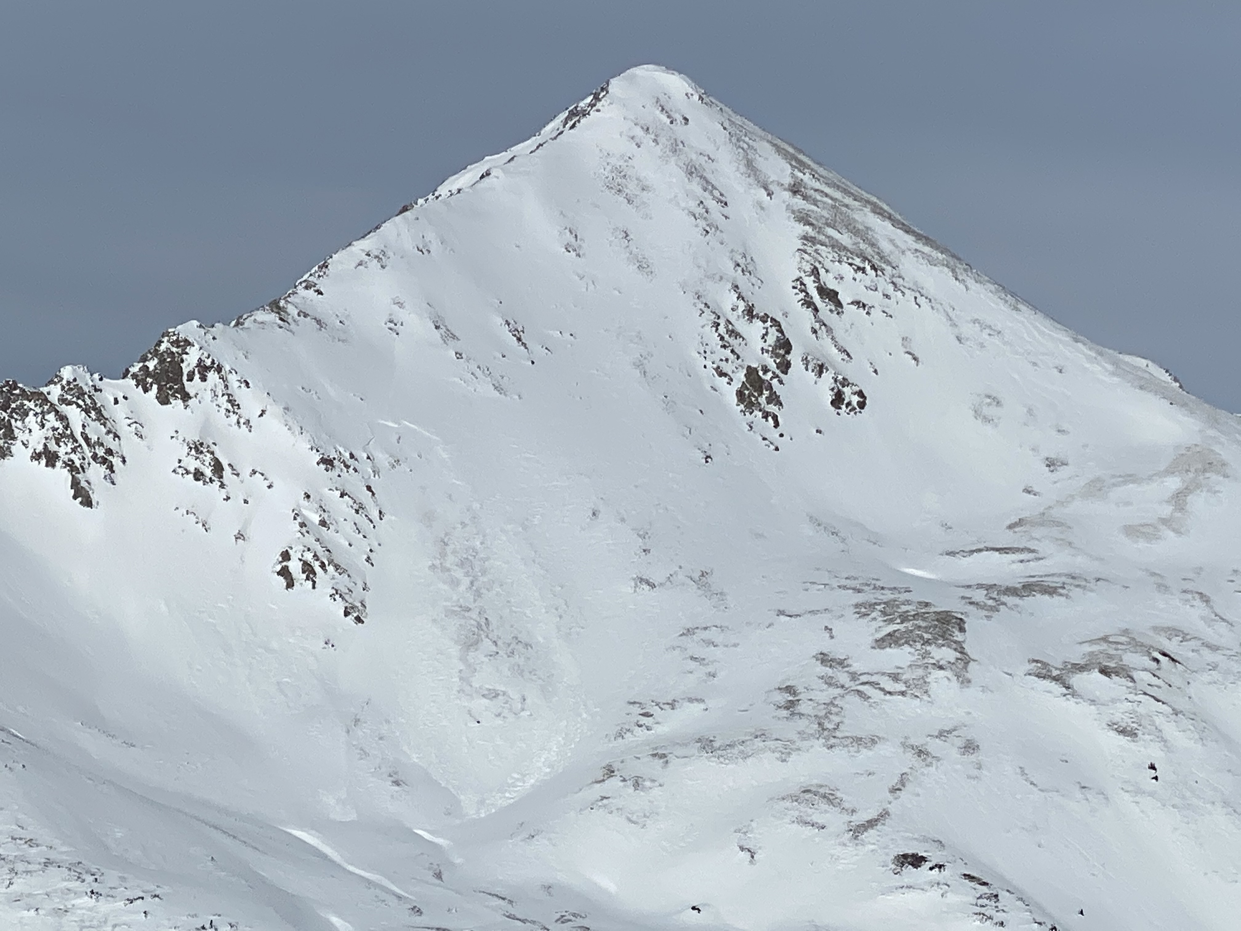
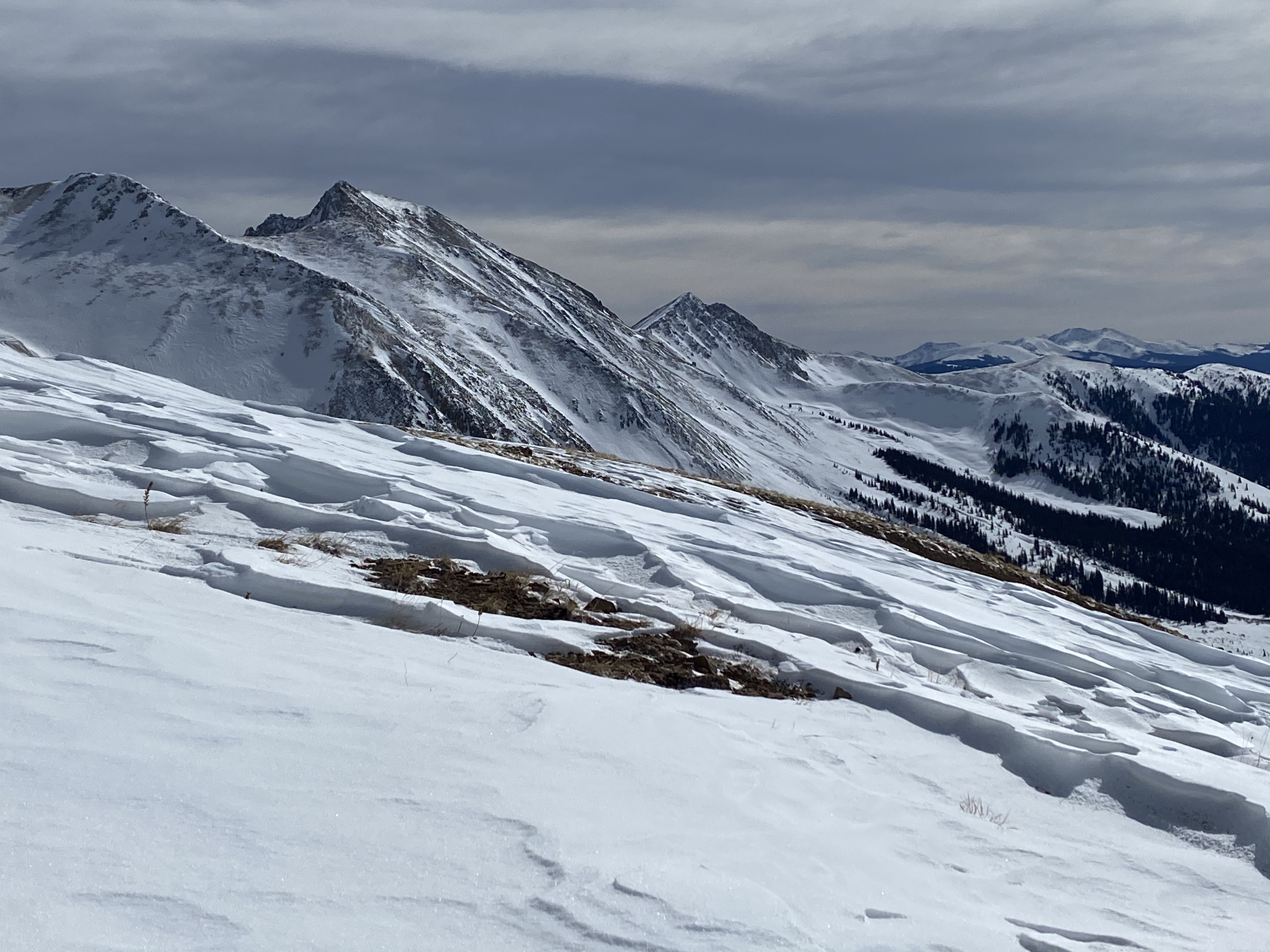
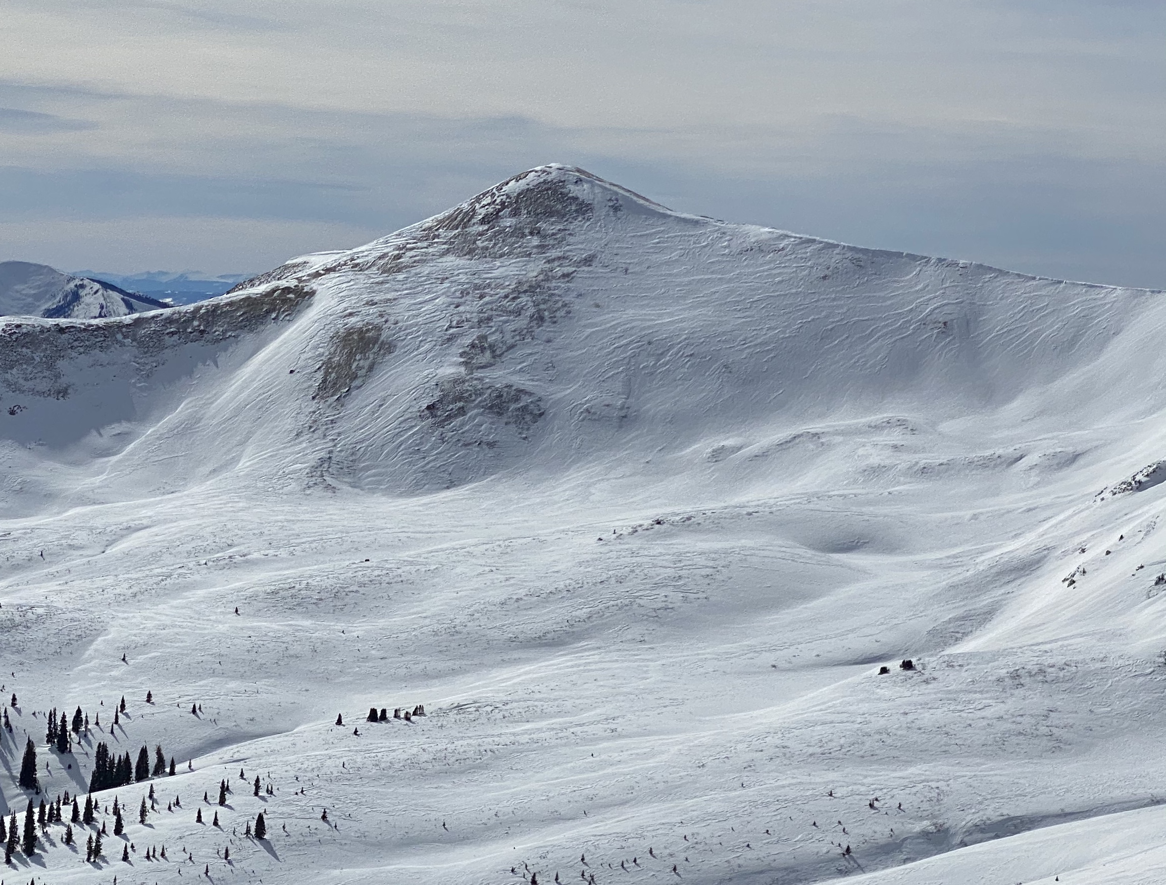
Subject: Poverty Gulch
Aspect: North East, East, South East, South
Elevation: 9,500-12,000

Weather: Partly Cloudy for the AM hours, and increasing to mostly cloudy in the PM hours. Periods of S-. Calm winds became a consistent moderate from the west northwest. New snow was not visibly blowing off the high peaks, but constantly saltating and drifting near the snow surface. Eric climbed in his goggles because his cheeks were apparently cold.

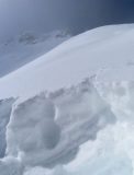
Snowpack: The new snow accumulation was 8″ at 9,600ft in Poverty Gultch. Traveling higher in the terrain, of course, those measurements became more variable with drifting. Drifts 1 to 2ft thick were encountered on wind-loaded terrain. Surprisingly very little instability was found in that new snow or at the old snow surface. Still, managing wind-loaded terrain for new Wind Slabs was the most common problem. We did kick off a couple very small Wind Slabs and chose to travel around some wind-loaded terrain features. The new snow was further becoming thicker throughout the day with the continued wind.

The Persistent Slab problem was considered on one slope that had an ugly terrain trap, and more regularly on very steep slopes that looked to have variable snow coverage through rocky terrain. The new snow had made no change or increased concern for the Persistent Slab Issue. We need a good loading event to collapse recently formed crusts and wind-board or to stress more deeply buried weak layers.
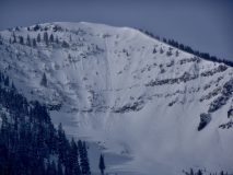
Cement Creek Snow

CB Avalanche Center2019-20 Observations

Location: Cement Creek Area
Date of Observation: 02/04/2020
Name: Cosmo
Subject: Cement Creek Snow
Elevation: 9400

Weather: ~3.5″ new snow since yesterday afternoon (as of 6am 2/4)

Mountain Weather For 11,000FT

CB Avalanche CenterWeather

Date: 02/04/2020

Yesterday’s storm came in on cue at about noon and dropped 2 to 5 inches across the forecast area. Winds, however, remain elevated yesterday afternoon and last night blowing the new snow around from the southwest. The low-pressure system stalled yesterday with the trough axis currently overhead. As the trough finally passes by, winds will make the shift to a more northerly direction late today. Air temperatures are quite cold across the forecast area close to the 0 mark. For today, light snowfall will linger across the highest terrain but is expected to produce just a few more inches. Winds will remain elevated until the trough axis finally moves eastward.

The atmosphere will briefly dry out on Tuesday night and Wednesday before a more exciting system impacts the area on Wednesday evening through about Friday. A wet northwest flow will set-up over Colorado which looks to include a strong jetstream and an Atmospheric River. The model runs has been reasonably consistent the past two days and the ample available moisture is clear. This system may offer the potential for snow to be measured in feet for the favored areas to the west and north of Crested Butte…..but the picture will become clearer over the next 24 hours.

  • Today

    High Temperature: 5 to 9
    Winds/Direction: 3 to 13, SE
    Sky Cover: Overcast
    Irwin Snow: 1 to 3
    Elkton Snow: 1 to 3
    Friend’s Hut Snow: 1 to 3

  • Tonight

    Low Temperature: -9 to -5
    Winds/Direction: 3 to 13, N
    Sky Cover: Mostly Cloudy
    Irwin Snow: 0 to 1
    Elkton Snow: 0 to 1
    Friend’s Hut Snow: 0 to 1

  • Tomorrow

    High Temperature: 8 to 12
    Winds/Direction: 8 to 18, NW
    Sky Cover: Overcast
    Irwin Snow: 0
    Elkton Snow: 0
    Friend’s Hut Snow: 0

Upper Slate River Valley

CB Avalanche Center2019-20 Observations

Location: Paradise Divide Area
Date of Observation: 02/03/2020
Name: Eric Murrow and Evan Ross
Subject: Upper Slate River Valley
Aspect: North, North East, East, South East, South
Elevation: 9000′ – 11350′

Avalanches: none observed

Weather: Snowfall started at about 1130 at the head of Slate River Valley. Accumulations reached about 2″ by 330pm at 9600′. While returning to trailhead at 4pm snowfall intensity ramped up to S2 for a short period presumably about the time of cold front passage. Winds blew 10 to 20 mph with occasional stronger gusts from the southwest. The new snow was easily transported around.

Snowpack: Ascended solar aspects and found substantial melt/freeze crusts on S and SE aspects up through high point at 11350′. Crusts on due south were up to 5cm and fairly hard supportive to skis. Southeast crusts were around 3cm thick. Even east aspects developed thin, soft melt/freeze crusts this past weekend. South and southeast aspects through 11300′ do not look to pose a problem without a major loading event.

Poked around on a northeast-facing slope at 11300 that is susceptible to wind impact and found a snow height a bit over 200cm. Around 30cm deep, there were two interfaces that produced planar results but did not propagate in long column test; failures were on lightly faceted grains. The midpack at this location lacked any concerning interfaces and was quite dense up to pencil hard. Only superficially examined lower snowpack, but no obvious weakness was present while probing.

Mountain Weather For 11,000FT

CB Avalanche CenterWeather

Date: 02/03/2020

Today will start out with mild temperatures and gusty southwest winds. Cloud cover will continue to build early this morning ahead of the low-pressure system just to our west in Utah. Model runs continue to show modest snow accumulations with possibly a few short bursts of heavy snow during frontal passage. Snowfall totals today will range from 3 to 5 inches across the forecast area. Winds will be strong up high through the middle part of the day from the southwest but will relax once the flow turns to the northwest in the afternoon. Expect high temperatures to happen early in the day before the passage of the front. Snowfall will begin just before lunch and continue through about sunset. Snowfall after sunset will be light and favor areas in the Ruby range as the flow turns northwesterly.

Snowfall will linger into Tuesday under northwest flow but accumulations look light. Wednesday looks to be a dry day before a moist northwest flow sets up over Colorado for the second half of the week. This system might produce healthy accumulations for areas to the west and north of town that are best situated for northwest flow events from about Thursday through Saturday. Let’s all do a snow dance, cross our fingers and toes then maybe the system at the end of the week will provide a few legitimate powder days!

  • Today

    High Temperature: 23 to 27
    Winds/Direction: 15 to 25, G50 SW transitioning to NW in afternoon
    Sky Cover: Overcast
    Irwin Snow: 3 to 5
    Elkton Snow: 3 to 5
    Friend’s Hut Snow: 3 to 5

  • Tonight

    Low Temperature: -4 to 0
    Winds/Direction: 5 to 15, WNW
    Sky Cover: Overcast
    Irwin Snow: 0 to 2
    Elkton Snow: 0 to 2
    Friend’s Hut Snow: 0 to 1

  • Tomorrow

    High Temperature: 4 to 8
    Winds/Direction: 5 to 15, E
    Sky Cover: Mostly Cloudy
    Irwin Snow: 0 to 1
    Elkton Snow: 0 to 1
    Friend’s Hut Snow: 0 to 1

Warm and sunny

CB Avalanche Center2019-20 Observations

Location: Paradise Divide Area
Date of Observation: 02/02/2020
Name: Eric Murrow
Subject: Warm and sunny
Aspect: East, South East, South, South West, West
Elevation: 9000′ – 10800′

Avalanches: A little family of small loose avalanches on southeast aspect of Cascade below treeline coming out of a steep rocky area. I would guess they ran on Saturday.

Weather: It was a warm balmy day with light winds below treeline. Occasional plumes and flagging were visible throughout the day off ridgetops and peaks, but no real loading.

Snowpack: By about noon old surface crusts had broken down from temps and solar on southeast and south aspects. Did not see any fresh loose avalanche activity today through about 230pm. Riding conditions became quite nice on sunny slopes below treeline. Skied and snowmobiled numerous small test slopes below treeline without any results other than some very minor roller balls.

Photos:

Friends Hut Obs.

CB Avalanche Center2019-20 Observations

Location: Brush Creek Area
Date of Observation: 01/30/2020
Name: Tom Schaefer
Subject: Friends Hut Obs.
Aspect: East, South East, South, South West, West
Elevation: 9000-12000

Avalanches: Observed one small shallow wind slab 50′ X 100′ that ran sometime the night or morning of the 30/31 off Carbonate peak SE aspect 12,200′.

Weather: Clear becoming OVC over three days with a trace of snow the night of the 30th. Temps averaged in the teens with moderate winds at lower elevations and strong N winds aloft.

Snowpack: Lower elevations had an avg HS around 60-90 cm’s. Generally a very weak faceted snow pack with sun crusts forming on solar aspects. Snow surfaces remained cold and dry. Snow bridges up to hut in good shape.
Higher elevations in Star basin was a mixed bag that was becoming ravaged by the winds up high. Skied W-S-E aspects. Only observed snow pack lower in the basin avoiding the winds up high. Looked like lots of sastrugi ATL. NTL HS ranged from 60-130 cm’s. No signs of instability observed. W aspect weak faceted snow pack , S aspect pretty much the same with several weak crust layers mixed in there, E aspects pretty much the same? Surface hoar observed in sheltered shady areas NTL.


Mountain Weather For 11,000FT

CB Avalanche CenterWeather

Date: 02/02/2020

Today looks to be the last day of mild and pleasant weather before an approaching trough begins to impact the area on Monday. The thin, high clouds from the past two days look to diminish which will allow high temperatures to reach well above seasonal norms today. Winds are expected to remain reasonable, blowing 10 to 20 mph, as they swing to the southwest before the next weather maker arrives.

Clouds will increase quickly on Monday and snowfall should start during the first half of the day for the Crested Butte area. Snowfall totals do not look impressive but a cold front passage midday will help to squeeze out the snow. Air temperatures look to drop throughout the day tomorrow to levels well below seasonal norms.

  • Today

    High Temperature: 36 to 40
    Winds/Direction: 10 to 20, SW
    Sky Cover: Mostly Clear
    Irwin Snow: 0
    Elkton Snow: 0
    Friend’s Hut Snow: 0

  • Tonight

    Low Temperature: 16 to 20
    Winds/Direction: 15 to 25 G40, SW
    Sky Cover: Mostly Cloudy
    Irwin Snow: 0
    Elkton Snow: 0
    Friend’s Hut Snow: 0

  • Tomorrow

    High Temperature: 23 to 27
    Winds/Direction: 10 to 20, SW
    Sky Cover: Overcast
    Irwin Snow: 3 to 5
    Elkton Snow: 3 to 5
    Friend’s Hut Snow: 3 to 5

Cement Mountain tour

CB Avalanche Center2019-20 Observations

Location: Cement Creek Area
Date of Observation: 02/01/2020
Name: Eric Murrow
Subject: Cement Mountain tour
Aspect: North, North East, West, North West
Elevation: 9000′ – 12200′

Avalanches: None observed

Weather: Cold valley bottoms in the morning gave way to moderate air temps by mid-day at all elevations. Winds were very light even above treeline, very comfortable conditions in the alpine. Thin, high cloud cover all day – filtered sunshine.

Snowpack: Surface Hoar was present on all open slopes on the north half of the compass from valley bottom straight to the top at 12200′.

Below treeline shaded terrain showed a snow height between 60cm and 80cm. Ski penetration ranged from 20cm to 35cm, boot penetration was to the ground. There is just enough strength in the top half of the snowpack for reasonable skinning and marginal riding but generally too weak for much of a slab avalanche problem below treeline.

As soon as we walked above a large drifted slope, we produced a collapse. This collapse failed in the middle of the snowpack on a very weak faceted layer capped with surface hoar. Test results at a nearby location produced CT5 SC & ECTP11 results failing in the middle of the snowpack beneath a slab that has been building over the past month. Slab hardness was up to 1 finger. see photo

Briefly poked into a northwest-facing feature at 12000′ and again found a weak snowpack that struggled to support skis with an HS at 9ocm – riding conditions were trap-door.

Alpine terrain on Cement Mountain was not nearly as wind-blasted as other parts of upper Cement and Brush drainages.

Photos:

Wind havoc and taylor slide

CB Avalanche Center2019-20 Observations

Location: Cement Creek Area
Date of Observation: 02/01/2020
Name: Tim
Subject: Wind havoc and taylor slide
Aspect: East, South East, South, South West, West
Elevation: 12,800

Avalanches: Observed what seemed to be a fairly recent persistent slab on a south aspect of Taylor peak at around 12,800

Weather:

Snowpack: Generally thin, or non existent, rotten and wind hammered. The good stuff


Photos: