The Lion Roared

CB Avalanche Center2020-21 Observations

Date of Observation: 02/06/2021


Zone: Northwest Mountains
Location: Slate
Aspect: North, North East
Elevation: Treeline to below treeline


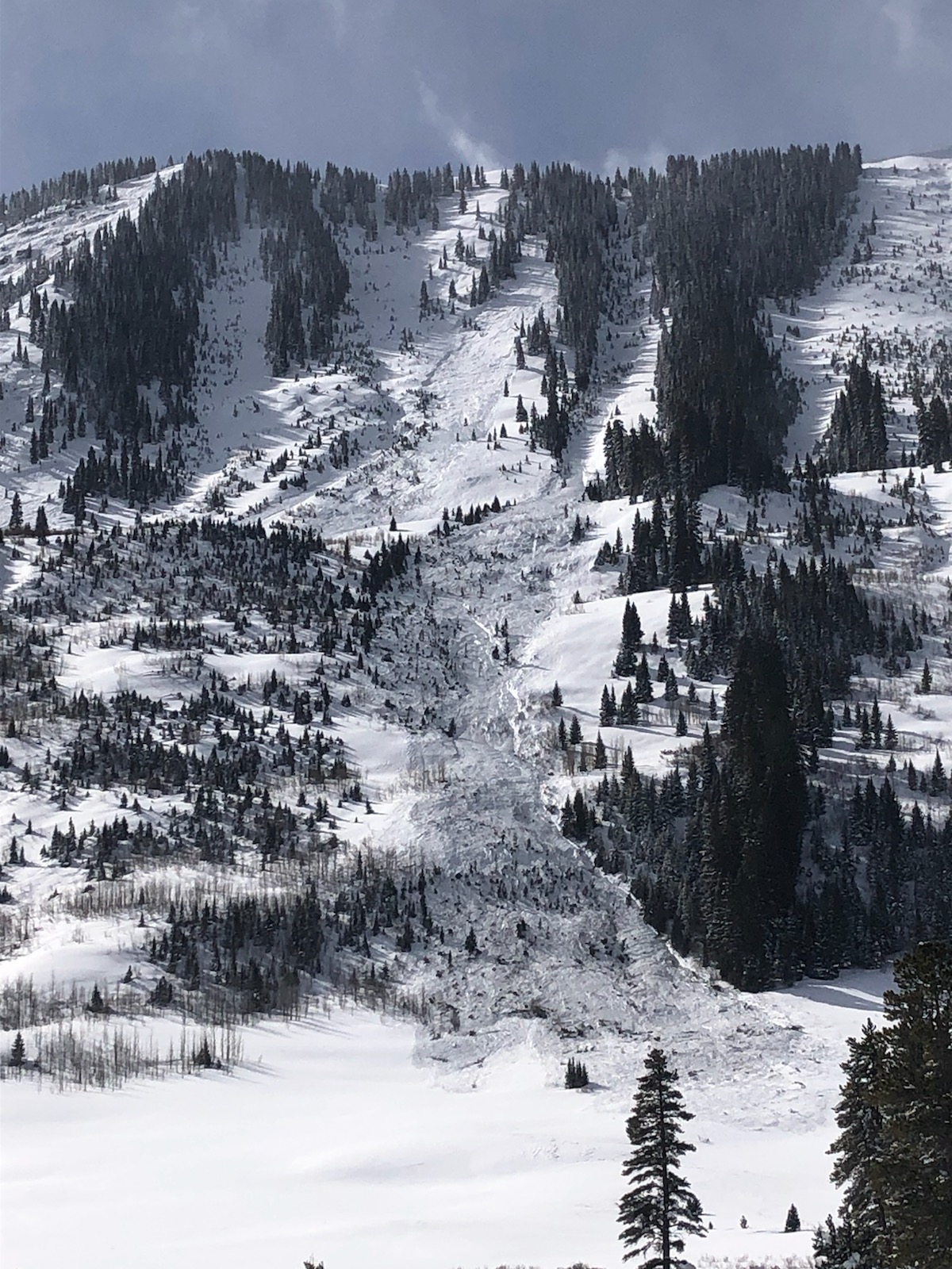
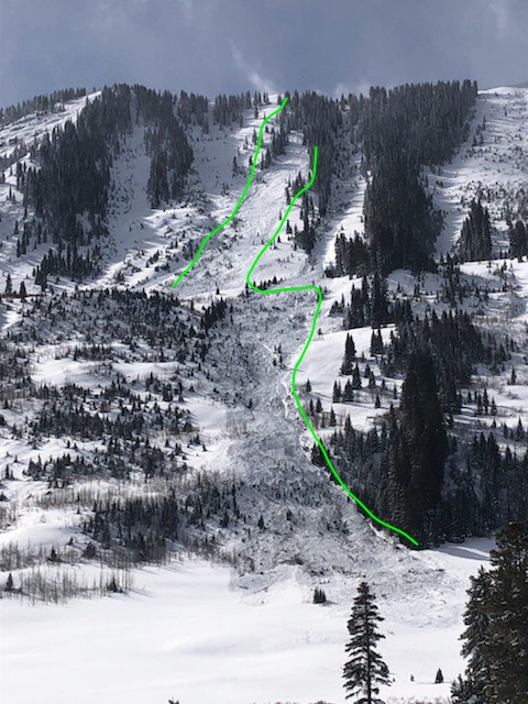
Avalanches: Too many to count. From Climax Chutes, all along Schuykill Ridge around the corner to north facing aspects above Daisy Creek. Climax release snapped a tree 2 feet in diameter by the River Flats bathroom and left powder cloud debris on the Slate road (light snow, pine needles and some branches). Releases from the high basin above the town of Pittsburgh from numerous aspects left a considerable amount of debris on a large bench area adjacent to the top of the “rollers.” I’ve included just a few examples of the carnage.
Weather: Nice, warming, light snow off and on
Snowpack: 8 inches new overnight and plenty of evidence of wind but not in protected areas. No sign of instability in a low angle slope that has seen plenty of traffic all season long.


Photos:

SE to NW transition zone goes off

CB Avalanche Center2020-21 Observations

Date of Observation: 02/06/2021
Name: Zach Kinler
Zone: SE/NW mountains

Avalanches: Many large and widely propagating avalanches were observed during a brief clearing that allowed views of Mt. Emmons, Gothic, Belleview, Schuylkill and Redwell. Leeward aspects in this “transition zone” from our SE mountains to our NW mountains finally tipped with the most recent round of snow and wind. A few of these avalanches propagated entire paths as well as connecting multiple paths at a time. Impressive slides!
Weather: Blustery NW flow, 5″ HST in town. Snow and wind gave way to some clear skies around and just west of town allowing for views into the nearby alpine.

Photos:


Two broad avalanches on Mt. Emmons

CB Avalanche Center2020-21 Observations

Date of Observation: 02/06/2021
Name: Ben Pritchett
Zone: Northwest Mountains
Location: Red Lady Bowl and Coon Basin
Aspect: South East
Elevation: ~12,000′

Avalanches: Two SS-N-R3/D2.5-O avalanches

1x SS-N-R3/D2-O, East below treeline Mt Emmons(Red Lady Glades, repeater in the fishbowl)


Tender is the Bush: Below Tree Line Persistent Slab

CB Avalanche Center2020-21 Observations

Date of Observation: 02/05/2021
Name: Jared Berman and Zach Guy


Zone: Southeast Mountains
Location: Traveled up ridge on west side of West Brush Creek to Point 10,607. Descended East facing glades back down to West Brush Creek.
Aspect: East, South East
Elevation: 9500′-10600′


Avalanches: Ski triggered one small persistent avalanche remotely on a steep east facing terrain feature well below treeline at 9800′. See photo below.  Light was very flat but we could see several natural D1.5 persistent slabs that likely ran during Wednesday night’s storm below treeline on east aspects.
Weather: Overcast skies with temperatures in the 20s and very light snowfall that increased throughout the day.
Snowpack: Widespread collapses and shooting cracks on east aspects and flat terrain.  Snowpack is weak and shallow below treeline around Brush Creek. Snowpack averages 90cm at 10,000 ft in this zone. On east facing terrain, slabs are 40cm thick (F to 4F-) on top of well developed faceted fist hard grains down to the ground.  An extended column test produced moderate results (ECTP11). Southeast terrain below treeline also contained a 40cm slab but it is interrupted by a 5cm meltfreeze crust (2/3 crust) and is resting on top of a supportive crust. Test slopes were not reactive to the weight of a skier.  Due to shallow coverage in the terrain we traveled, the slabs are still anchored by brush and hummocky terrain features on some slopes, so the easily triggered collapses and shooting cracks didn’t always result in avalanches.  Steep, open terrain facing east or northeast with smooth underlying ground cover feels like a sure bet for triggering a slide.


Photos:


Cold and quiet

CB Avalanche Center2020-21 Observations

Date of Observation: 02/04/2021
Name: Con Rad

Zone: Southeast Mountains
Location: It’s a secret stash that no one knows about
Aspect: North East
Elevation: 10,400

Avalanches: Saw one in the furthest west gully on Gothic and some on N and NE facing steeper shots on Schyukill but viz was somewhat hampered by in and out light.

Weather: Lightly snowing off and on some winds from SW that was transporting snow. But I’m no meteorologist.

Snowpack: Ski pen 8″, no signs of instability where we were skiing. Seemed like the wet and warm start to the storm pasted into old tracks and then the cold dry snow finish was what we were skiing in. It also seemed like the wind blew up the slope and then down the slope. Or down the slope and then up the slope. Like I said, I’m no meteorologist.

Whetstone

CB Avalanche Center2020-21 Observations

Date of Observation: 02/04/2021
Name: Emilio Alcala

Zone: Southeast Mountains
Location: Whetstone Big Bowl
Aspect: North East
Elevation: 12,500

Avalanches: NE face Big bowl, Large Avalanche D2.5? R2
Weather: Clear morning following large loading event high winds yesterday and significant snowfall

Photos:

6″ up Cement Creek

CB Avalanche Center2020-21 Observations

Date of Observation: 02/04/2021
Name: Cosmo Langsfeld

Zone: Southeast Mountains
Location: Cement Creek Ranch
Elevation: 9250′

Weather: At 9pm there was 3″ at the trailhead and 4″ at the ranch. An additional 2″ fell at the ranch overnight.

Cement Creek Snow

CB Avalanche Center2020-21 Observations

Date of Observation: 02/03/2021
Name: Cosmo Langsfeld


Zone: Southeast Mountains
Location: Cement Creek Ranch
Aspect:
Elevation: 9250′

Weather: Just a skiff of new snow at 5:30am. Snowing lightly.


Westwall

CB Avalanche Center2020-21 Observations

Date of Observation: 02/01/2021
Name: Zach Guy

Zone: Northwest Mountains
Location: Irwin Upper Upper Westwall
Aspect: West
Elevation: N/ATL

Avalanches: Nothing new since the slides reported yesterday.
Weather: High thin clouds increased in thickness through the day. Mild temps. Light winds.
Snowpack: Explosive testing on upper elevation west-facing terrain with relatively minimal snow safety work this season. No results. Probing revealed discontinuous and isolated persistent slab structures across the terrain, due to previous wind erosion. Anything with a hint of south had a thin, melt freeze crust on the surface after yesterday’s warmup. Crusts did not soften today. Measured 1.6” Storm SWE in a relatively sheltered near treeline slope.