Large Natural Slab Avalanche in the Anthracites

CB Avalanche Center2014-15 Observations

Name: Zach Guy
Title: Large Natural Slab Avalanche in the Anthracites
Location: Kebler Pass Area
Date of Observation: 12/15/2014
Aspect: East
Elevation: NTL

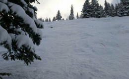
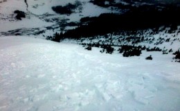
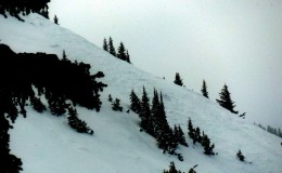
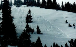
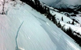
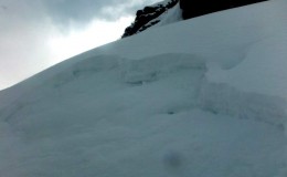
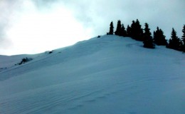
Avalanches: Investigated the slide in East Bowl. Crown averaged roughly 45 cm thick, up to an estimated 90 cm. The slab was 1F- at the bottom up to Fist at the top. It failed on the Dec 13th NSF layer, (1-2mm facets, Fist hard). It was about 800 feet wide and ran 500 vertical. Start zone at 10,900 feet, east-facing aspect. SS-N-R3-D2-I

Uploads:

Video here:

Crested Butte Area

CB Avalanche Center2014-15 Observations

Name: Dodson Harper
Title: Schuykill Ridge
Date of Observation: 12/14/2014
Aspect: North East, East
Elevation: 11,000′

Avalanches: Human triggered soft snow avalanche on the nose of November Bowl. Approximately 75′ wide and ran 400′. On the upper part of the run, it stepped down to the ground carrying all faceted snow with it. The slide was large enought to knock one skier down, but they were not buried (and no injuries). We saw small sluffs from skiing all day but only this one ran very far.

Uploads:

December 15, 2014

CB Avalanche CenterWeather

Date:

The low pressure system responsible for our resent stormy weather has moved on to Kansas. Orographic snowfall will linger the longest in the western portion of the zone but will otherwise diminish through the day. Moisture is being pulled out of the area and a ridge is approaching from the west making for dryer condition this afternoon. The resent weather system has been complicated and the remainder of the week is looking the same. Forecast models still need to come into agreement, through we can expect overcast skies and chances for light snow through the week.

Schuykill Ridge

CB Avalanche Center2014-15 Observations

Name: Zach Guy
Title: Schuykill Ridge
Location: Paradise Divide Area
Date of Observation: 12/14/2014
Aspect: North East, East
Elevation: NTL/BTL 11,400 to 9,200 ft.

Avalanches: Several human triggered and one natural loose avalanche that gouged into old snow and ran up to 1,200 vertical feet. Debris piles 3-5′ deep. (L-AS/N-R1-D1/1.5-O). Also skier triggered several soft slabs below ridgelines that failed on the Dec 13th NSF, and ran far, gouging into older snow. Most of these were 30-40 feet wide, but one was almost 200 feet wide, and ran about 1,000 vertical. (SS-ASc-R1-D1/1.5-I)

Weather: Moderate W/NW winds with strong gusts. Periods of moderate snow transport. Mostly cloudy with intermittent flurries (S-1) through the day. Cold temps.

Snowpack: Toured in the Western part of Schuykill Ridge, near Pittsburg. 2″ of storm snow evenly distributed across the terrain, over the Dec 13th near surface facet layer. Not enough for slab formation, except for below ridgelines and a few wind affected features, where winds had drifted the new snow into 3-6″ of a more cohesive slab. Anywhere that a slab had formed, it was very touchy underfoot.

Uploads:

December 14, 2014

CB Avalanche CenterWeather

Date: 12/14/2014

Last nights disturbance is moving out of our area for tacos in New Mexico. We would see a drying trend due to this, but as the trough axis shifts east this morning we’ll be moving into northwest flow. This northwest flow will produce lingering orographic snow showers for our area through the day. The Western portion of our zone, Irwin, Paradise Divide and Schofield will see the best chance for continued snowfall today and into tonight. Any lingering showers should be diminishing by Monday morning. Unsettled weather returns for Wednesday night through Thursday but isn’t looking to impressive at this time.

Peeler Basin and Oh-Be-Joyful Basin

CB Avalanche Center2014-15 Observations

Name: Zach Guy
Title: Peeler Basin and Oh-Be-Joyful Basin
Location: Kebler Pass Area
Date of Observation: 12/13/2014
Aspect: North, North East, South
Elevation: 9,700′ to 12,200′

Avalanches: Shallow facet sluffing on anything northerly facing. Nothing impressive, except for the one guy in our group who crashed in front of his sluff and got pummeled.

Weather: Clear skies all morning. Clouds began developing around 2 p.m. Warm temps, moderate SW winds. No precip.

Snowpack: More of the same. South aspects near treeline had wet grains (facets and meltforms) to the ground, HS around 30-40cm. North and northeast facing slopes above treeline held a continuous layer of ~3″ of near surface facets (fist hardness), sitting over a variable distribution of old, stiff snow or weak, unsupportive snow. Descending in elevation, the snowpack transitioned to mostly all facets and unsupportive on skis. See video

Crested Butte Area

CB Avalanche Center2014-15 Observations

Name: TNA
Title: confectionery
Date of Observation: 12/13/2014
Aspect: North, North East
Elevation: BTL

Avalanches: None seen

Weather: Warm, sunny, no wind

Snowpack: Skied 800 vertical feet of factus awesomnus in 2.5 bowl Snodgrass. You ain’t livin’ until you’re skiing facets. Although, about midway down there was some sort of 4 inch thick supportable layer out in the open shots about four inches down in the pack. Windboard?

Saturday 12/13 Weather

CB Avalanche CenterWeather

Date: 12/13/2014

As of 6am, the much anticipated cold front is racing across the Utah desert. This north-south oriented cold front will break the 20-day long drought and bring significant snowfall to the Elk Mountains. Look for the storm to begin warm and wet, and steadily cool off throughout the weekend. South winds average 25-30 mph this morning with stronger speeds above treeline, then wind will decrease this afternoon after the cold front passage around 3pm. Tonight will be the heaviest shot of snow as the winds aloft veer from southwest to westerly, funneling moisture into the Crested Butte area. Sunday we will see continued snow, with forecast models still hinting at total storm accumulations in the 8-14″ range by Monday morning.

Mt. Owen

CB Avalanche Center2014-15 Observations

Name: Zach Guy
Title: Mt. Owen
Location: Kebler Pass Area
Date of Observation: 12/12/2014
Aspect: North, North East, East
Elevation: 11,000 – 13,000 ft

Snowpack: For ATL slopes over a week out since last snow, the snow surface is remarkably unscathed by wind. The Dec 1 snowfall has metamorphosed to rippled near surface facets (~3″ thick), over older, stiff windboard. Isolated gulley features have a thin windcrust over the NSF. Breakable MF crust as the aspect changes to ESE. No signs of instability on slopes up to 45 degrees, except for shallow facet sluffing, enough to require heads-up sluff management. Can’t recall the last time I saw such a widespread PWL so well preserved on the surface at all elevation bands here in CB.

Schuylkill Ridge 12-11-14

CB Avalanche Center2014-15 Observations

Name: Dustin Eldridge
Title: Schuylkill Ridge 12-11-14
Location: Paradise Divide Area
Date of Observation: 12/11/2014
Aspect: North, North East, East
Elevation: 9000-11300

Avalanches: None observed.

Weather: Warm and calm. Light high elevation clouds. Snow surface was moistened on southerly aspects.

Snowpack: Low elevations held almost entirely faceted snow on shaded slopes with slightly more consolidated pack on NE faces. Crust softened by the midday sun was evident on S-facing slopes up high. Facets abounded under the crust, snow height around 40-50 cm. Pit dug on N-aspect , 37 degrees, 11,300 ft, showed 75 cm of snow with Fist-hardness (2-3 mm faceted crystals) down to 50-60 cm. From there the pack was slightly stiffer (4f, 1mm wind compacted)) down to about 5 cm (2-3 mm facets) where a depth hoar layer was evident. Extended column test showed ECTP 18, Q2.5 on the ground.