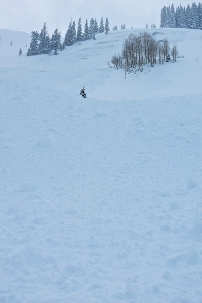
Mountain Weather December 31, 2014

CB Avalanche CenterWeather

Date: 12/31/2014

It’s a chilly -8F in town this morning, but mountain temperatures will rebound nicely ahead of a closed low moving along the California coastline towards Arizona today. The San Juan mountains will catch most of the snowfall from this cyclone, but a couple inches of snow should begin accumulating in our mountains by New Year’s Day. As the system rotates east, we’ll see showers dwindle before we return to northwest flow through the weekend.
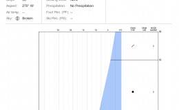
Crested Butte Area

CB Avalanche Center2014-15 Observations

Name: Evan Ross
Location: Conies, Washington Gulch
Date of Observation: 12/30/2014
Aspect: North East, East
Elevation: 9,900-10,900

Weather: Overcast, a few vary light snow flurries, cold, calm wind.

Snowpack: At the top of the bowl in the middle/open area, found a 10-12″ wind slab on top of lower density storm snow that didn’t produce any results while skiing. Most upper sections of the bowl had a nice supportive persistent slab with boot top ski pen. Lower areas of the bowl the slab with both thiner and softer. In this lower half we got numerous collapses and shooting cracks. One collapse while skinning up the skiers left side of the bowl remote triggered a D2 persistent slab from 600ft away. In this area the persistent slab was reactive on the 12/13 interface and below this interface was generally one layer of weak facets to the ground. HS for the lower and weaker sections of the bowl was 70-90cm, while up higher in the bowl the HS was 100-120cm.

Avalanches: While skinning, remote triggered a D2 persistent slab from 600ft away. SS-ASu-R1-D2-O. Likely failed on the 12/13 weak faceted interface and gouged through more weak facets to the ground. Crown was 2-3ft tall, 160ft wide and debris ran about 700ft in length. Start zone slope angle estimated between 36-38 degrees.

Uploads:

IMG_0147

SS-ASu-R1-D2-O. Likely failed on the 12/13 weak faceted interface and gouged through more weak facets to the ground.

IMG_0146

Crown was 2-3ft tall, 160ft wide and debris ran about 700ft in length.

IMG_0136

Anthracites

CB Avalanche Center2014-15 Observations

Name: Kirk Haskell
Title: Anthracites
Location: Kebler Pass Area
Date of Observation: 12/30/2014
Aspect: North East
Elevation: 11,ooo ish

Avalanches: no recent signs

Weather: Winds gust from SW 15-20 Mph starting to clam around 2pm

Snowpack: About a 6″ windslab at the top wind transporting snow to NE facing sides . Went half way up to top of Rock and Tree chute and decided to abort since we were experiencing shooting cracks and whomphing .

Uploads:

California Love

CB Avalanche Center2014-15 Observations

Name: Jafar Tabaian
Title: California Love
Location: Crested Butte Area
Date of Observation: 12/30/2014
Aspect: East
Elevation: 10,500

Avalanches: Skied skiers right shot of California bowl on Snodgrass. Set of a soft slab avalanche on aggressive ski cut towards top flank of the slope. Approximately 30 cm (12 in) crown that slid on December dry-spell sun crust. East facing slope that was 35-40 degrees. Purposely ski cut the flank of the slope to test it before we skied so it was D1.5 and R1, but I think the entire face would have gone if we had ventured out on to the main zone, which would likely have resulted in a D3 and R4 avalanche. Did not step down into persistent layer, which seemed to be very facet (rotten) ridden. Based on what I’ve seen the past few of days on Snodgrass I would ski very conservatively across the zone. We retreated to the trees and it skied great without additional signs of instability.

Weather: Overcast. S1, very light snow towards sunset. No wind. Lots of dogs.

Snowpack:

Uploads:

Cali-Bowl-2
Cali-Bowl-1

Explosive-triggered avalanches at Irwin

CB Avalanche Center2014-15 Observations

Name: Zach Guy
Title: Explosive-triggered Avalanches at Irwin
Location: Kebler Pass Area
Date of Observation: 12/30/2014
Aspect: West
Elevation: 11,800 feet

Avalanches: Handshots and airblasts triggered 2 sizable persistent slabs on west aspects above treeline, failing 1.5 to 2 feet deep on facet layers near the ground (the Dec 13th interface and gouging through all old snow below it). Both slides were roughly 150 feet wide and ran 900 vertical feet, Debris piles looked to be 5 to 8 feet deep. D2 to 2.5 in size. SS-AE/AB-R2-D2/2.5-O

Uploads:

Mountain Weather December 30, 2014

CB Avalanche CenterWeather

Date: 12/30/2014

Light snow and cold temperatures will continue today. A broad low-pressure trough is elongated across the southwest states, with an arctic airmass over Colorado. Winds remain mercifully light as the jet stream stays to our south. The arctic airmass moves east on Wednesday issuing out the cold temperatures. A closed low will begin moving across Arizona and New Mexico over the next few days, rotating moisture into southwestern Colorado under a South to Southeast flow. This pattern tends to be unfavorable for our mountains, but lets hope we see more than a few inches stack up by the end of New Year’s Day.

Red Lady

CB Avalanche Center2014-15 Observations

Name: Travis Colbert
Title: Red Lady
Location: Kebler Pass Area
Date of Observation: 12/29/2014
Aspect: South East
Elevation: 12,300

Avalanches: The final (and steepest) rollover prior to the lap track released a very small slab (4-5 inches deep, 10 feet wide, ran about 20 feet).

Weather: Intermittent light snow; light but steady winds from the west. Partial clearing at times, then socked in again. Cold (8-10 degrees).

Snowpack: Snowpack was solid despite some wind transported snow in the bowl. Very soft, 2-inch unconsolidated wind slab in the bowl. Broke off a small section of the cornice with no results. Ski cut broke up the soft surface slab, but produced no significant results. All of the tracks from weekend were completely covered by the new snow and wind transported, recycled powder. Bowl skied perfectly; creamy soft powder turns all the way down. Went up for a second lap, but visibility dropped considerably at the summit. Skied fluffy powder through the glades all the way down to the road.

Uploads:

Crested Butte Area

CB Avalanche Center2014-15 Observations

Name: Will Dujardin
Location: Snodgrass Weather Station Pits 12-28-14
Date of Observation: 12/28/2014
Aspect: North East
Elevation: 11120

Weather: Light snow and low clouds, very light wind.

Snowpack: We dug two pits just approx. 3.5 feet deep to the ground right next to each other on slightly different slopes (30 degrees and 37 degrees) on the NE aspect just below the weather station. We isolated two blocks to test the storm snow and the persistent slab in both pits. The 18~” of storm snow sluffed away in both pits to shovel taps. The 30 degree pit we were able to get the isolated persistent slab to go with applied boot pressure, in the 37 degree pit we had the storm slab (just above the top of the shovel in photo 1) go with a single skicut to the back, like a Rutschblock test of sorts, and the persistent slab to go with a boot kick in the same spot. See attached photos to see what the ski cut did in the 37 degree pit. It seems like it’s definitely harder, but not that hard, to trigger that persistent slab, and the slab formed from the recent storms is very touchy, it could definitely knock you down or bury you in a terrain trap, and if it stepped down to the persistent slab it would result in a massive avalanche . We skied back the low angle E-SE aspects to avoid the NE avalanche problem. Sorry for the lack of technical terminology!

Uploads:

Mountain Weather December 29, 2014

CB Avalanche CenterWeather

Date: 12/29/2014

A winter weather advisory was issued for our area. Last night we received light snowfall and are anticipating the snowfall to increase today. Northwest and southwest winds are converging along with a cold front and creating a band heavier snowfall in northern Colorado. This band will continue moving south today but the big question is weather all these things line up over the Elk Mountains as this system move south. If so, we’ll see the higher end of snow forecast numbers and if not, we’ll see continued light snowfall. The western portion of our zone should do ok either way with favorable orographics. We’ll see lingering snowfall on Tuesday as this weather system splits off to the south and shows some love for the San Juan Mountains. Wednesday will be drier with more weather anticipated on Thursday.