Natural avalanche on Gothic east face

CB Avalanche Center2016-17 Observations

Location: Crested Butte Area
Date of Observation: 12/29/2016
Name: Frank Stern
Subject: Natural avalanche on Gothic east face
Aspect: East
Elevation: 12,000

Avalanches: Natural release on east face of Gothic at 12,000′. Appeared to start below cliff in sun, ran over cliff approximately 200′ airborne. Snow continued to run for about 10 minutes. N-U-R2-D2+.
Weather: Sunny, 25 F
Snowpack:

Deep snowpack and mid-pack facets healing

CB Avalanche Center2016-17 Observations

Location: Paradise Divide Area
Date of Observation: 12/29/2016
Name: Zach Guy
Subject: Deep snowpack and mid-pack facets healing
Aspect: North East, East, South
Elevation: 9600-12100

Avalanches: Extensive views from the Ruby Divide and did not see any fresh avalanche activity since the Christmas storm. I checked out the crown of the Schuylkill Ridge avalanche that ran around Christmas. It failed ~40cm deep on a layer of .5 – 1.0 mm near surface facets (Dec 22nd interface). This interface appears to be rounding and gaining strength, no significant hardness change or size change from the slab above, and non-propagating ECT results. The avalanche was SS-N-R3-D2-O. There were several other similar slides in adjacent paths. These bed surfaces hold a shallow, faceted snowpack now.
Weather: Clear. Light winds.
Snowpack: Snow depth consistently 230cm+ on various aspects/elevations except in obvious wind scoured locations. Dug 3 pits down to Dec 22nd interface and found it to be unreactive in extended column tests, anywhere from 70cm to 30cm deep, MFcr over rounding facets on southerly ATL, and rounding near surface facets on northerly N/BTL. No surface hoar observed in any pits, even in a suspect wind sheltered slope BTL. Wednesday’s wind event left shallow (less than 6″) but stiff drifts on obvious features. Stomped on a few of these and only produced minor cracking.  No other signs of instability.

Stubborn/unreactive wind drifts in specific locations, easy to avoid.

12/25 Schuylkill slide snapped a few small trees

Crown is mostly drifted over now. Very wide propagation

Avalanche appeared to fail about 40 cm deep on buried near surface facets.

Mountain Weather 12/29/2016

CB Avalanche CenterWeather

Date: 12/29/2016

One of those classic Colorado bluebird days will be on tap today, decreasing westerly winds at ridge top, and although a cold start to the morning, should warm up nicely into the mid to upper 20s at 11,000ft. We can expect clear skies into Saturday morning, before high clouds stream into our area in the afternoon. An active pattern of snow and cold gets 2017 off on the right foot for the weekend into early next week.

Paradise Divide Area

CB Avalanche Center2016-17 Observations

Location: Paradise Divide Area
Date of Observation: 12/28/2016
Name: Briant Wiles
Subject:
Aspect: East
Elevation: 11,000

Avalanches:
Weather: Overcast with periods of light snow. Calm to light winds out of the west mid day becoming stronger and gusty in the afternoon. Robust snow transport beginning in the afternoon at ridge top level.
Snowpack: Dug around a bit on the approach. HS was 160cm. Found the NSF or buried surface hoar layer that has been discussed in recent forecast discussions. It was 30cms down snow above was starting to gain cohesion but was still fist to 4F. This layer was reactive to shovel shear and CT tests with clean failure planes. It will be interesting to see what will happen on this layer with the next load of snow. Also of note in this location the DH at the ground was 10cms and consisted of wet 1-1.5mm rounding facets. Mid pack was very stiff, 1F or greater and was difficult to distinguish the various storm layers. Rode slopes up to 35 degrees with no signs of instability.

Mountain Weather

CB Avalanche CenterWeather

Date: 12/28/2016

The Elk Mountains are under strong zonal flow today, with the jet stream just to our north. This morning, alpine winds are blowing steadily in the mid-20 mph range, gusting into the 60’s. We will see a few orographic snow flurries today and continued winds, before a high pressure ridge develops tomorrow into Friday. This brings a warming trend and a reprieve from the wind. The next system arrives Friday night and we should see multiple days of snowfall into next week.

Avalanche and wind

CB Avalanche Center2016-17 Observations

Location: Paradise Divide Area
Date of Observation: 12/27/2016
Name: Than
Subject: Avalanche and wind
Aspect: North East
Elevation:

Avalanches: See photo of slab avalanche on Schuylkill Ridge.
Weather: See photo of wind transport
Snowpack:

IMG_0368-1
IMG_0367

Irwin Cat Terrain obs

CB Avalanche Center2016-17 Observations

Location: Kebler Pass Area
Date of Observation: 12/27/2016
Name: Irwin Guides
Subject: Irwin Cat Terrain obs
Aspect:
Elevation: 10,000 -12,000 ft.

Avalanches: Explosive triggered D1.5’s out of Lone Wolf & Ski Heroes 20-50cm crowns. A few small D1s in Field of Screams. UUWW slides explosive triggered with 9# airblasts.
Natural D2 on South Ruby face
Weather: Partly Cloudy with winds picking up throughout the day SW 30’s/G-50’s. Intense wind transport. High Temps: 31F@10K and 19F@12K.
Snowpack: Persistent Slab Un-reactive in UUWW. Top 20-50cms reactive to Air Blasts in UUWW, pryed out borderline hard slab, wind drifted lenses. UUWW very variable with 10-20cm’s of facets to 130cm 1-Finger hard slab on the same slope. Slab formations mostly discontinuous with a lot of wind pasted whales in between runs by tree fences.

Same same with more snow and wind.

CB Avalanche Center2016-17 Observations

Location: Paradise Divide Area
Date of Observation: 12/27/2016
Name: Evan Ross
Subject:
Aspect: North East
Elevation: 9,000-11,400

Avalanches: A number of wind and/or storm slabs that released naturally during the Christmas cycle. The largest was a wind loaded storm slab. Definitely broke as a windslab and propagated further down slope into a storm slab, good stuff. ooo gets better, the debris triggered multiple small windslabs near the valley bottom. Windloaded storm slab that triggered multiple smaller windslabs or as coding would say, SS-N-R3-D2-S.
Weather: Clear sky with clouds starting to stream in, in the later afternoon. Calm winds in the valley with some moderate westerly gusts at ridegline.
Snowpack: Same same as this previous obs, just more snow and some wind effect. No obvious or observed sings to instability on supported slopes up to 38 degrees. Defiantly wind loading below ridgelines from our previous storm. Easy to just simply avoid so no more details.

The great wide open on Schuylkill. Small windslabs down low, bigger slabs in the start zone that are difficult to see in this picture.

It back. The glide cracks near the head of the Slate River Drainage.

White Christmas in the Anthracites

CB Avalanche Center2016-17 Observations

Location: Kebler Pass Area
Date of Observation: 12/25/2016 – 12/26/2016
Name: Zach Guy
Subject: White Christmas in the Anthracites
Aspect: North, North East, East, South East, West, North West
Elevation: 10,000-12,400 ft

Avalanches: Skier triggered a couple of harmless soft slabs each day, ~6-8″ deep on slightly wind affected below treeline slopes, various aspects. SS-AS-R1-D1-S. Lots of natural and skier triggered, shallow sluffing on various aspects.  L-AS/N-R1-D1-S
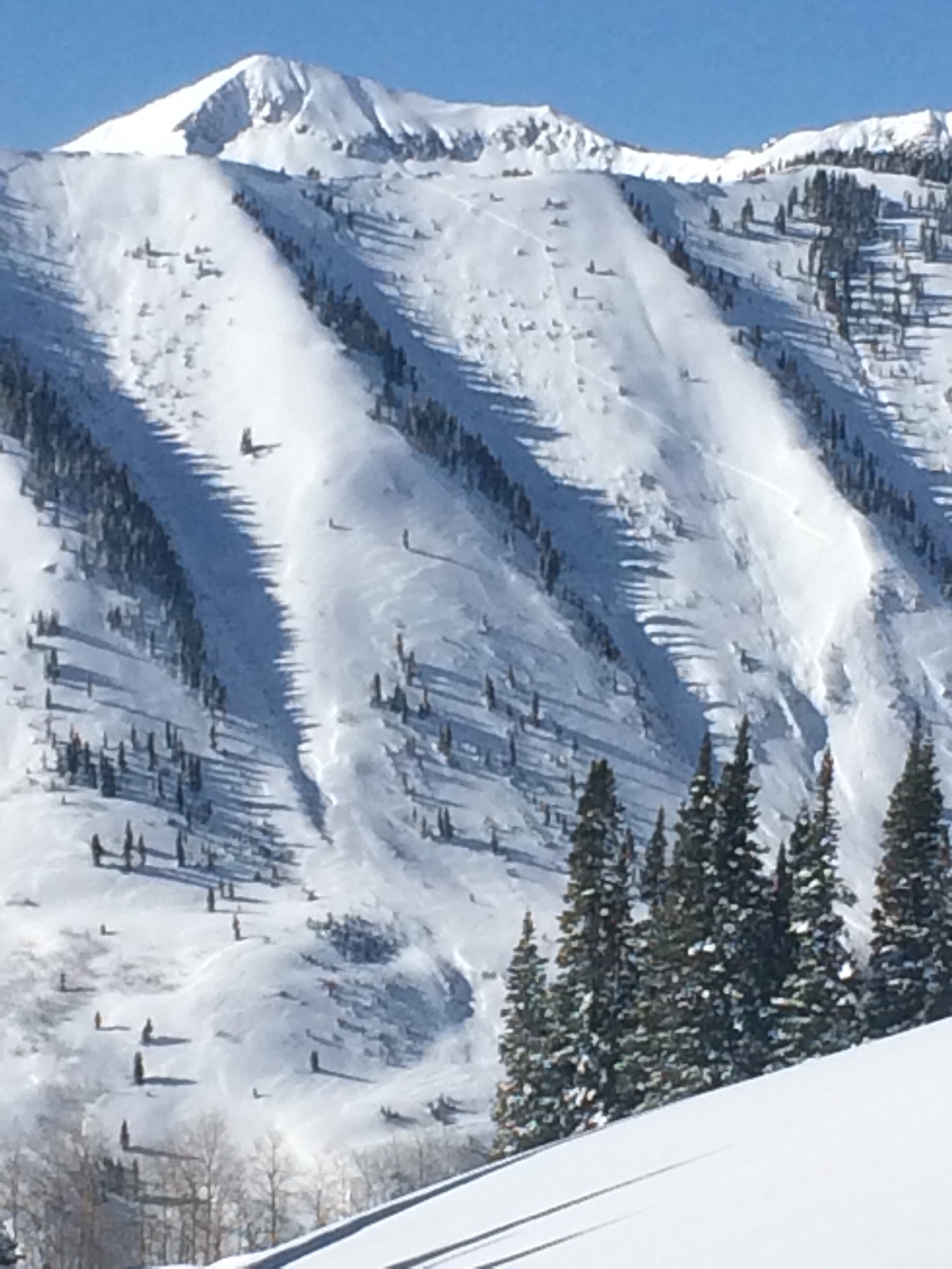
One natural D2.5 persistent slab ran during the storm, on a NNW aspect ATL. Crown looked about 3 to 5 feet deep and ran on or near the ground. HS-N-R3-D2.5-O/G
Weather: 12/25. S2 most of the day. Moderate NW winds with extreme gusts and intense snow transport. Overcast. -12C in the a.m.
12/26. Overcast decreased to clear. S-1 in the a.m. Very cold temps. Calm to light winds, minimal transport.
Snowpack: Christmas storm total was about 12″-14″, right-side-up. Snow depth in a wind sheltered flat slope was 145 cm. Ski pen was knee deep below treeline and ankle deep or less above treeline, where snow surfaces were stiffened by the wind. Stayed below treeline on 12/25 and saw no signs of instability except the avalanches described above. On 12/26, stomped on a number of suspect windloaded ridges N/ATL and couldn’t get anything to budge. No signs of instability observed other than the avalanches described above and some minor cracking in spots.

IMG_0366

Mountain Weather 12/27/2016

CB Avalanche CenterWeather

Date: 12/27/2016

Some of the season’s coldest temperatures will greet you as you step out the door this morning after a clear and calm night is pushing double digit below zero readings in the valleys (-26º in Taylor Park), while up on Scarp Ridge (12,000ft) we’re seeing a balmy 16ºF above zero. Strong solar will bounce temperatures into the mid teens today.  Looking ahead, winds increase tomorrow, along with a chance of flurries on Wednesday as the northern jetstream dips south. We’ll see quiet weather until the weekend, when it looks like another active pattern sets up to kick in 2017.