Finally some visibility

CB Avalanche Center2016-17 Observations

Location: Crested Butte Area
Date of Observation: 01/15/2017
Name: Zach Guy
Subject: Finally some visibility
Aspect: North East, East, South East, South, South West
Elevation: 9,500 -12,400

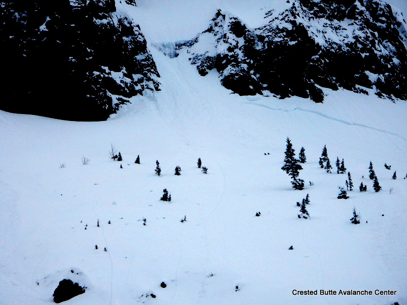
Avalanches: Good visibility looking at northerly aspects of Scarp Ridge, Schuylkill Ridge, Coneys, and E/N aspects of Ruby Range. Flat light looking northeast towards the Elk Divide. Not much for fresh avalanche crowns (See photos). Saw one D3 on a NW aspect ATL of Scarp that failed near the end of the storm, and couple of other partially filled in crowns. Subtle evidence of some very large avalanches that ran sometime during the storm off of Gothic, but the crowns are completely gone now, so can’t classify the avalanches. U-N-R4-D3-U debris piles below the Spoon (S aspect), SW gulley, and Spork (SE aspect). The one below the Spork looked to be at least 20 feet deep (D3.5?), and was a couple hundred yards or less from hitting Gothic Road. This could have been the combined pile of multiple slides. From my vantage, I didn’t see any debris piles that ran R5 or max runouts.
Weather: Thin broken clouds. Calm winds, mild temps. S-1 around sunset.
Snowpack: HS on SW aspects NTL was variable, from 240 cm to less than 100cm. The New Year’s crust was generally 150-200 cm deep, easy to ID with probe. I targeted a thin spot to dig and found advanced depth hoar below the crust, CT SC results, but didn’t propagate in 2 ECTs because talus interrupted the continuity of the layer in that spot. On SE aspects ATL, I probed into two adjacent starting zones. One had HS of 300 cm, the other had HS of 150 cm. Although the crown was no longer visible the latter had clearly run sometime during the storm (probably on mid storm layers?) and you could see debris in the flats. I dug into that slope and found about 120 cm slab over 4F 1.5mm facets, still surprisingly unsintered. On Snodgrass (E/NE aspect BTL), HS was 280 cm in start zones. Snow surfaces became moist on southerly tilts at lower elevations, and formed a thin, soft crust. Traveled on various aspects with no signs of instability except shallow but long running sluffs.

East aspect NTL on Gothic. Looks like maybe a larger crown that was filled in, because I couldn’t make out the debris.

Far running debris (D3.5?) below SE face of Gothic, came within a few hundred yards of Gothic Road.

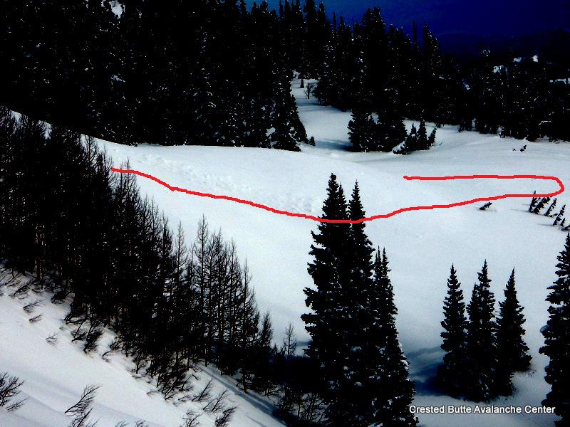
Long running debris below SW gulley of Gothic

Long running debris below mini spoon (S NTL)

Concerning structure/ suspect trigger point on SW aspect NTL.

Far running debris below Southerly aspects N/ATL

Far running debris below Spoon (S ATL).

D3. NW aspect ATL, Scarp Ridge

D2. NE aspect BTL. Washington Gulch

Down Valley

CB Avalanche Center2016-17 Observations

Location: Crested Butte Area
Date of Observation: 01/15/2017
Name: Andy
Subject: Down Valley
Aspect: North East, East
Elevation: 9,300

Avalanches: None observed from viewpoint.
Weather: Light Fog, 25 degrees. No Wind.
Snowpack: 20″-40″ Depth. Sun Crust forming from yesterday’s late sun on South faces. Very stiff HS all the way to large facets at the ground-snow interface. Lots of collapsing in the gullies and on ridges.

Goooooood

CB Avalanche Center2016-17 Observations

Location: Crested Butte Area
Date of Observation: 01/16/2017
Subject: Goooooood
Aspect: North, North East
Elevation: atl,tl,btl

Avalanches: several sluffs out of south, northeast and north aspects. Small avalanche on southwest aspect (see photo)
sluffs ran a long ways (800-1000 feet) but never entrained lower snowpack. One sluff on northeast aspect even started in steeper terrain and rolled down the gut of a gully for 800 feet still moving on a pitch that was maybe 25 degrees
Weather: overcast, zero wind even on ridge top
Snowpack: ski pen 10-14″, surface hoar forming

IMG_3319

Snodgrass/Gothic obs

CB Avalanche Center2016-17 Observations

Location: Crested Butte Area
Date of Observation: 01/14/2017
Name: Peter Innes
Subject: Snodgrass/Gothic obs
Aspect: North East, South West
Elevation: 10,000′

Avalanches: None. Some buried debris faintly visible on E apron of Gothic Mt, but have not seen any obvious crowns.
Weather: Light snow tapering to overcast w/ some brief cloud breaks causing gloppy snow
Snowpack: SW aspect BTL (10,000′), 25º, above Gothic townsite: HS 200cm, right side up, ECTN

NE aspect BTL 10,000′), 32º, on Snodgrass: HS 250cm, right side up, ECTN

No sign of buried surface hoar in either profile. Did not dig to ground but snowpack was quite uniform and showed solid structure in both cases, with about 20cm F hardness on top of 4F and 3F down to ~150cm depth (did not dig past this).

In the NE profile, aggressive shovel shear following ECTN caused slab failure 100cm down but was Q3 shear at best…this poor shear may have been due to difficulty isolating the column at that depth though.

No signs of instability in terrain traveled.

Mountain Weather 1/15/2017

CB Avalanche CenterWeather

Date: 01/15/2017

A generally quiet day of weather is on tap for the Crested Butte area today as the wandering cut-off low pressure system flirts with the Arizona/Mexico border, spinning one last ripple of moisture our direction. This moisture will bring cloud cover and an increased chance of light snow showers to our forecast area this afternoon and evening. Look for high temperatures at 11,000ft in the 32º range and light winds out of an unusual east-southeasterly direction at ridgetop. The week ahead looks dry and sunny, with our next chance of snow and another stormy period arriving Thursday through next weekend.

Granite Creek and Round Mountain

CB Avalanche Center2016-17 Observations

Location: Crested Butte Area
Date of Observation: 01/14/2017
Name: Ian Havlick
Subject: Granite Creek and Round Mountain
Aspect: North, West, North West
Elevation: 9500-11800

Avalanches: lots of D1 wet loose sluffing in steep terrain, both natural and off ski turns.
observed a few partially buried crowns from earlier in week, visibility remained limited to get longer distance observation of bigger terrain.
Weather: S2 snow tapered by 1130am, then overcast and fog, eventually clearing up to broken skies 1430. Winds were light to calm. temperatures increased from mid 20s to mid 30s by 1500.
Snowpack: Generally solid and deep with HS averaging 120-150cm, increasing with elevation. Did find reactive 4mm SH and basal facets in profile 9800ft, protected meadow, where you’d expect to find surface hoar if it was gonna be there. CT12 on SH, and CT14 on basal facets.

Dug again on more northerly, near treeline meadow and found very rightside-up snowpack with density increasing with depth. Boot pen here was about 60cm. Most concerning place to trigger a slide is margins, and places made shallow by wind scouring.

Surface snow, upper 2″ that fell during morning had interesting preserved stellars that failed easily and produced surprisingly high-speed and pushy wet loose sluffing that was worth avoiding get hit by on descent.

Slide27
Slide26
Slide25

Explosive triggered slab

CB Avalanche Center2016-17 Observations, Gallery

Location: Crested Butte Area
Date of Observation: 01/14/2017
Name: NA
Subject: Explosive triggered slab
Aspect: North West
Elevation: ATL

Avalanches: See photo
Weather:
Snowpack:

IMG_0492

Cement Creek Ob

CB Avalanche Center2016-17 Observations

Location: Cement Creek Area
Date of Observation: 01/14/2017
Name: ADB
Subject:
Aspect: South, South West
Elevation: BTL

Avalanches: Observed numerous loose snow slides below every rock outcrop and cliff on 1/13 on south/SE/SW slopes. Observed one W/SW slope near Deadman CG where entire slope was covered with loose snow slides.

on 1/14, started a slough on S/SW slope that ran about 500 feet.

None of these releases would injure someone. Some may partially bury you if caught on the road.
Weather: Obscured skies and calm transitioning to mostly cloudy.
Snowpack: new snow: 2.5 cm (1 inch)/24 hours and 17.5 to 22.5 cm (5 to 7 inches)/48 hours on SW aspects, two sun crusts in upper 7.5 cm of pack.

Sluffing and storm slab at Irwin

CB Avalanche Center2016-17 Observations

Location: Kebler Pass Area
Date of Observation: 01/14/2017
Name: Zach Guy
Subject: Sluffing and soft slab at Irwin
Aspect: South East, South, West
Elevation: 10,000-11,800 ft

Avalanches: Widespread, shallow sluffing (L-AS/N-R1-D1-S) on slopes steeper than ~38 degrees, all aspects. Skier triggered soft slab on west aspect NTL, ~15″ deep, failed on precip particles. (SS-AS-R1-D1.5-S)
Weather: S-1 to S1 and overcast most of the day. Calm winds. High of 34 in the afternoon, and brief solar breaks with greenhouse affect.
Snowpack: 3″ last night, 2″ today. Low density, new snow became more cohesive due to green housing in the afternoon.
Hand shots and airblasts in previously trafficked and/or mitigated terrain produced no results

SS-AS-R1-D1.5-S. W aspect NTL.

Mountain Weather

CB Avalanche CenterWeather

Date: 01/14/2017

The closed low over Baja continues to spin moisture into the Elk Mountains under tame winds. As the low shifts towards Texas, flow direction becomes increasingly less favorable, so snowfall will diminish. A weak ridge of high pressure arrives early next week: Our first break in active weather in over 2 weeks.