Triggered slides on Emmons

CB Avalanche Center2016-17 Observations

Location: Crested Butte Area
Date of Observation: 03/03/2017
Name: Steve n Mike
Subject: Triggered slides on Emmons
Aspect:
Elevation:

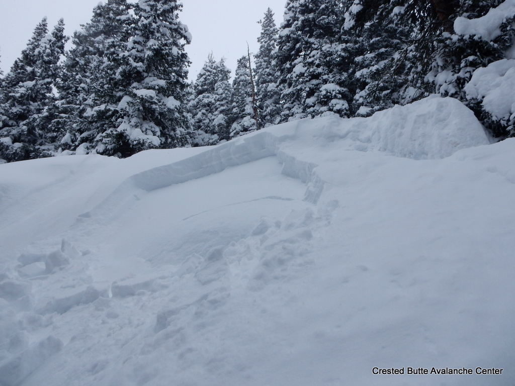
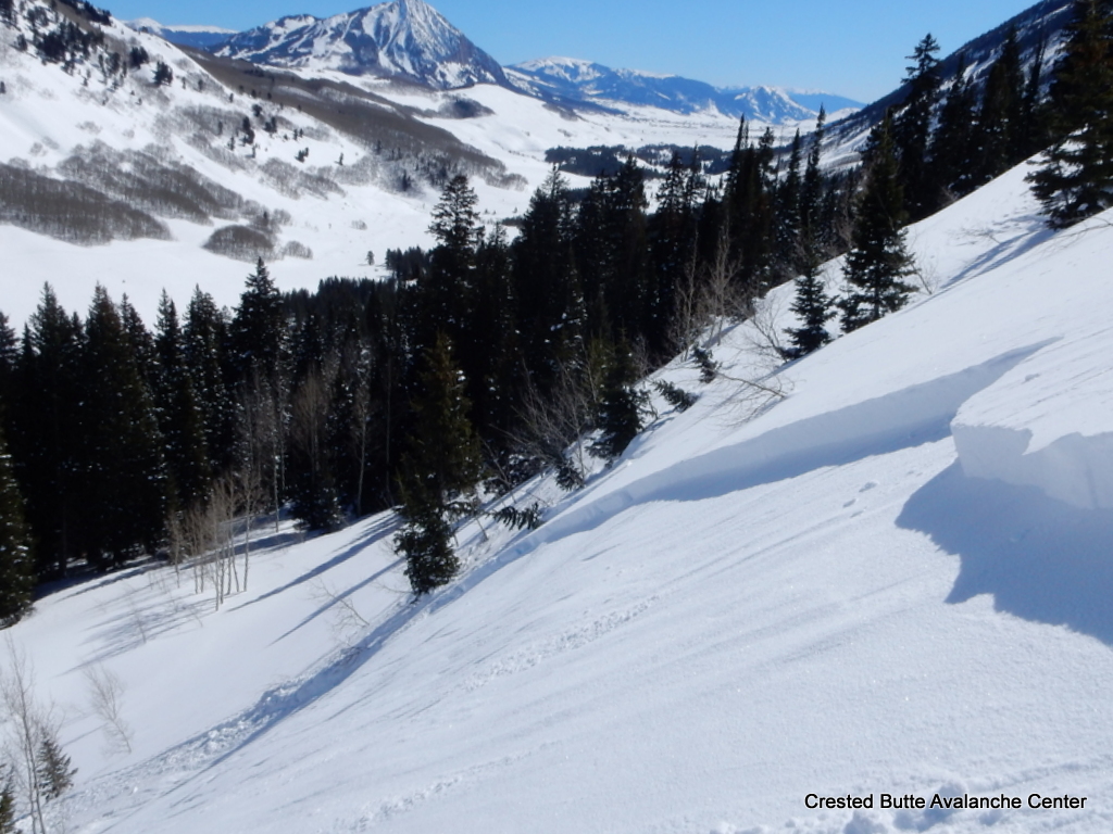
Avalanches: Triggered 2 persistent slabs today.
1 on the skiers right side of Coon Basin with a large cornice drop. D1 15m wide running about 200 vertical. Crown looked up to 30 cms deep.
SS-AC-R1-D1-O
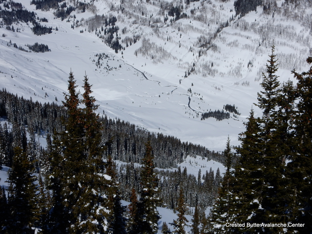
1 on a steep (38) roll on the North ridge of Emmons separating Coon and Redwell. Kind of a random spot. Heavily wind loaded, triggered on a ski cut. Surprisingly deep given the terrain. 75m wide running 200 vertical. Crown up to 70 cms deep. Pencil hard chunks of debris.
HS-ASc-R3-D1.5-O
Saw many more old crowns from Tuesday’s cycle including skiers right side of Red Lady, Pencil Chute, Wolverine, East side of Scarp Ridge, and others. From the Coon/RLB saddle there was slides to the NE and SW sides. Wind loading seemed confused and contradictory.
Weather: unny! Warm on the skin track but overall still below freezing temps. Light winds until the Alpine zone, then light ENE winds.
Snowpack: Ski Pen of 15 cms in what became hot pow on South slopes. Above treeline the snow stayed dry and was wind packed on the ridges. Zipper crust by afternoon on cooling S and SE slopes about 2 cms thick with dry snow below. Persistent slab structure obvious with the new snow (0-45 cms depending on wind transport) over buried NSF. Shady N-NE low angle slopes still holding cold snow which is faceting and even a bit slow moving.

unnamed-1
unnamed-7
unnamed-6

Coney’s

CB Avalanche Center2016-17 Observations

Location: Crested Butte Area
Date of Observation: 03/02/2017
Name: Will Nunez
Subject: Coney’s
Aspect: North East, East
Elevation: 9,000-11,000

Avalanches: Large remote triggered D1.5 on SE aspect on a steep convex roll. Other avalanches were observed up slate river N-E.
Weather: It was as clear as a bluebird day can get with temps in the low to mid 30*F Wind Calm to light on the ridgeline out of the west.
Snowpack: Touchy!! Signs of instabilities started to be noticeable at 10,500ft with large loud whumpfing and collapsing. The overnight cold temp produced small SH growth in the valley and protected areas up to 11,000ft. The new snow has started to stiffen to 4F with area of wind board ranging from 2-5” thick HS ranged for 300-250cm. Testing the snowpack to check the old snows interface for NSH resulted in CTM19Q1 30cm down on NSH East 10,000ft. Other instabilities were large checking on the downhill sides of multiple trees. See Photos

CTM19Q1
Steep-Convex-Roll-D1.5
Tree-Cracking

Remote triggers on Schuylkill Ridge

CB Avalanche Center2016-17 Observations

Location: Paradise Divide Area
Date of Observation: 03/02/2017
Name: Zach Guy
Subject: Remote triggers on Schuylkill Ridge
Aspect: North, North East, East, South East, South
Elevation: 9000’ to 11,400′

Avalanches: A group ahead of us remotely triggered 3 D1 soft slabs above a steep NE rollover below treeline, about a foot deep. Another rollover near treeline looked to be skier triggered today as well. All of these were 4F to F hard slabs over a very thin, faceted crust.
See photos of numerous previously unreported natural avalanches from around the zone that ran around 2/28. Some impressive propagation and long running slides, up to D2.5 in size.
Weather: Clear, light winds, cool temps.
Snowpack: The avalanches that failed today all held a common ingredient; enough easterly tilt to hold a very thin, faceted crust. On more northerly facing slopes lacking this crust, the buried near surface facet layer (35 cm deep) was unreactive in pits (ECTN19, BRK) and on ski cuts in steep terrain. We got several rolling collapses on low angle SE aspects NTL, but the collapses didn’t produce any avalanches in nearby start zones.

D1.5 – D2’s. Peeler Peak. NE aspect A/NTL

Several slides on Schuylkill Ridge ran to valley floor, D2.5 in size.

D2. S or SE aspect ATL, looking towards Paradise Divide.

Natural D1.5 below treeline, NE aspect of Schuylkill Ridge.

D2’s on E/NE aspects of Hancock Peak

D2, East aspect of Richmond Peak

Extensive avalanching on the west side of Schuylkill Ridge. Most paths ran with many widely propagating slides. D1.5 to D2.5, E and NE aspects.

D1.5 Climax Chutes. NE aspect NTL

D2 Purple Ridge. ENE aspect ATL.

ECTN19 on near surface facets, buried 35 cm deep. NNE aspect BTL.

Crown was up to a foot thick, failed on a very thin faceted crust.

One of 3 remotely triggered D1’s on NE aspects BTL. Triggered from above.

This appeared to be skier triggered today. NE aspect NTL, failed on a very thin, faceted crust

D2. North aspect ATL of Scarp Ridge.

D1-1.5’s in Redwell Basin, NE aspects ATL.

Axtell

CB Avalanche Center2016-17 Observations

Location: Crested Butte Area
Date of Observation: 03/02/2017
Name: Donny
Subject: Axtell
Aspect: North, West
Elevation: 9,200’ to 11,400′

Avalanches: No signs of instabilities observed.
Weather: Clear, calm and cold. Temps increased steadily throughout the day, but north aspects stayed cold and dry.
Snowpack: Heavy sluffing on the steepest terrain. Upper 20 to 30 cm was NSF over a stiffer (probably wind hardened) layer. Quick column tests produced broken blocks – nothing clean.

Mountain Weather

CB Avalanche CenterWeather

Date: 03/02/2017

The broad trough that brought our active weather earlier this week is shifting eastward across the U.S., and Colorado sits on the front end of the next feature, a broad ridge. Northwest flow will keep temperatures cool today, with a warming trend into the weekend. You’ll be burning through your sunscreen supplies until Monday.

Snodgrass

CB Avalanche Center2016-17 Observations

Location: Crested Butte Area
Date of Observation: 03/01/2017
Name: Steve Banks/ Mike Soucy
Subject: Snodgrass
Aspect: North East, East
Elevation: 9,300-11,200

Avalanches: Many fresh avalanches noted above treeline on Gothic, SE face of Mt. Belleview, both sides of Angle Pass, Wolverine, Redwell and East side of Scarp Ridge. All D2 and Easterly aspects with extensive propagation running up to 1000 vertical. Also saw crowns on Schuylkill Ridge but didn’t see the extent.
Weather: High of -8 but strong solar made it feel much warmer. Light winds with some plumes noted off the high peaks.
Snowpack: New snow settling well and stiffer due to last nights winds.
1 test profile to check the buried NSF at 10,200 NE below the Snodgrass saddle with 35 cms of new and CT 1 SC. Spooky.
Some small, localized collapses on the skin up in terrain around 30 degrees.
Thin zipper crust on S/SE slopes in the afternoon even at 11,000′.

Whetstone Slide

CB Avalanche Center2016-17 Observations

Location: Crested Butte Area
Date of Observation: 03/01/2017
Name: Brandon Clifford
Subject: Whetstone Slide
Aspect: North East
Elevation: Near treeline

Avalanches: See photo
Weather:
Snowpack:

image1-1

Naturals in Ruby Range

CB Avalanche Center2016-17 Observations

Location: Kebler Pass Area
Date of Observation: 03/01/2017
Name: Ian Havlick / Irwin Guides
Subject: Naturals in Ruby Range
Aspect:
Elevation:

Avalanches: Big slides on Marcellina, Afley, Beckwith, and Ohio Peak, several feet deep and wide propagation.
Weather: Calming winds from previous days, but still cold and blustery especially at ridgetop. Minor wind transport.
Snowpack:

Natural avalanches ATL

CB Avalanche Center2016-17 Observations

Location: Brush Creek Area
Date of Observation: 03/01/2017
Name: Zach Guy
Subject: Natural avalanches ATL
Aspect: North East, East, South East
Elevation: 9,300-12,800

Avalanches: Numerous natural D1 to D2 soft slab avalanches, mostly on easterly aspects above treeline (NE to SE). Based on crown thicknesses and snow structure obs, I assume that most of these failed on the crust/facet layers buried about 18-24″ thick. There were also a few D1 shallow wind slabs. See photos.
Weather: Cold, clear, light winds with no transport.
Snowpack: Below treeline, 12-18″ of soft slab down to the concerning persistent weak layers (crusts/facets).
Above treeline, highly variable slab thickness and distribution due to westerly winds. Most westerly aspects are scoured away. One crown profile on an ESE aspect showed 20″ of F to 4F slab over a thin melt-freeze crust with 1-2mm facets above and below. Extended column failed on isolation (ECTPV, SC).

D2 NE aspect NTL. X Chutes on Whetstone. Ran a long way.

D2 E aspect near White Rock Mountain.

D2 E aspect ATL. Near White Rock Mtn

2xD1.5 NE aspect Double Top

D1.5 NE aspect Double Top

ECTPV on 1-2mm facets below a 1 cm MFcr, 50 cm deep. ESE aspect ATL.

D2. SE aspect Hunter Hill

D1.5 SE aspect Hunter Hill

D2. NE aspect Double Top.

D1.5 E aspect Hunter Hill

D2. SE aspect Timbered Hill

D1.5/D2’s. E and NE aspects above West Brush Creek

D2. N aspect ATL. Lambertsons Peak

D1.5 East aspect ATL. Hunter Hill

D1 windslab. E aspect, Star Pass.

D2. NE aspect ATL. Carbonate Hill

Reactive persistent slabs and sluffs

CB Avalanche Center2016-17 Observations

Location: Brush Creek Area
Date of Observation: 02/28/2017
Name: Zach Guy
Subject: Reactive persistent slabs and sluffs
Aspect: East, South East
Elevation: 10600-11600

Avalanches: Skier triggered numerous loose snow avalanches in the top 12″ of the storm snow, up to D1.5 in size. Remotely triggered a small rollover from below, failed about 20″ deep on the 2/17 facet layer. SS-ASr-R1-D1-O. Poor vis, no other avalanche observations.
Weather: S-1, Overcast to broken skies, winds increased through the day, becoming strong and transporting lots of snow.
Snowpack: 18″ of storm snow at Friends Hut. The top 12″ came in very low density (~3%). Widespread loose snow instabilities, but the storm snow became slabbier through the day due to settlement and wind affect. Persistent weak layers (near surface facets and thin crust/facets) were reactive: multiple moderate collapses, a 100′ shooting crack, and remote triggered a small pocket, all on buried facets about 18-24″ deep. The most concerning structures were on ESE and E aspects, where there are thin crusts surrounded by facets.

DSCN2095-001