Issued 6:30 am, Friday, November 24th, 2017, by Ian Havlick
Despite our string of sunny days and warming weather, triggering an avalanche in isolated terrain features remains possible. Steep, high elevation, northerly facing terrain holds enough snow and poor structure to warrant caution and avoidance. The dilemma we all currently face is that the areas deep enough to skim above the rocks on skis or board, are the exact places most likely to trigger a lingering persistent slab avalanche.
Weak, sugary, faceted October snow was recently buried by our first significant storm of the year which dropped 10-20 inches of snow across our surrounding backcountry. We observed dozens of small to large natural and human triggered avalanches last week, with a very close call nearby in Aspen on November 18th. A bit of wind at higher elevations moved some of that powdery snow into stiffer windslabs in lee and cross loaded gully features, adding to the potential slab resting above that weak faceted snow just above the ground. Most recently, warm and unseasonable temperatures over Thanksgiving in the Crested Butte area has added some surface crusts to slopes facing east through south through west, with even some melt-freeze crust formation on lower elevation northerlies.
If after that quick early season summary still has you chomping to get out, get some exercise, and slide on some snow….you are braver than I. It should be business as usual out there. Everyone should have a beacon, shovel and probe. Inspect that equipment, conduct a beacon check in the parking lot (even if you start walking on dirt), and dust those cobwebs off. Once on snow, it should be easy to collect valuable snow observations with hand pits and constant probing with a pole. Look and feel for denser snow resting above weak sugary snow. That is the classic slab avalanche structure to avoid, strong over weak. Look and listen for cracking and collapsing as you travel, keeping in mind that if there are previous tracks on the slope, parties before you may have gathered valuable information like collapsing or whumphing, leading you to a false sense of stability. For each day of blue skies and mild temperatures, the likelihood of triggering an isolated persistent slab avalanche decreases, but poor snow structure demands respect, because if you are wrong, a nasty ride into rocks, stumps, and other early season hazards is likely.
For more information, scroll down and read previous conditions updates. The Crested Butte Avalanche Center will post the next conditions update on Sunday, November 26th. Full Operations and daily avalanche advisories will begin after enough snow accumulates.
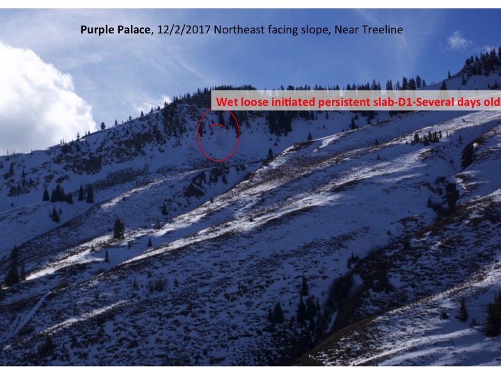
Issued 6:45 am, Wednesday, November 20, 2017, by Ben Pritchett
Persistent slab avalanches remain a possibility in steep terrain on the shady side of the compass near and above treeline. While these slabs are becoming less reactive than they were during our avalanche cycle this past weekend, they remain a serious hazard to people seeking out turns in the Ruby Range, Paradise Divide, and along the spine of the Elk Mountains. Given the thin snowpack overall, any ride in an avalanche is likely to beat you up bad. Consider the incredible luck in this recent avalanche accident just on the other side of the Elk Mountains. Here’s a picture of the avalanche, a great illustration of the kind of terrain feature where our problem lies.

Don’t underestimate the potential for a deep burial despite the paltry look of the snow cover. Here’s a recent slide, the crown, and 8 foot deep debris above Emerald Lake, near Schofield Pass.


The one additional consideration on top of our Persistent Slab avalanche problem literally lies on top of it. Tuesday afternoon we picked up several hours of west to northwest winds that drifted snow in alpine terrain on the east half of the compass. These fresh drifts accumulated several inches deep in the same features that held snow in October, hence the overlap.
Consider these fresh drifts as indicators of the Persistent Slab avalanche problem lurking below. In terms of where to travel safely and where to expect avalanches, change will be slow to come. Your safest bet is still to choose slopes on the sunny half of the compass where the most recent snow sits directly on the ground as illustrated in the first image below. If you venture into the shade, on slopes facing northwest to northeast, stick to low-angled features out of avalanche terrain.
Given that these weak layers will be slow to heal, Evan’s storm recap on Monday still rings true. I’ll leave his comments and photos below as additional detail for those venturing into the high country.
The Crested Butte Avalanche Center will post the next conditions update on Friday, November 24th. Full operations and daily avalanche advisories will begin after enough snow accumulates.
Issued 7:15 am, Monday, November 18, 2017, by Evan Ross
A large winter storm on November 17th has kicked off our winter season. This storm left the area with a Persistent Slab avalanche problem and numerous skier triggered avalanches over the weekend as seen on the Observation Page. This dangerous avalanche activity was reported from both our area and around the state. Between this avalanche problem and all the recently buried rocks, backcountry travelers need to stay heads up this week.
The November 17th storm deposited over 20” of snow at Schofield Pass in the northwest portion of our forecast area, and 9” of snow at the more centrally located Crested Butte Mountain Resort. These numbers help highlight where the mountains received enough snow to create the current Persistent Slab avalanche problem. There are two ingredients necessary for this avalanche problem: 1) More than 10” of new snow on the 17th, and 2) old buried weak layers from October. These conditions primarily line up in the Paradise Divide and Kebler Pass portions of our forecast area, at near and above treeline elevations, on slopes facing northwest to northeast. West and east facing slopes have appeared less reactive, but could still harbor the Persistent Slab issue on shaded portions of the slope. Moving to aspects further south around the compass rose, there is only the November 17th snow on the ground, thus no current avalanche problem. Ground debris just under the snow surface would be the main hazard.
This video from before the November 17th storm highlights where old weak snow is at the bottom of the snowpack. While this video on November 18th highlights the current avalanche problem and the additional hazards of a small avalanche causing traumatic injuries as it pushes you into uncovered rocks or ground hazards.
Your ideal terrain should have one layer of snow on the ground with a smooth grassy ground surface like this:

Stay away from slopes over 32 degrees in steepness with old weak snow on the ground that look like this:


 Slide4
 Slide3
 Slide2
 Slide1