Remote Triggered D2 Avalanche

CB Avalanche Center2017-18 Observations

Location: Paradise Divide Area
Date of Observation: 01/10/2018
Name: Evan Ross

Subject: Remote Triggered D2 Avalanche
Aspect: North East, East
Elevation: 9,500-10,500

Avalanches:

Remote triggered large avalanche from a lower angled (25 degrees) portion of the slope. Slope angles at the crown were in the 40-45 degree range. Crown heights of about 2.5 feet. Slab was mostly F to F+ with only about 4cm’s of 4f snow on top of the weak layer. Slab failed on 3mm depth hoar.

Weather: Headed out about 10am during a lull in the storm S-1 snow and mostly cloudy sky. Sky became obscured and snowfall started ramping up just after noon. About S2 as we left around 1:30pm.
Snowpack: Only a few inches of new snow had accumulated by the time we left at 1:30pm. Ascended an easterly aspect until 10,000ft in elevation. Soft 2cm crust just under last nights snow. Generally thick feeling snow and just barely moist down to the ground. HS around 60cm. Transitioned into northeasterly terrain above 10,000ft. HS increased to around 90cm and the soft crust under last nights snow disappeared. PS structure was still very very soft. Mostly fist plus mid-pack at best with just a little 4f snow on top of the larger basils facets. Quick snowpit at 10,200ft produced an ECTX and CT12SC on 3cm depth hoar. Only a little bit of cracking in the snow on a steep terrain feature. Didn’t feel any collapse during our short time in the terrain. Didn’t take long to remote trigger a D2 persistent slope from a lower angled snow below.

Video here: https://youtu.be/kfH3Fga8Li4

Photos:

Mountain Weather January 10, 2018

CB Avalanche CenterWeather

Date: 01/10/2018

A potent closed low-pressure system is tracking through New Mexico today, spinning moisture up towards us on a southwest flow this morning. The warm pre-fontal part of the storm will bring a small amount of dense snow this morning. Then as the storm progresses eastward a cold front will fill in behind it, putting us under our beloved westerly flow for several hours early this afternoon. We can expect nice blizzard conditions after lunch. This evening the storm will wrap up under a cold and dry northwest flow that will carry through tomorrow.

  • Today

    High Temperature: 30
    Winds/Direction: 15 to 25, gusting to 40, starting Southwest, then West, then Northwest
    Sky Cover: Overcast
    Irwin Snow: 8 to 10″
    Elkton Snow: 6 to 8″
    Friend’s Hut Snow: 4 to 6″

  • Tonight

    Low Temperature: 0
    Winds/Direction: 20 to 30, gusting to 50, Northwest
    Sky Cover: Decreasing clouds
    Irwin Snow: 0 to 2″
    Elkton Snow: 0 to 2″
    Friend’s Hut Snow: 0 to 2″

  • Tomorrow

    High Temperature: 20
    Winds/Direction: 10 to 20, gusting to 40, Northwest
    Sky Cover: Partly Cloudy
    Irwin Snow: 0
    Elkton Snow: 0
    Friend’s Hut Snow: 0

Shloppy

CB Avalanche Center2017-18 Observations

Location: Paradise Divide Area
Date of Observation: 01/09/2018
Name: Than

Subject: Shloppy
Aspect: North East
Elevation: BTL

Avalanches:

none seen

Weather: Late April
Snowpack: Mank over shite. Ski pen anywhere from 6 to 15 inches depending if you sank through the mank to the shite. raining off trees on up track. Appeared that the party before us had a collapse with cracking on a small open area near the ridge, slope angle approx. 28 degrees.

Remote Trigger

CB Avalanche Center2017-18 Observations

Location: Crested Butte Area
Date of Observation: 01/09/2018
Name: Sam lesnikoski

Subject:
Aspect: North East
Elevation: 10,000

Avalanches:

Remote triggered persistent slab, ran on basal facets. Pretty much took the whole pack with it to the ground roughly R 2 D1.5

Weather: Mostly sunny
Snowpack: Shallow and deteriorating, HS 60cm, dug a pit, results where ECT P 23 though a very inconsistent break on the basal facets/depth hoar.

Photos:

Touchy in the Anthracites

CB Avalanche Center2017-18 Observations

Location: Kebler Pass Area
Date of Observation: 01/08/2018
Name: Ben Pritchett

Subject: Touchy in the Anthracites
Aspect: North, North East, East, South East, South
Elevation: 10,000′ to 11,450′

Avalanches:

SS-ASu-R2/D1.5-O between Big Chute and Sliver. North Aspect, 10,800′.

Weather:
Snowpack: Slabs are becoming stiffer and beginning to show signs of propagating more readily than a week ago. Did several tests near and below treeline on northeast, southeast and south aspects. Found propagating results on all 3 aspects.
On the shady side of the compass, the results illustrate a present avalanche problem. We found rampant collapsing in any open terrain features, failing below the holiday slab.
On the southeast and south aspects the test results highlight problems to come as we add additional snow load. Tests failed below a nasty crust-facet combination ~50 cm down on a southeast aspect, then failed on facets above that same crust on the south aspect. With more load, expect the Persistent Slab avalanche problem distribution to expand.

Photos:

rampant cracking in any open terrain features on the shady side of the compass.

a cross section of our persistent slab avalanche problem. This snowpack is what’s collapsing and avalanching right now.

surface hoar got buried last night up to around 11,000′ in open terrain between Northwest to East aspects.

SS-ASu-R2/D1.5-O. North aspect, 10,800′, just rider’s right of Big Chute.

Mountain Weather January 9, 2018

CB Avalanche CenterWeather

Date: 01/09/2018

Where are we Whistler? We just had a 10″ powder day on Sunday, and now we’re we’re in for two more snowy days in a row. Wow, it’s great to see winter make a return.
A closed low pressure system sits in the Great Basin right now, spinning moisture our way on a Southwest flow. Today we’ll see light snow, before the storm ramps up with big winds tonight. The snowfall will get going in earnest after midnight tonight, carrying through the day tomorrow. By Thursday morning, we’ll see storm totals in the high country of around a foot, with maybe half that here in Crested Butte.

  • Today

    High Temperature: 32
    Winds/Direction: 5 to 15, gusting 30, Southwest
    Sky Cover: Overcast
    Irwin Snow: 1 to 3″
    Elkton Snow: 1 to 3″
    Friend’s Hut Snow: 1 to 3″

  • Tonight

    Low Temperature: 20
    Winds/Direction: 10 to 20, West
    Sky Cover: Overcast
    Irwin Snow: 2 to 4″
    Elkton Snow: 2 to 4″
    Friend’s Hut Snow: 1 to 3″

  • Tomorrow

    High Temperature: 25
    Winds/Direction: 20 to 30, gusting to 50 West, becoming Northwest
    Sky Cover: Overcast
    Irwin Snow: 5 to 8″
    Elkton Snow: 5 to 8″
    Friend’s Hut Snow: 4 to 6″

Coneys Observations

CB Avalanche Center2017-18 Observations

Location: Crested Butte Area
Date of Observation: 01/08/2018
Name: Thomas Ney

Subject: Coneys Observations
Aspect: North, North East, North West
Elevation: 10,500ft

Avalanches:

N/A

Weather: Thin layer of clouds in the morning leading to clear blue skys by mid-day. Temperatures in the morning were in the low teens leading to mid 30s by noon. Very calm, no wind.
Snowpack: Skinning in we noticed 3-4mm surface hoar and a woomph once we left the established skin track as we headed up lookers right side of Coneys, my partner and I headed back to the car around noon and the surface hoar was still present. We dug a quick pit on the skiers left side of Coneys on a 25 degree slope, NW aspect at 10,500ft. The snow depth was 80cm. Our ECT tests was ECTN7 Q3, Our test failed on old-new interface. (New snow 1/7/2018 and the x-mas storm interface) Our ECT also produced ECTN17 Q2 and that failed on 3cm depth hoar, which consisted of 3mm facets.

Photos:

Snodgrass Obs

CB Avalanche Center2017-18 Observations

Location: Crested Butte Area
Date of Observation: 01/08/2018
Name: Alex Tiberio

Subject: Snodgrass Obs
Aspect: North East
Elevation: 9600-10500

Avalanches:

Saw 1 slide that looks like it was skier triggered on 1/7/17 on the skiers left side of “whiskey”. Crown about 20-30 feet ran to the bottom of the first pitch, I got a couple sloughs to run short distances on my final run of the day.

Weather: Cloudy in AM clearing in afternoon
Snowpack: Surface hoar blanketed all slope I traveled on. In a few handpits earlier in the morning I could not find a defined slab. Fist hardness top to bottom. By late afternoon I saw some shooting cracks and felt one collapse.

Photos:

Mountain Weather January 8, 2018

CB Avalanche CenterWeather

Date: 01/08/2018

We have another one of those January spring days coming up as we await the next change in weather tonight. Valley low temperatures are in the single digits this morning while higher elevations are in the 20 to 30-degree range. Mountain temperatures will jump above freezing today as warm is pushed into the area on southwest flow. A Low-Pressure system is hanging out on the California coast today (poor beach people). That low-pressure system will push moisture into our area this afternoon with increasing clouds and snow starting around midnight. We should wake up tomorrow with a few inches accumulated and see snow showers continue into the mid-day. A closed low will then track south of Colorado through the mid-week keeping us in unsettled weather. Wednesday is looking best for accumulating snow but we’ll have to see where this closed low tracks. Northwest flow will finish out the week with a disturbance toward the end of the week, but looks to miss us to the north at this point.

  • Today

    High Temperature: 36
    Winds/Direction: 5 to 15/SW
    Sky Cover: Increasing clouds
    Irwin Snow: 0
    Elkton Snow: 0
    Friend’s Hut Snow: 0

  • Tonight

    Low Temperature: 28
    Winds/Direction: 5 to 15/WSW
    Sky Cover: Mostly Cloudy
    Irwin Snow: 1 to 3
    Elkton Snow: 1 to 3
    Friend’s Hut Snow: 1 to 3

  • Tomorrow

    High Temperature: 34
    Winds/Direction: 10 to 20/WSW
    Sky Cover: Mostly Cloudy
    Irwin Snow: 1 to 3
    Elkton Snow: 1 to 3
    Friend’s Hut Snow: 1 to 3

Variable Avalanche Problems And Snowpack Structure

CB Avalanche Center2017-18 Observations

Location: Paradise Divide Area
Date of Observation: 01/07/2018
Name: Evan Ross

Subject: Variable avalanche problem and snowpack structure
Aspect: North East, East
Elevation: 9,000 to 11,300

Avalanches:

Triggered a couple pockets in dense, east facing trees. D1’s as these avalanches would get dammed up by thicker trees below, but full depth 80 to 90cm avalanche crowns.

Observed a few D1 to D1.5 slabs that released during last nights storm on north to northeast facing slopes at the near treeline elevation. There were several more natural loose snow avalanches also in the D1 to D1.5 size, in similar terrain. These natural loose snow avalanches also extended into easterly aspects. Numerous skier triggered small loose snow avalanches on NE to E aspects.

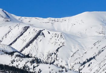
Other notable natural avalanches form last night. Augusta Mountain SSE at 12,700ft SS-N-R2-D2. Treasury Mountain, Cinnamon Mountain, SE to E ATL 5x LS-N-R1-D1 to D1.5. Peeler Peak 10,800ft NE SS-N-R1-D1.5. Also heard from other skiers of a large avalanche of the east face of Purple Mountain and skier triggered avalanches in the BTL Pittsburgh area.

Weather: Partly cloudy sky. Winds were calm, even at ridgelines. Plumes at times off the high peaks but nothing to steady that I could see.
Snowpack: Snowpack structure was quite variable between one avalanche problem to another or none at all. The most widespread problematic structure was last night’s (F) snow and the old (F) Christmas snow sitting over very weak facets. There wasn’t much for slabs, more those upper layers of very soft snow collapsing into the large grained facets below, then cracking as the whole mess just wanted to slump down hill. If you couldn’t get the slope to collapse, then slow moving loose snow avalanches were the main concern. These would entrain the whole snowpack and just slowly push there way down steep slopes.

Up-tracking in the old growth forest was the most avalanche-prone area. As the Christmas Snow still had some slab to it and aided in propagation as the snowpack collapsed again into the larger grained facets near the ground. I’ve never encountered something where the most significant avalanche problem was in the forest. Get on something over 35 degrees and it was almost certain you could get the slope to avalanche if it hadn’t avalanched previously this winter.

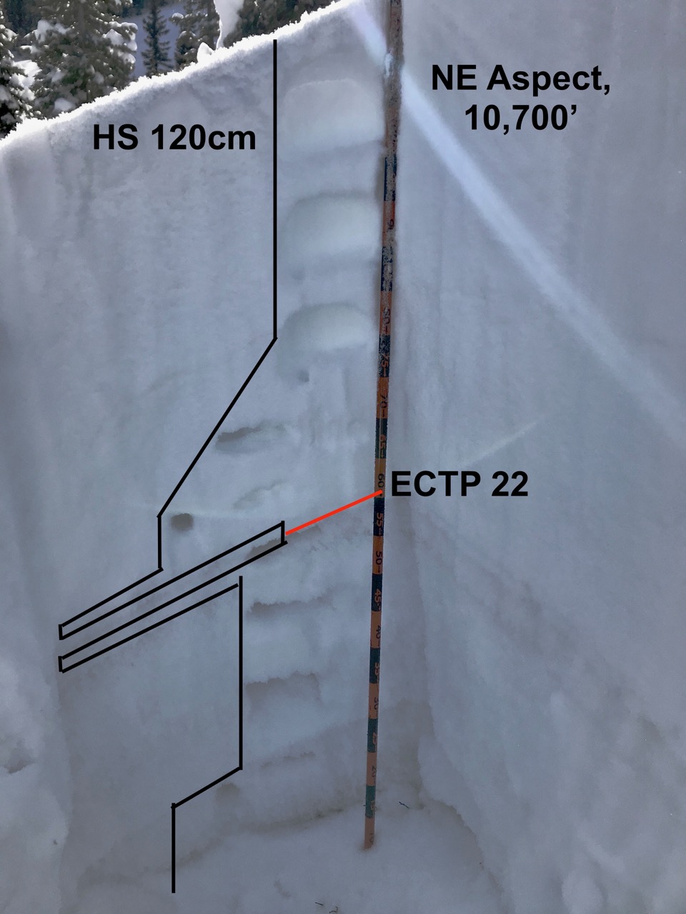
There was some recent wind-loading near ridgeline but not much. Last nights snow also had a little better slab properties near ridgeline in places. We collapsed one very large start zone that propagated and cracked 80% across the start zone or maybe 100ft. While a similar start zone, just down the ridge, was just all weak or soft snow with no slab issues.

Photos:

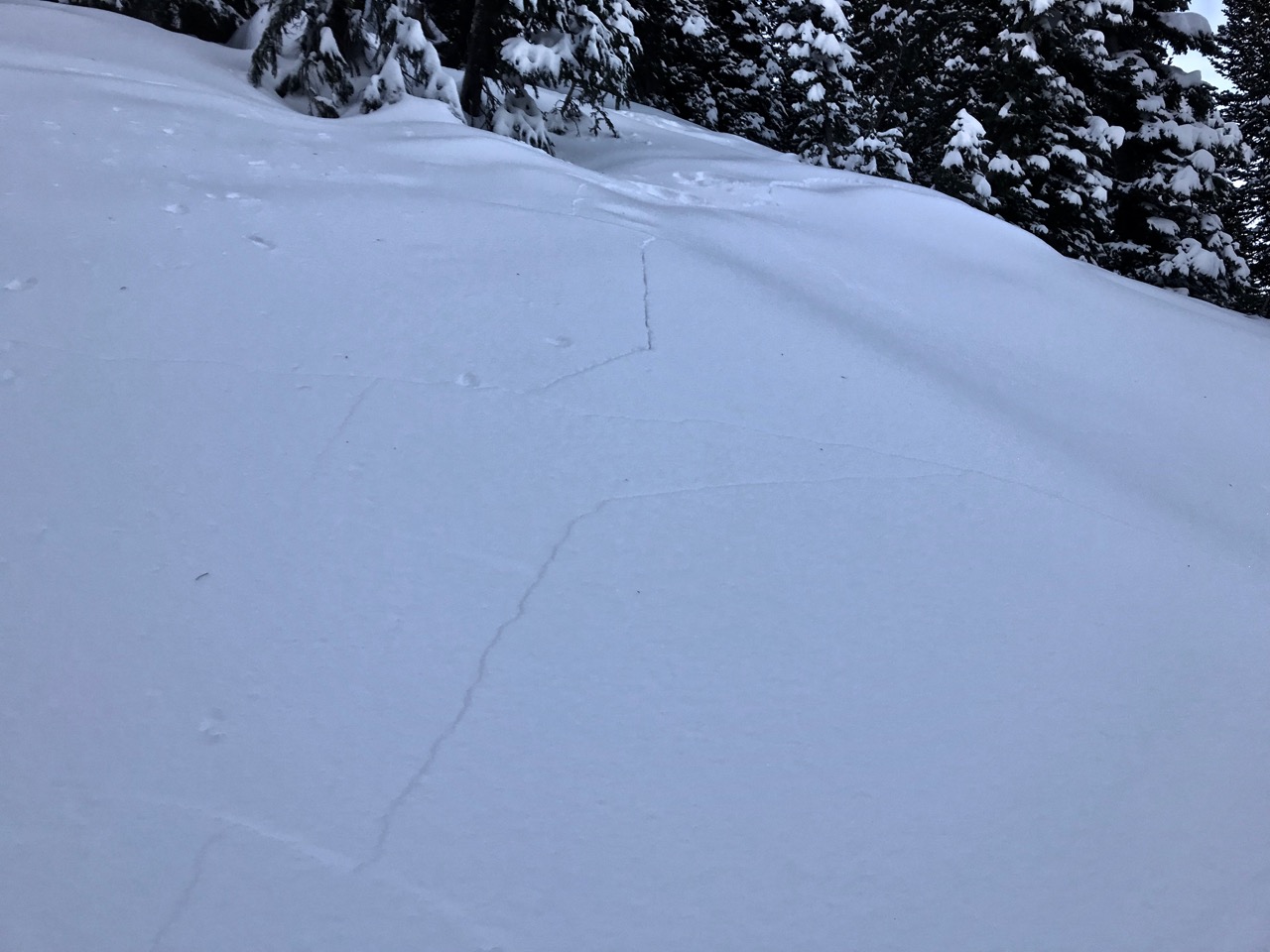
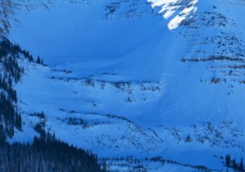
This NE start zone cracked across 80% of the start zone and back on the ridge as we neared.

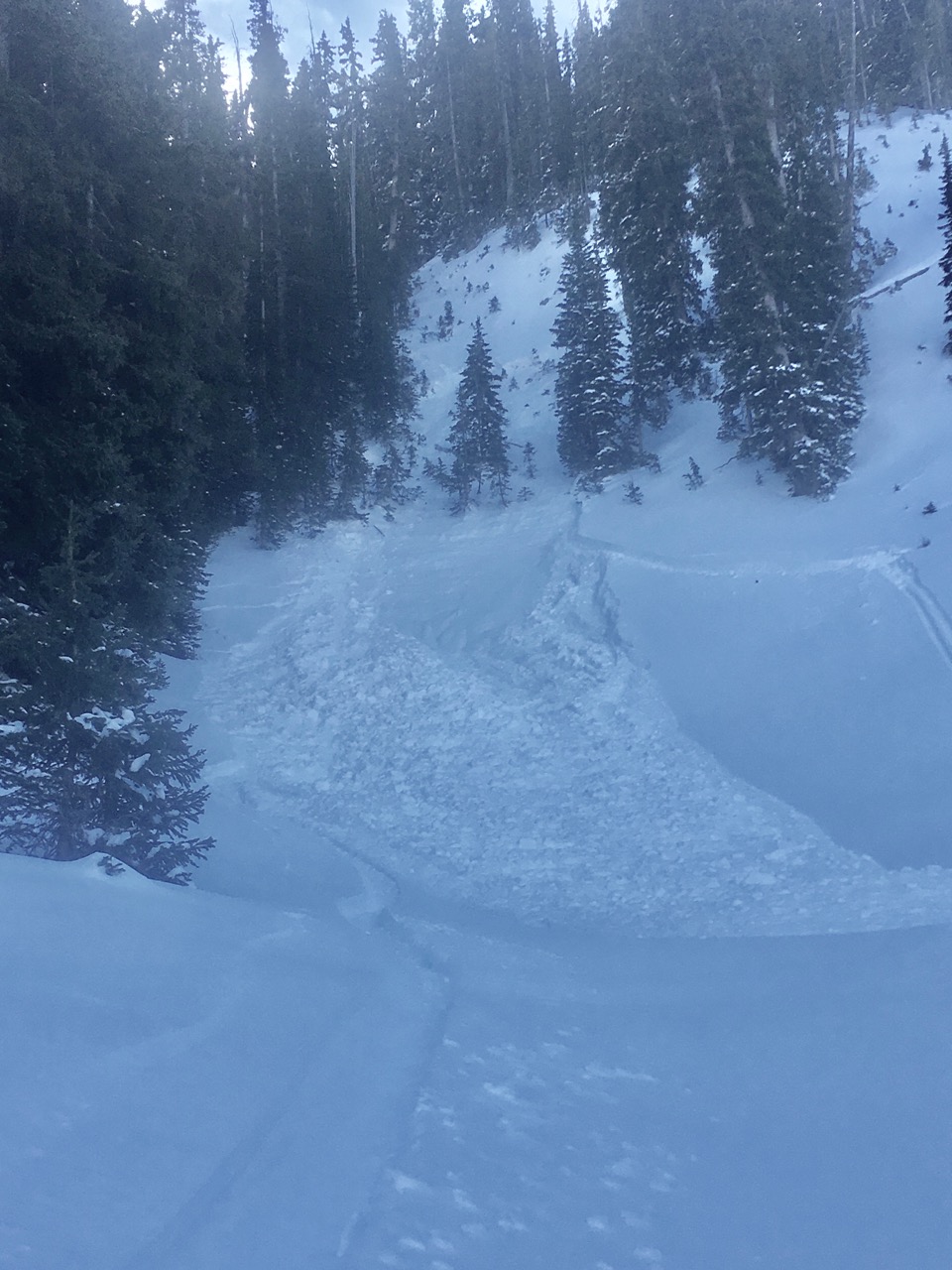
A failed kick-turn resulted in this small Loose Snow Avalanche on an easterly aspect. Numerous other skier triggered or natural loose snow avalanches in the terrain.

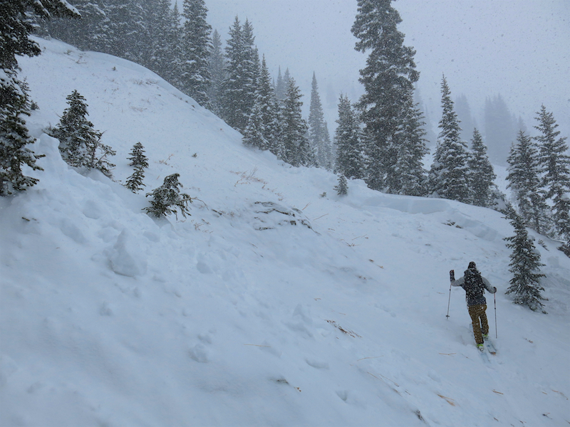
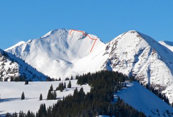
This soft PS avalanche problem was almost certain to trigger in the northeasterly facing old growth forest above 10,400ft.

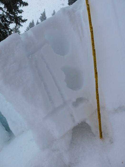
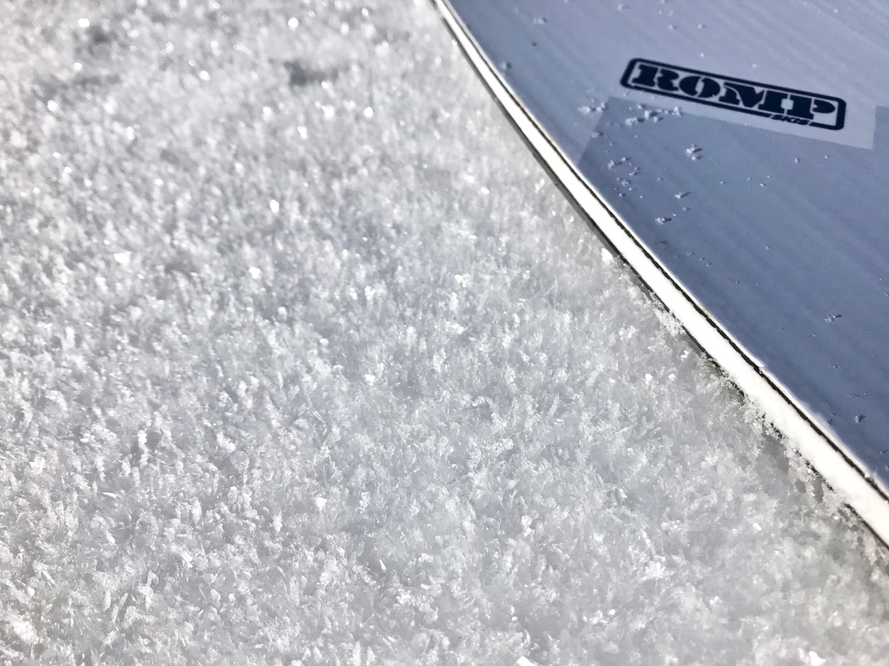
Soft snow over softer and weaker snow. HS 90cm at 11,000ft on a ENE aspect.

PEELER PEAK 10,800FT NE SS-N-R1-D1.5.

AUGUSTA MOUNTAIN SSE AT 12,700FT SS-N-R2-D2.

Treasury Mountain. 4 natural loose dry avalanches on a southeast slope, D1’s. 1 natural soft slab avalanche on a east facing slope, D1.5.