Coon Basin Slide

CB Avalanche Center2018-19 Observations

Location: Crested Butte Area
Date of Observation: 01/04/2019
Name:

Subject: Coon Basin Slide
Aspect: South East
Elevation:

Avalanches:

Coon basin slide seen from lower red lady ridge. Already reported but just another interesting angle showing the skin track that triggered the slide.

Weather: Sunny, temps around 25-30 degrees

Snowpack: Wind&sun affected layer on top of a soft layer.

Photos:

Mountain Weather for 11,000ft

CB Avalanche CenterWeather

Date: 01/06/2019

A significant system began pushing into the Crested Butte area early this morning with close to two inches at Irwin and one inch at CBMR as of 630 am. This system has impressive moisture and strong dynamics. Expect the potential for heavy snowfall from sunrise through midday today with continued snowfall tonight and tomorrow. Winds will blow at moderate speeds out of the west with enough strength to blow the new snow around.

  • Today

    High Temperature: 20 to 25
    Winds/Direction: 10 to 20, SW G30s
    Sky Cover: Overcast
    Irwin Snow: 5 to 8″
    Elkton Snow: 5 to 8″
    Friend’s Hut Snow: 3 to 6″

  • Tonight

    Low Temperature: 5 to 10
    Winds/Direction: 10 to 20, W
    Sky Cover: Mostly Cloudy
    Irwin Snow: 2 to 4″
    Elkton Snow: 2 to 4″
    Friend’s Hut Snow: 1 to 3″

  • Tomorrow

    High Temperature: 20 to 25
    Winds/Direction: 15 to 25, W
    Sky Cover: Mostly Cloudy
    Irwin Snow: 2 to 5″
    Elkton Snow: 2 to 5′
    Friend’s Hut Snow: 1 to 3″

Large slab avalanche and weak layers

CB Avalanche Center2018-19 Observations

Location: Kebler Pass Area
Date of Observation: 01/05/2019
Name: Zach Kinler

Subject: Large slab avalanche and weak layers
Aspect: North, North East, East
Elevation: 10,000′-10,600′

Avalanches:

See picture below of suspected snowmobile triggered D2 slab avalanche from this morning. The avalanche was in part of the path of a larger natural slide that occurred on 12/5. The crown appeared 3-4 ft deep from a distance and ran ~250-300ft. It broke in old snow.

Weather: Increasing clouds with high ~0C, moderate WSW winds on a quick trip up to Scarps Ridge. Light and variable winds below ridge top.

Snowpack: Punched a couple holes on an East and North aspect below tree line to test our mid December weak layers before our next loading. These Surface Hoar and Faceted Crystal layers are clearly visible while excavating the pit and produced fractures in long column tests with no propagation within the standard test. Additional loading steps and prying of the slab produced planar fractures in all tests. The overlying slabs are still very soft at F- 4F- which may be limiting propagation at this point. See pictures below with a few test results.

Surface conditions were 5 mm SH laying flat on East and 10 mm upright SH on North which look to get buried tomorrow.
Photos:

PP obs

CB Avalanche Center2018-19 Observations

Location: Paradise Divide Area
Date of Observation: 01/05/2019
Name: Joey Carpenter

Subject: PP obs
Aspect: North East, East, South East, South
Elevation: 9800-11500

Avalanches:

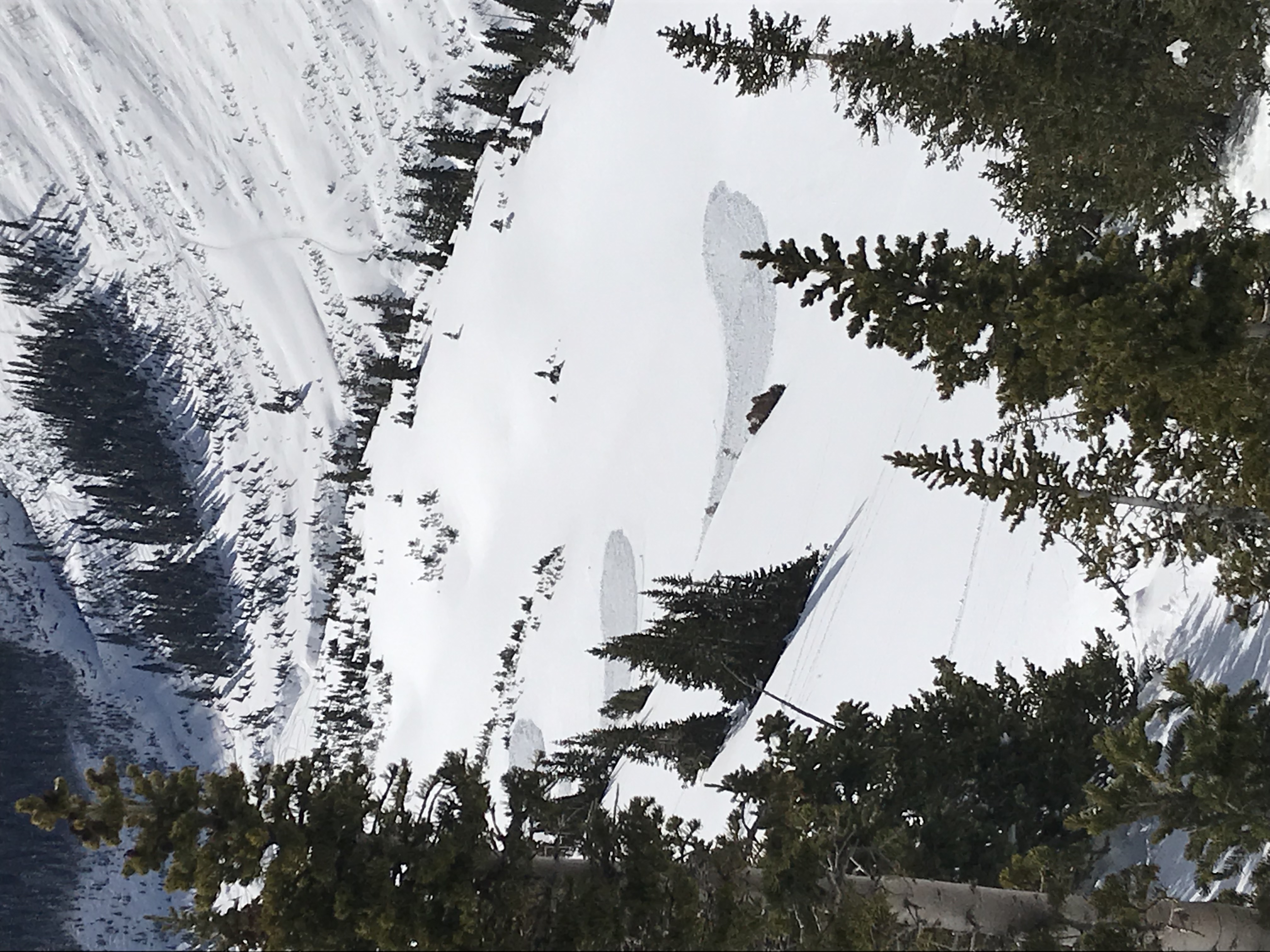
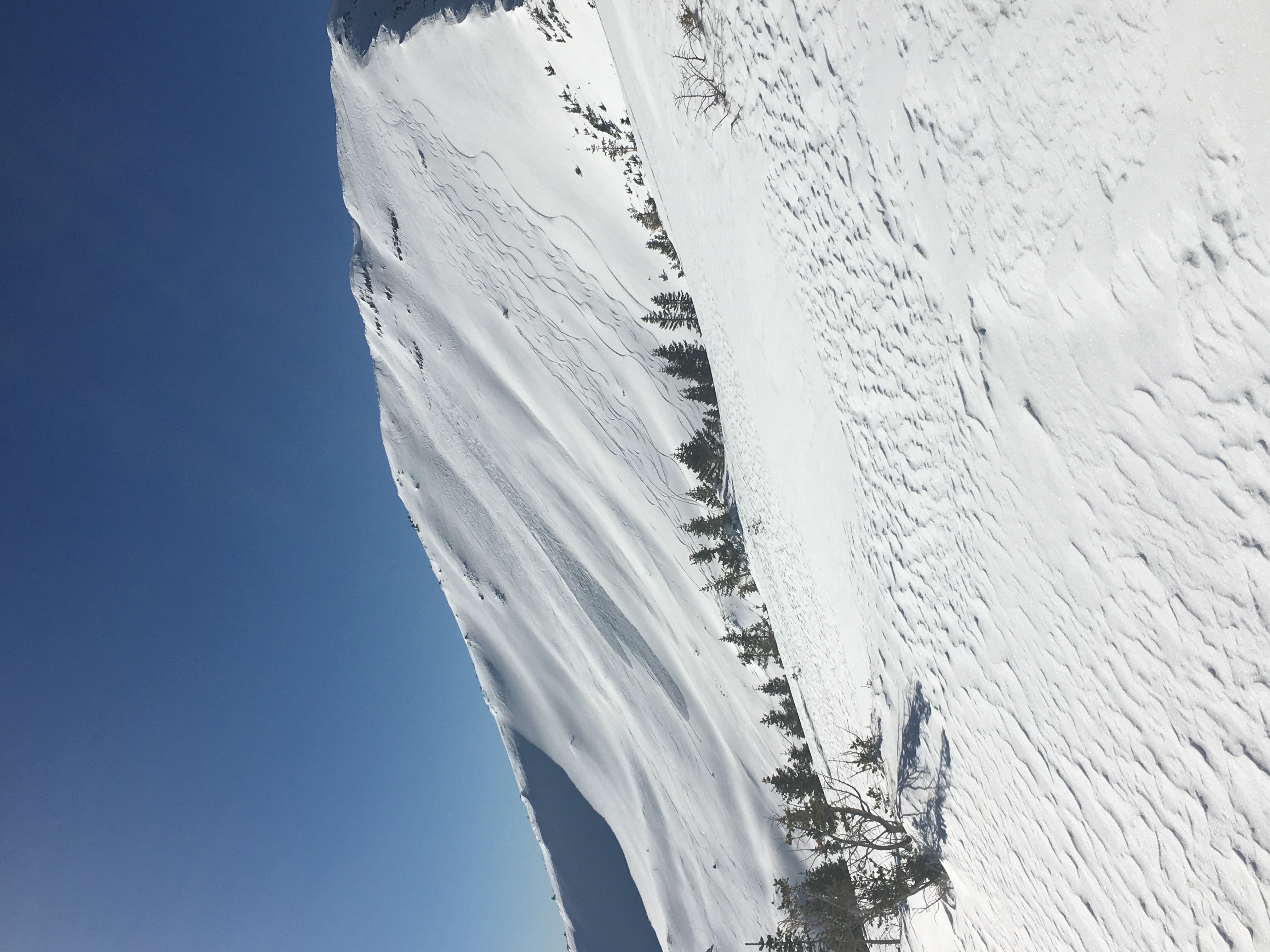
Multiple loose snow avalanches observed throughout the valley, especially on steep solar aspects. Photo of debris from 3 loose snow avalanches on steep SW facing terrain. R1D1.5. Not big enough to fully bury but certainly enough to carry.

Weather: Prior to sun making it to valley bottoms, inversion held temperatures below 0F. Rapid warming quickly brought temps into mid 30s. Low, flat clouds filtered in throughout the day. Winds went from calm to ~10mph by 2pm. No snow transport observed.

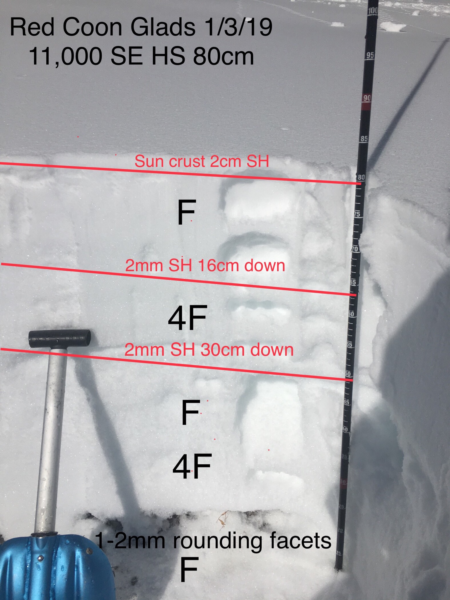
Snowpack: 2-3mm surface hoar observed between 9800-10800ft on all aspects we traveled. Intense solar radiation cooked SE, S off by midday. E, NE preserved and will presumably be buried by incoming storm. HS @ 11.5k E aspect 160cm. S, SE aspects held solid 2cm crust from yesterday even near upper elevations. During intense morning sun, the crust began to moisten and refroze as clouds moved in throughout the day.

Photos:

Mountain Weather for 11,000ft

CB Avalanche CenterWeather

Date: 01/05/2019

We will have another clear and cold start to the morning with the valleys once again diving below zero. Above the valley inversions, temperatures will again rise into the upper 30s, before high clouds begin to stream into Colorado early afternoon ahead of Sunday’s snow, and put a lid on the warm-up. Southwest winds will gradually increase throughout the day. Tonight through Monday looks like a solid snowmaker for the Elk Mountains with strong upper-level support that shifts from southwest to west orographics (wind direction) throughout the storm and could result in accumulations over 12” in the favored Kebler Pass and West Elks, as well as areas east of Crested Butte.

  • Today

    High Temperature: 35
    Winds/Direction: 15-25/SW G40s
    Sky Cover: Increasing clouds
    Irwin Snow: 0
    Elkton Snow: 0
    Friend’s Hut Snow: 0

  • Tonight

    Low Temperature: 25
    Winds/Direction: 15-25/SW
    Sky Cover: Mostly Cloudy
    Irwin Snow: 1-3″
    Elkton Snow: 1-3″
    Friend’s Hut Snow: 0-2″

  • Tomorrow

    High Temperature: 24
    Winds/Direction: 15-25/W G40s
    Sky Cover: Mostly Cloudy
    Irwin Snow: 10-14″
    Elkton Snow: 8-12″
    Friend’s Hut Snow: 8-10″

BTL Loose Dry

CB Avalanche Center2018-19 Observations

Location: Crested Butte Area
Date of Observation: 01/04/2019
Name: CBPSP

Subject: BTL Loose Dry
Aspect: North
Elevation: 10,300′

Avalanches:

Weather: Clear calm wind, with temperatures in the high 20’s.

Snowpack: Went in search of Dry loose avalanches BTL. We were able to trigger some small .5 and smaller slides in steeper terrain features that had not yet been effected by skier traffic. In isolated areas the snow we got to move would entrench the entire snow pack due to its weak nature. The HS was on avg. 60 cm very weak and faceted on N facing terrain BTL.
Photos:

Mountain Weather for 11,000ft

CB Avalanche CenterWeather

Date: 01/04/2019

Its another cold, clear and inverted morning. Valley temperatures are near or below 0, while 11,000ft temperatures are sitting in the mid 20’s. High temperatures in the mountains will creep above freezing and feel very warm with another clear sky day. Saturday will be a transition to the next storm with clouds building in the afternoon as good moisture starts to arrive on southwest flow. Fingers crossed, this is looking like a good one, with snow showers developing Saturday night and continuing through Sunday. Big money, 6-12” of snow by Monday morning. A temporarily high-pressure ridge looks to build back in for the upcoming mid-week.

  • Today

    High Temperature: 30 to 35
    Winds/Direction: 5 to 15 W
    Sky Cover: Clear
    Irwin Snow: 0
    Elkton Snow: 0
    Friend’s Hut Snow: 0

  • Tonight

    Low Temperature: 23 to 28
    Winds/Direction: 5 to 15 WSW
    Sky Cover: Clear
    Irwin Snow: 0
    Elkton Snow: 0
    Friend’s Hut Snow: 0

  • Tomorrow

    High Temperature: 30 to 35
    Winds/Direction: 5 to 15 SW
    Sky Cover: Increasing clouds
    Irwin Snow: 0
    Elkton Snow: 0
    Friend’s Hut Snow: 0

South Surface Hoar

CB Avalanche Center2018-19 Observations

Location: Kebler Pass Area
Date of Observation: 01/03/2019
Name: Will Nunez

Subject: South Surface Hoar
Aspect: South East, South
Elevation: 11,000

Avalanches:

2 small-med loose avalanches in RLB

Weather: Cold in the am, light to mod winds from the N NW, Strong solar gain in the pm. Clear all day.
Snowpack: HS ranged from 80-140Ccm
Surface Hoar is still present on all SES aspect and elevation, with strong solar it could have been melted away forming a sun crust.
Buried surface hoar still exists in the upper layers of the snow pack, reacting and planner to shovel tilt tests. SH 16cm and 30cm down, both reacting and planner. There’s still a PS structure but the basel facets are rounding and non reactive to ECTs and CTs.

Photos:

Loose Dry BTL

CB Avalanche Center2018-19 Observations

Location: Crested Butte Area
Date of Observation: 01/03/2019
Name: Alex Tiberio

Subject: Loose Dry BTL
Aspect: North
Elevation: 11,000

Avalanches:

Loose dry sluffing on every slope slope over 35 that we traveled on

Weather: Bluebird day
Snowpack: Poking around N facing shady terrain in Virginia Basin, Persistent Slab structure present in spots and nothing but weak snow in others spots. Significant surface hoar present

Photos: