Mountain Weather for 11,000ft

CB Avalanche CenterWeather

Date: 01/13/2019

For Sunday a closed low-pressure system is sitting over southern Utah and will pass by to the south of Colorado. This system will have just enough energy and moisture to keep the clouds and a few snowflakes around for another day. Accumulations will be just an inch or two at best. Winds will remain light today as they have for the past couple of days. Skies will begin to clear a bit on Monday before the next approaching snow producer that looks to arrive sometime during the middle of this week.

  • Today

    High Temperature: 19 to 24
    Winds/Direction: 2 to 12, SE
    Sky Cover: Mostly Cloudy
    Irwin Snow: 0 to 1
    Elkton Snow: 0 to 1
    Friend’s Hut Snow: 0 to 1

  • Tonight

    Low Temperature: 2 to 7
    Winds/Direction: 2 to 12, SW
    Sky Cover: Partly Cloudy
    Irwin Snow: 0
    Elkton Snow: 0
    Friend’s Hut Snow: 0

  • Tomorrow

    High Temperature: 24 to 29
    Winds/Direction: 2 to 12, W
    Sky Cover: Partly Cloudy
    Irwin Snow: o
    Elkton Snow: o
    Friend’s Hut Snow: o

Paradise Divide

CB Avalanche Center2018-19 Observations

Location: Paradise Divide Area
Date of Observation: 01/12/2019
Name: Joey Carpenter

Subject:
Aspect: North, North East, East
Elevation: 9300-10400

Avalanches:

No fresh avalanches. One near Pittsburg on NW aspect crown at 9800ft. 3ish days old. D1.5 but ran into tree stands below. Also two photos of climax crowns and debris piles as we caught a little sun on the way out. Evan reported both of these during the storm early this week.

Weather: S-1 snowfall for a good bit of the day. Minimal accumulation. Calm winds. Overcast, a few spots of sun did peek through in the morning.

Snowpack: N aspect 10.4k HS 195cm. Quick pit showed both mid-dec SH layers that appear to be decaying. CT26SCQ1 55cm down on dec SH. Additional loading steps after the upper slab was removed didn’t produce results on deeper interfaces. Surface snow was set up and surfy. Only about 6 inches ski pen. Stuck to slopes in the low-mid 30s, no SSx of instability.
Photos:

Fast And Fun

CB Avalanche Center2018-19 Observations

Location: Paradise Divide Area
Date of Observation: 01/12/2019
Name: Evan Ross

Subject:
Aspect: North East
Elevation: 9,000-11,300

Weather: Mostly cloudy and snowing S-1 for a good bit of the day. Couple inches of new snow over the last 24hr. Clam winds.

Snowpack: No collapses or obvious signs to instability. Traveling on slopes in the upper 30 degree range at all elevations traveled. Previous ski tracks in the area where on similar slopes in the upper 30 degree range and skiing through previously wind-loaded terrain. HS was generally in the 130cm range.

Dug once at about 10,000ft. NE, 30 degree slope. HS 125. ECTN just below the 1/6 storm snow on 2mm SH. ECTP H on the 4F facets near the ground. No ECT or CT results below the holiday slab in the middle of the snowpack where many recent avalanches have been failing. The old NFS grains at this interface were 1mm and progressing towards rounds with necking forming between the grains.

Photos:

Keebler Pass area obs

CB Avalanche Center2018-19 Observations

Location: Kebler Pass Area
Date of Observation: 01/12/2019
Name: Eric Murrow

Subject: Keebler Pass area obs
Aspect: North East, East, South East, South
Elevation: 9,500 – 11,250
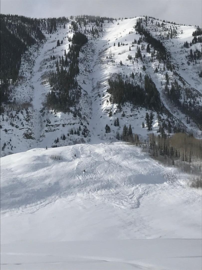
Avalanches:

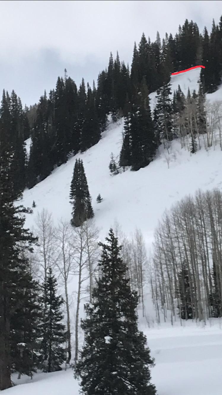
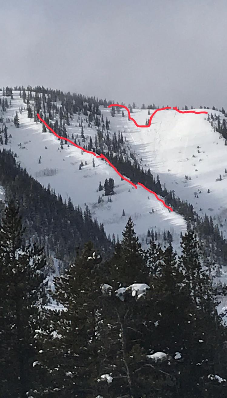
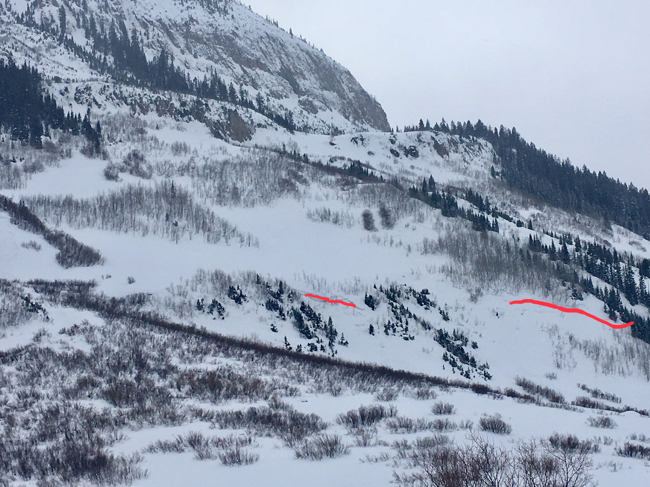
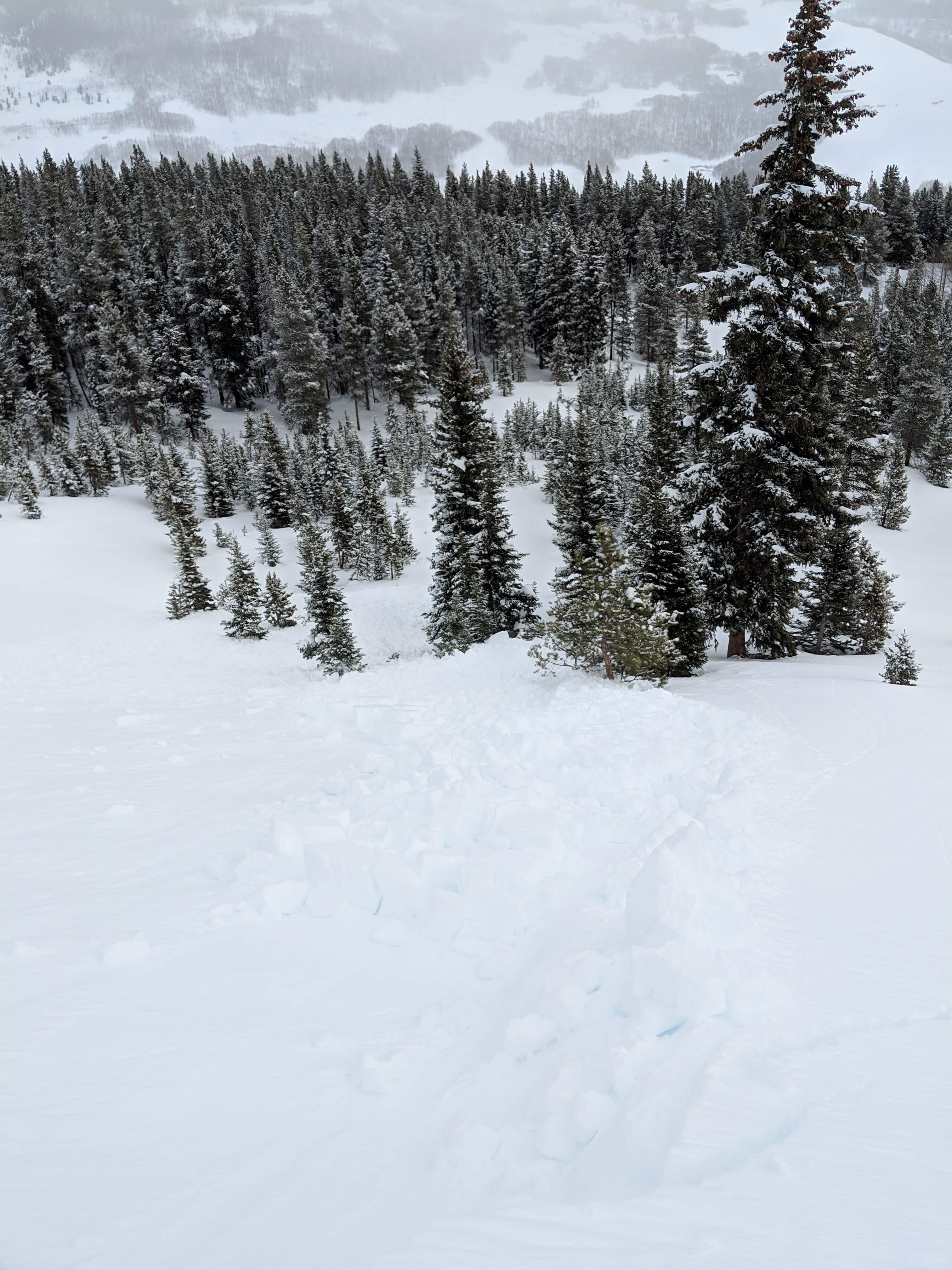
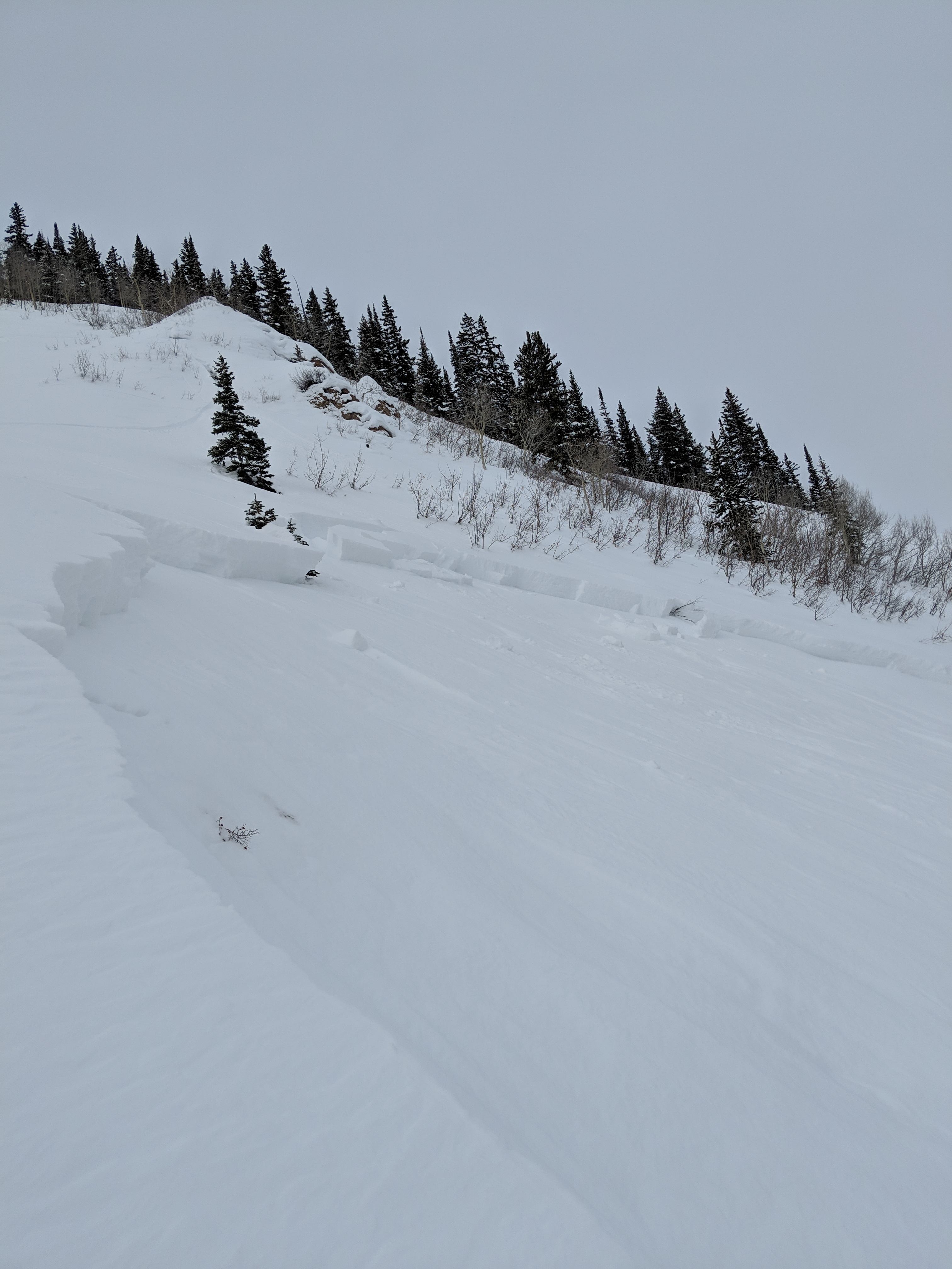
There were a few spots that looked to have avalanched early during that last storm but refilled to the point of uncertainty. These locations are very steep rollovers on ENE aspects that were likely shallow from previous avalanching earlier in the season. A few wet roller balls on SE and S aspects near treeline but entrained no mass.

Weather: Mostly overcast skies with occasional peekaboo by the sun. Mild air temps below freezing with very calm winds. Very light snow during the day with close to two inches new from past 2 days of light snow.

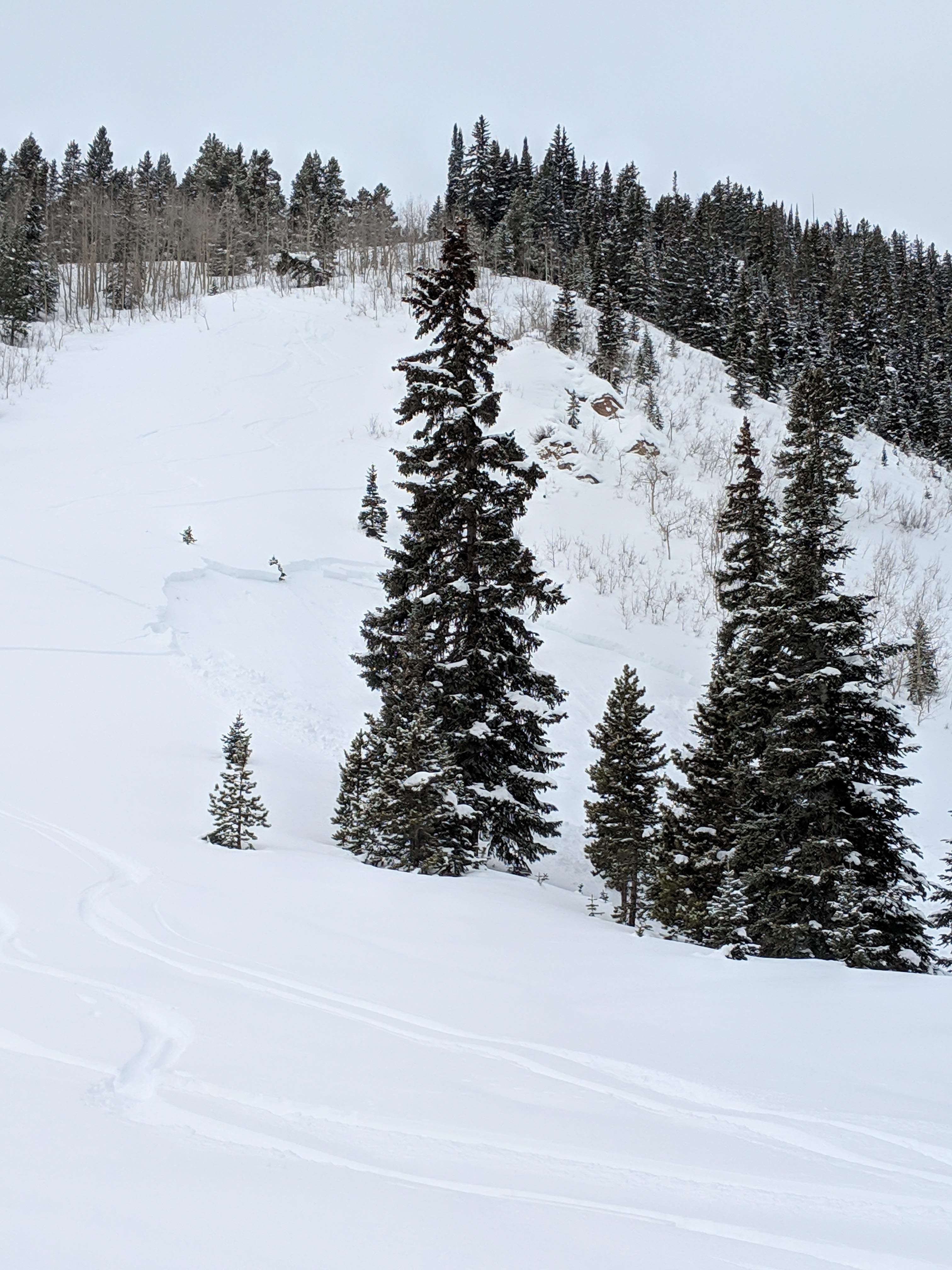
Snowpack: Travelled through a bunch of NE, E , SE and S terrain that has seen little to no traffic this winter. We stomped and jumped around on a bunch on rollovers and did not get a single collapse all day. HS on NE and E terrain ranged from around 120cm below treeline up to 150cm near treeline. SE and S slopes we crossed were around 70cm below treeline and 90cm near treeline (all locations lacked any wind loading ).
S and SE slopes below treeline consisted largely of 3 to 4 facet crusts combos with little concern with current structure (add wind drifting and you might find otherwise). Below the 2 inches of new snow was a 2cm breaker crust.
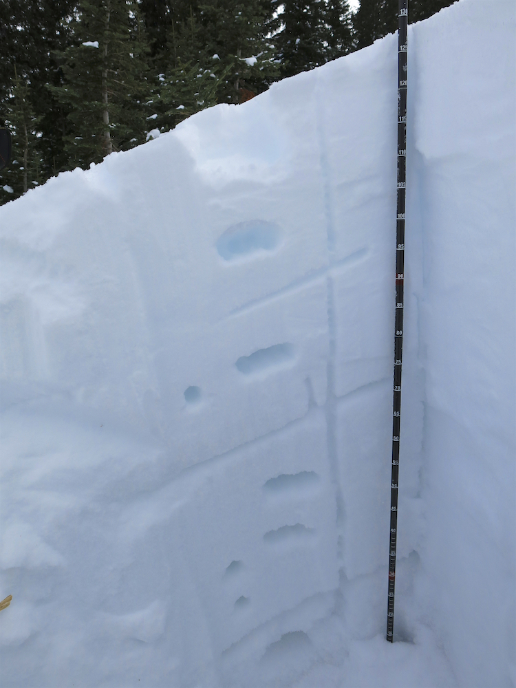
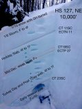
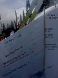
We dug a test profile on a NE slope below treeline at 10,000′ and found a snowpack structure that did not inspire confidence but did not produce concerning test results. We found weak snow at the base of the last storm, the mid-December weak layer, and basal junk. See photo below. We skied steep slope nearby with a clean run out and only produced small shallow sluffs. Snowpack was very supportive and surfy with skis on with ski pen around 6 to 8 inches.
A second profile was dug at 11,250′ on an east aspect and we found a similar structure. HS jumped up a bit to around 150cm. Same story here, slabs and weak layers, but no concerning test results, but not a confidence inspiring structure. See photo below.

Photos:

Observations from the base of Avery Peak

CB Avalanche Center2018-19 Observations

Location: Crested Butte Area
Date of Observation: 01/12/2019
Name: Irwin Guides Rec. Level 1 Avalanche Course

Subject: Observations from the base of Avery Peak
Aspect: West
Elevation: 9,600-10,000′

Avalanches:

We did not observe avalanches today, but saw several size 1-2 pockets on steep convex slopes on east through northeast aspects that probably ran early in the week. Additionally, one larger avalanche on the north side of Mt. Gothic looked to be 4-5 days old (Size 2-3). Our groups experienced several large collapses while traveling in the valley bottoms as well as on west facing slopes. No shooting cracks were observed. Our group skied short slopes up to 25 degrees.

Weather: Overcast, light snow, little to no wind. Temps in the 20’s. Skies cleared toward the end of the afternoon.

Snowpack: Hs ranged from 80-130cm. Ski pen 20 cm, Boot pen 50 cm. Snowpack structure was overall weak. Several column tests on low angle slopes displayed sudden collapse fracture characteristics with moderate loading steps 40-60 cm down. At least one buried surface hoar layer (~ 20 cm down) displayed sudden planer fractures during shovel tilt tests.
Photos:

Snodgrass Observation Tour

CB Avalanche Center2018-19 Observations

Location: Crested Butte Area
Date of Observation: 01/12/2019
Name: Avy 2 – Dave Bumgarner

Subject: Snodgrass Observation Tour
Aspect: South East
Elevation: 10,320

Avalanches:

None observed

Weather: Sky: Overcast
Precip: S-1
Wind: Calm
Temp: -5c

Snowpack: Pit:
HS: 91cm to 105cm
Incline: 26
Elevation; 10,320
Snow Surface temp: -4c
CT11SC down 16cm down, CT12SC 33cm down
ECTN11 SC 16cm down ECTP15 SC 33cm down
All fractures on buried SH layers 3-5mm in size

Throughout our tour we had multiple collapses.
We skied a 28 degree slope on the 4th shredder we had a large collapse.
Photos:

Mountain Weather for 11,000ft

CB Avalanche CenterWeather

Date: 01/12/2019

A very interesting and unusual weather scenario has been unfolding at the higher levels of the atmosphere yesterday, overnight, and continuing today. Somewhat rare northeasterly flow is drawing moisture from a strengthening “upslope” storm event on the Front Range, and bringing it back over to the western slope. Although we will not see impressive snowfall, we may sneak out a few more flakes over the course of the day. However, uncertainty is high with this rare pattern, so be prepared for surprises, especially if day time heating spurs some convective snow showers. Models do indicate our forecast area could pick up a quick 1-3” this afternoon and before moisture dissipates this evening. Temperatures should remain mild, and winds well behaved in the 5-15mph range.

  • Today

    High Temperature: 15-20
    Winds/Direction: 0-10/NE
    Sky Cover: Mostly Cloudy
    Irwin Snow: 1-3″ PM
    Elkton Snow: 1-3″ PM
    Friend’s Hut Snow: 1-3″ PM

  • Tonight

    Low Temperature: 3-5
    Winds/Direction: 5-15/SE
    Sky Cover: Decreasing clouds
    Irwin Snow: 0-1″
    Elkton Snow: 0-1″
    Friend’s Hut Snow: 0-1″

  • Tomorrow

    High Temperature: 20-25
    Winds/Direction: 5-15/WSW
    Sky Cover: Partly Cloudy
    Irwin Snow: 0
    Elkton Snow: 0
    Friend’s Hut Snow: 0

Ohio Pass Avalanche Activity

CB Avalanche Center2018-19 Observations

Location: Kebler Pass Area
Date of Observation: 01/10/2019
Name: Brian Aslum (SnoTrackers)

Subject: Ohio Pass Avalanche Activity
Aspect: East, South East, South West, West
Elevation: 9-11,000

Avalanches:

Avalanches observed post-storm across Ohio Pass road, cleared and groomed by SnoTrackers 1/10. Impressive debris. Photos show avalanche, debris, and topo map with hillshading to show slope steepness. 30º= yellows 40º=reds 45º+ = purples

Weather:

Snowpack:
Photos:

Explosive Triggered Avalanches CBMR

CB Avalanche Center2018-19 Observations

Location: Kebler Pass Area
Date of Observation: 01/11/2019
Name: CBPSP

Subject: Explosive Triggered Avalanches CBMR
Aspect: North, North East, North West
Elevation: 9-12,000

Avalanches:

Un-Opened terrain representative of backcountry snowpack.

“Flatiron R2D2 ran full track and multiple slides R2’s in highlife stepping down below T-day interface very weak snowpack on N aspects not reactive to bombs but ski cuts loose dry.”

Weather:

Snowpack:
Photos:

Snodgrass Remote Triggered Avalanche

CB Avalanche Center2018-19 Observations

Location: Crested Butte Area
Date of Observation: 01/11/2019
Name: Lawson Yow

Subject: Snodgrass Remote Triggered Avalanche
Aspect: North East, East, South East, South
Elevation: 9-11,000

Avalanches:

I was on the road then skiing E, SE slopes, so the only collapsing, cracking was when we approached that steep NE slope.

ENE slope, below treeline, a little steeper than 30°
Crown about 45 cm tall, about 20 meters across, ran the length of the slope, about 40 meters.
Remote triggered (by me, riding) from a ENE slope about 10 meters away.
Ran on NSFacets. Shallow snowpack, about 1 meter deep.

Weather:

Snowpack:
Photos: