Remote Trigger Avalanche Evans Basin

CB Avalanche Center2018-19 Observations

Location: Kebler Pass Area
Date of Observation: 02/14/2019
Name: Alex Banas

Subject: Finding some shallow love in Evan (Basin)
Aspect: East, South East
Elevation: NTL

Avalanches:

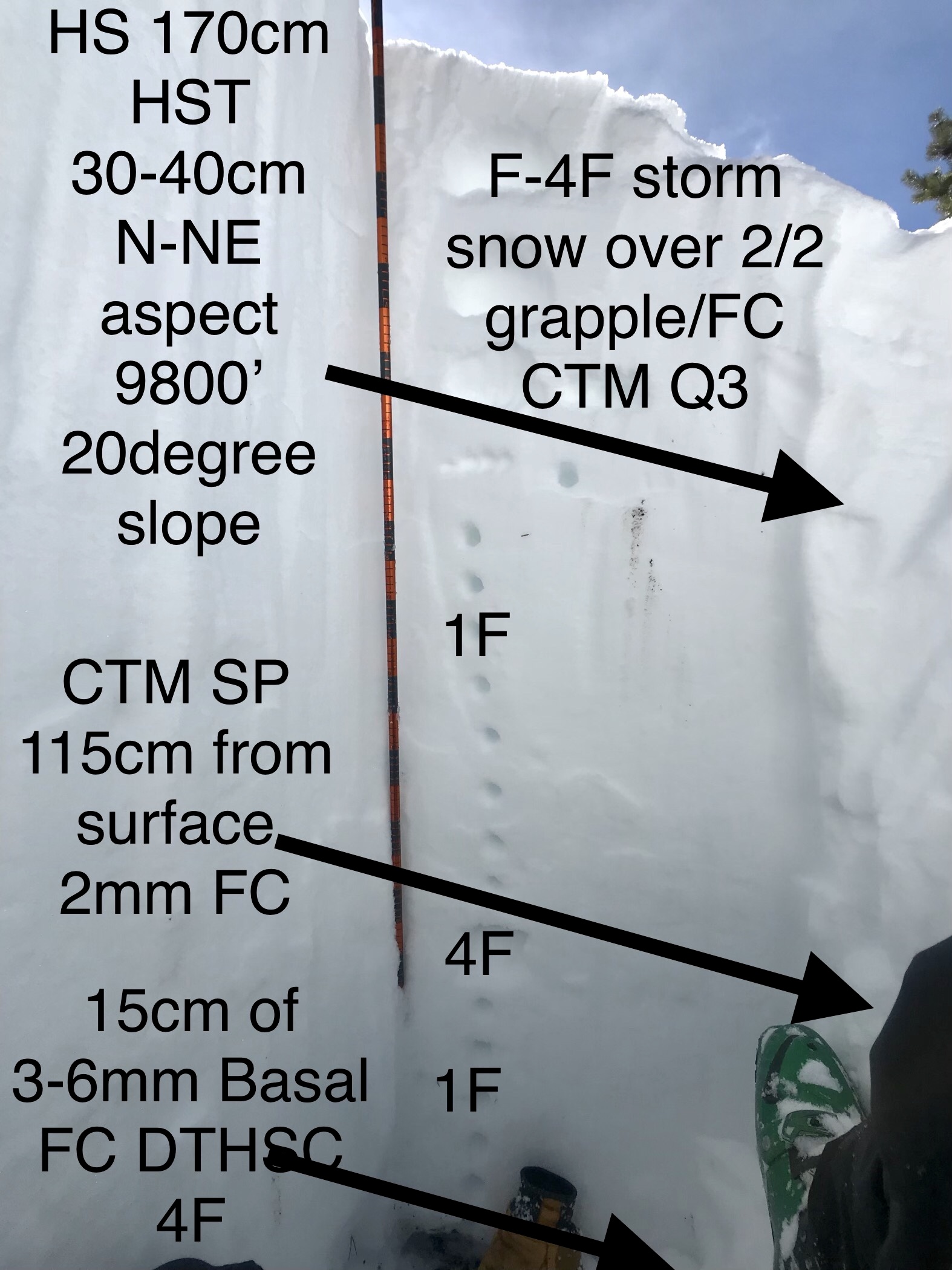
While touring up the Evans Basin ridge we remote triggered the steep, E-SE slope from 30′ away. It ran 150m wide and ran to the valley floor. Crown averaged 40cm’s deep with max depth of 65cms’s. It ran on small grained facets above a stout 2cm thick melt freeze crust. It was the 1/15 or 1/21 PWL. Midslope, it stepped down to the holiday? PWL for a 15m wide crown. SS-ASr-D2.5-O

Weather: Overcast day with calm winds and warm temps. Starting snowing S1 at 1330.

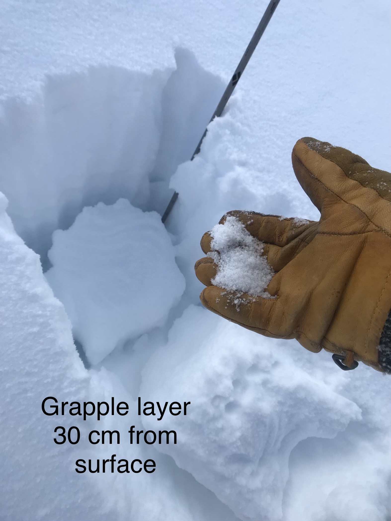
Snowpack: Today we toured up from the bottom of Elk Creek through Evans basin and over to RLG. We dug on a near treeline, east facing aspect with a hint of north in Elk Basin. HS 200cm, CT 12 SC on small grained facets down 65cm’s (1/21) The 1/15 PWL was down 80cm’s.

Photos:

Gothic Townsite 7am Obs

CB Avalanche Center2018-19 Observations

Location: Crested Butte Area
Date of Observation: 02/14/2019
Name: billy barr

Subject: Gothic Townsite 7am Obs
Aspect:
Elevation: 9000

Avalanches:

Weather: Moderate to light snow starting just before sunset before strong, steady wind starts up around 3 a.m. New snowfall is 5″ with 0.53″ water in a warm, dense, wind driven snowfall. Snowpack back up to 53½”. Overnight low of 21F and current 26F with obscured cloud cover and very light to no snow. billy

Snowpack:
Photos:

East Beckwith

CB Avalanche Center2018-19 Observations

Location: Kebler Pass Area
Date of Observation: 02/14/2019
Name: Evan Ross

Subject: East Beckwith
Aspect: North East, East
Elevation: 8,800-10,300

Avalanches:

Weather: Overcast sky and calm to light wind. No blowing snow observed and not really too much for drifting from last night in this area. Mostly S-1 through the day. Clouds where hanging on the peaks, so not much for alpine observations.

Snowpack: 4″-5″ storm totals. No change in the avalanche problem as forecasted in this generally BTL type terrain.
Photos:

Mountain Weather for 11,000ft

CB Avalanche CenterWeather

Date: 02/14/2019

The preamble is over. Time to batten down the hatches and get the bailing bucket out. Forecast snowfall and associated water numbers are impressive for the next 24 hour period, with a big plume of moisture billowing out of the Pacific. Today, showery snowfall will continue and southwesterly winds should subside slightly above treeline, before ramping up between 4-5pm. Heavy snow and strong southwest winds will continue through the night. Temperatures today will be quite balmy, highs flirting with the freezing mark, before cooling tonight into the low to mid 20s. Okay…probably should throw some numbers out. Expect 12-18″ of new snow in Kebler and Schofield Passes by tomorrow afternoon. 8-12″ closer to Crested Butte, Brush, and Cement Creek areas. Snow will continue through the weekend potentially.

  • Today

    High Temperature: 27-32
    Winds/Direction: 10-20/WSW
    Sky Cover: Mostly Cloudy
    Irwin Snow: 2-4″
    Elkton Snow: 1-3″
    Friend’s Hut Snow: 1-3″

  • Tonight

    Low Temperature: 20-25
    Winds/Direction: 10-20/SW G40s
    Sky Cover: Mostly Cloudy
    Irwin Snow: 12-18″
    Elkton Snow: 10-16″
    Friend’s Hut Snow: 8-12″

  • Tomorrow

    High Temperature: 25-30
    Winds/Direction: 10-20/W
    Sky Cover: Decreasing clouds
    Irwin Snow: 1-3″
    Elkton Snow: 1-3″
    Friend’s Hut Snow: 0-2″

Axtell 1st Bowl

CB Avalanche Center2018-19 Observations

Location: Kebler Pass Area
Date of Observation: 02/13/2019
Name: TC

Subject: Axtell 1st Bowl
Aspect: North
Elevation: 9,600-11,400

Avalanches:

No slabs, just sloughs. The far skier’s right entrance gully had sloughed through, presumably from previous skier traffic. Any undisturbed snow on the steepest portions of the slope was sloughing but not stepping down. Corner pocket had also run, but appeared to be natural and just in the new snow.

Weather: Overcast, mild temps (20s), light winds that were picking up toward the end of our tour ahead of the incoming storm system. Winds on the ridge were coming out of the SW, but down off the ridge winds were swirling, resulting in cross-loaded terrain features and some punchy wind crust in the more open terrain lower down.

Snowpack:

Photos:

Mountain Weather for 11,000ft

CB Avalanche CenterWeather

Date: 02/13/2019

Overnight cloud cover kept low temperatures much warmer than the past few nights. Starting this afternoon will begin a 3 day period of warm and wet weather for the Crested Butte area lasting through about Saturday evening. The moisture looks to come at three intervals with the potential for light snow during the in-between periods. The heaviest hits of snow will come Wednesday night, Thursday night, and Saturday. Flow directions look most favorable for the Thursday night event which is great because it will be packing the most moisture of the three snowy periods. Things are about to get exciting because a good amount of uncertainty remains about snow totals, but the moisture is impressive and flow directions are looking very favorable for the Crested Butte area.

  • Today

    High Temperature: 24 to 29
    Winds/Direction: 14 to 24, WSW
    Sky Cover: Mostly Cloudy
    Irwin Snow: 0 to 2″
    Elkton Snow: 0 to 2″
    Friend’s Hut Snow: 0 to 1″

  • Tonight

    Low Temperature: 13 to 18
    Winds/Direction: 10 to 20, G40 W
    Sky Cover: Overcast
    Irwin Snow: 4 to 7″
    Elkton Snow: 4 to 7″
    Friend’s Hut Snow: 3 to 6″

  • Tomorrow

    High Temperature: 25 to 30
    Winds/Direction: 15 to 25, W
    Sky Cover: Overcast
    Irwin Snow: 2 to 4″
    Elkton Snow: 2 to 4″
    Friend’s Hut Snow: 1 to 3″

Elk Creek Jaunt

CB Avalanche Center2018-19 Observations

Location: Kebler Pass Area
Date of Observation: 02/12/2019
Name: Zach Kinler and Eric Murrow

Subject: Elk Creek Jaunt
Aspect: North East, South
Elevation: 9600′-10,400′

Avalanches:

1x SS-ASu-R1D1-O, NE Aspect BTL (2/11)
1x SS-ASu-R2D2-O NE Aspect BTL (2/11)
1x HS-N-R1D1-I S aspect BTL(several days old)

Weather: Sunny skies and little to no wind below tree line. Temps in the mid to upper 20s.

Snowpack: Two unique snowpack structures from South-North that will certainly cause problems if our next loading event verifies. Multiple crust facet combs on South which produced propagating results in an ECT and a collapse on approach to the 25 degree slope. Slabs above and in between these interfaces range from 4F-1F. HS ~130cm.  This test profile came from just above Kebler Pass road immediately above one of the ‘7 sisters’ slide paths. See picture.

On a NE aspect with HS ~160cm we investigated a skier-triggered avalanche from yesterday. The avalanche failed on 6-8 mm SH(see picture) that was likely buried on 1/21 with a crown depth ~45cm(see picture). This was an unsupported, open slope with many large boulders, rolls and small benches with slope angles ~38-40 deg at the top and ~35 deg mid track.  A test in an uncollapsed portion of the hangfire produced an ECTP14. The slide propagated into terrain as low as 30 deg. and ran 300-400 ft over the road to the creek. Debris was up to ~1m deep.

Photos:

Slate river Valley Climax chutes NE ridge line

CB Avalanche Center2018-19 Observations

Location: Crested Butte Area
Date of Observation: 02/12/2019
Name: Chris Martin

Subject: Slate river Valley Climax chutes NE ridge line
Aspect: North, North East
Elevation: 9800′

Avalanches:

D2 – R4 observed from afar in classic climax chute repeat offender. Seems to be a natural.
Seems to have run on New snow with significant propagation across path, breaking mid slope.

Weather: Light to moderate winds as ascended out of valley flowing from W-N. Warm day, Lower 20s with light cloud coverage.

Snowpack: HS 150-170cm
HST 30-40cm
Graupel layer 30-40 cm from surface consistent from lower elevations on up to pit site at 9800′. CTM PC. Seems to be settling out. This layer is present all around the zone form 2/3 grapple event?
Reactive layer 110 from surface to small column tests CTH SP
Basal Facets Very large in size with consolidation level at 4F reacting to small column tests DTH SC.
ECTX.

Spooky layers in depths of snowpack. With these present it’ll be a while till we’re stepping on steeper north slopes. These layers

See photo.
Photos:

Mountain Weather for 11,000ft

CB Avalanche CenterWeather

Date: 02/12/2019

The snowfall from yesterday was a bit disappointing with only 1 to 3″ across the range. Skies are currently clear and will be for the first half of the day, but high clouds will build throughout the day in front of an approaching snow maker. Beginning Wednesday evening expect wet and unsettled weather to impact the area through the weekend. It is too early to start throwing out snow totals for this period, but things are looking pretty good. A significant low-pressure system is sitting out in the Pacific Ocean with a big fetch of moisture and will a bit of luck the ‘fire hose’ will point at the central mountains of Colorado. By tomorrow morning we will be able to start attaching some numbers to this impressive, moisture-rich storm.

  • Today

    High Temperature: 19 to 24
    Winds/Direction: 8 to 18, WSW
    Sky Cover: Mostly Clear
    Irwin Snow: 0
    Elkton Snow: 0
    Friend’s Hut Snow: 0

  • Tonight

    Low Temperature: 4 to 9
    Winds/Direction: 4 to 14, W
    Sky Cover: Partly Cloudy
    Irwin Snow: 0
    Elkton Snow: 0
    Friend’s Hut Snow: 0

  • Tomorrow

    High Temperature: 25 to 30
    Winds/Direction: 12 to 22, SW
    Sky Cover: Mostly Cloudy
    Irwin Snow: 0 to 2″, evening
    Elkton Snow: 0 to 2″, evening
    Friend’s Hut Snow: 0 to 2,” evening

Long Lake activity

CB Avalanche Center2018-19 Observations

Location: Crested Butte Area
Date of Observation: 02/11/2019
Name: Zach Kinler and Eric Murrow

Subject: Long Lake activity
Aspect: North East, East
Elevation: 9,000-10,200

Avalanches:

No new avalanches observed.

Weather: Blustery and cold @ 11:00 with light to moderate winds at valley floor,16F, Broken skies. After frontal passage, skies cleared and temps warmed a bit with pleasant conditions in the trees.

Snowpack: Visited a D2 avalanche that failed around the 1/16-1/18 loading event. Bed surface was filled in with ~40 cm of F hard snow. HS near crown 130cm. This avalanche failed in an open East facing slope below tree line and propagated into sparse aspens and pines. The crown was ~ 60cm deep across the slope and bed surface was a 1.5cm crust 33 cm above the ground that likely formed after a warm dry spell in mid December left a crust on top of weak snow from Nov and early Dec . Below the crust was 3 mm F-4F- Depth Hoar/Faceted Crystals.

In the shallower zones with HS below 150 cm such as this area, the snowpack has old, well developed faceted snow, 4f hard, at the ground from Thanksgiving storms and a cohesive 1f slab resting above.  Mid-January (1/15) weak layer and 2/2 interface will be players during upcoming loading event as well as basal layers if loading comes slow and steady.  Test results were ECTN on 2/2 and ECTX.

Old bed surfaces from January avalanche cycles will come to life relatively early in the next loading event.  Snow from MLK week snow and 2/2-2/7 snow that filled in this bed surface is losing cohesion and faceting – will not accept much of a load before failing again.

Photos: