


Location: Paradise Divide Area
Date of Observation: 03/01/2019
Name: Zach Kinler
Subject: Weekly Snowpack/Weather Summary
Location: Paradise Divide Area
Date of Observation: 03/01/2019
Name: Zach Kinler
Subject: Weekly Snowpack/Weather Summary
Location: Crested Butte Area
Date of Observation: 03/01/2019
Name: billy bar
Subject: Gothic 7am Report
Weather: And here we go again. Warm overnight with snow starting near sunset. Light at first but picking up around 9 p.m. and moderate during the night with strong wind after midnight. Wind lets up around 5 a.m. as snowfall picks up. Snow total is 7½” new and water content of 0.64″ as the snow pack reaches winters high of 65″. Currently obscured with heavy snow and light W wind while warm at 26F. The good news is I think it will stop by April. Maybe.
Date: 03/01/2019
Zonal westerly flow continues over the western US. Blobs of increased moisture are passing through and bringing snow showers each time. Taylor Park actually pulled off just about as much snow as Schofield Pass last night. Orographics will play a big part in where the snow stacks up the deepest, but we are seeing more widespread snowfall than I expected thanks to strong winds and the jet stream aloft. We’ll see a good pulse of snow today, with a break tonight, then the next big pulse looks to come in on Saturday. Light snow showers will linger into Monday with total storm accumulations for this whole time period looking to be in the 1 to 2 feet range. High-pressure ridge builds and brings drier weather for early next week.
High Temperature: 25 to 30
Winds/Direction: 12 to 22 G30, WSW
Sky Cover: Overcast
Irwin Snow: 5 to 7
Elkton Snow: 4 to 6
Friend’s Hut Snow: 4 to 6
Low Temperature: 18 to 22
Winds/Direction: 10 to 20, WSW
Sky Cover: Overcast
Irwin Snow: 1 to 3
Elkton Snow: 1 to 3
Friend’s Hut Snow: 1 to 3
High Temperature: 25 to 30
Winds/Direction: 10 to 20 G30, WSW
Sky Cover: Overcast
Irwin Snow: 6 to 8
Elkton Snow: 6 to 8
Friend’s Hut Snow: 6 to 8
Date: 02/28/2019
Counting flakes on the webcams this morning! The problem is, that the same flakes look to be making a couple of rounds past the webcam before they hit the ground. So, we’ll just have to wait a little longer for the Pow to come back. The lower 48 is under westerly flow. Blobs of increased moisture continue to pass by in the near forecast with some chances of snow, but nothing really exciting. There isn’t much for storm energy on Thursday or Friday so the snow that falls will largely be driven by orographics. The moisture tap starts increasing Friday afternoon and into Sunday for what looks like some game on pow. The pressure gradients across the western US starts to sag and bring in more storm energy helping increase snowfall rates for the main event Friday night into Saturday.
High Temperature: 28 to 33
Winds/Direction: 10 to 20, WSW
Sky Cover: Mostly Cloudy
Irwin Snow: 1 to 3
Elkton Snow: 1 to 3
Friend’s Hut Snow: 0 to 2
Low Temperature: 20 to 22
Winds/Direction: 10 to 20, W
Sky Cover: Mostly Cloudy
Irwin Snow: 3 to 6
Elkton Snow: 2 to 4
Friend’s Hut Snow: 1 to 3
High Temperature: 28 to 30
Winds/Direction: 12 to 22 G30, WSW
Sky Cover: Overcast
Irwin Snow: 4 to 6
Elkton Snow: 4 to 6
Friend’s Hut Snow: 2 to 4
Date: 02/27/2019
For today expect mild temperatures, increasing winds, and increasing cloud cover. A short wave disturbance is being pushed towards the area tonight by a low-pressure system in the Pacific. This first wave of moisture Wednesday night does not look to be very productive but will give a little refresh to surface conditions. On Thursday there will be a short lull in snowfall but things will ramp back up Thursday night as the next round of moisture hits the area. The upcoming weekend is looking snowy for Crested Butte. The snowfall has been incredibly consistent this winter and that trend looks to continue over the next few days.
High Temperature: 28 to 33
Winds/Direction: 12 to 22, WSW
Sky Cover: Partly Cloudy
Irwin Snow: 0″
Elkton Snow: 0″
Friend’s Hut Snow: 0″
Low Temperature: 13 to 18
Winds/Direction: 13 to 23, W
Sky Cover: Mostly Cloudy
Irwin Snow: 0 to 2″
Elkton Snow: 0 to 2″
Friend’s Hut Snow: 0 to 2″
High Temperature: 28 to 33
Winds/Direction: 8 to 18, WSW
Sky Cover: Mostly Cloudy
Irwin Snow: 2 to 4″
Elkton Snow: 2 to 4″
Friend’s Hut Snow: 2 to 4″
Location: Kebler Pass Area
Date of Observation: 02/26/2019
Name: Eric Murrow
Subject: Warm up and recent cornice fall avalanche
Aspect: North, North East, East, South East, South, South West, West, North West
Elevation:
Avalanches:
-A few very small, loose wet avalanches were visible on steep, rocky, SE terrain on Ruby (BTL and NTL) and as well as steep, rocky, S and SW slopes on Mount Crested Butte (BTL).
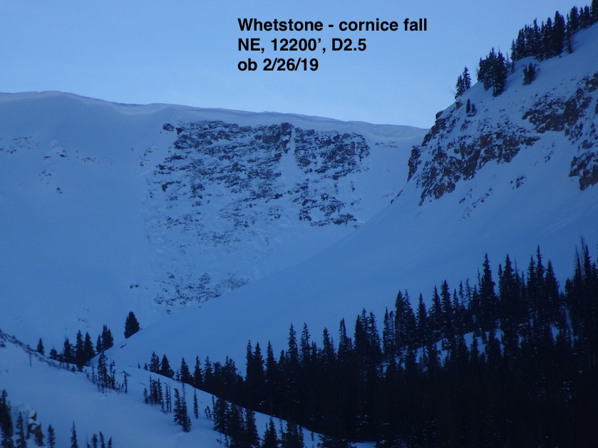
-In the AM noticed a fresh cornice fall triggered slab on Whetstone in the hidden lake basin. Sure appears as this thing ran on Monday sometime, D2.5.
Weather: Moderate air temps with light winds below treeline and lots of solar.
Snowpack: When for a quick trip up Kebler Pass in the afternoon to check on the surface conditions on sunny slopes below treeline. Below about 10,000′ SE-S-SW surfaces were wetted down about 4 to 5 inches. As you climbed above 10,000′ surface wetting only went down to about 2 to 3 inches up to about 11,000′. Close to due east had a weak breaker curst at the surface. Viewed a few snowmobile high marks in below treeline terrain on sunny slopes without results.
Photos:
Location: Paradise Divide Area
Date of Observation: 02/26/2019
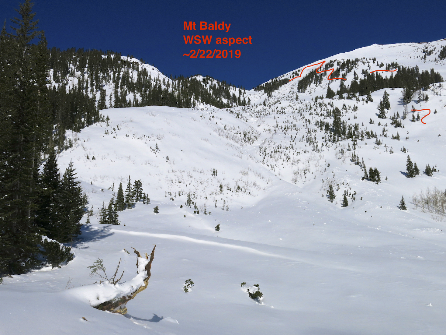
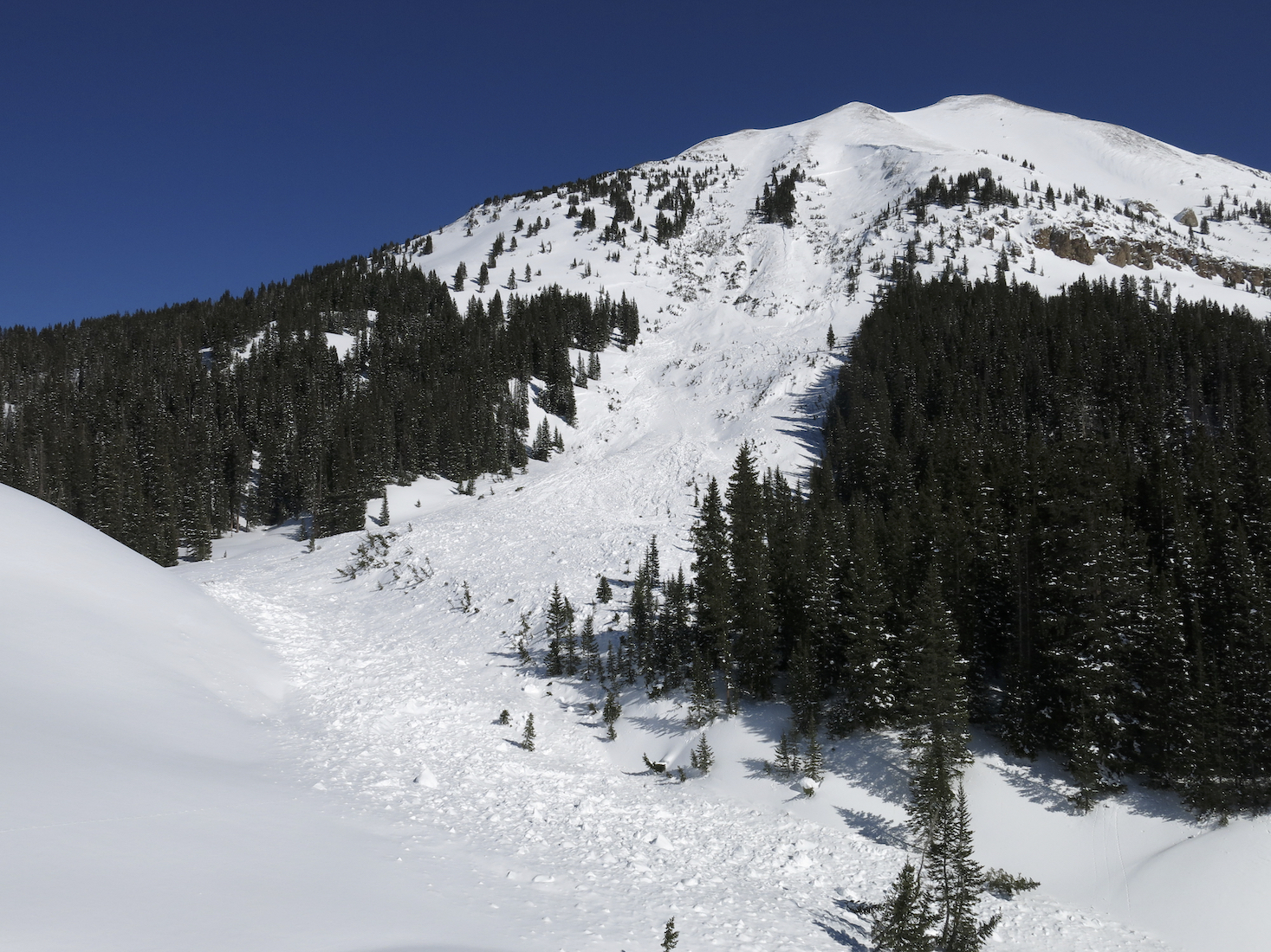
Name: Evan Ross
Subject: Eyes On A Couple Old Avalanches
Aspect: South
Avalanches:
Checked in on a couple old ones that most likely failed during the abnormal south to southeast winds last week. . See pictures below.
Snowpack: Afternoon jaunt to the Paradise Divide Area. Today’s sun and near freezing temps was warming the snow surface on southerly slopes up to ~11,500ft say. Moist snow surfaces. Some roller balls and a few small loose snow avalanches out there while looking across the range with good visibility.
Photos:
Date: 02/26/2019
Another zonal flow day is on tap with mild air temps that will raise a few degrees higher than yesterday. Winds speeds at upper elevations are currently blowing in the teens and are forecasted to be there for the day. We may see a few more clouds in the sky as well. The system in the Pacific is scheduled to begin impacting the area on Wednesday night as a hit of moisture is ejected eastward. Accumulations Wednesday night look to be a trace to an inch or so, but by Thursday night widespread moisture looks to set in with a nice refresh of surface conditions for Friday morning, maybe somewhere in the 6-inch range. Currently, models are showing wet and unsettled weather from Thursday night into early next week.
High Temperature: 27 to 32
Winds/Direction: 5 to 15, WSW
Sky Cover: Partly Cloudy
Irwin Snow: 0″
Elkton Snow: 0″
Friend’s Hut Snow: 0″
Low Temperature: 11 to 16
Winds/Direction: 5 to 15, WSW
Sky Cover: Partly Cloudy
Irwin Snow: 0″
Elkton Snow: 0″
Friend’s Hut Snow: 0″
High Temperature: 28 to 33
Winds/Direction: 8 to 18 G40, W
Sky Cover: Mostly Cloudy
Irwin Snow: 0″
Elkton Snow: 0″
Friend’s Hut Snow: 0″
Location: Kebler Pass Area
Date of Observation: 02/25/2019
Name: Eric Murrow
Subject: Kebler Pass BTL Sunnies
Aspect: East, South East, South
Elevation: 9300′ to 11000′
Avalanches:
Nothing new observed.
Weather: Mild air temps with thin clouds passing. Winds were calm below treeline, no transport observed.
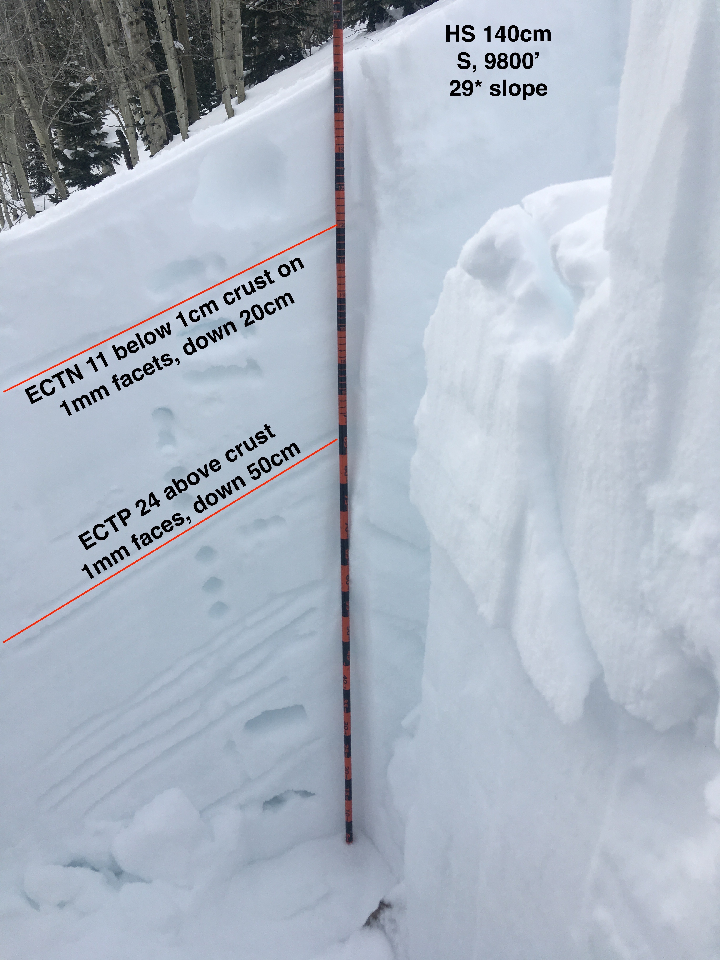
Snowpack: Poked a number of holes in S and SE slopes between 9500′ and 10,800′. HS ranged from 140cm to 175cm. All surfaces from SE-S-SW became moist today and were refreezing in the afternoon – surface crust ~1 cm thick. Two crusts of concern in the upper snowpack – the upper was generally thin ~1cm with on average 20cm F to 4f slab resting above. The lower crust was ~2.5cm thick with 40-65cm slab resting above. Facets below the second crust were up to 1.5mm in size. Upper crust produced ECTN results at all sites. Lower crust consistently produced ECTPH results below the crust, but locations with shallower HS failed above the crust.
Viewed numerous rider tracks on steep, drifted E facing features in the area and snowmobile high marks on steep, drifted SE BTL slope without any results. No collapsing while jumping on numerous small rolls.
Photos:

Date: 02/25/2019
The Crested Butte area will continue to sit under a zonal flow with the jet-stream and moisture well to our north. Today will be much like yesterday but with a few more high clouds. Expect temperatures to rise slightly as warmer air makes its way into the area. A strong inversion is currently set up with -14 at the Gunnison Airport and CBMR showing 14 at mid-mountain. A change in the weather is expected for Wednesday night and Thursday as a short wave and associated closed low will begin to impact the area and produce accumulating snowfall. This system looks to favor the central and northern mountains of Colorado with a WNW flow. We will be able to put some snow totals for this system tomorrow.
High Temperature: 26 to 31
Winds/Direction: 5 to 15, WSW
Sky Cover: Partly Cloudy
Irwin Snow: 0″
Elkton Snow: 0″
Friend’s Hut Snow: 0″
Low Temperature: 7 to 12
Winds/Direction: 4 to 14, WSW
Sky Cover: Partly Cloudy
Irwin Snow: 0″
Elkton Snow: 0″
Friend’s Hut Snow: 0″
High Temperature: 30 to 35
Winds/Direction: 12 to 22, WSW
Sky Cover: Partly Cloudy
Irwin Snow: 0″
Elkton Snow: 0″
Friend’s Hut Snow: 0″