Mountain Weather for 11,000ft

CB Avalanche CenterWeather

Date: 04/05/2019

Unsettled weather is making its way through the area today and tomorrow with little kicks of energy spurting out here and there. Increasing clouds today may produce some very light snow flurries toward the end of the day with a stronger pulse and colder temperatures coming in Saturday afternoon. Temperatures will rise above the freezing mark today and it will feel warmer with some sun and greenhouse effect. Snow totals will be minimal through the weekend and unsettled weather will continue into next week.

  • Today

    High Temperature: 30-35
    Winds/Direction: SW, 10-20 mph
    Sky Cover: Mostly Cloudy
    Irwin Snow: 0
    Elkton Snow: 0
    Friend’s Hut Snow: 0

  • Tonight

    Low Temperature: 20-25
    Winds/Direction: W, 15-20 mph
    Sky Cover: Mostly Cloudy
    Irwin Snow: 0-1″
    Elkton Snow: 0-1″
    Friend’s Hut Snow: 0-1″

  • Tomorrow

    High Temperature: 25-30
    Winds/Direction: W, 5-15 mph
    Sky Cover: Mostly Cloudy
    Irwin Snow: 1-4″
    Elkton Snow: 1-3″
    Friend’s Hut Snow: 1-3″

Wet Slab

CB Avalanche Center2018-19 Observations

Location: Cement Creek Area
Date of Observation: 04/04/2019
Name: DK

Subject: Wet Slab
Aspect: East, South East
Elevation: 9k

Avalanches:

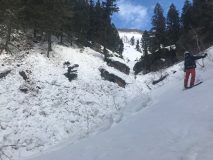
Found an older wet slab on a SE facing slope around 9k. Probably slid the same day as the ones a little further up the valley in the first narrows.

Weather: Partly cloudy this morning with enough solar on E-SE slopes to produce pinwheels in the upper 1″ of fresh snow around 9:30am.

Snowpack:

Photos:

Whetstone Axtell Carbon

CB Avalanche Center2018-19 Observations

Location: Crested Butte Area
Date of Observation: 04/04/2019
Name: Ben Ammon

Subject: Whetstone Axtell Carbon
Aspect: North, North East, East, South East, South, South West, West, North West
Elevation: 9000′-12,500′

Avalanches:

Intentionally skier triggered several wet loose slides on a S aspect of Axtell. D1, entraining only the new snow.
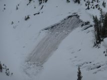
Also, saw evidence of the very large avalanches on W aspects of Whetstone and E aspects of Carbon [from March cycle]. E aspect of Carbon had snapped large aspens ~1/3 mile uphill on the opposite side of the valley. Carbon creek buried under substantial debris.
Will email pics of Carbon and Whetstone slides because they’re cool!

Weather: Broken skies moving to scattered around 1130. Light winds from the W, calm in the valleys.

Snowpack: No signs of instability on W and NW aspects of Whetstone.
New snow was wet on S, SE, E aspects of Axtell, snow beneath MF crust was still dry.
Observed two small collapses on small, isolated slopes, NE aspect of Carbon around 11,500′. These slopes were above and near areas that obviously slid during the March cycle, but were lower angle and had not slid. Skied a NE aspect on Carbon and saw no signs of windslabs on NE or E aspects ATL.

Photos:

North-Northeast Near and Below Treeline

CB Avalanche Center2018-19 Observations

Location: Kebler Pass Area
Date of Observation: 04/03/2019
Name: Steve Banks

Subject: North-Northeast Near and Below Treeline
Aspect: North, North East
Elevation: 10,500

Avalanches:

None observed

Weather: Overcast skies with heavy snowfall at times, or none at times. Light winds from the West.

Snowpack: New snow up to 4″ quickly consolidating on solar slopes with some radiation. Very supportive snowpack and still soft, good skiing on shady slopes. Southerly slopes had a 2″ crust below the new snow, though bonding seemed to be ok. Below the crust was weaker, faceted snow.
Photos:

Glide avalanche near Gothic

CB Avalanche Center2018-19 Observations

Location: Crested Butte Area
Date of Observation: 04/03/2019
Name: billy bar

Subject: Glide avalanche near Gothic
Aspect:
Elevation:

Avalanches:

Weather:

Snowpack:

Photo

Mountain Weather for 11,000ft

CB Avalanche CenterWeather

Date: 04/04/2019

Today we will see clearing skies and cool temperatures as a quick ridge of high pressure moves into the area. Some lingering snow showers are possible over the Ruby Range and Paradise Divide areas, but accumulations will be minimal and there will be more sun closer to town and to the Eastern side of the area. Clouds will again increase this afternoon and tonight ahead of another passing trough. Expect to see intermittent snow showers again on Friday and Saturday and a clearing trend as we head into next week.

  • Today

    High Temperature: 27-32
    Winds/Direction: W/SW 5-15 mph
    Sky Cover: Partly Cloudy
    Irwin Snow: 0-1″
    Elkton Snow: 0
    Friend’s Hut Snow: 0

  • Tonight

    Low Temperature: 22-27
    Winds/Direction: S-SW 5-15 mph
    Sky Cover: Mostly Cloudy
    Irwin Snow: 0-1″
    Elkton Snow: 0-1″
    Friend’s Hut Snow: 0-1″

  • Tomorrow

    High Temperature: 28-33
    Winds/Direction: SW 5-15 mph
    Sky Cover: Mostly Cloudy
    Irwin Snow: 0-2″
    Elkton Snow: 0-1″
    Friend’s Hut Snow: 0-1″

Speedy dry sloughs near treeline

CB Avalanche Center2018-19 Observations

Location: Kebler Pass Area
Date of Observation: 04/03/2019
Name: Eric Murrow

Subject: Speedy dry sloughs near treeline
Aspect: North, North East
Elevation: 9200′-12000′

Avalanches:

Observed several natural, tree bomb triggered, dry loose. Skier triggered numerous dry loose in steep, NTL terrain.

Weather: Cloudy skies with periods of snow, heavy at times. New snow accumulations at 12,000 feet, 1pm was 4 inches. Winds were lighter than expected, under 15mph while in open terrain at 12k. Visibility was limited but hung out for 30 minutes in open ATL terrain and observed almost no transport.

Snowpack: Visibility was too poor to venture into terrain with possible Wind Slab development. Skiing in steep NTL protected terrain produced fast moving shallow sloughs. Sloughs were able to entrain just a small amount of old snow at NTL elevation. Snow surface remained dry on northerly slopes down to about 10,400′ before becoming moist.

Photos:

Mountain Weather for 11,000ft

CB Avalanche CenterWeather

Date: 04/03/2019

A trough will be passing over Colorado today bringing southwest flow. Radar returns are showing a modest stream of moisture pushing into the area early this morning. Snow showers and gusty winds will be the name of the game during the day. There is the potential during the middle of the day and evening for a few stronger showers to move through dropping heavier precipitation for short periods of time. Accumulations still look modest for today, around 5 inches for locations to the west and north of town at higher elevations. Drier air moves in for Thursday and Friday, but it looks like the atmosphere will continue to have enough moisture for some cloud cover that next couple of days.

  • Today

    High Temperature: 31 to 36
    Winds/Direction: 8 to 18, W
    Sky Cover: Mostly Cloudy
    Irwin Snow: 2 to 5″
    Elkton Snow: 2 to 5″
    Friend’s Hut Snow: 2 to 4″

  • Tonight

    Low Temperature: 20 to 25
    Winds/Direction: 3 to 13, W
    Sky Cover: Mostly Cloudy
    Irwin Snow: 0 to 1″
    Elkton Snow: 0 to 1″
    Friend’s Hut Snow: 0 to 1″

  • Tomorrow

    High Temperature: 36 to 41
    Winds/Direction: 4 to 14, WSW
    Sky Cover: Mostly Cloudy
    Irwin Snow: 0
    Elkton Snow: 0
    Friend’s Hut Snow: 0