Coney’s

CB Avalanche Center2019-20 Observations

Location: Crested Butte Area
Date of Observation: 11/30/2019
Name: Eric Murrow & Zach Kinler

Subject: Coney’s
Aspect: North, North East, East
Elevation: 9600′-10,800′

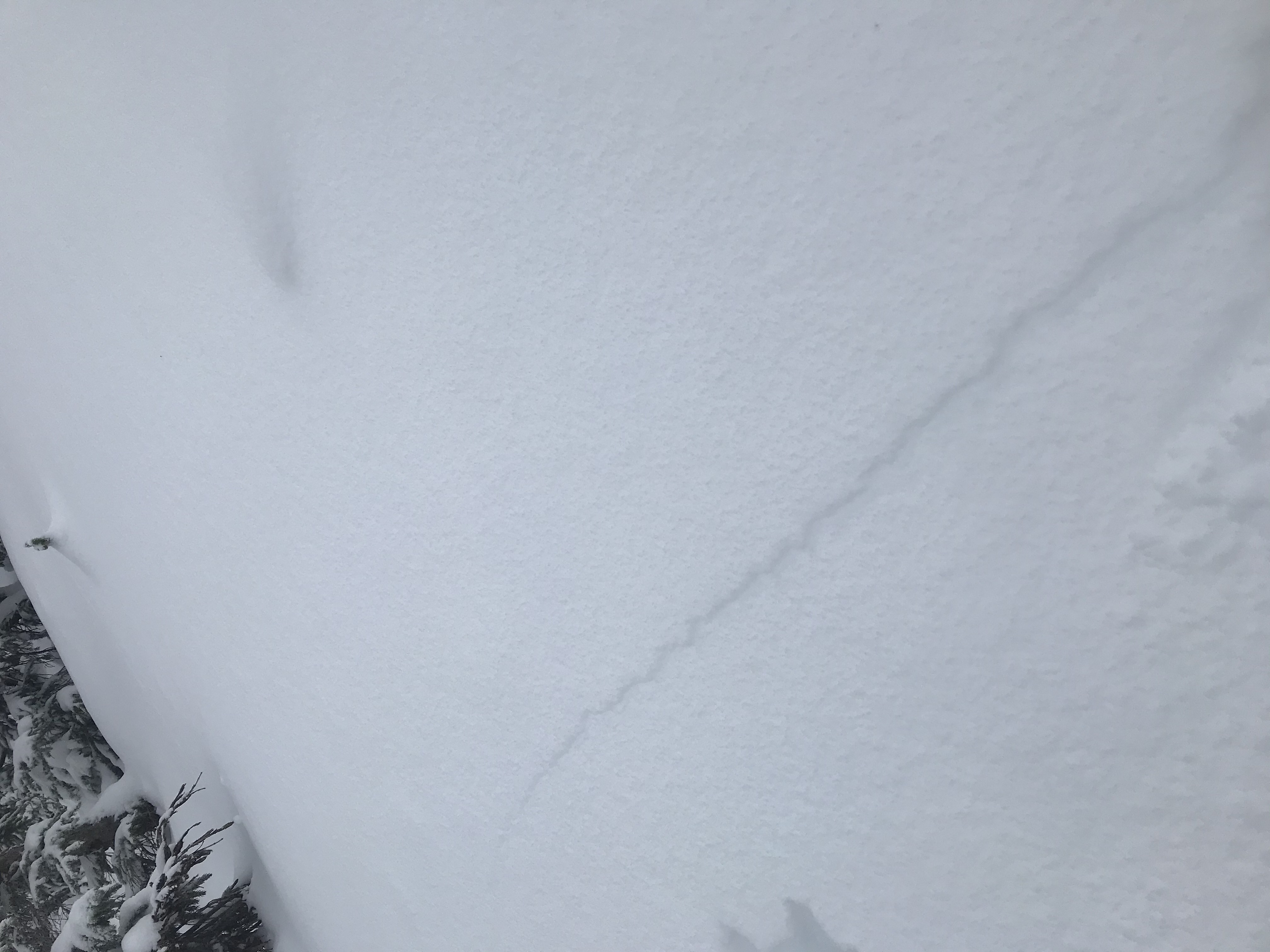
Avalanches: Two avalanches intentionally and remotely triggered from the ridgetop. D1 and D1.5. The bigger remotely triggered avalanche was not enough to bury a person but accelerated and ran about 400 vertical feet. You would have been seriously bunged up if you took this ride.

Weather: OVC, Light and variable winds in sheltered below tree line terrain, moderate WNW winds at ridgetop, intermittent S-1 with less than 1-inch accumulation. Cold with temps in the upper teens.

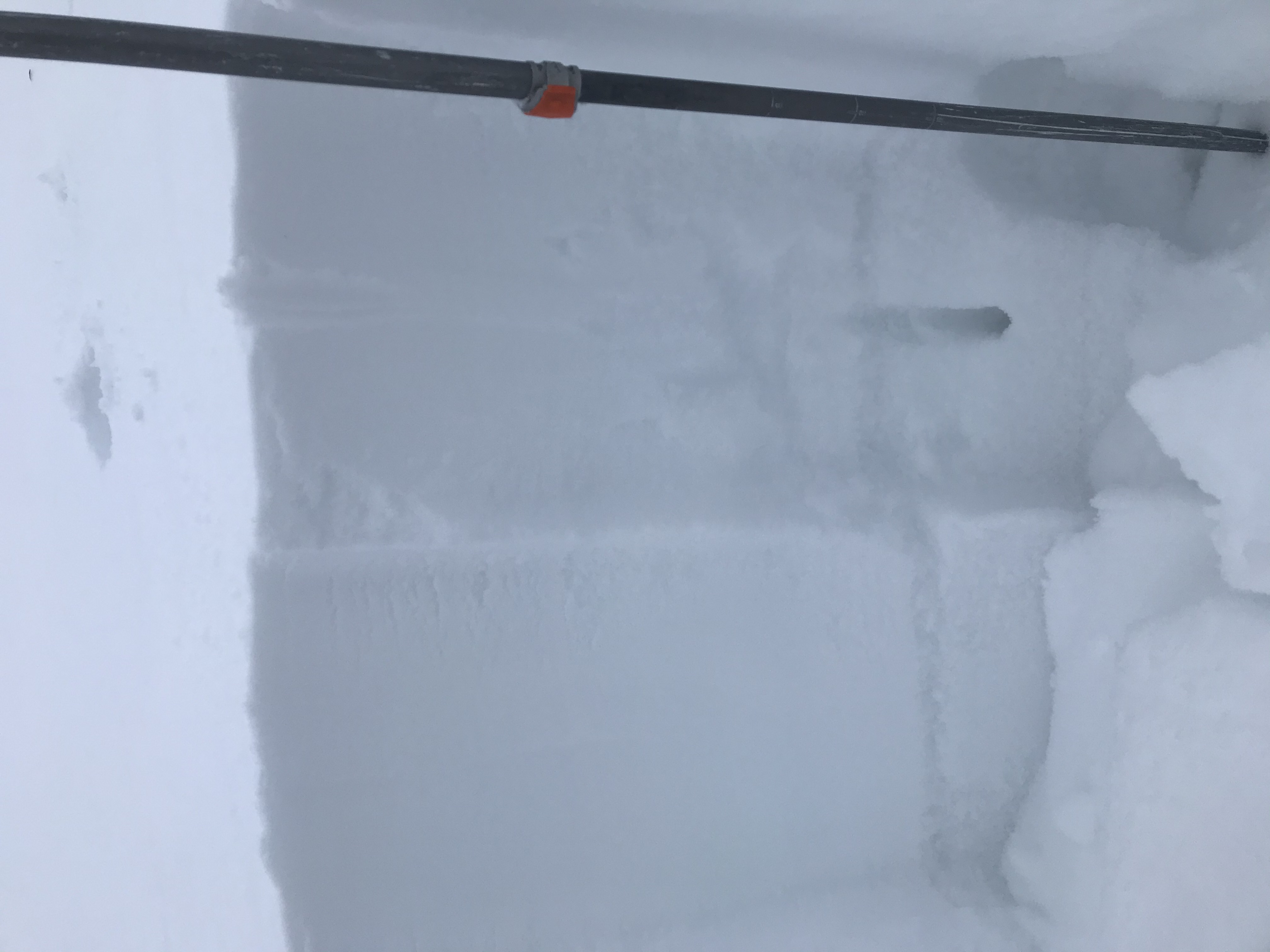
Snowpack: HS 50-60 cm in sheltered terrain. Very little old snow existed in this non-drifted low elevation terrain near the interior part of the range away from the snow belt. No cracking or collapsing observed on the sheltered skin track. Once on the ridgeline where moderate winds have drifted new snow, we immediately experienced collapses and cracking within the drifted snow. In this area immediately lee of the ridge, the October snow was much more continuous as well due to previous wind loading. Traversing the ridgetop, we were able to trigger two avalanches, D1-D1.5 in size. Once off the ridgeline and below previous and current drifting, signs of instability stopped as the weak layer was more discontinuous and thin.

Photos:

Shattery

CB Avalanche Center2019-20 Observations

Location: Crested Butte Area
Date of Observation: 11/30/2019
Name:

Subject: Shattery
Aspect: North East
Elevation: BTL

Avalanches:

none seen but no vis

Weather: Light snow off and on, moderate wind gusts.
Snowpack: Knee deep in protected N and NE slopes, 6-10 inches total on NE slopes in the open. Plenty of collapsing/cracking on skin up, protected glades in the 30-degree range N/NE shattered upon first turn but no movement.

Photos:

Gothic Townsite 5:30am Obs

CB Avalanche Center2019-20 Observations

Location: Crested Butte Area
Date of Observation: 11/30/2019
Name: billy barr

Subject: Gothic Townsite 5:30am Obs

Weather: Generally steady but light snow overnight with moderate wind as snow continues. So far 3½” overnight with 0.31″ water and for the past 22 hours there has been 7½” with 0.61″of water and snowpack is up to 12″ deep. Wind continues moderate and gusting (4-8 W gusts to 15) with light snow and temperature is 11F with the range since midnight a low of 10F and high of 12F. I will update a bit after 7 a.m. billy

Mountain Weather for 11,000ft

CB Avalanche CenterWeather

Date: 11/30/2019

Yesterday’s storm dropped between 2-16” of snow across our forecast area with the Kebler Pass area and Schofield Pass seeing over 12” (1” SWE) of accumulation, but accompanied by strong to extreme winds. Yesterday at 4pm, Scarp Ridge at 12,000ft recorded an 84 mph wind gust, and although winds have subsided slightly, gusts are still kicking into the 60mph range at 5am. As we wake up this morning, light snow will continue to diminish across our western and northern forecast area as residual moisture lifts with yesterday’s system onto the northern plains. Minimal additional snow accumulations are expected across most of our forecast area, however, the usual snow globes near Irwin and Schofield Pass may collect an additional 2-5″ today in cold, northwest flow. The temperatures above 11,000ft are hovering around zero, with frigid windchills. Looking ahead, high-pressure ridging will take hold into early next week.

  • Today

    High Temperature: 5-10
    Winds/Direction: 20-30/NW
    Sky Cover: Decreasing clouds
    Irwin Snow: 2-5″ AM
    Elkton Snow: 1-3″ AM
    Friend’s Hut Snow: 0-1″ AM

  • Tonight

    Low Temperature: -10
    Winds/Direction: 5-15/NNW
    Sky Cover: Partly Cloudy
    Irwin Snow: 0
    Elkton Snow: 0
    Friend’s Hut Snow: 0

  • Tomorrow

    High Temperature: 20-25
    Winds/Direction: 5-15/W
    Sky Cover: Mostly Clear
    Irwin Snow: 0
    Elkton Snow: 0
    Friend’s Hut Snow: 0

Gothic Townsite 7pm Obs

CB Avalanche Center2019-20 Observations

Location: Crested Butte Area
Date of Observation: 11/29/2019
Name: billy barr

Subject: Gothic Townsite 7pm Obs
Aspect:
Elevation: 9500

Avalanches:
Weather: Quiet through the morning with light snow starting mid day but strong wind. Snow picks up mid afternoon then become heavy as wind stops before snowfall stopping after an hour or so. Wind has died down and snow still on pause. New snow totaled 4″ with 0.30″ of water. Snow pack at 9″. Currently overcast but no snow with generally light wind but occasional strong gusts to 25. Days high was 34F but now dropping at 21F.

If snow starts back up I will try and update early morning, otherwise not until near 7. billy
Snowpack:

Photos:

Mountain Weather for 11,000ft

CB Avalanche CenterWeather

Date: 11/29/2019

A digging low-pressure system that has stalled longer than forecast across the desert southwest will lift across our forecast area around noon, shifting from a strong southwest flow to a more favorable (and prolonged) westerly wind direction aloft after lunchtime. This shift of flow direction will kick our orographic (terrain enhanced) snow machine into action and should create some decent snowfall rates and accumulation. This system is accompanied by strong winds and we will see gusts into the 50-60mph range above treeline creating nasty near whiteout conditions at times this afternoon. Temperatures should drop throughout the afternoon when the cold front passes and snow kicks off. Accumulations will all depend on the timing and how long the moisture and favorable westerly winds continue overnight and into Saturday, but as of 6am, looking like a solid 4-8″ for much of the forecast area, with amounts closer to 16″ west and north of Crested Butte. Today’s system will progress into Saturday morning before cold, drier northwest flow kicks the system eastward and sunny skies return for Sunday.

  • Today

    High Temperature: 33
    Winds/Direction: 30-40/S > W
    Sky Cover: Increasing clouds
    Irwin Snow: 4-8″
    Elkton Snow: 3-6″
    Friend’s Hut Snow: 2-5″

  • Tonight

    Low Temperature: 0-5
    Winds/Direction: 15-25/W
    Sky Cover: Mostly Cloudy
    Irwin Snow: 4-8″
    Elkton Snow: 3-6″
    Friend’s Hut Snow: 2-4″

  • Tomorrow

    High Temperature: 15
    Winds/Direction: 10-20/WNW
    Sky Cover: Decreasing clouds
    Irwin Snow: 1-3″ AM
    Elkton Snow: 1-3″ AM
    Friend’s Hut Snow: 0-2″ AM

Cracky and Collapsey

CB Avalanche Center2019-20 Observations

Location: Paradise Divide Area
Date of Observation: 11/28/2019
Name: Eric Murrow

Subject: Cracky and Collapsey
Aspect: North, North East, East, South East, South, South West, West, North West
Elevation: 9500′ – 11,800′

Avalanches:

Observed several natural avalanches from the most recent storm on 11/25 – 11/26.

1 x SS on SE aspect of Treasury at approx 12,600′ – D1, looked like a Wind Slab
3 x SS on NW aspect of Baldy (WSC bowl) at approx 12,300′ – D1’s, poor vis but appeared to be very narrow Persistent Slab avalanche (possible loose snow avalanches from rocky area above were able to produce slight propagation as they pushed downslope).

Weather: Mostly cloudy skies with cloud deck nipping at the tops of peaks, no precip, light winds from the south with gusting into the 20’s – minor snow transport but no significant loading observed.

Snowpack: Toured through N and E aspects in open, near treeline terrain (11k to 11800′). HS generally varied from about 20cm to 80cm through this windswept terrain. While moving through easterly terrain we observed numerous collapses on small drifted terrain features. Collapses and resulting cracks were traveling up to 50ft. All of these cracks were failing on the 11/20 interface (old October snow). The slabs remain soft in this wind affected terrain with hand hardness of fist+ and some 4finger (with the exception of sporadic thin, stiff windboard at the surface). A very thin, about 1cm or less, melt/freeze crust was capping the old October snow up to treeline even on northerly slopes. This crust is weak and faceting through. The crust doesn’t seem to be much of an issue because it is thin and the immediate underlying snow so very weak. It will not take much of a loading event before failure.

Dug a test profile on a north-facing site immediately adjacent a small avalanche path with ECTP 5 results on the 11/20 interface. Given the obvious old weak snow and collapsing, this result was not surprising but when we jumped around, in several spots, next to this small avalanche path, we could not get it to collapse. The old faceted grains at the failure interface were generally around 1.5mm to 2mm and extremely weak.

Snow coverage on southeast, south, and southwest slopes in the area visually looked quite shallow.

Photos:

Talkative Snowpack out West

CB Avalanche Center2019-20 Observations

Location: Kebler Pass Area
Date of Observation: 11/28/2019
Name: Joey Carpenter

Subject: Talkative Snowpack out West
Aspect: North, North East
Elevation: 11400

Avalanches:

None observed. 5 notable collapses and shooting cracks.

Weather: Skies starting OVC and moving to BKN from 930-1300. No precipitation, intermittent light wind from S/SW with no visible transport. Comfortable temps.
Snowpack: HS 75cm of generally unconsolidated, weak snow @11.3k NNE aspect. Bottom 35cm is 1-2mm facets with this weeks storm snow resting on top. We got 3 small/med collapses in this area that were enough to direct us to an alternative route. While slab size/energy was not largely concerning, the potential of being dragged even a short distance through early season ground hazards by a small avalanche was. We dug down after the third collapse at the entrance to a popular run in the area to inspect where failure was occurring (see photo). The new/old snow interface was the culprit.

On our ski, we got two more small collapses in relatively low angle terrain with shooting cracks up to 20 feet (see photo).

BTL SPX is very shallow and weak, even in this snow favored part of the forecast area…snow snakes, downed logs, eye pokers, skin rippers, ski blasters, knee twisters, heel smashers and hat grabbers abound.

Photos:

Baxter Basin

CB Avalanche Center2019-20 Observations

Location: Paradise Divide Area
Date of Observation: 11/26/2019
Name: Tom Schaefer

Subject: Baxter Basin
Aspect: North East
Elevation: 11000′-11500′

Avalanches:

X4 SS-ASr-R1-D1-O
These avalanches were reportedly remotely triggered from several hundred feet away in the flats.
I was not there reporting this ob on behalf of a friend who reported it to me.

Weather: Clear Calm
Snowpack: N/O

Photos: