Gothic Obs

CB Avalanche Center2019-20 Observations

Location: Crested Butte Area
Date of Observation: 12/15/2019
Name: steve banks
Subject: Gothic Obs
Aspect: North, East, South East
Elevation: 9,500

Avalanches: Minimal visibility so not much seen. The following avalanches appeared to run toward the end of the storm on Saturday based on the refill.
East Bowl Gothic R1-D2 Storm Slab
Quigley Creek Baldy r2-D2 Storm Slab
Northern /east facing bowl on Gothic: R3-D2 Persistent Slab
Snodgrass: 5 individual avalanches running on basel facets with crowns up to a meter deep. All of them ran just on the lower edge of the dark timber from 1st bowl through Abbey Lane. R1-D2’s

Weather: Much colder today with overcast skies. It spat snow around 1 pm and seemed like it was gonna giver er a go, but then stopped. Calm winds, no sun.

Snowpack: Settled storm snow about 10-14″ in the Gothic area. Buried surface hoar present and reactive in snowpack tests. Minimal basel facets on East and West facing slopes, musta melted off more in this valley. Still there tho.

Slate River Avalanches

CB Avalanche Center2019-20 Observations

Location: Paradise Divide Area
Date of Observation: 12/15/2019
Name: Evan Ross
Subject: Slate River Avalanches
Aspect: North East
Elevation: BTL/NTL

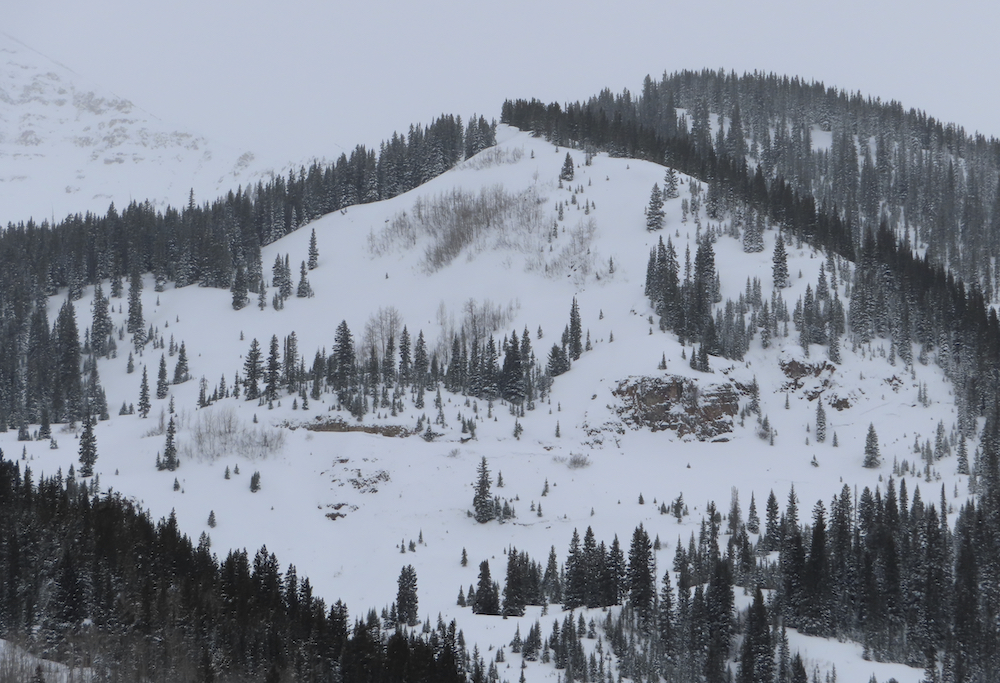
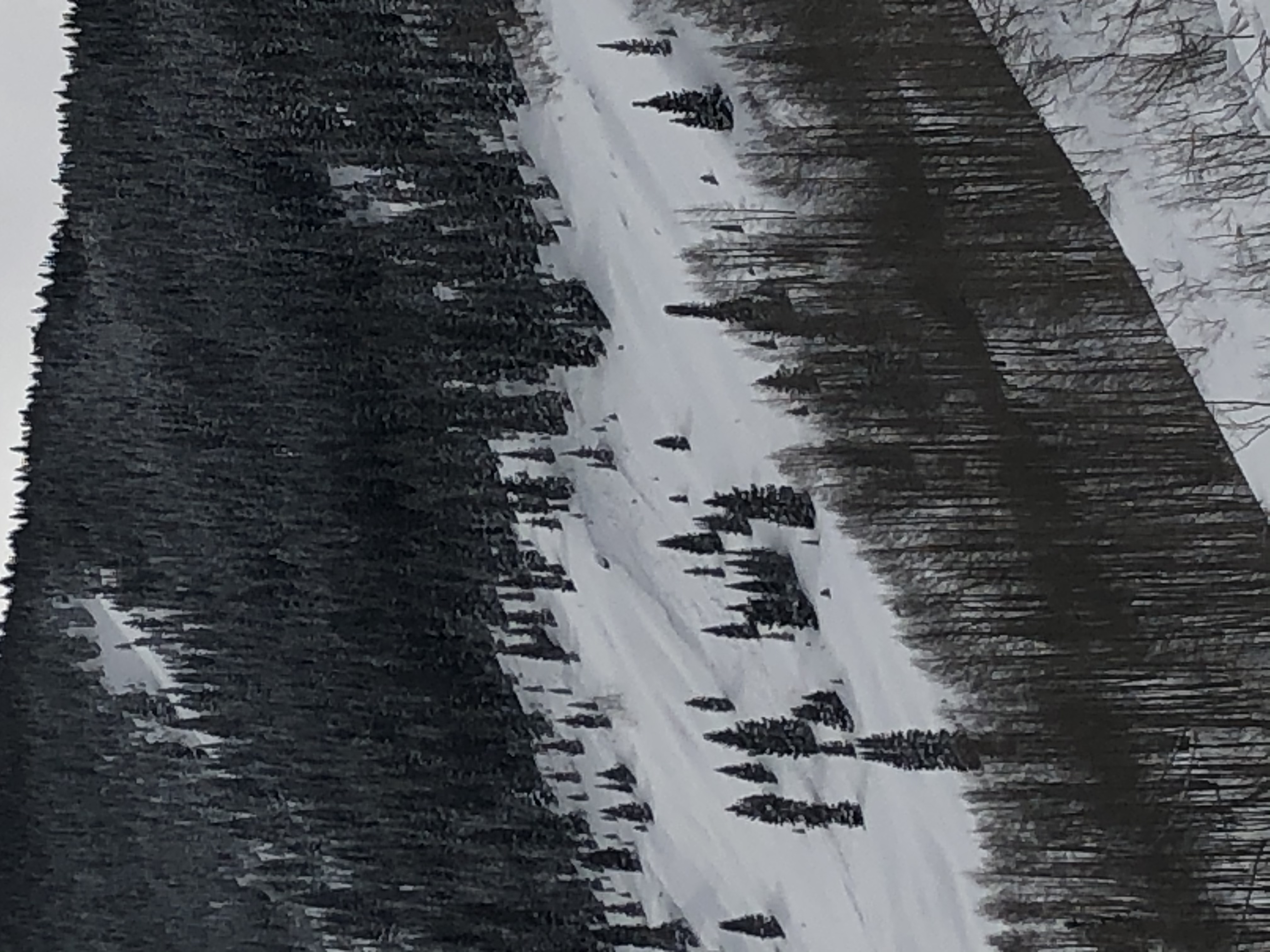
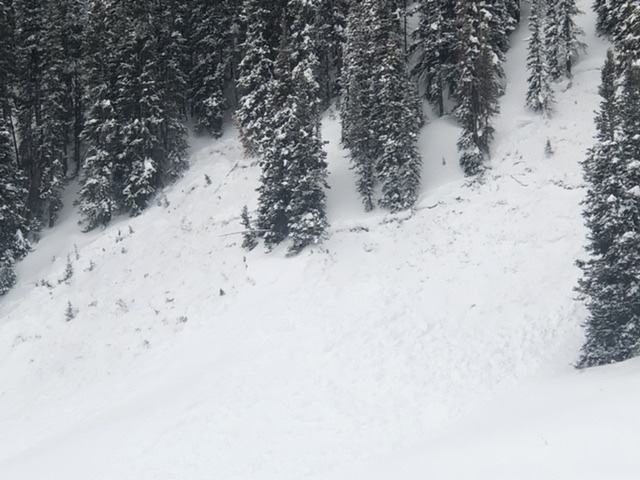
Avalanches: This short afternoon tour revealed plenty of recent avalanche carnage in the Slate River. These avalanches likely failed some time on 12/14. NE facing aspects were again the bullseye for activity, at both BTL and NTL, or both sheltered and wind-loaded slopes. The crown heights closer to Crested Butte looked a little smaller, while the crowns I got closer to in the Paradise Divide area, were about 1m deep on average. These avalanches were failing at the ground in the well-developed Facets and Depth Hoar. Many crowns were soft-looking as more recent snow and the wind was trying to hide them. It is certainly possible that some avalanches ran on mid-pack persistent week layers, but more investigation is necessary to make that determination. Avalanche size was mostly in the D2 range. Some smaller and some slightly larger.

Lots of interesting pocket avalanches and crown lines along Climax and Schuylkill Ridge that would be interesting to see why those crown lines failed the way they did. SH distributions, or old snow distribution maybe? The largest avalanches I observed were in the Purple Ridge Area. Of particular note, the palace proper looked to have several deep crowns spread through the main avalanche paths.

All in all, visibility sucked. Crown lines were already getting soft looking and debris were difficult see with these conditions. NE was the bullseye.

Weather: Overcast, light snow adding up to an inch or so, calm winds, and dropping temperatures.

Snowpack: The recent snow has really set up. Ski Pen 15 and Boot Pen 60cm. HS was now in the 100cm to 165cm range on the slopes we traveled. No obvious signs to instability.

Snodgrass Obs

CB Avalanche Center2019-20 Observations

Location: Crested Butte Area
Date of Observation: 12/15/2019
Name: Alex Tiberio
Subject: Snodgrass Obs
Aspect: North East

Elevation: 10,000
Avalanches:

Spotted 6 R1D1/2 slides on snodgrass between 1st bowl and abbey lane. All of them on the middle of the 3 pitches. Visibility is not the best. Only got a good pic of one on abbey lane. The others are all similar in size.

Photos:

Backyard avalanche

CB Avalanche Center2019-20 Observations

Location: Crested Butte Area
Date of Observation: 12/14/2019
Name:
Subject: Backyard avalanche
Aspect: North East

Elevation: 9500
Avalanches:

Small avalanche on hillside between Long Lake and Stream View Lane. Storm slab stepped down to persistent weak layer. Bed surface at ground level in multiple locations. 500 yards south of Washington Gulch parking area. Visible from the road.

Weather: Snowing heavily. Winds downslope, down valley

Photos:

Gothic 7am Update

CB Avalanche Center2019-20 Observations

Location: Crested Butte Area
Date of Observation: 12/15/2019
Name: billy barr
Subject: Gothic 7am Update
Aspect:
Weather: Cloudy with steady, strong wind Saturday and stronger gusts, up to about 40 mph. Generally light to no snow, mostly in the afternoon so a dense build-up. Then wind lets up with light to moderate snow ending by midnight. So 24 hour totals are 6½” new snow with 0.54″ of SWE. Currently 31″ on the ground, winters deepest and above average for this date (first time all winter). It is cloudy but calm (hooray). Low temp. 4ºF and currently 6 after a high of 27F. Did I mention no wind? billy

Mountain Weather For 11,000ft Sunday 12/15

CB Avalanche CenterWeather

Date: 12/15/2019

Winds have eased and become light overnight, while snowfall also tapered off after midnight. The moisture stream has now moved to our south. A short wave trough will be passing over Colorado today. Models show us staying just to the north of that main moisture feed, so if that holds up we are only talking about a little new snow this afternoon. If that model guidance is wrong and the moisture pushes a bit further north then we could see more snow adding up this afternoon and into the evening.

Heading into Monday the Temperatures will be dropping as we sit under northerly flow. The mountains will see high temperatures in the single digits and low temperatures in the negatives. By Tuesday a large high pressure will be overhead bringing clears sky and continued cold temperatures.

  • Today

    High Temperature: 16 to 20
    Winds/Direction: 5 to 15, NNW
    Sky Cover: Mostly Cloudy
    Irwin Snow: 1 to 3
    Elkton Snow: 1 to 3
    Friend’s Hut Snow: 0 to 2

  • Tonight

    Low Temperature: -6 to -2
    Winds/Direction: 5 to 15, NNW
    Sky Cover: Mostly Cloudy
    Irwin Snow: 0 to 2
    Elkton Snow: 0 to 2
    Friend’s Hut Snow: 0 to 2

  • Tomorrow

    High Temperature: 5 to 9
    Winds/Direction: 7 to 17, NNW
    Sky Cover: Mostly Cloudy
    Irwin Snow: 0 to 1
    Elkton Snow: 0 to 1
    Friend’s Hut Snow: 0 to 1

Gothic Obs

CB Avalanche Center2019-20 Observations

Location: Crested Butte Area
Date of Observation: 12/14/2019
Name: Steve Banks
Subject: Gothic Obs
Aspect: North East
Elevation: 9,500

Avalanches: None observed—poor visibility

Weather: 6-8” of new snow accumulation. Periods of S4 snowfall. Whiteout most of the day. Strong down valley (NW) winds which curiously shifted to up valley from time to time. Temps in the mid to upper 20’s. Around dusk the winds and snowfall tapered significantly.

Snowpack: Shooting cracks and collapse on small 36* East facing slope. Shovel tilt test failed repeatedly within the new snow while isolating or removing the column. Compression Test also failed on isolation (CTV) failing are the ground. Strong over weak structure observed, though in the location Basel facets were minimal and discontinuous. Most notable in our snow pit was the upside down new snow and storm slab failures.

Sensitive Snodgrass

CB Avalanche Center2019-20 Observations

Location: Crested Butte Area
Date of Observation: 12/14/2019
Subject: Sensitive Snodgrass
Aspect: East, South East
Elevation: BTL

Avalanches: Poor visibility prevented views of surrounding landscapes.

Weather: Variable weather. Overcast skies with periods of S-1, S1, and S2 snowfall, but mostly S-1. This snowfall really didn’t result in snow accumulation. Did notice graupel grains on the snow surface. Primary weather factor for snow accumulation were the winds, which were moderate at times with moderate snow transport, especially in unprotected areas. Temperatures were closer to freezing in the trees and in sheltered areas.

Snowpack: Shallow snowpack in the spruce with air pockets around branches and down trees. Collapsing and cracking on new skin track in the spruce, but isolated to the skin track.

Four hasty hand pits from the aspen through the spruce all had failures on a layer 6 inches below the snow surface. In wind affected areas, hand CT resulted in CT1 Q1. Other tests were CT2 and CTV Q2 but all on the layer about 6 inches below the snow surface. Failure layer is buried surface hoar?


Cement Creek Snow

CB Avalanche Center2019-20 Observations

Location: Cement Creek Area
Date of Observation: 12/14/2019
Name: Cosmo

Subject: Cement Creek Snow

Weather: Cement Creek @ 9400’, 8am Saturday—6.5” of snow over last 24ish hours bringing storm total thus far to to about 12”. Snow this morning seemed denser than the snow I shoveled yesterday morning. Plenty of wind blowing fresh snow around.


Mountain Weather for 11,000ft

CB Avalanche CenterWeather

Date: 12/14/2019

All the ingredients are lining up for another good dose of snowfall across our forecast area today into Sunday as the strong upper level jet stream slowly sags from the I-70 corridor southward into Gunnison County and the Elk Mountains tonight. Snow, heavy at times and strong westerly winds will continue throughout the day today creating near whiteout conditions near and above treelike once again. There may be a lull in snowfall midday, but should redevelop again this afternoon. Tonight, a sagging cold front will push the jet stream southward into the San Juans, shutting off the major moisture tap, but creating favorable west-northwest flow over our mountains into Sunday morning. Sunday should see improving visibility, backing winds and partial sunshine to return, especially in the afternoon.

  • Today

    High Temperature: 20-25
    Winds/Direction: 20 G40-50/WNW
    Sky Cover: Mostly Cloudy
    Irwin Snow: 4-8″
    Elkton Snow: 4-8″
    Friend’s Hut Snow: 3-6″

  • Tonight

    Low Temperature: 15-20
    Winds/Direction: 20 G40-50/W
    Sky Cover: Mostly Cloudy
    Irwin Snow: 2-4″
    Elkton Snow: 2-4″
    Friend’s Hut Snow: 1-3″

  • Tomorrow

    High Temperature: 15-20
    Winds/Direction: 15-25/NW
    Sky Cover: Decreasing clouds
    Irwin Snow: 1-3″
    Elkton Snow: 1-3″
    Friend’s Hut Snow: 0-2″