Observations

02/04/21

Cold and quiet

Date of Observation: 02/04/2021
Name: Con Rad

Zone: Southeast Mountains
Location: It’s a secret stash that no one knows about
Aspect: North East
Elevation: 10,400

Avalanches: Saw one in the furthest west gully on Gothic and some on N and NE facing steeper shots on Schyukill but viz was somewhat hampered by in and out light.

Weather: Lightly snowing off and on some winds from SW that was transporting snow. But I’m no meteorologist.

Snowpack: Ski pen 8″, no signs of instability where we were skiing. Seemed like the wet and warm start to the storm pasted into old tracks and then the cold dry snow finish was what we were skiing in. It also seemed like the wind blew up the slope and then down the slope. Or down the slope and then up the slope. Like I said, I’m no meteorologist.

Read Full Observation
02/04/21

Gothic 7am Weather Update

Date of Observation: 02/04/2021
Name: billly barr

Zone: Southeast Mountains

Weather: Strong wind yesterday with snow starting around sunset and ending by midnight, then clearing and cooling. New snow is 7″ with a dense wind driven 0.71″ of water. The snowpack sits at 36½”, just shy of winters deepest. Current clear and 5F after a low of 2F and a high yesterday of 38F. Wind continues but down from yesterday but a lot of snow blowing on ridgetops. So early day sign of avalanche activity.

Read Full Observation
02/04/21

Whetstone

Date of Observation: 02/04/2021
Name: Emilio Alcala

Zone: Southeast Mountains
Location: Whetstone Big Bowl
Aspect: North East
Elevation: 12,500

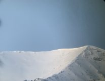
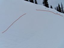
Avalanches: NE face Big bowl, Large Avalanche D2.5? R2
Weather: Clear morning following large loading event high winds yesterday and significant snowfall

Photos:

Read Full Observation
02/04/21

6″ up Cement Creek

Date of Observation: 02/04/2021
Name: Cosmo Langsfeld

Zone: Southeast Mountains
Location: Cement Creek Ranch
Elevation: 9250′

Weather: At 9pm there was 3″ at the trailhead and 4″ at the ranch. An additional 2″ fell at the ranch overnight.

Read Full Observation
02/03/21

Weak structure on the border of NW and SW mountains.

Date of Observation: 02/03/2021
Name: Jack Caprio & Zach Kinler

Zone: Southeast Mountains
Location: Lower Wolverine
Aspect: North East, East, South East, West
Elevation: 9,000′-10,200′

Avalanches: None observed
Weather: Light graupel early in the morning, periods of very light snowfall (S-1) before noon. SW winds increased from moderate to strong as we left for the car around 12 pm.
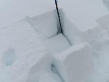
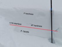
Snowpack: We were curious to see how the snowpack structure looks on the border of our SE and NW mountains before the loading event. We traveled in below treeline areas mainly on west and east aspects. Our average HS was 80 cm. Generally, we found a 30-35 cm slab sitting on top of the 1/19 interface. The 1/19 interface consisted of incredibly soft (F-) large faceted grains. The slab hardness increased as you got deeper in the snowpack reaching 4F near the bottom of the slab.

On a small east facing convexity, we produced a loud collapse along with shooting cracks that radiated throughout the top of the convexity. A quick compression test near the collapse produced failure on the 1/19 interface during isolation of the column. After a couple more loud collapses, we decided to ski mellow creamy pow down to the road. The current slab is sitting on top of an extremely weak structure, we suspect it won’t take much new loading before we see results in these shallow, weaker areas of the forecast zone.


Photos:

Read Full Observation
02/03/21

Cement Creek Snow

Date of Observation: 02/03/2021
Name: Cosmo Langsfeld


Zone: Southeast Mountains
Location: Cement Creek Ranch
Aspect:
Elevation: 9250′

Weather: Just a skiff of new snow at 5:30am. Snowing lightly.


Read Full Observation
02/02/21

Its warm out there on Snodgrass

Date of Observation: 02/02/2021
Name: Eric Murrow


Zone: Southeast Mountains
Location: Snodgrass front side
Aspect: North East, East, South East, South
Elevation: 9,300′ – 10,600′


Avalanches: nothing new observed
Weather: Mostly cloudy skies early transitioned to partly cloudy skies in the afternoon. Mild air temps – felt a bit above freezing (weather stations confirmed temps in upper 30’s). Calm winds.
Snowpack: Traveled through a quiet area on the front side of Snodgrass as snow depths in this area match well with other shallow snowpack zones in the Southeast Mountains. East through South slopes was moist at the surface to the highest elevation I traveled – 10,600′. Some northeast meadows were moist below about 10k. Ski penetration on east and northeast slopes was around 6 to 8 inches with snowpack depths around 70cm on east and 90cm on northeast; boot penetration to ground everywhere. Settlement in the snowpack over the past few days was noticeable. Slabs above the mid-January weak layer were in the 25 to 30cm range with 4finger hardness at bottom of slab which I think fits nicely with other sheltered areas in the Southeast Mountains (snowpack tests all produced moderate ECTN scores).  Overall the snowpack is weak and even a modest loading event, say around 10 to 12inches, will likely start producing avalanches.

Photos:

[/gravityforms]

Read Full Observation
01/31/21

Mt. Bellview Natural Cycle

Date of Observation: 01/31/2021
Name: Bo Torrey (via Billy Barr Camera)


Zone: Southeast Mountains
Location: Mount Bellview
Aspect: East, South East, South
Elevation: 12,200-11,600


Avalanches: Natural loose snow avalanches ran down and sympathetically triggered 6 large slab avalanches. The first round of avalanches occurred shortly after 11:00 AM the second round closer to 2:00 PM. Videos of the slides are visible from Billy Barrs North Camera. (Thanks Billy!!)
Weather:
Snowpack:


Photos:

Read Full Observation
01/30/21

Roadside avalanche obs with poor vis

Date of Observation: 01/30/2021
Name: Eric Murrow


Zone: Southeast Mountains & Northwest Mountains

Avalanches: Visibility was tantalizingly poor all day. Just enough vis for a few seconds to spot some natural avalanche activity. Observed a number of dry loose avalanches above treeline on Gothic and Scarp Ridge. Two small Wind Slabs spotted on WSC Peak and Whetstone.  I never left the pavement.

Photos:

[/gravityforms]

Read Full Observation
01/30/21

Anthracite Mesa-Coneys

Date of Observation: 01/30/2021
Name: Andrew Breibart


Zone: Southeast Mountains
Location: Coneys
Aspect: North East, East, South East
Elevation: BTL


Avalanches: Observed three wet loose slides on the west facing gullies of Gothic. Not much snow was entrained and starting zones were partially exposed cliff bands. I assume these ran between Thursday or Friday (1/28/21-1/29/21).
Weather: Paradise Divide and mountains in the NW zone west of the Anthracites were under obscured skies. In area of observations, mostly cloudy skies with periodic afternoon S-1 and S1 snow. lLight winds in the valley bottom with no snow transport and moderate winds at the ridge lines. Snow and wind didn’t result in additional loading of the bowls. Exception is summit ridge line had minimal snow loading just below ridge.
Snowpack: Traveled off skin track in open areas as much as one can in this area. No cracking or collapsing off the skin tracks. Hand and ski pole probing of the skin track cuts revealed a 1F sun crust on the SE aspect (1/19 interface?). It was about one inch thick about 6 to 8 inches below the surface Ski pen off skin track ranged between 6 and 12 inches. Stomped a wind lip on the ridgeline and stomped around the summit rollover. Nothing cracked, collapsed, or moved. Trace of new snow today from S1 snowfall.


Read Full Observation
The blog.