By Arden Feldman CBAC Intern
The week began clear and warm on February 17th but high clouds began to build on the 18th from a deep Pacific trough making landfall on the California coast. Moisture associated with the trough began streaming in from the southwest on the 18th but unfortunately the bulk of the energy and precipitation remained out near the west coast. Accumulations were only marginal with occasional light snow showers into the 19th. On the afternoon of the 19th a low pressure trough moved over Colorado, bringing with it a warm, moist air mass with southerly flow. This system brought snowfall through the night and resulted in 2 to 8 inches of snow across our area by the morning of the 20th, favoring the Kebler Pass and Paradise Divide zones. Strong westerly winds accompanied the new snow.
A temporary ridge built overhead on the 20th allowing for scattered skies and warm temperatures. Another Pacific trough began to move onshore on the 21st, quickly breaking down the ridge. Associated moist southwest flow stayed to our north and west in Wyoming and Utah. Being on the edge of this flow we saw increasing clouds and strong winds on the 21st and 22nd. The Elkton weather station recorded a 102 mph gust on the 21st. Finally on the morning of the 23rd a cold front drifted south over the Elk Mountains and brought steady snowfall with it. 8 to 10 inches of snow, driven by strong west to northwest winds, accumulated on the 23rd. The Schofield Pass Snotel Site recorded .5” of SWE and 10” of snow.

2/20/17 – Satellite image showing the break between storms on February 20th and the approaching system that would bring 100+ mph wind gusts and a quick blast of snow.
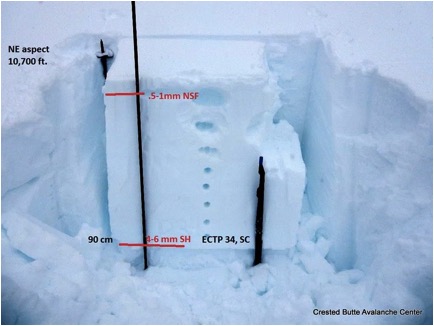
Persistent slabs on buried surface hoar 1 to 3 feet deep were the avalanche problem in the beginning of the week. The slabs were becoming increasingly unreactive but were still possible to trigger on near tree line northerly slopes. By the end of the week they had become unlikely to trigger. No new persistent slabs were observed this week and the last reported persistent slab occurred on February 14th in the Aspen Zone.

2/20/17 – Snow pit showing a 3 foot slab over propagating surface hoar on a NE aspect near tree line.
The new snow and strong westerly winds on the afternoon of the 19th built wind slabs on leeward aspects near and above tree line, and wind slabs were added to the problem list on the 20th. With continued strong winds and more snow on the 23rd, the wind slabs stuck around through the end of the week and kept the avalanche danger rating at moderate near and above tree line. They remained possible to trigger and small to large in size. During the second half of the week, several wind slabs were skier triggered and were responsible for a couple of close calls (Coon Basin, Purple Peak).


