Thanksgiving and avalanches

CB Avalanche CenterAvi Blog, Avi-Off-Season

Thanksgiving and avalanches. By Zach Guy
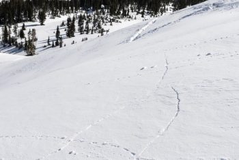

Shooting cracks are a sign that the snowpack might have taken a few too many scoops of mashed potatoes and stuffing.

It has been a wonderfully warm and dry fall, which is hard to complain about. But if we can be brutally honest with the weather gods, fall really was starting to wear out its welcome, and we are happy to open the door to winter. There’s nothing quite like surfing over powder, so it’s time to dust off those skis, find your beacon, shovel, and probe, and start tuning into our daily avalanche reports.

Early season skiing and riding comes with some challenges and risks. The snow coverage is still quite shallow, so striking rocks and logs are tough to avoid and they can end your season pretty quickly. My strategies include getting on the fattest skis I can find, riding like a gaper in the backseat, and using releasable bindings in case my tips dive under a log or rock. I’ve seen a few too many broken tib-fibs from early season riding. And of course, we all want to go to where the snowpack is deepest, which can open the doors to another scary threat: avalanches. This time of year, the slopes holding deep and continuous coverage often carry the greatest risk of triggering an avalanche. It is almost impossible to go through fall without a shallow, crusty, and faceting foundation forming on the ground. Then once we start building a deeper snowpack, it creates a persistent slab avalanche problem above these layers.


Skier triggered slides in Red Lady Bowl

I like analogies, so let’s compare our current year’s snowpack to your most recent Thanksgiving celebration. You probably avoided food all day, maybe even went for a turkey trot to work up an appetite in preparation for the big feast. A significant drought, indeed. That left you weak and frail, just like the lingering snowpack layers that survived our fall drought. Then once dinner time (i.e. winter time) rolled around, you started off at a decent pace. Snacked on some hor devoirs, some salad, maybe some of your Uncle’s famous deviled eggs or your Grandma’s bean dip. Our first few storms behaved in similar fashion, fairly small and steady loads, with a handful of isolated avalanches. Nothing too scary yet. Then it is dinner time: you go for the mash potatoes, stuffing, turkey, green bean casserole, and of course drown it all under gravy. Extra rolls? Why not? Whammo. That’s a heavy load, just like our last storm, which dumped almost 2 feet in places. Both scenarios are dangerous. You could collapse on the couch just as easily as you could collapse those fragile weak layers near the ground. During and after the storm, we saw both natural and skier triggered avalanches, some quite large and surprisingly wide. As of Tuesday night, I’m expecting we’ll see evidence of a lot more avalanche activity as we get better visibility over the next few days. So tread carefully out there, and check the avalanche report before you go out. So what’s next for our snowpack? Does it reach for another plateful of mashed potatoes before slamming down some pumpkin pie and faceplanting onto the floor? Or does it slowly nibble at the leftover turkey and try to stay awake for family charades? Only the weather can dictate that one. But you can be the captain of your risks by making rational decisions and practicing your rescue skills. Is it a coincidence that this Friday night is our Annual Avalanche Awareness Night, with the theme “Human Factors and Decision Making”? Or that Saturday is our annual Beacon Brushup, a free and valuable opportunity to dial in your rescue skills for the winter? I think not. See you there!

Human Factors and Decision Making

CB Avalanche CenterAvi Blog, Avi-Off-Season

Human Factors and Decision Making

By Zach Guy, CBAC Director

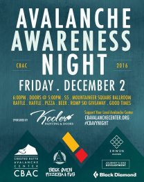
This year’s theme to CBAC’s Avalanche Awareness Night on December 2nd, 2016 is “Human Factors and Decision Making”. Almost all avalanche accidents are triggered by the victim or a member of their group. We are the ones who expose ourselves to avalanche risks, and often it is our own decision making that puts us into trouble.

Although humans have been pondering our methods of thinking and rationalizing for centuries, Ian McCammon has been instrumental in research in the avalanche industry. I was fortunate enough to have Ian as a course instructor and mentor for my AVPRO class about 7 years ago, and caught up with him to ask a few questions about human factors and decision making.

Ian McCammon. Photo courtesy of POWDER magazine.

Zach Guy: Ian, you have a PhD in mechanical engineering, and a Master’s in Material Science. In the avalanche world, you are well known for your research on human decision making. What inspired your shift in focus from physics towards psychology?

Ian McCammon: My own journey started years ago when a friend of mine died in an avalanche. Using tools from my engineering background, I searched for statistical trends in hundreds of past accidents and found that the circumstances of my friend’s death followed a pattern that repeated itself again and again: risk perception for certain groups was distorted under certain conditions.

Zach: In 2002, you published a paper on heuristic traps and how these human factors affect our decision making and influence avalanche accidents. The acronym “FACETS” (Familiarity, Acceptance, Consistency, Experts, Tracks/Scarcity, and Social Facilitation) has been adopted by essentially every avalanche course around the country to introduce these human factors. My talk at Avalanche Awareness Night will dive into some of these factors and a close call that I had back in 2009. In your research or simply from personal experience since then, are there any other human factors that you think backcountry travelers should be aware of?

Ian: Fatigue is an important physiologic factor that influences our decision making. When you are tired, dehydrated, hungry, cold or just sucking air from a long ascent, it’s hard to judge hazards objectively. And just like the FACETS cognitive traps, fatigue is dangerous because people consistently underestimate how profoundly it can impair their judgement.

Zach: You developed some systematic tools to help backcountry travelers overcome our human biases, such as ALPTRUTH and Lemons. Do you have any other personal tips or strategies that you use in your ski tours for overcoming the inherent biases in the way our brains process information and make decisions?

Ian: ALPTRUTh was designed to do two things. First, it stops you at the cusp of a decision – it breaks the momentum that sometimes carries people into trouble. Second, it helps you see how your group’s decision will be viewed should an accident take place – a process called a pre-mortem. There are other ways to do this, and my hope is that new and better tools will emerge from research into this important area.
Another strategy in addition to APLTRUTh is to choose your partners wisely. Choose people with the wisdom to stop the group’s momentum at the right times and reconsider evidence and the opinions of the group. If they can do that, it’s going to be less frustrating and more effective to manage risk as a group.

Zach: Social media has exploded since your original research 15 years ago. We have a presenter who will be touching on this subject at Avalanche Awareness Night. With Facebook, Instagram, Youtube, etc., the entire internet is watching what we do in the backcountry. What is your take on the impact of social media on our decision making, and do you suggest or have any strategies for handling its potential influences?

Ian: This is a fascinating and worthy topic for research. I am glad you have a presenter exploring this subject. Some folks are choosing to literally create their social identities in near-real time as their decisions and outcomes are posted and amplified across an audience of friends and potential critics. An important question for each of us is how much are we willing to allow that unseen audience to shape our critical decisions.

Zach: Any parting words for our Colorado audience that recreates in the deadliest snowpack in the country?

Ian: To paraphrase Baltasar Gracian: Know your major weakness. If you do not understand it, it will rule you like a tyrant.

Zach: Thank you Ian for sharing your wisdom, and for your contributions to the avalanche industry.

 Join us at CBAC’s Avalanche Awareness Night for more great presentations on human factors and decision making.

Backcountry Etiquette

CB Avalanche CenterAvi Blog, Avi-Off-Season

By Zach Guy – CBAC Director
Backcountry recreation is a rapidly growing industry in the West, and equally rampant in our little valley. As the mountain regions around the U.S. becoming increasingly busy during the winter, there have also been an increase in close calls and conflicts between user groups pertaining to avalanche safety.
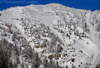
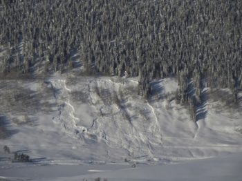
Several years ago, on an easily accessible peak near Teton Pass, a backcountry skier triggered a huge slab avalanche, upwards of 8 feet deep.  The slide ran thousands of feet, plowing along a drainage that is a popular access and egress point for relatively safe tree skiing.  Debris piles were monstrous, and the resulting public outcry was equally monstrous.  You can read more about the Taylor Mountain slide here. Similar issues have arisen in the Wasatch, some of the passes around Colorado, and more.  As the backcountry becomes more crowded, our need for responsible etiquette increases.  In most cases, it is to protect our fellow backcountry enthusiasts.  But in some cases, we are jeopardizing the safety of the general public who is unknowingly walking or driving their car beneath the avalanche path that you are skiing or riding.  
The slide on Taylor Mountain near Teton Pass. The skier was conducting an intentional ski cut, but the slide went much larger than expected.  Photo courtesy of TetonAT.com
Debris piles were 10-12 feet deep in the Coal Creek drainage, a launching and exit point for many backcountry skiers looking to get into relatively safe terrain.  Photo courtesy of TetonAT.com.
At the CBAC, we have been hearing feedback that our community needs a reminder about backcountry etiquette.  Even our small town has issues with over-crowding in the backcountry.  Observers have noted multiple instances where groups of skiers descended upon another group climbing the same avalanche path.  I’ve always been impressed with the attitude and etiquette of backcountry users in this community. We share observations of snowpack and avalanches, we look out for each other’s interests while on slope, and we don’t seem to hold the territorial or secretive attitudes that many ski towns around the U.S. have.  That’s one reason why I’ve chosen to live here.  Lets not lose that consideration for our community in the backcountry as more people migrate to this great backcountry destination.

So what does backcountry etiquette mean?  Simply put, be aware of your actions and their consequences in the backcountry, because they don’t solely affect you.  If you trigger an avalanche, will it affect someone down slope of you?  Communicate with people you encounter on your tours; discuss your routes and how you can avoid crossing above or below each other.  A few days ago, I found myself on top of the Anthracites on a powder day with over a dozen powder-starved locals eager to drop in.  All of the groups did a great job of communicating and divying up the terrain so that we didn’t all get bunched up on one avalanche path.  If you see a group climbing up your intended descent route, wait for them or choose another route. Its simply not worth putting them in the line of fire.  Cornice drops and ski cuts can be a great slope test, but are you absolutely sure that no one will be affected below you? Think about the size and possible extent of an avalanche that you could trigger.  Under some conditions, a slide on Red Lady Bowl or above Peanut Lake Road or on Snodgrass could run across roadways of innocent commuters.  And just as importantly, if you get injured or killed in a slide, the impacts reach far beyond just you. You have family members, friends, and community members that will be deeply impacted.

This is a natural avalanche that crossed Peanut Lake Road and the nordic track 2 winters ago.
Winter is just underway here in the Crested Butte area as our shallow and weak snowpack is starting to get buried.  We will undoubtedly see dangerous avalanche conditions developing once we see some big storms.  Lets kick winter off right. Consider your safety and the safety of others by bringing an improved sense of backcountry etiquette to the Elk Mountains.

Mt. Baldy

CB Avalanche Center2015-16 Observations, Avi Blog, Avi-Off-Season

Location: Paradise Divide Area
Date of Observation: 10/25/2015
Name: Dustin
Subject Mt. Baldy
Aspect:
Elevation: Above treeline

Avalanches: Observed a previously triggered point-release on a W – NW aspect near WSC bowl on Baldy. Likely occurred 10/23.
Weather: Warm and clear during the days with clouds increasing Sunday.
Snowpack: Most snow accumulation is around 11,000 feet and above. Little avalanche potential otherwise as there is simply not enough snow to form slabs. The exception is up high in very windloaded areas. A snowpit around 12,700 feet on a E-facing windloaded slope (Treasury) showed a pack of 110 cm with uniform layering . ECTN. Typical mixed bag of conditions elsewhere where snow had accumulated with suncrusts, wind crusts, and dry snow in the suspect areas. Did find basal crust on rocks under dry snow on N-facing slopes around 11,000.

2015.10.25_Baldy

Spring Travel Advisory 2015

CBACAvi Blog, Avi-Off-Season

Issued 4/6/15 by CBAC

Spring season is a great time of the year to get into the mountains and generally offers better stability and more manageable avalanche problems for backcountry travelers.  However, avalanches conditions can still be dangerous during spring, and there are several kinds of problems you should continue to monitor and assess in you springtime adventures.


-Storm instabilities

Spring snowfall will usually fall on some form of crust.  These surfaces do immediately bond well.  Anytime a slab of new or windblown snow forms, expect touchy conditions during and shortly after the storm.  New snow becomes especially sensitive as the sun comes out immediately after the storm and quickly consolidates into more of a storm slab.   Expect leeward and crossloaded features at higher elevations to hold thicker and more sensitive windslabs  following a storm with moderate or strong winds.  These kinds of instabilities are generally short-lived during the springtime, but can last for several days after the storm on shaded aspects or higher elevations. The best strategy is to monitor how much snow accumulates during a storm and ease into small and manageable terrain until you’ve assessed how large and how sensitive new slabs are.  Be wary of windloaded slopes and avoid heavily windloaded features following a significant storm.  The Schofield Pass SNOTEL, which is northwest of town, and the Butte SNOTEL, which is on Mt. Crested Butte, are local remote snow sensors that update hourly.  Storm or wind slabs are most problematic over consequential terrain with cliffs, gullies, long vertical, or rocks and trees.

-Wet avalanches

When the sun (or rain) comes out after a spring storm and moistens the new snow, loose wet avalanches become frequent on any slope steeper than 35 degrees, and these point releases typically fan out and entrain all of the new snow down to previous crust layers.  These are usually small and predictable, but can carry significant mass after a large storm or in terrain with significant vertical relief.  They can also run when old snow looses cohesion as crusts thaw, and have potential to entrain a large amount of snow during prolonged warm-ups.   Wet slabs can be a larger and more dangerous problem. These are caused by liquid water percolating to and compromising the strength of buried weak layers.  This year, our snowpack is about a month ahead of schedule, meaning our April avalanche problems are more typical of May problems.  Most slopes facing east through south through west, as well as lower elevations that face north, have seen water run through the entire snowpack and have already been delivered the dry to wet “spring shock”.  These slopes saw a wet avalanche cycle in mid-March.  A number of these slopes have matured into a stable, spring snowpack, but it is difficult to identify which ones could still be harboring the threat of a wet slab.  Northerly facing slopes near and above treeline have seen less, if any, meltwater, and still primed for wet slab activity when temperatures and the higher sun angle turn on the water factory.  Last year, these slopes began their wet slab cycle around late May to early June.  The size of wet slabs failing on deeply buried weak layers will be likely be large at these elevations.  Wet slabs are most likely to occur during prolonged warm-ups and/or following multiple nights without a good refreeze.  If we see a dust-on-snow event, this will expedite surface warming.  Wet avalanche danger is usually lower in the morning and rises through the day. The best strategy is to exit avalanche terrain early during warm, sunny days or avoid it during rainy days.  Monitor how well the snow surface refroze overnight, and time your descent so that you are riding in a couple inches of supportive corn skiing, rather than punchy, trap-door snow or ankle deep slushy snow.  Look for evidence of recent wet avalanches on similar slopes to clue you in to dangerous conditions.  Monitor mountain temperatures from these weather stations and expect cloudy nights to prevent a better refreeze.

-Cornice Falls

Springtime is the season that large cornices that have been growing all season begin to weaken and fall.  These can also be triggers for slab avalanches.  Cornices tend to break wider than expected.  Give cornices a wide berth if you are traveling along a corniced ridgeline, and limit your amount of exposure climbing underneath cornices, especially during the peak of warming.


The CBAC will continue to monitor the snowpack and post updates to our website and our facebook page if conditions warrant.   The CAIC will issue statewide updates on Mondays, Wednesdays, and Fridays into the spring season.  

Spring Travel Advisory 2015

CB Avalanche CenterAvi Blog, Avi-Off-Season

Issued 4/6/15 by CBAC

Spring season is a great time of the year to get into the mountains and generally offers better stability and more manageable avalanche problems for backcountry travelers.  However, avalanches conditions can still be dangerous during spring, and there are several kinds of problems you should continue to monitor and assess in you springtime adventures.


-Storm instabilities

Spring snowfall will usually fall on some form of crust.  These surfaces do immediately bond well.  Anytime a slab of new or windblown snow forms, expect touchy conditions during and shortly after the storm.  New snow becomes especially sensitive as the sun comes out immediately after the storm and quickly consolidates into more of a storm slab.   Expect leeward and crossloaded features at higher elevations to hold thicker and more sensitive windslabs  following a storm with moderate or strong winds.  These kinds of instabilities are generally short-lived during the springtime, but can last for several days after the storm on shaded aspects or higher elevations. The best strategy is to monitor how much snow accumulates during a storm and ease into small and manageable terrain until you’ve assessed how large and how sensitive new slabs are.  Be wary of windloaded slopes and avoid heavily windloaded features following a significant storm.  The Schofield Pass SNOTEL, which is northwest of town, and the Butte SNOTEL, which is on Mt. Crested Butte, are local remote snow sensors that update hourly.  Storm or wind slabs are most problematic over consequential terrain with cliffs, gullies, long vertical, or rocks and trees.

-Wet avalanches

When the sun (or rain) comes out after a spring storm and moistens the new snow, loose wet avalanches become frequent on any slope steeper than 35 degrees, and these point releases typically fan out and entrain all of the new snow down to previous crust layers.  These are usually small and predictable, but can carry significant mass after a large storm or in terrain with significant vertical relief.  They can also gouge deeper and grow larger entraining the full snowpack during prolonged warm-ups.   Wet slabs can be a larger and more dangerous problem. These are caused by liquid water percolating to and compromising the strength of buried weak layers.  This year, our snowpack is about a month ahead of schedule, meaning our April avalanche problems are more typical of May problems.  Most slopes facing east through south through west, as well as lower elevations that face north, have seen water run through the entire snowpack and have already been delivered the dry to wet “spring shock”.  These slopes saw a wet avalanche cycle in mid-March.  A number of these slopes have matured into a stable, spring snowpack, but it is difficult to identify which ones could still be harboring the threat of a wet slab.  Northerly facing slopes near and above treeline have seen less, if any, meltwater, and still primed for wet slab activity when temperatures and the higher sun angle turn on the water factory.  Last year, these slopes began their wet slab cycle around late May to early June.  The size of wet slabs failing on deeply buried weak layers will be likely be large at these elevations.  Wet slabs are most likely to occur during prolonged warm-ups and/or following multiple nights without a good refreeze.  If we see a dust-on-snow event, this will expedite surface warming.  Wet avalanche danger is usually lower in the morning and rises through the day. The best strategy is to exit avalanche terrain early during warm, sunny days or avoid it during rainy days.  Monitor how well the snow surface refroze overnight, and time your descent so that you are riding in a couple inches of supportive corn skiing, rather than punchy, trap-door snow or ankle deep slushy snow.  Look for evidence of recent wet avalanches on similar slopes to clue you in to dangerous conditions.  Monitor mountain temperatures from these weather stations and expect cloudy nights to prevent a better refreeze.

-Cornice Falls

Springtime is the season that large cornices that have been growing all season begin to weaken and fall.  These can also be triggers for slab avalanches.  Cornices tend to break wider than expected.  Give cornices a wide berth if you are traveling along a corniced ridgeline, and limit your amount of exposure climbing underneath cornices, especially during the peak of warming.


The CBAC will continue to monitor the snowpack and post updates to our website and our facebook page if conditions warrant.   The CAIC will issue statewide updates on Mondays, Wednesdays, and Fridays into the spring season.  

Absurduary: A look at our warm and dry start to 2015.

CB Avalanche CenterAvi Blog, Avi-Off-Season

CBAC Forecaster Zach Guy.  
February 12, 2015

In the past few weeks, I’ve seen streams emerge from high elevation basins, sunny slopes melt back to complete dirt, and a migration of locals towards the desert for mountain biking or sun bathing.  I’ve only lived in Crested Butte for four years, but this pattern seems so absurd for a high Rockies mountain town at 9,000 feet in elevation, that I dug into some historical weather to see how unusual this weather has been.

Since the New Year, we’ve been plagued by both snowfall drought and unseasonably warm temperatures.  The temperatures have been the greatest anomaly this winter.  billy barr in nearby Gothic has an exceptional record of temperatures and snowfall dating back to 1974 (www.gothicwx.org).  As of Friday, February 12th, 17 out of our 43 days this year have seen record-breaking high temperatures.  There have only been two days in February that didn’t break a temperature record, and we are currently going on 8 days in a row of record high temps. I expect the next two days will break records too.  On February 6th, the temperature hit 52 degrees F, which was a full month earlier than we’ve ever seen temps reach into the 50’s.  I think my brother in Florida is having a colder winter right now.

Looking towards Red Lady Bowl and some dirt slopes down lower.  Last year on this date, I dug a pit on a similar slope as that dirt slope in the foreground and found a 2 meter deep snowpack.


Snowfall droughts this time of year aren’t quite as unusual as the temperatures we’ve seen.  I looked at both Gothic snowfall and records from the town of Crested Butte, which date back to 1962.  (http://www.crestedbutte-co.gov)  In Crested Butte, where the average snowfall in January is 41.6”, we got 10.6” of snow last month.  There have only been four other January’s that saw less snowfall in the past 52 years.    February is off to a rough start as well, with only a few inches.  If it makes you feel any better, the winter of ’76-’77 only saw a total of 3” of snow from December through February in Crested Butte.  Too bad they didn’t have fat bikes back then. Gothic has fared marginally better on snowfall.  They saw 27” in January, which is 41% of average and the 8th lowest January on record.  Gothic picked up 6” in February, which is on pace to come up at 21% of the 70” average for February. Thanks to a healthy November and December, Schofield Pass SNOTEL is sitting at 67% of mean (3rd lowest snowpack in its 30 year record), and the Mt. Crested Butte SNOTEL is at 80% of its mean.

As someone who loves the winter, I can’t help but feel gloomy over the past couple months.  However, models keep hinting at a pattern change coming later this month or in March, for the warm and dry high pressure ridge to shift west and put us back into the storm track.  We’ll see…  And also worth noting, the horrible snow year of ’76 to ’77, which was the lowest on record at 61” in Crested Butte, was followed the next winter by the highest snowfall on record, at 381”.  I’ll stick around next winter to see what happens!

Looking towards Mt. Crested Butte.  Looks more like late April than early February.

What are facets?

CB Avalanche CenterAvi Blog, Avi-Off-Season

By Zach Guy
CBAC Forecaster
If you’ve been reading our avalanche advisories lately, you’ve probably noticed we’ve been talking a lot about facets.  Last weekend, major winter storm slammed into our mountains, and we saw widespread avalanche activity, with facets being one of the major culprits.  So what is the deal with this snow grain type, how does it form, and why is it so problematic?
Facets are a sugary-like snow grain.  They glisten in the sun, bounce in your glove, and commonly make a noticeably soft or hollow layer in the snowpack.  If you look at them under a magnifying glass, they have many flat edges, hence the name facets.  
Courtesy Photo
There are several different ways that can cause snow grains to facet, but they all share the same underlying physical process.  Facetsform when water vapor moves quickly through the snowpack. Each particle gets handed off between grains, via sublimation and deposition, causing the grains to reconfigure into a more angular form.  Strong temperature differences within the snowpack cause this water vapor relay.  We can see facets form early season when the ground is quite warm, there is a shallow snowpack, and the air gets cold, especially at night.  This drives the water vapor upward through the snowpack causing it to facet, or rot out.  We also see a similar process occurring on top of the snowpack, called “near surface faceting.”  When we get warm days and cold, clear nights, the snow surface undergoes wild temperature swings, causing the same rapid water vapor movement. This process is expedited if the surface is composed of soft, low density snow, rather than stiff, hard, compacted snow.  All of these ingredients have come together this winter.  We have seen basal facets form during the early season when our snowpack was shallow.  Then, on December 1st, we got about 4″ of new, low density snow, which was followed by two weeks of warm days and cold, clear nights.  That surface snow metamorphosed into fragile, sugary grains, and we didn’t get strong winds that can sometimes destroy that layer as it is forming.  On December 13th, that near surface facet layer was buried, and it is now under the weight of all the new snow that has fallen in the past 2 weeks.
Facets form a type of layer in the snow coined as a “persistent weak layer.”  So once a layer of facets gets buried by a slab of new or windblown snow, it makes for a weakness in the snowpack on which avalanches can fail.  Worst of all, the weakness is long-lasting, so we can see avalanches fail on facet layers weeks or months after they are buried.  This means that we can see very large slabs of snow develop over the course of the winter before a facet layer might finally give out, causing a huge avalanche.  Facets have a few other nasty tricks up their sleeves.  If the layer is fairly continuous, it is so fragile that it can drive a failure very long distances across avalanche terrain.  I’ve seen avalanches fail almost a mile wide on facet layers!!  If you can get the layer to collapse on flat terrain, it can propagate up a slope and cause an avalanche to release above you.  So not only do these layers plague us for long periods of time, but they also behave in an unusual manner.  Keep this in mind in upcoming weeks and months, now that we have several facet layers buried in our snowpack.   For more information or to get daily avalanche advisories, visit www.cbavalanchecenter.org.

This is a photo of a shallow slab that propagated impressive distances on the December 13th facet layer, near Purple Palace.  Photo credit: Aaron Huckstep

Ian’s Weather Resources

CB Avalanche CenterAvi Blog, Avi-Off-Season

 Current Data

Surface:

    http://weather.rap.ucar.edu/surface/
    https://avalanche.state.co.us/obs_stns/stns.php
    http://mesowest.utah.edu/cgi-bin/droman/mesomap.cgi?state=CO&rawsflag=3
    Schofield SNOTEL: http://www.wcc.nrcs.usda.gov/nwcc/site?sitenum=737

Upper-air soundings:

    http://weather.rap.ucar.edu/upper/

Radar & Satellite:

    http://www.weathertap.com ($84/yr, great mobile website as well)

Discussions

    NWS: http://www.nws.noaa.gov/view/prodsByState.php?state=CO&prodtype=discussion
    OpenSnow: http://opensnow.com/dailysnow/colorado
    CAIC: http://avalanche.state.co.us/forecasts/weather/zone-forecast/
    http://wasatchweatherweenies.blogspot.com

Forecast Models: Twisterdata.com

Top Center

NAM = 84hr 12km resolution

GFS = 384hr 27km resolution

RAP = 18hr 13km resolution

Left Side

700mb = orographic wind direction

500mb = vorticity

300mb = jet stream

Upper Right

Clickable map = one forecast image

Animated loop = all forecast images

Compare models = toggle between each model

dProg/dt = see the trend in the forecasts
Forecast Models: CAIC

    High-resolution version of the NAM model
    Graphics: http://avalanche.state.co.us/forecasts/weather/model-forecasts/
    Points: http://avalanche.state.co.us/forecasts/weather/point-forecasts/

Forecast Models: Weatherbell.com

    Access to European model graphics and many other models. Fantastic data. $185/year

New Website: Avalanche Problems

CB Avalanche CenterAvi Blog, Avi-Off-Season

Zach Guy
Forecaster, CBAC 

By now, you’ve probably noticed the CBAC has had a bit of a make-over.  We have spent over a year designing, researching, redesigning, and coding our new website, which we launched this week.   We were operating on an old dinosaur of a web platform and it was time for a new site that matched the current state of the e-world.  This new site has improved graphics, higher resolution imagery, more user friendly from our end and yours, an improved observations platform, a format that is more consistent with avalanche centers nation-wide, and some additional forecasting tools which you can use to make safer decisions in the backcountry.  Bear with us as we work through the kinks and strive to improve the functionality of the site.  

Now let’s jump into a key element of our daily forecasts: the avalanche problem.  The reason we put a lot of focus on avalanche problems is because the flavor of the avalanches we expect to encounter can be more influential in our terrain and risk management than a given danger rating.  For example, not all Moderat danger ratings are created equal.  I move through terrain and make snowpack assessments very differently for a Moderate danger when the only concern is wind slabs, versus a moderate danger involving deep persistent slabs.  The Utah Avalanche Center just published a new tutorial on avalanche problems; its worth a look.  http://utahavalanchecenter.org/avalanche-problems-tutorial.  The CAIC also defines each problem here


This idea of avalanche problems is nothing new to our CBAC users, but we’re presenting it in a slightly different way. The four key elements to the avalanche problem is the avalanche character, its distribution, its likelihood, and its size.  Here’s an example of how we present the problem. You can always click on the little blue “information” icons for more help or info.


The trickiest part of this is the distribution rose: where the problem is located across our terrain.  Imagine a conical shaped peak, and you are hovering above it in your private helicopter.  The inner-most rung is the highest elevation: above treeline, and the outer-most rung is the base of the cone below treeline.  Each triangular octet represents a compass direction, so imagine this conical peak is oriented the same way it would look on a map. Now here’s the important part.  We shade the areas where the problem is most likely.  The problem distribution is never as black and white as it appears on this rose.  This gives you general guidance on where you are most likely to encounter the problem at the regional level, but it is still up to you to make assessments on individual slopes.  Here’s an example: We get a mild snow event with strong westerly winds. Our advisory will probably shade the distribution of fresh wind slabs on leeward aspects (NE, E, SE) near and above treeline because windslabs will be fairly widespread on those slopes.  Given such an event, I can almost always find wind slabs on windward aspects (due West) too, if I seek out cross-loaded features or gullies.  There might be a few slopes below treeline that develop wind slabs as well.  So just because the wind slabs are prevalent on higher elevation, leeward aspects, it doesn’t mean you shut off your snow senses if you’re traveling elsewhere.  We will try to describe these nuances and subtleties in our text, so its in your best interest to read the whole advisory and not just look at the pretty pictures.  

The likelihood is fairly self explanatory.  This is the chance of triggering a slide if you are recreating in steep, avalanche terrain in the parts of the rose that we have shaded, where the problem is most prevalent.  Lastly, we describe the expected size.  Small avalanches are D1’s: relatively harmless to people unless they push you into a terrain trap. Large avalanches are D2’s: they could bury, injure or kill a person. Very large avalanches are D3’s: these could bury cars, destroy a house, or break trees. Historic avalanches are nearing the maximum size a slope can produce. These don’t happen every year.  

We’d like to acknowledge Brandon Clifford, our website designer, and the CAIC for contributing resources and forecasting elements.  We hope you find our new website useful in planning and making safe decisions in the backcountry.