Date:Â 2.7.15
Name: billy bar
Location: Gothic
Up until yesterday the earliest date in which the temperature in Gothic climbed above 10ºC (50ºF) was March 06. Yesterday it reached 52ºF- beating that old date by full month.
Date:Â 2.7.15
Name: billy bar
Location: Gothic
Up until yesterday the earliest date in which the temperature in Gothic climbed above 10ºC (50ºF) was March 06. Yesterday it reached 52ºF- beating that old date by full month.
WEATHER: Mostly cloudy sky in the afternoon. Snowing S-1 with warm temps that made it feel like it was almost raining at times. Calm winds started to increase from the west after 4pm.
SNOWPACK/AVALANCHE OBS: Snowpack was upside down with the new snow being cohesive, heavy and moist sitting on weak facets below. A pit at the above aspect and elevation. HS 86cm, all fist hard. HST was 10cm deep and cohesive. Jan 11th Surface Hoar was down 25cm. Shovel tilt and CT test produced moderate results on the Jan 11th interface. ECTX as the snow structure was soft and weak.
By Ian Havlick, Crested Butte Avalanche Center
You are standing on top of that virgin line, with that cold, crisp air blowing across your face, the squeak of the snow underfoot, the sun casting long, buttery shadows across your prospective line. The avalanche danger is rated considerable. You have that little high definition camcorder stuck to your helmet, and your two other buddies are peering over the steep line you all have worked all day to get up. Sound familiar?
Humans are inherently curious, emotional, and social creatures. We can study the snow with a microscope, wax poetic about theories on growth of snow crystals, fracture mechanics, blah blah blah. Snow and avalanches in a physical sense is solvable through cold labs, electron microscopes, slow motion cameras, and when all else fails…smart Swiss scientists. But, the human side of things…the emotion, lack of rationale, rushed decisions, and group heuristics is anything but clean cut. Ian McCammon P.hD., a very telented scientist and avalanche practioner, boiled down the bare bones of subconscious human decision making in the backcountry to six categories; Familiarity, Authority, Social proof, Commitment/consistency, Liking/conformity, and scarcity. This research was conducted in the late 1990s and early 2000s, not long ago in most people’s memories, but in the technological world, a decade is an eternity. Just thinking in Apple terms, the iPod was released in 2001. The iPhone released in 2007. These devices and many others we introduced a few years after these heuristic papers were presented and since then have skyrocketed in popularity, both in the front country, and the backcountry.
Now enter the GoPro. The seemingly generic name for all things photo, audio, and video capturing. You got the GoPro, the Contour, the Action Cam, the Air Pro, Parrot, the Hero, the JVC Flash Memory Recorder, the Phantom 2, the VIRB, the PivotHead, on and on they go. How do these little widgets effect our decision making in the backcountry?
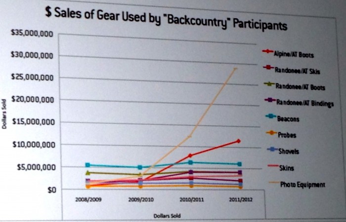
Graphic from a recent SIA study, presented at ISSW 2014 in Banff, AB.
This influx of technology has undoubtedly changed the way we operate in avalanche terrain.  Social media outlets such as Instagram is just kerosene on the already raging bonfire, especially among the 16-35 year old age bracket, statistically the age range which comprises a vast majority of avalanche fatalities across the globe. 65% of fatalities from 1951 to 2013 to be exact. Avalanche terrain + abundant powder + youth + bragging + proof of taking chances for said bragging = more close calls and ultimately, fatalities. Very little concrete GoPro-specific research has been done to date, but, if point of view (POV) videos of avalanche involvements are any gauge, the statistics may be staggering. Worth keeping in mind next time your standing on top of the primo slope asking your buddy if that little red light is blinking…
Courtesy Photo |
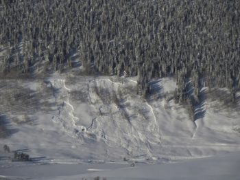
This is a photo of a shallow slab that propagated impressive distances on the December 13th facet layer, near Purple Palace. Photo credit: Aaron Huckstep |
Current Data
Surface:
http://weather.rap.ucar.edu/surface/
https://avalanche.state.co.us/obs_stns/stns.php
http://mesowest.utah.edu/cgi-bin/droman/mesomap.cgi?state=CO&rawsflag=3
Schofield SNOTEL: http://www.wcc.nrcs.usda.gov/nwcc/site?sitenum=737
Upper-air soundings:
http://weather.rap.ucar.edu/upper/
Radar & Satellite:
http://www.weathertap.com ($84/yr, great mobile website as well)
Discussions
NWS: http://www.nws.noaa.gov/view/prodsByState.php?state=CO&prodtype=discussion
OpenSnow: http://opensnow.com/dailysnow/colorado
CAIC: http://avalanche.state.co.us/forecasts/weather/zone-forecast/
http://wasatchweatherweenies.blogspot.com
Forecast Models: Twisterdata.com
Top Center
NAM = 84hr 12km resolution
GFS = 384hr 27km resolution
RAP = 18hr 13km resolution
Left Side
700mb = orographic wind direction
500mb = vorticity
300mb = jet stream
Upper Right
Clickable map = one forecast image
Animated loop = all forecast images
Compare models = toggle between each model
dProg/dt = see the trend in the forecasts
Forecast Models: CAIC
High-resolution version of the NAM model
Graphics: http://avalanche.state.co.us/forecasts/weather/model-forecasts/
Points: http://avalanche.state.co.us/forecasts/weather/point-forecasts/
Forecast Models: Weatherbell.com
Access to European model graphics and many other models. Fantastic data. $185/year
Zach Guy
Forecaster, CBAC
By now, you’ve probably noticed the CBAC has had a bit of a make-over. We have spent over a year designing, researching, redesigning, and coding our new website, which we launched this week. We were operating on an old dinosaur of a web platform and it was time for a new site that matched the current state of the e-world. This new site has improved graphics, higher resolution imagery, more user friendly from our end and yours, an improved observations platform, a format that is more consistent with avalanche centers nation-wide, and some additional forecasting tools which you can use to make safer decisions in the backcountry. Bear with us as we work through the kinks and strive to improve the functionality of the site.
Now let’s jump into a key element of our daily forecasts: the avalanche problem. The reason we put a lot of focus on avalanche problems is because the flavor of the avalanches we expect to encounter can be more influential in our terrain and risk management than a given danger rating. For example, not all Moderat danger ratings are created equal. I move through terrain and make snowpack assessments very differently for a Moderate danger when the only concern is wind slabs, versus a moderate danger involving deep persistent slabs. The Utah Avalanche Center just published a new tutorial on avalanche problems; its worth a look. http://utahavalanchecenter.org/avalanche-problems-tutorial. The CAIC also defines each problem here
This idea of avalanche problems is nothing new to our CBAC users, but we’re presenting it in a slightly different way. The four key elements to the avalanche problem is the avalanche character, its distribution, its likelihood, and its size. Here’s an example of how we present the problem. You can always click on the little blue “information” icons for more help or info.
The trickiest part of this is the distribution rose: where the problem is located across our terrain. Imagine a conical shaped peak, and you are hovering above it in your private helicopter. The inner-most rung is the highest elevation: above treeline, and the outer-most rung is the base of the cone below treeline. Each triangular octet represents a compass direction, so imagine this conical peak is oriented the same way it would look on a map. Now here’s the important part. We shade the areas where the problem is most likely. The problem distribution is never as black and white as it appears on this rose. This gives you general guidance on where you are most likely to encounter the problem at the regional level, but it is still up to you to make assessments on individual slopes. Here’s an example: We get a mild snow event with strong westerly winds. Our advisory will probably shade the distribution of fresh wind slabs on leeward aspects (NE, E, SE) near and above treeline because windslabs will be fairly widespread on those slopes. Given such an event, I can almost always find wind slabs on windward aspects (due West) too, if I seek out cross-loaded features or gullies. There might be a few slopes below treeline that develop wind slabs as well. So just because the wind slabs are prevalent on higher elevation, leeward aspects, it doesn’t mean you shut off your snow senses if you’re traveling elsewhere. We will try to describe these nuances and subtleties in our text, so its in your best interest to read the whole advisory and not just look at the pretty pictures.
The likelihood is fairly self explanatory. This is the chance of triggering a slide if you are recreating in steep, avalanche terrain in the parts of the rose that we have shaded, where the problem is most prevalent. Lastly, we describe the expected size. Small avalanches are D1’s: relatively harmless to people unless they push you into a terrain trap. Large avalanches are D2’s: they could bury, injure or kill a person. Very large avalanches are D3’s: these could bury cars, destroy a house, or break trees. Historic avalanches are nearing the maximum size a slope can produce. These don’t happen every year.
We’d like to acknowledge Brandon Clifford, our website designer, and the CAIC for contributing resources and forecasting elements. We hope you find our new website useful in planning and making safe decisions in the backcountry.