CBAC’s 2021/22 Annual Report is available for download here or in the PDF viewer below. The report relives a winter of feast or famine and highlights the outreach and operational accomplishments of the CBAC. We also recognize the many sponsors, donors, and partners who are critical to our mission. Thank you!
CBAC_AnnualReport_2021_22_2Observation contest winner!

CBAC featured in Backcountry Magazine
The CBAC is featured in this month’s Backcountry Magazine, in an article that highlights the history and current operations of our local avalanche center. You can read the issue here.
2020-21 CBAC Annual Report
Our annual report recaps the horrific snowpack last winter, and how CBAC combated the deadly winter through its operations and outreach efforts. The report also details our user analytics, finances, and outlines goals for next season. Huge thank you to all of our sponsors, donors, and partners who make our efforts possible.
New forecast platform
We have a few exciting changes to announce as we gear up for winter, including a new forecast platform and new forecast zones!
Forecast Platform
We are adopting the National Avalanche Center’s new forecast platform. The new platform has some great upgrades for our users to help us better communicate our safety messages to you.
- It’s mobile-friendly. More and more of our users are now accessing the forecast from their phones. The new forecast pages will now adjust to fit your phone or tablet, making it easier to read our forecasts on the go.
- Better media. We now have the ability to add photos, videos, and captions within portions of the forecast to help illustrate avalanche problems or travel advice more clearly to you.
- Bottom line and problem descriptions. While the basic layout of the forecast page will look similar to years past, this platform allows us to add a bottom line and problem descriptions. The bottom line will highlight the key points of the forecast, and the problem descriptions allow us to provide dynamic travel advice for each avalanche problem as conditions evolve.
- Conditions blog. We’re experimenting with a “Conditions Blog” tab that can accompany the forecasts. This is where we will provide weekly summaries and bonus material that supplements the forecast. More info for you at your fingertips!
- Consistency. There are about 8 or 9 other avalanche centers around the country that are adopting the same platform. If you go skiing or riding in the Sawtooths, or Cascades, or Sierras, or any number of other mountain regions around the West, you can expect to see avalanche information presented in the same format as ours. That makes it easier for you to digest the info and communicate with your partners.
New Forecast Zones

This map, which lives on our homepage, will show the daily avalanche danger rating for each of the two forecast zones. Clicking on a forecast zone will lead you straight to the forecast.
As most of our regular users know, the Crested Butte backcountry often develops into distinct snow climates: one with a deeper snowpack to the west and north of town, and one with a shallower snowpack near, east, and south of town. In the past, we often use the text to describe nuances between the snow-favored parts of the forecast area and the drier parts of the forecast area. Now, with our new forecast platform, we are integrating two forecast zones: the Northwest Mountains and Southeast Mountains. This change allows our forecasters to better highlight spatial differences in the avalanche danger, travel advice, or size and distribution of avalanche problems. We divided the zones based on our historical understanding of where the deeper and shallower snowpacks commonly develop. Our homepage has a map of the forecast zones to reference these boundaries. The Northwest Mountains include the snow belts of the Anthracite Range, Kebler Pass, Ruby Range, and Paradise Divide. The Southeast Mountains include the drier parts of our forecast area such as Cement Creek, Brush Creek, the Gothic area, and some terrain close to town such as Red Lady Bowl, Climax Chutes, Coneys, and Snodgrass. Our forecast team expects that there will be plenty of days where the forecasts for each zone will be exactly the same. However, there will also be days where we highlight important differences. For you, it’s simple. Click on the forecast map or select the forecast zone for the region that you plan to travel in for the day. That will lead you to the most current and relevant information. Our detailed forecast discussion will be the same across both forecast zones to simplify the material for those folks who enjoy following the progression of the snowpack on a daily basis. And as a reminder, these are regional forecasts that generalize conditions across a large area. Although they should serve as a starting point for planning your day, you are responsible for assessing conditions on a slope by slope basis to minimize your avalanche risk.
Feel free to shoot us a message if you have questions about any of these changes! cbavalanche@gmail.com
Zach Guy
CBAC Lead Forecaster
Welcome Ben Pritchett as the new ED and Lead forecaster for CBAC!
![]() |
Ben at the 2017 Grand Traverse |
A letter of protest to surface hoar
![]() |
Unusual cloud layers and unusually widespread surface hoar layer in mid January. Photo courtesy of MSF Films |
Then more snow came, and it formed a soft slab above you, and your behavior started getting erratic through the last week of January. We saw lots of natural avalanches, we saw avalanches breaking in dense aspen groves and on low angle slopes, and we saw slides remotely triggered from flat terrain.
![]() |
A slide on Mt. Emmons that caught a skier off guard. |
![]() |
Most of the persistent slab avalanche activity in late January was on surface hoar. Read this observation for some caveats to this diagram. |
The New Year storm….already historic and still counting!
![]() |
Credit: Xavier Fane |
![]() |
Credit: Chris Miller |
![]() |
Credit: Xavier Fane |
Back in the flow. Zach Guy, CBAC Director
The Western U.S. is coming out of a long drought and the atmospheric snow guns have finally replaced the artificial ones that were building our ski area’s snow base. With snow comes avalanches. There were two avalanche fatalities in the West over the weekend: a skier in closed terrain in Mt Rose Ski Tahoe on Saturday, and a backcountry skier near Cooke City, MT on Sunday. We send our sincere condolences to all of those affected by these tragedies. Here in Colorado, there has been a stroke of divine luck, with a number of multi-party burials that resulted in profound learning lessons, rather than fatalities. A trio of skiers in Butler Gulch, near Berthoud Pass, were all caught and buried on Saturday. Two of them were only partially buried and were able to rescue the third. On Sunday, a skier was caught in a slide near Red Mountain Pass and two snowmobilers were fully buried but rescued by their group near Steamboat. On Monday, a snowmobiler was buried near Crested Butte. Needless to say, avalanche season is upon us.
The search area for the avalanche victim at Mt. Rose Ski Tahoe. Photo courtesy of Washoe County Search and Rescue.
The Elk Mountains have been in a favorable zonal flow pattern since December 6th. CBMR reported 18” of snow in the past week, and some of our backcountry areas have picked up almost twice that. More is on the way this weekend. Anytime we have periods of dry weather, especially early season, our snowpack develops weak layers. Once we start getting back into the storm track, those weak layers get loaded and stressed, creating avalanche concerns. Sometimes these avalanches can act in surprising or unique ways, like being triggered from long distances away or from flat terrain. This video demonstrates the challenging nature of persistent slab avalanche problems, where there is a cohesive slab over a persistent weak layer.
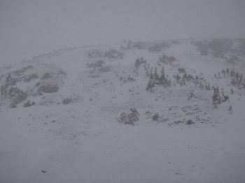
A group of 3 skiers were buried in this slide in Butler Gulch, CO on Saturday. Photo courtesy of CAIC.
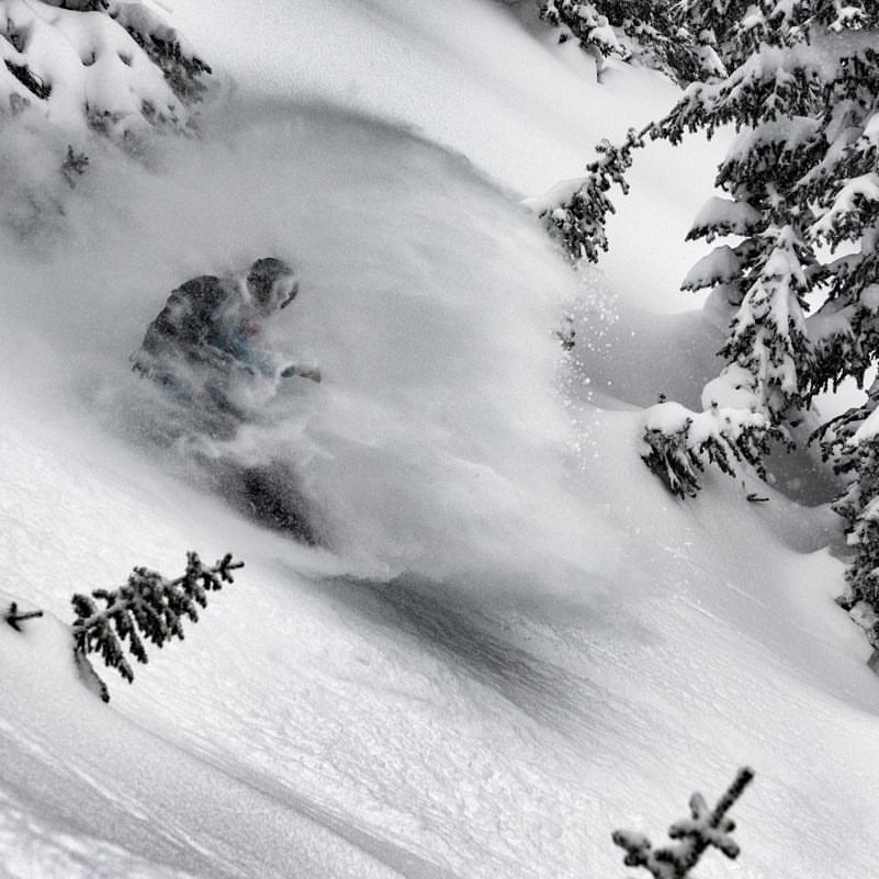
It is easy to get caught up in the powder frenzy this time of year. We’ve all been itching to arc those graceful turns down powder filled slopes or throttle through deep pillows and faceshots. But we need to draw a line and stay behind it. One of my mentors up in Montana recently discussed how taking one step back from the line is insufficient. “To ensure a lifetime in the mountains, it is a matter of taking three or four steps back.” The CBAC got an observation yesterday, reporting signs of instability, which concluded with: “Suspect a successful tour could have been had with proper navigation today, but the instabilities spooked us, especially while navigating unfamiliar terrain. We opted to head home.” I applaud that kind of decision making. There isn’t any kind of steep or deep powder run that exceeds the reward of returning home safe at the end of the day.
Snow profile showing unstable results near Crested Butte. 12/11/16
If you are new to the area or visiting, make sure you tune into our avalanche advisories at www.cbavalanchecenter.org. Our forecast team has been in frenzy the last couple weeks to keep tabs on the state of the snowpack. On Sunday, after a big pulse of moisture plowed through the night before, we had all three of our forecast staff up three prominent drainages surrounding our town digging into and documenting the snowpack to help aid in your backcountry decision making. Use our website and observations page as a resource! Give those guys a pat on the back for their often stressful and sleep deprived work during the holiday season. You can just sense the anxiety in Havlick’s voice in this video, and I bet the poor guy hasn’t done his laundry in 2 weeks now. And thank our ski patrollers at CBMR and respect roped off or closed terrain. Those guys and gals are working hard to mitigate avalanche hazards to get terrain open.
Thanksgiving and avalanches
Thanksgiving and avalanches. By Zach Guy
Shooting cracks are a sign that the snowpack might have taken a few too many scoops of mashed potatoes and stuffing.
It has been a wonderfully warm and dry fall, which is hard to complain about. But if we can be brutally honest with the weather gods, fall really was starting to wear out its welcome, and we are happy to open the door to winter. There’s nothing quite like surfing over powder, so it’s time to dust off those skis, find your beacon, shovel, and probe, and start tuning into our daily avalanche reports.
Early season skiing and riding comes with some challenges and risks. The snow coverage is still quite shallow, so striking rocks and logs are tough to avoid and they can end your season pretty quickly. My strategies include getting on the fattest skis I can find, riding like a gaper in the backseat, and using releasable bindings in case my tips dive under a log or rock. I’ve seen a few too many broken tib-fibs from early season riding. And of course, we all want to go to where the snowpack is deepest, which can open the doors to another scary threat: avalanches. This time of year, the slopes holding deep and continuous coverage often carry the greatest risk of triggering an avalanche. It is almost impossible to go through fall without a shallow, crusty, and faceting foundation forming on the ground. Then once we start building a deeper snowpack, it creates a persistent slab avalanche problem above these layers.
Skier triggered slides in Red Lady Bowl
I like analogies, so let’s compare our current year’s snowpack to your most recent Thanksgiving celebration. You probably avoided food all day, maybe even went for a turkey trot to work up an appetite in preparation for the big feast. A significant drought, indeed. That left you weak and frail, just like the lingering snowpack layers that survived our fall drought. Then once dinner time (i.e. winter time) rolled around, you started off at a decent pace. Snacked on some hor devoirs, some salad, maybe some of your Uncle’s famous deviled eggs or your Grandma’s bean dip. Our first few storms behaved in similar fashion, fairly small and steady loads, with a handful of isolated avalanches. Nothing too scary yet. Then it is dinner time: you go for the mash potatoes, stuffing, turkey, green bean casserole, and of course drown it all under gravy. Extra rolls? Why not? Whammo. That’s a heavy load, just like our last storm, which dumped almost 2 feet in places. Both scenarios are dangerous. You could collapse on the couch just as easily as you could collapse those fragile weak layers near the ground. During and after the storm, we saw both natural and skier triggered avalanches, some quite large and surprisingly wide. As of Tuesday night, I’m expecting we’ll see evidence of a lot more avalanche activity as we get better visibility over the next few days. So tread carefully out there, and check the avalanche report before you go out. So what’s next for our snowpack? Does it reach for another plateful of mashed potatoes before slamming down some pumpkin pie and faceplanting onto the floor? Or does it slowly nibble at the leftover turkey and try to stay awake for family charades? Only the weather can dictate that one. But you can be the captain of your risks by making rational decisions and practicing your rescue skills. Is it a coincidence that this Friday night is our Annual Avalanche Awareness Night, with the theme “Human Factors and Decision Making”? Or that Saturday is our annual Beacon Brushup, a free and valuable opportunity to dial in your rescue skills for the winter? I think not. See you there!