Storm slab in Red Lady Bowl

CB Avalanche Center2018-19 Observations

Location: Kebler Pass Area
Date of Observation: 01/08/2019
Name: Maxwell Lasky

Subject: Storm slab in Red Lady Bowl
Aspect: South East
Elevation: 11,500 ft

Avalanches:

What appears to be two separate naturally triggered storm slabs in Red Lady bowl. Worth noting that the debris ran very far down bowl down over the roll overs after the main pitch.

Weather:

Snowpack:
Photos:

Valley Avalanche Observations from 1/7 Storm

CB Avalanche Center2018-19 Observations

Location: Crested Butte Area
Date of Observation: 01/07/2019
Name: Ian Havlick

Subject: Valley Avalanche Observations from 1/7 Storm
Aspect: East, South East, South
Elevation: 9-12,000

Avalanches:

Here are avalanches observed over the last 24hrs as visibility has allowed on east to southeasterly facing terrain on Gibson Ridge and Whetstone. Seems that the near to below treeline areas may hold most recent evidence of natural avalanche cycle. Likely due to weakest snow prior to storm.

Weather: Clear, calm, cold.

Snowpack:
Photos:

Slide above condos

CB Avalanche Center2018-19 Observations

Location: Crested Butte Area
Date of Observation: 01/08/201

Subject: Slide above condos
Aspect: South East

Photos:

CB Avalanche Center2018-19 Observations

Location: Crested Butte Area
Date of Observation: 01/08/2019
Name:

Subject: “sunlight” ridge avalanche
Aspect: North East
Elevation: 9500

Avalanches:

Sunlight ridge above avalanche fence. Slid right at sunrise. Maybe 300′. Most likely a wind slab from last nights wind event. Observed from plow

Weather: Sunny, clear skies, 5 degrees

Snowpack:

Photos:

Irwin Cat Ski Obs

CB Avalanche Center2018-19 Observations

Location: Kebler Pass Area
Date of Observation: 01/08/2019
Name: Irwin Guides

Subject: Irwin Cat Ski Obs
Aspect:
Elevation:

Avalanches:

Shallow Storm slabs running on on the 1/6 interface up to D1.5. Flaming Ferrari and Whisky shot produced soft slabs up to D1.5 in size. SS-ASc-R1-D1.5

Weather: Overcast, Snowing S1 all day with strong South Westerly winds all day.

Snowpack: Wind blown snow surfaces stiffening in the last 24 hours. The storm slabs are running on the 1/6 interface and entraining a fair bit of snow. The snow safety team noted that the storm slabs were eroding through the 1/6 interface in the cocktail shots.

Photos:

Sensitive Storm Snow

CB Avalanche Center2018-19 Observations

Location: Crested Butte Area
Date of Observation: 01/07/2019
Name: Eric Murrow

Subject: Sensitive Storm Snow
Aspect: North, North East, East
Elevation: 9,600 – 11,142

Avalanches:

Viewed what appeared to be numerous shallow human triggered D1’s from yesterday that had refilled with about 5inches overnight. Was able to skier trigger several small pieces of start zones that were not impacted by travellers yesterday.
I had zero visibility outside the small bits of terrain I was above and certainly could not see any other avalanche activity on adjacent mountains.

Weather: During the course of my walkabout snowfall rates varied between S-1 and S1. With around 2 inches of accumulation from 1100 to 315. On the uptrack winds were very light even in wide open terrain. Large tall trees near ridge top were holding lots of storm snow until around 145pm but during descent around 230 winds began to pick up at this location and snow started being blown out of trees. Open terrain near parking lot was actively drifting at 315.

Snowpack: I measured HST at 11,000′ and found about 14.5 inches with 1.15 SWE. While walking in flat terrain I was able to produce small shooting cracks up to a ski length. Walking along steep northeasterly facing terrain at 11,000′ I was easily and predictably able to trigger small D1 Storm Slabs on terrain steeper than 35 degrees however there was lots and lots of skier traffic yesterday during the first half of storm which cut up most of the start zones and/or released small slabs. But every piece of steep unmolested snow I was able to touch released or slumped. All of this activity was in a thin layer of weak low-density storm snow a cm or two above old snow even though a few locations had small surface hoar present at the old interface – go figure.  The bottom half of the slab was fist+ in hardness. There was no real evidence of wind effect that I could see, but the ridge top is well forested.
While exiting the area I found a slope that was more easterly, less north, that had a bit of open terrain above it and found a drifted start zone about 20″ deep. I made a fast ski cut conservatively just short of the slope and produced a shooting crack about 30 feet but the slope failed to release.

Photos:

Snodgrass-GFP

CB Avalanche Center2018-19 Observations

Location: Crested Butte Area
Date of Observation: 01/07/2019
Name: ADB

Subject: Snodgrass-GFP
Aspect: East, South East
Elevation: BTL

Avalanches:

Weather: Obstructed skies, light wind, S2 snowfall

Snowpack: last 48 hours: 10 to 16 inches of new snow.

with equipment-weight of skier is 121 lbs.
off skin tracks, continuous and consistent cracking isolated to area surrounding the skin track; collapsing to a depth of 16 inches.

Disclaimer: highly qualitative tests. cuts were made with ski poles.
Hand tests:
East aspect in aspens: CT3 Q2 with failure on buried surface hoar (?) 8 inches below surface.
SE Aspect in the trees: CTN Q2 on melt freeze crust 8 inches below the surface
West Aspect on road cut uphill of weather station: CTN Q1/Q2 on melt freeze crust 16 inches below the surface.

Photos:

CBMR avalanche activity

CB Avalanche Center2018-19 Observations

Location: Crested Butte Area
Date of Observation: 01/07/2019
Name: CBPSP

Subject: CBMR avalanche activity
Aspect: North, North East, North West
Elevation: 10,800′-11,500′

Avalanches:

Teocalli Bowl
NE aspect NTL several AE-SS-R1-D1-I avalanches where the storm slab was initiated by explosives and storm slabs on adjacent paths ran sympathetic.
N aspect NTL AS-SS-R4-D1.5-I

Big Hole
ASr-SS-R3-D2-O/G Triggered from 10′ away while approaching the slope.

Weather: Temperatures in the teens with moderate gusty winds from the west. Storm total 9″ at 7 % and still snowing S2.

Snowpack: The avalanche observations are from two different zones Teocalli bowl which has seen previous avalanche mitigation work and, and boot packing throughout the season so far. On N facing terrain in Teo NTL before the storm the HS was on avg. 60 cm’s of weak faceted snow as the aspect tilted East the HS was around 40 cm’s with a 10cm surface crust on top of weak faceted snow. The 2nd observation is from Big Hole BTL NW aspect which is an area that has been unaffected by any patrol traffic all season. This entire pitch did run natural 1 month prior on facets at the ground and has since filled in with 60 cm’s of weak snow that has also become weak and faceted since then.
Photos:

Storm Slabs on SW to W

CB Avalanche Center2018-19 Observations

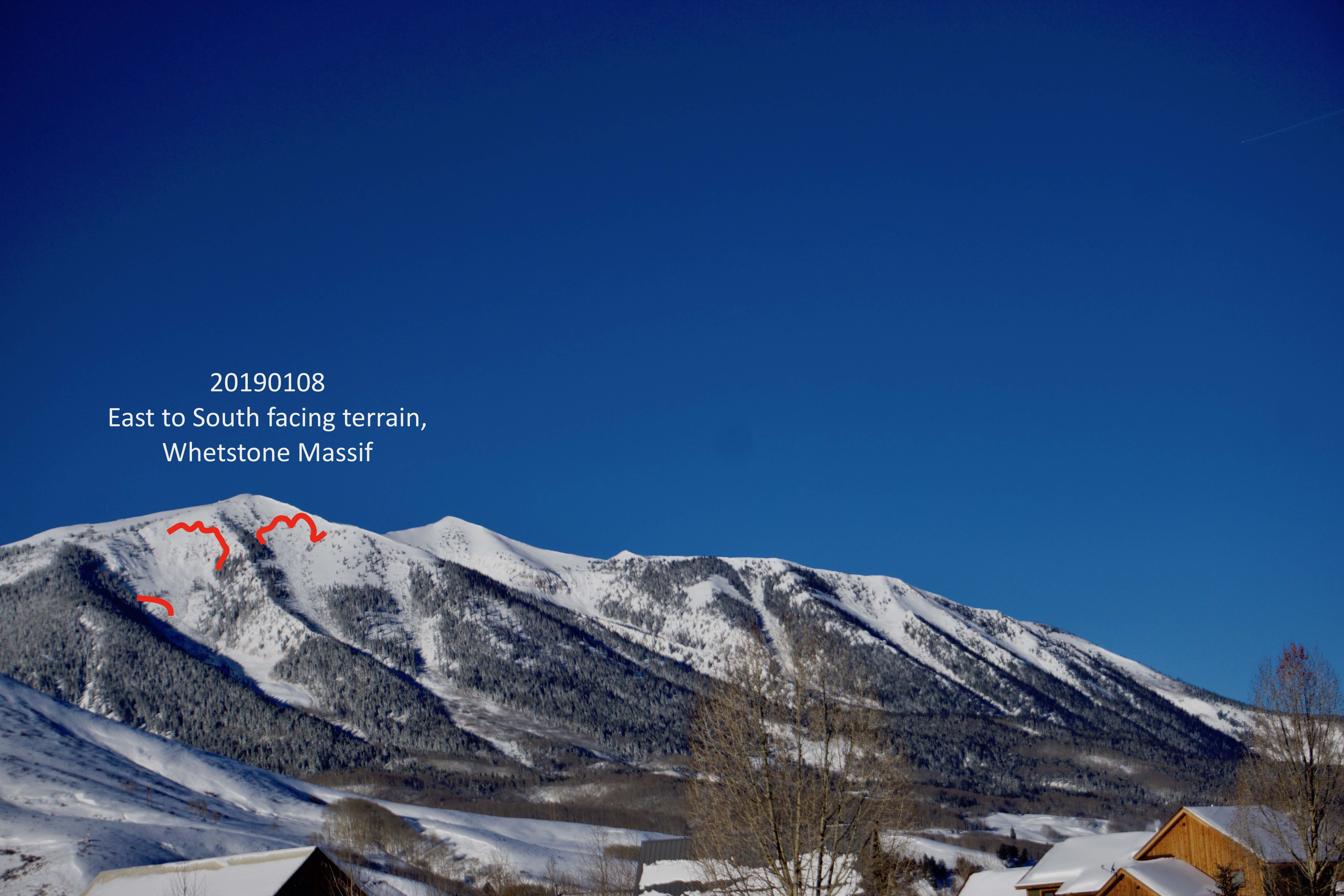
Location: Paradise Divide Area
Date of Observation: 01/07/2019
Name: Evan Ross

Subject: Storm Slabs on SW to W
Aspect: South East, South West, West
Elevation: 9,500-10,300

Avalanches:

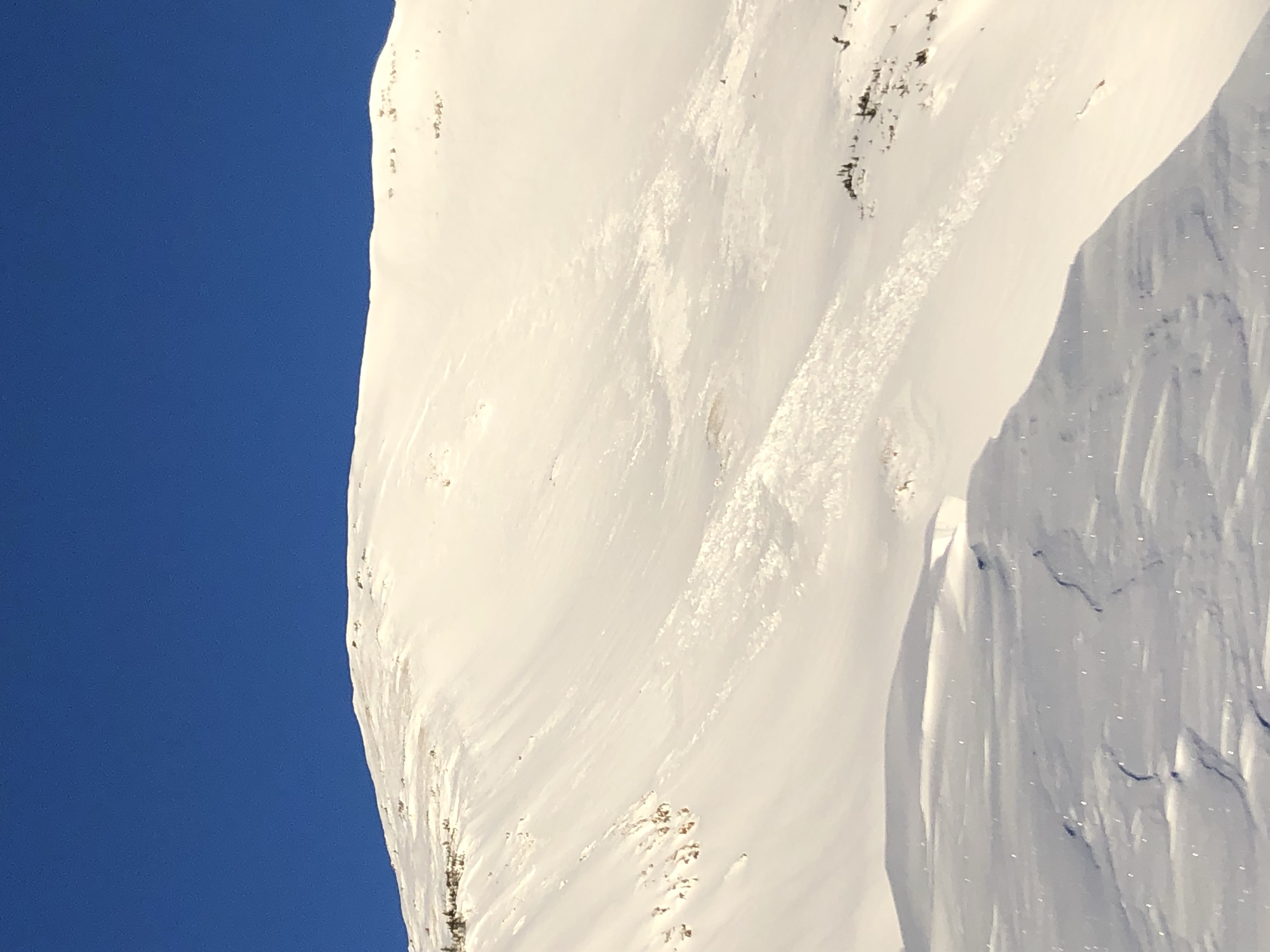
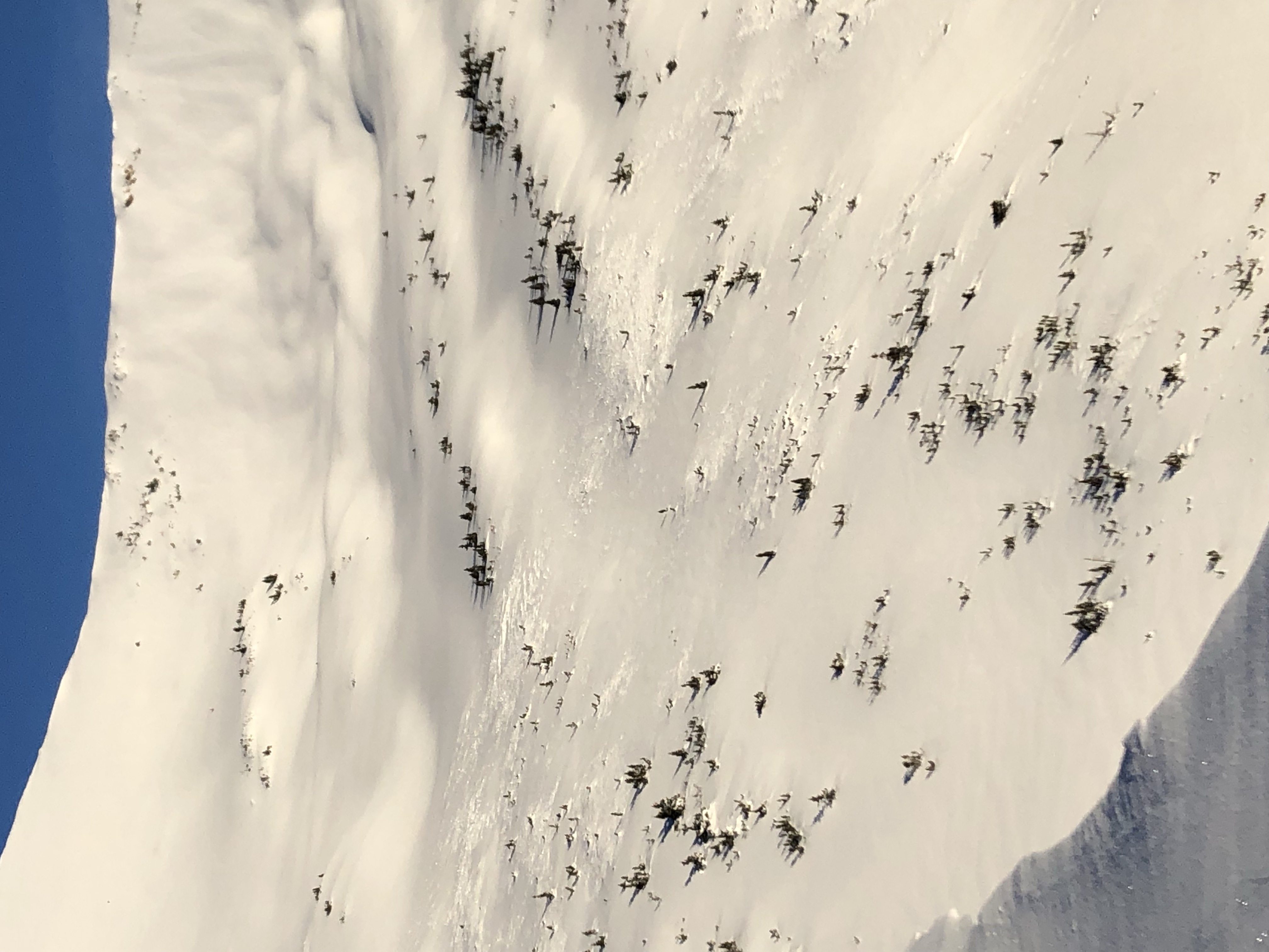
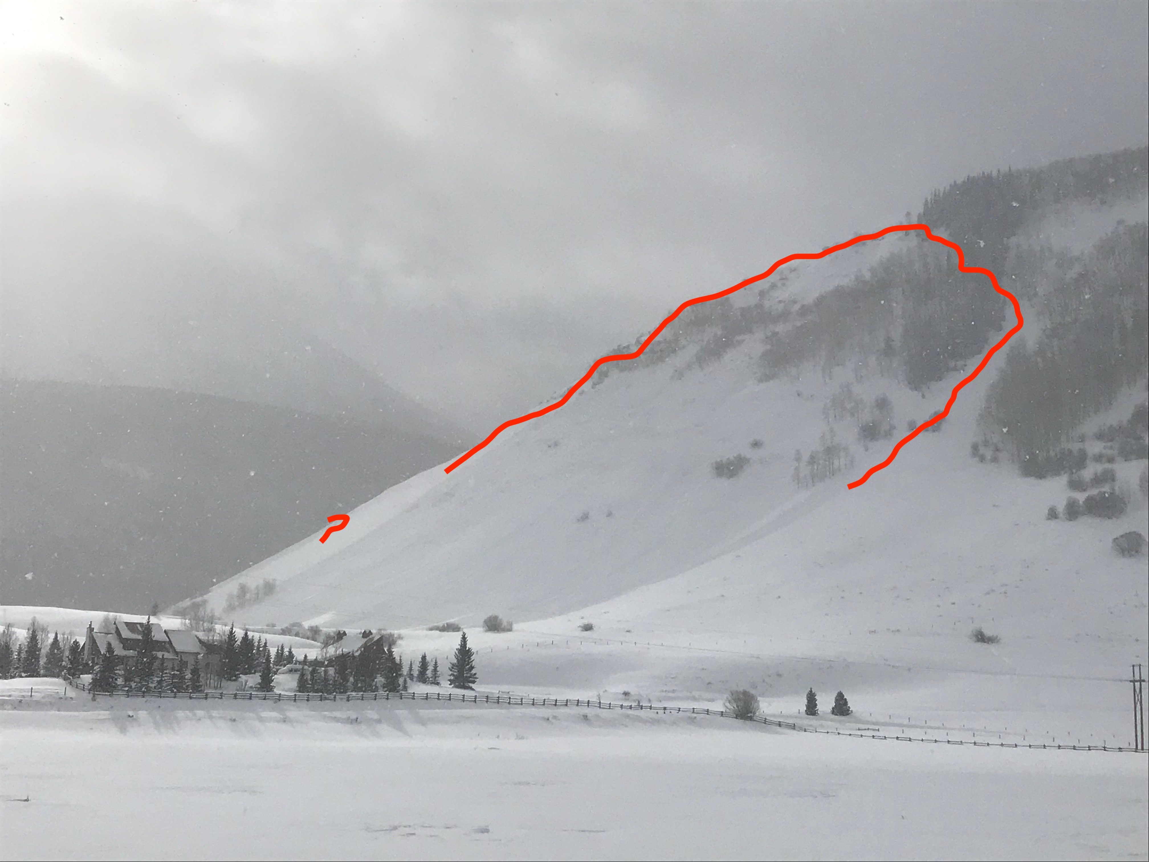
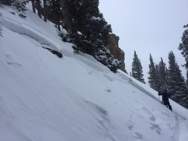
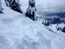
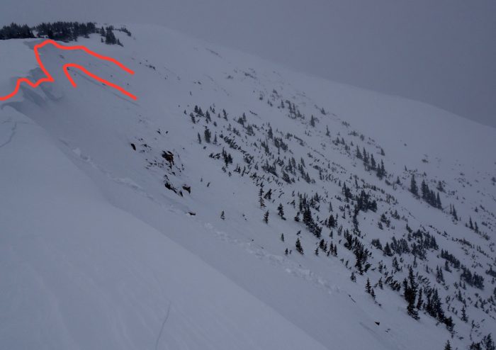
Several human triggered Storm Slabs. Mostly remote triggers. Small in size with 1 D2 on a bigger slope.

3# SS-AS-R1-D1-S. SW to W
1# SS-ASr-R2-D2-S/O. West
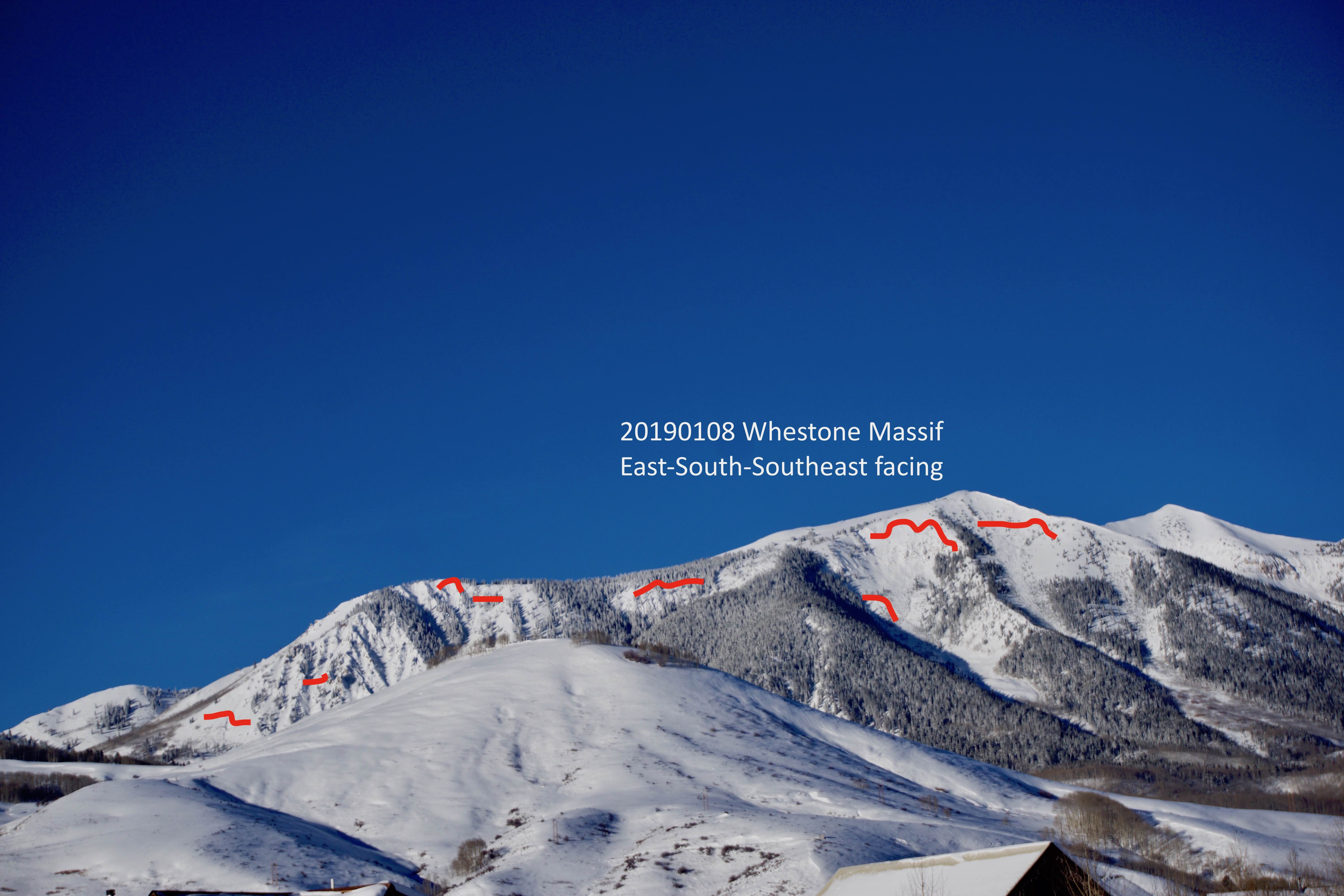
2# D2 to 2.5 natural avalanches out the NE facing Climax chutes. Poor visibility, could only see debris.

Weather: Headed out after noon. Obscured sky and snowing S1 for most of the afternoon. We were not observing much for wind, but the wind was certainly blowing slow above our elevations and on the way back home in open valleys.

Snowpack: Several muffled, but far traveling collapses on the 1/6 thin crust. However avalanches were failing about 5cm above the crust within the recent storm snow. That bottom 5cm of the storm snow was very soft and full of stellars. Spent a long time looking at these to make sure it wasn’t a layer of SH. HST wast about 16 to 18″ in this area at 3pm.

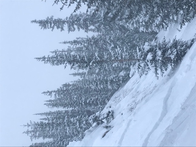
Shooting cracks down to the storm instability on many slopes there were not steep enough to avalanche.

Photos:


Red Coon Storm Day

CB Avalanche Center2018-19 Observations

Location: Crested Butte Area
Date of Observation: 01/06/2019
Name: Eric Murrow

Subject: Red Coon Storm Day
Aspect: North, North East, South East, South
Elevation: 9,300′ – 11,600′

Avalanches:  While at ridgetop near treeline stomping around the edge of a N – NE facing drifted slope was able to trigger two avalanches. The first was N facing that only involved storm snow, fairly thin at only 6″ deep, D1. The second was higher up at a location that receives efficient drifting that was up to 14″ deep, small portion in center stepped down another 8 or 10″. See the pictures below.

Weather: Snowfall rates were generally s1 with periods of s2 before 1pm. Winds were light at valley bottom in the morning with a gradual increase during ascent to moderate at treeline. Transport and fresh cornice formation observed.

Snowpack: When new snow reached about 6 inches very minor cracking started to appear, very slight Storm Slab formation in top two or three inches of storm snow on southerly slopes near and below treeline. At ridge top found drifts up to 18 inches deep. At 11,600′ @ about 2pm HST reached 8.5″ with .55SWE.

Photos: