Fredo’s Apron

CB Avalanche Center2018-19 Observations

Location: Crested Butte Area
Date of Observation: 01/10/2019
Name: CBPSP

Subject: Fredo’s Apron
Aspect: North
Elevation: 11,150′

Avalanches:

CBMR 11,150′ N aspect cross loaded feature from SE winds below large cliff band. AE-SS-R1-D2-O. Propagated 175′

Weather: Increasing high clouds throughout the day high temp of 34 with calm winds.

Snowpack: HS 43 with approx. two inches of settlement today. In sheltered areas snow weak and faceted with specific ares of wind stiffened snow. Previously unaffected area from skier traffic or explosives.

Photos:

No hate from the Slate

CB Avalanche Center2018-19 Observations

Location: Paradise Divide Area
Date of Observation: 01/10/2019
Name: Roscoe

Subject: No hate from the Slate
Aspect: North East
Elevation: 11,400

Avalanches:

There were signs of Avalanche activity on the lower slopes and rollovers , similar to what what was posted in an OB yesterday . Not much on the upper slopes .

Weather: Grey Bird Day calm and warm

Snowpack: In the zone we were in the slopes were not terribly affected by wind. Snow was dense and supportive. I did not seem this area received as much snow on the last cycle as the Kebler Pass Corridor.

Photos:

Check in on Coney’s skier triggered avalanche

CB Avalanche Center2018-19 Observations

Location: Crested Butte Area
Date of Observation: 01/10/2019
Name: Evan Ross And Eric Murrow

Subject: Check in on Coney’s skier triggered avalanche
Aspect: North East, East
Elevation: 9,800 to 10,800ft

Avalanches:

SS-ASr-R1-D2-O. 1/9

Weather: Calm winds. Partly cloudy sky and warm feeling temps

Snowpack: HS in the 100-120 range on average. Ski pen around 20cm and SH on much of the snow surface. A few large collapses in the terrain but no shooting cracks.

The 1/9 remote triggered avalanche failed just below the holiday slab on 1.5mm NSF. This layer of NSF was about 5cm thick. Crown hight Varied between 1 to 4 feet thick. The thicker part of the slab was on a wind-loaded terrain feature. Slope angles on the bed surface were in the 34 to 36 range. East facing aspect at 10,360ft.

Photos:


Quick Gothic Townsite Tour

CB Avalanche Center2018-19 Observations

Location: Paradise Divide Area
Date of Observation: 01/09/2019
Name: Zach Kinler

Subject: Quick Gothic Townsite Tour
Aspect: East, South East
Elevation: 9,600

Avalanches:

No Gully Washers but many D1-D2+ avalanches Below, Near and Above Tree line on Gothic’s East side including 1 that ran during the tour. See pictures.

Weather: Sunscreen re-application day, calm winds, temps warming above freezing.

Snowpack: Generally ~ 30cm new snow, surface remaining dry in the shade and becoming wet in the sun.
Photos:

Numerous Remote Triggered Avalanches

CB Avalanche Center2018-19 Observations

Location: Brush Creek Area
Date of Observation: 01/09/2019
Name: Evan Ross

Subject: Fun With Avalanches
Aspect: North, North East, East
Elevation: 9,500-10,800

Avalanches:

Ooo boy. This is going to be long.

The highlights: One bounce, producing a collapse, that remote triggered 1 x D2, 1 x D1.5, and slumped the snow off a another rock outcrop. Two other separate collapse each remote triggered a D2 and separate D1 at the same time. The furthest point from a human triggered collapse to the furthest point of a crown, measured on google earth, was about 2,200ft. Yea baby.

2 x SS-ASr-R1-D2-O, NE, BTL
1 x SS-ASr-R1-D2-O, E, BTL
4 x SS-ASr-R1-D1.5-O, NE, BTL

1 x SS-N-R1-D1.5-I, South, ATL. Fresh Natural today. Steep rocky terrain.

There were many more natural avalanches to D2.5 in size from the 1/6 cycle. Mainly on N to E facing aspects at BTL elevations. Other aspects and elevations had a few old Persistent Slabs, but most avalanches looked to have failed within the storm snow and were often confined to gully features or wind-loaded terrain. 

Weather: High clouds hung around for much of the day. Calm wind. Warm temps.

Snowpack: The holiday slab is the slab… while the January 6th storm just added the load to tip the balance. The 1/6 storm snow was about 10 to 12″ in sheltered terrain at the elevations traveled. The 1/6 snow was very soft on NE and becoming moist on E, and other sunny slopes. The very weak NSF below the holiday slab was the layer of concern. This layer was failing in collapses and triggered avalanches, and those avalanches were either running at the interface or gouging to the ground. Boot pen to hip and ski pen about 25cm. HS in the 100-120cm range.

Collapses that produced human triggered avalanches were very very quiet and subtle. No shooting cracks where ever observed from the same area I got a collapses that remote triggered and avalanche. After a collapses, it was a long 10sec before remote triggered avalanches started running.

Photos:

Remote on north end of Coney’s

CB Avalanche Center2018-19 Observations

Location: Paradise Divide Area
Date of Observation: 01/09/2019
Name: Kyote

Subject: Remote on north end of Coney’s
Aspect: East
Elevation: 11,500

Avalanches:

Remote trigger on a southeast steep slope on the north end of Coney’s. Crown was up to 3-4 ft in wind loaded area. Occurred on the new snow from this week. There weren’t any signs of instability prior to seeing this avalanche.

No cracking, romping, etc

Weather: Clear and really nice.

Snowpack: Fresh 1 foot of snow
Photos:

Snodgrass-GFP after the storm

CB Avalanche Center2018-19 Observations

Location: Crested Butte Area
Date of Observation: 01/09/2019
Name: ADB

Subject: Snodgrass-GFP after the storm
Aspect: East, South West, West
Elevation: BTL

Avalanches:

Weather: Calm, few clouds, and warming temperatures above freezing. Warm in the sun.

Snowpack: 1 cm surface hoar widespread in open areas with no shading.

Disclaimer again: Very qualitative tests with hands and poles.
Off main skin track and filled in skin track, no collapsing and one shooting crack.

SW Aspect- hand test CT 13 Q3 on crust 12 inches below snow surface
W Aspect uphill of the weather station CT 4 Q3 on crust 12 inches below snow surface.
Photos:

Natural activity and stiffening slabs

CB Avalanche Center2018-19 Observations

Location: Crested Butte Area
Date of Observation: 01/08/2019
Name: Eric Murrow

Subject: Natural activity and stiffening slabs
Aspect: North East, East
Elevation: 9,600-10,800

Avalanches:

Peeler Peak ATL ENE R1-D1.5
Rock Creek Drainage (Treasury/Galena area) 2x ATL SSE R1 – D1.5 plus additional debris pile off NE slope with crown not visible
Slopes above Peanut lake road – NE BTL R2 – D1.5 – camera died when viewed at end of day but I think there were two

Weather: very nice day with mild temps and calm winds

Snowpack: Travelled on NE and E terrain below treeline. Storm snow was about 35 to 40cm and was 4f- hard. Most places I looked a layer of soft preserved stellars was present at bottom of storm snow. Test results on this layer in a slightly drifted spot were CT11 and ECTN11. While crossing open portion of ridge top, I was able to get a few moderate rolling collapses by jumping, and a few short running cracks but no results. These locations with collapses were drifted 2+ feet. Ski cut the margins of two drifted areas at ridge top without results. Riding conditions were supportive and surfy very different from 24 hours prior.

Photos:

Explosive triggered avalanches on the 1/6 interface

CB Avalanche Center2018-19 Observations

Location: Kebler Pass Area
Date of Observation: 01/08/2019
Name: Irwin Cat Operation

Subject: Explosive triggered avalanches on the 1/6 interface
Aspect:
Elevation:

Avalanches:

Along with the noted avalanches we got small pockets to pull out of Candys and Sonic. Both running on the 1/6 interface as well. The sonic debris was much needed to fill in the massive wind whales below the choke.
NC Shooter SS-AE-R2-D2.5-I MF-01/06 (35cm x 25m x 250m)
Thin Line SS-AE-R1-D2-I MF-01/06 (20cm x 20m x 80m)

Weather: Warm with high temps of 34 down low and 24 up high. Few clouds off and on today with swirling winds calming down to single digits gusting to 8.

PM Weather

Sky

Sfc

MxTp

MnTp

Temp

WDir

WSpd

Gust

Time

H2D/W/DEN

HN24

HST/W

HS

Study Plot

FEW

DF

36

8

34

191

3

5

0800

0.0/0.00 0.0

4.0

16.0/1.80

50.0

Scarp Ridge

Solar: 3

25

12

24

60

1

3

1600

0.0/0.00 0.0

0.0

0.0/1.80

50.0

Snowpack: Party Hats Left had a progressively stiffening (4f-1f) 30cm slab that felt hollow while probing around that was noticed full path. The avalanches in EBM are running on the 1/6 MFcr. East and south snow surfaces were moist by 1400.

Photos:

Night and Day difference in 24hr

CB Avalanche Center2018-19 Observations

Location: Paradise Divide Area
Date of Observation: 01/08/2019
Name: Evan Ross

Subject: Night and Day difference in 24hr
Aspect: North East, East, South, South West
Elevation: 9,400-11,500

Avalanches:

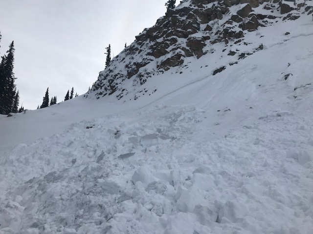
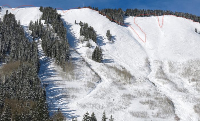
Baldy 1x Natural, ATL S, R1-D2
Baldy 1x Natural, ATL SE, R1-D2

Gothic Mountain 1x natural, SW ATL R2-D2.5
Gothic Mountain 2x natural, SW ATL R2-D2

Augusta Mountain 1x natural, ATL SE R1-D2. (Estimated from a far distance).
Mineral Point Natural 1x natural, ATL E R1-D2 (Estimated from a far distance).

Mt Emmons 1x Natural, ATL SE R2-D2

Long Lake area 1x Natural, BTL NE R3-D2

Long Lake area 2x Natural, BTL NE R2-D2


Weather: Few clouds and light winds. No blowing snow observed. Sun was warming the snow surface on southerly facing slopes.

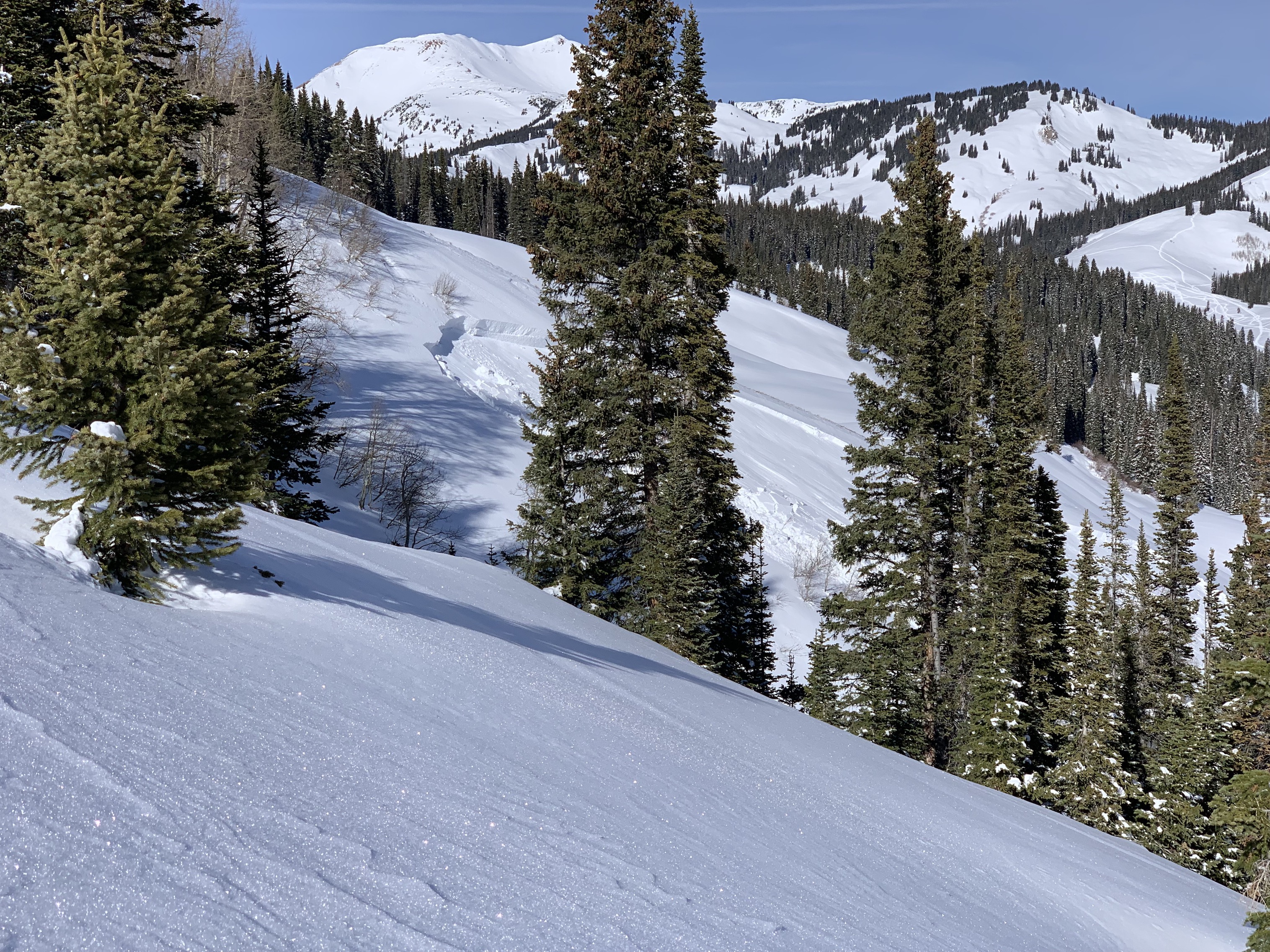
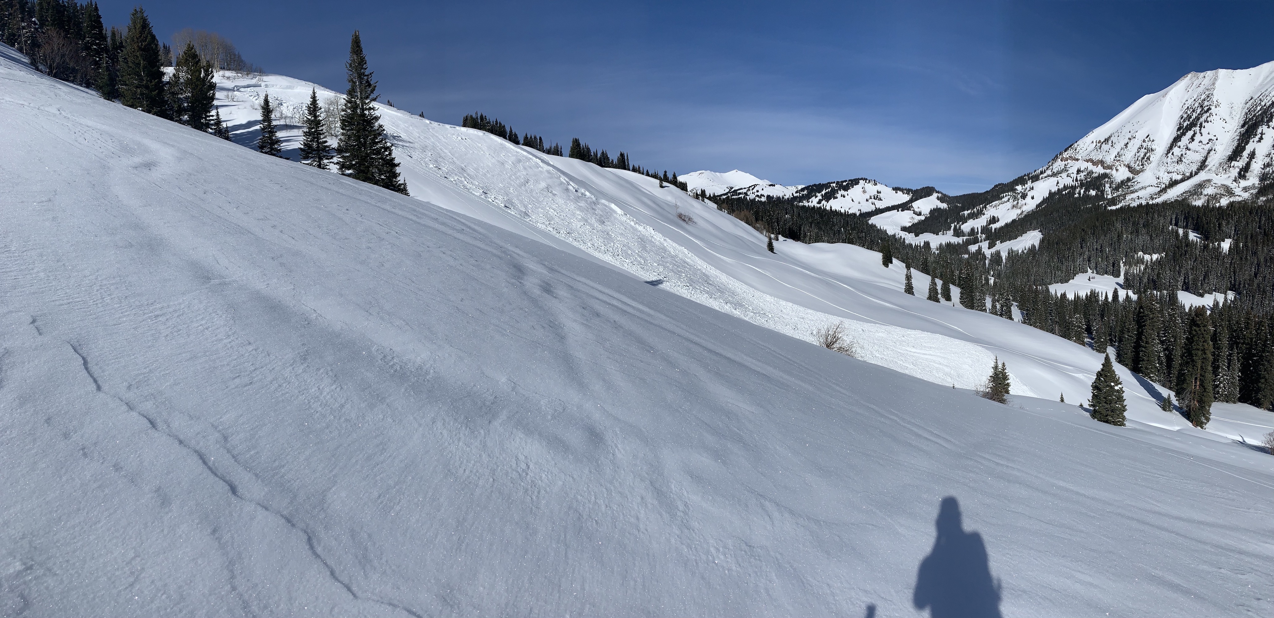
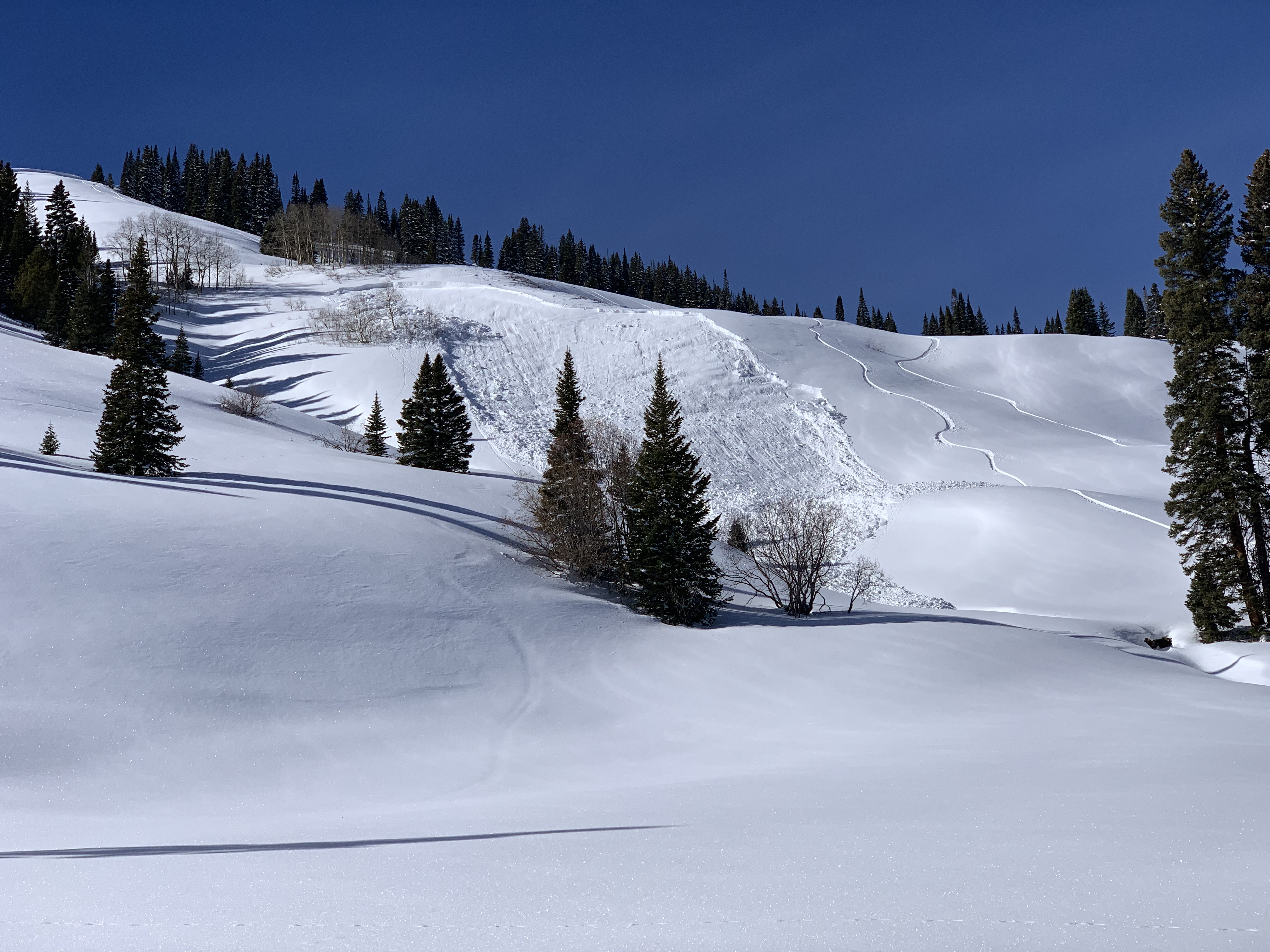
Snowpack: Night and day difference since yesterday. Yesterday I found shooting cracks everywhere failing in the storm snow, today on a lot of different slopes and some of the same slopes I only saw maybe two small slopes that produced some shooting cracks. These still appeared to have failed at the storm snow instability. Slice, diced, ripped and teared many slopes with very few sings to instability. These slopes where on many aspects, some wind-loaded, some not, but all generally small in size. Given the depth of the new slab, the compressive support of this size of slope may have played a role.

At 11,000ft storm accumulations were about 45cm. This slab was 4F at its base in sheltered areas. ATL SW facing slopes where the most blown out looking. Though there was still a number of crowns on that aspect. SE and W aspects had some great examples of cross-loading to give you pause. Other lee aspects were definitely looking thick and loaded. The weak layers under this slab already look difficult to effect from the weight of a skier, but the avalanche size wouldn’t be something you want to get caught up in.

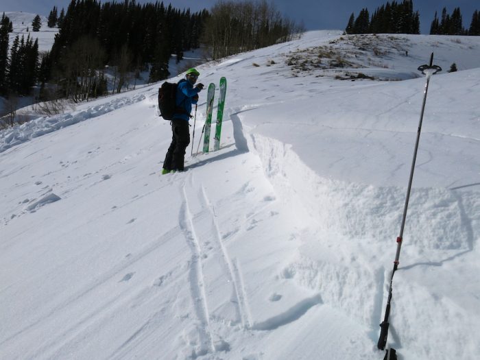
SE at 11,200ft. 30 degree slope with a vertical HS of 145cm. ECTN M results at the storm instability, ECTP result on +30 taps below the Santa Slab on 1mm rounding facets above the crust.

Photos:

Â