Skier triggered slide- Baldy

CB Avalanche Center2018-19 Observations

Location: Paradise Divide Area
Date of Observation: 01/30/2019
Name: Eric Murrow

Subject: Skier triggered slide- Baldy
Aspect: South
Elevation: 11,000′ – 12,500′

Avalanches:

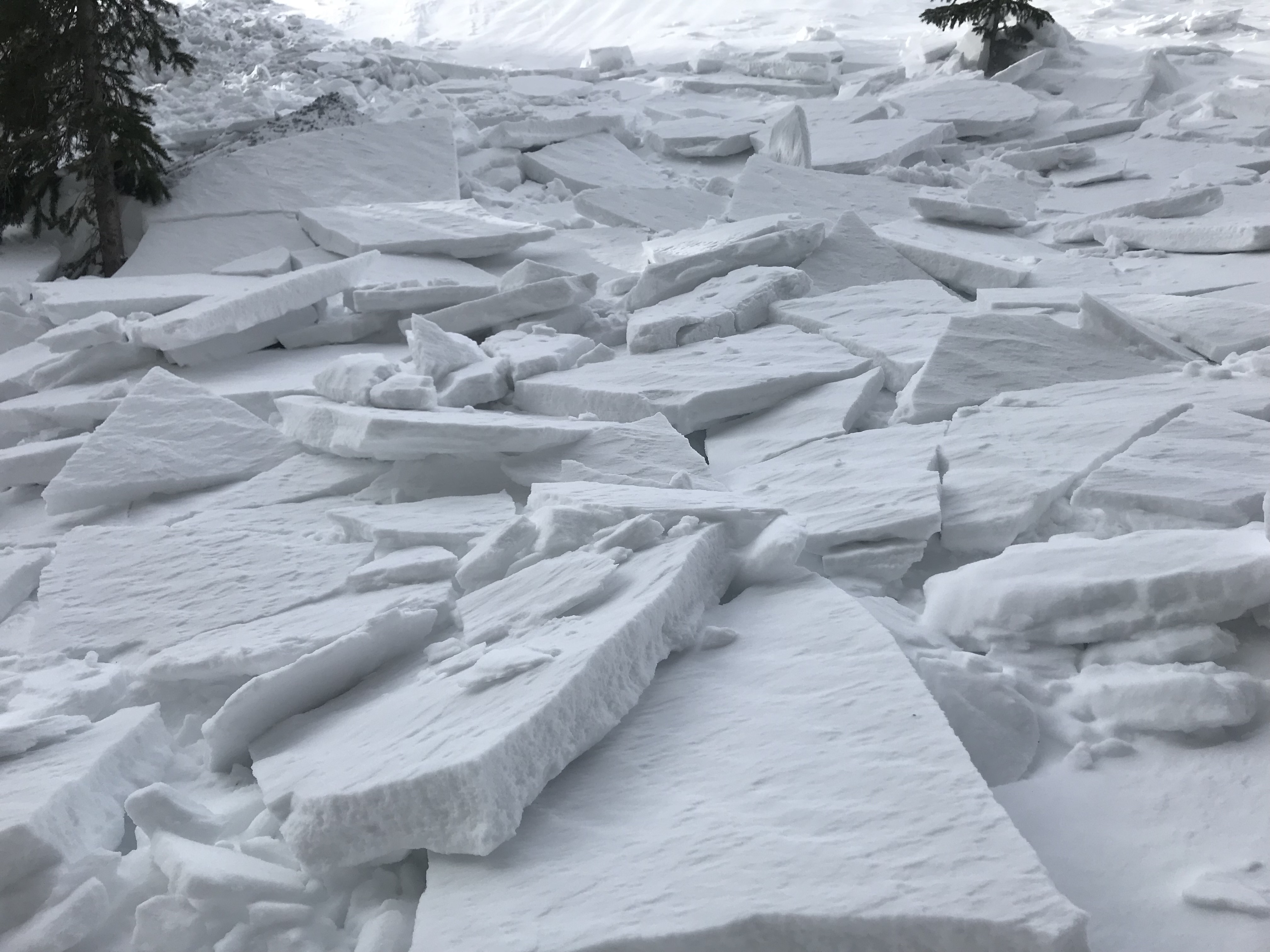
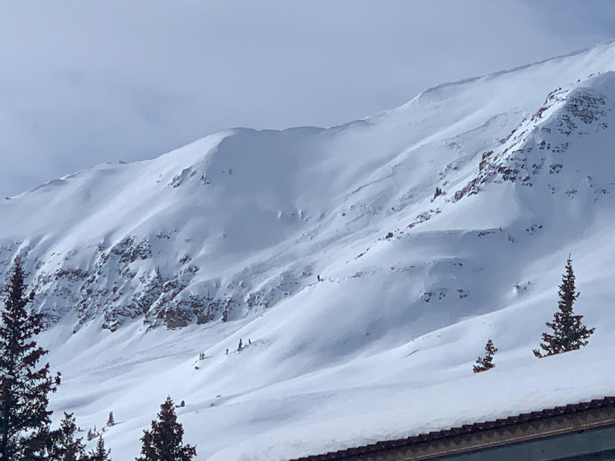
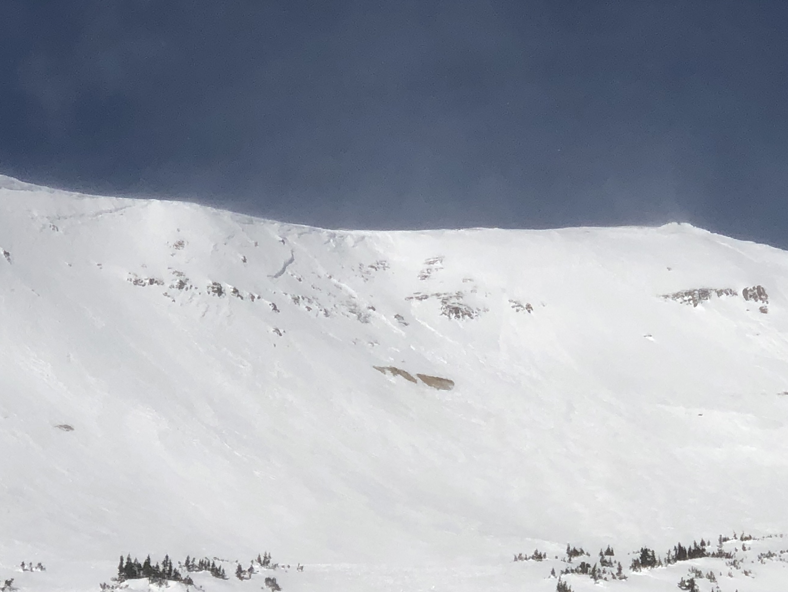
Skier triggered avalanche on Mount Baldy south bowl. It was triggered midslope; skier caught and carried into the basin. Skier deployed airbag and was not fully buried and was not injured. Crown estimated to be 1 to 2 feet thick.

Weather: Bluebird, light winds

Photos:

Westerly terrain on the east side

CB Avalanche Center2018-19 Observations

Location: Brush Creek Area
Date of Observation: 01/29/2019
Name: Eric Murrow & Zack Kinler

Subject: Westerly terrain on the east side
Aspect: South, South West, West
Elevation: 9,000′ – 11,800′

Avalanches:

Nothing fresh observed.

Weather: Day started out with lots of high clouds and ugly flat light for snowmo trail breaking through weak, garbage snowpack, but as the day progressed clear skies prevailed with partly cloudy conditions. Winds were generally light, no transport observed. Temps were cold in the morning at valley bottom, but quite comfortable near treeline in the afternoon.

Snowpack: We moved through BTL and NTL on mostly S – W facing slopes. HS below treeline was around 60 to 90cm. As we climbed higher to treeline HS ran from about 100 to 130cm. Our objective was to target NTL SW and W slopes looking for Persistent Slab structure.
The first site was a SW facing slope at 11,400′. Here snowpack across a large area ranged from 100 – 120cm. We poked a hole and found that the 1/16 & 1/18 storm left a cohesive slab resting on a poor looking SH/crust/facet/crust sandwich. Test results produced ECTP 27 result above the 1/15 suncrust on SH. This is not the first place near treeline on a sunny aspect we have found buried SH. The PWL crap stack was down 45cm. Take a look at the photo below to see the test profile.
We also targeted a W facing slope just a bit higher at 11,600′. HS ran from 120 to 140cm across this terrain. Here we found snowpack that harboured the persistent weak layers from mid-January. Two layers of SH with a thin layer of facets between, 45cm down-again this structure is widespread across the CBAC forecast area on W-N-E facing slopes near and below treeline. The mid-December weak layer was obvious and still weak. ECTP 21 at the 12/19 interface. See photo below
Looking into the shady side of the ridge towards Teo and West Brush Creek, the couple of avalanche paths we peered into had run sometime early during the 1/16 & 1/18 storm events. Crowns were refilled but just barely visible, debris piles were visible on the valley floor below.
West facing above and near treeline terrain in upper Brush Creek and Upper Cement Creek looked shallow and blown out. See photos below.

Photos:

Ski Patrol Avalanche Mitigation- Fredo’s

CB Avalanche Center2018-19 Observations

Location: Crested Butte Area
Date of Observation: 01/28/2019
Name: Eric

Subject: Ski Patrol Avalanche Mitigation- Fredo’s
Aspect: North West
Elevation: 11,360′

Avalanches:

We have had numerous passes over the last several weeks in this piece of terrain with explosives work and ski cuts and had success affecting weak layers in the snowpack with these methods. We placed a 4# Air Blast on the far skiers right apron of Fredo’s and was able to affect the stubborn wind slab. The avalanche would be classified as HS-AE-D1-I.

Weather: Clear skies with strong winds from the NW and intense snow transport.

Snowpack: Witnessed evidence of wind affected slopes and stubborn wind slab. Any snow that had deposited in this piece of terrain from our previous storm seemed to have stiffened with the change in wind direction from the W-SW to the NW. The surface of the snow showed severe ripple marks and was extremely firm traveling across it on skis. It was fairly evident that the wind slab we were focusing on was stubborn and the likelihood of triggering would be low unless we used explosives.
Photos:

Irwin Cat Ski Obs

CB Avalanche Center2018-19 Observations

Location: Kebler Pass Area
Date of Observation: 01/28/2019
Name: IG

Subject: Irwin Cat Ski Obs
Aspect:
Elevation:

Avalanches:

Double on a stick popped windslab in Mikes pocket. 2 layers in the slab which formed Saturday and maybe late yesterday(?). OL Glade SS-AB-R2-D1-I U-01/26 (30cm x 20m x 80m) 2 windslabs pasted lee of tree fence

Weather: S1 with periods of S2 till 13:00. Then clearing SCT to FEW

Snowpack: Windslabs throughout our tenure. Some cracking with skis but no movement. Solid windboard up high in the UWW. Entrance to Sunset Left OL glade very stiff but supportable. Hollow feeling on
the actual windslabs which are obvious.
Photos:

Quick look BTL on west end of Emmons

CB Avalanche Center2018-19 Observations

Location: Kebler Pass Area
Date of Observation: 01/28/2019
Name: Eric Murrow

Subject: Quick look BTL on west end of Emmons
Aspect: East, South East, South
Elevation: 9,200′ – 10,500′

Avalanches:

Weather: Snow S1 with short periods of S2 during AM. Skies began became partly cloud by 2pm and snow tapered off, about 2.5inches new at 2pm.

Snowpack: Took a look at some easterly terrain near several natural avalanches that failed 1/25 or 1/126. HS at 10,400′ in rolling easterly terrain averaged around 160cm. On one East facing roll the early January weak layers were around 75cm down (was able to pick some rounding SH out of the interface), ECTX. This was likely the interface responsible for the nearby natural avalanches. Mid-December weak layer and early season basal weak layers continue to gain strength and round. Interfaces of interest in this deeper snowpack part of the forecast area are becoming the 1/15 and 1/21.

Photos:

Irwin Cat Ski Obs

CB Avalanche Center2018-19 Observations

Location: Kebler Pass Area
Date of Observation: 01/27/2019
Name: IG

Subject: Irwin Cat Ski Obs
Aspect:
Elevation:

Avalanches:

None today in our Tenure. Natural off Ruby from yesterday or day before. see photo

Weather: BRK Skies turned to FEW by the end of the day with moderate solar radiation and some green
housing through thin clouds. Winds were calmer today than yesterday.

Snowpack: South got moist today as well lower elevation SW. Good quality skiing all day with no signs of instability. We have not been skiing the UWW and LEAN was the highest we got in the Westwall.

Photos:

Snow Profile on Ponytail Glades

CB Avalanche Center2018-19 Observations

Location: Kebler Pass Area
Date of Observation: 01/27/2019
Name: Travis Tucker

Subject: Snow Profile on Ponytail Glades
Aspect: South
Elevation: 11,530’

Avalanches:

Red Lady Bowl Ridge @ 12,200’ @ time unknown
C-CN-R1/D1.5-I
SZ Ridge / Terminus TR
.5x15x45m
Cornice dropped on windslab

Weather: FEW clouds
27*F
Light winds from the NW-W with stronger gusts

Snowpack: 27* Test slope
Photos:

AIARE 1 tours in Washington Gulch

CB Avalanche Center2018-19 Observations

Location: Crested Butte Area
Date of Observation: 01/27/2019
Name: Casey Graham

Subject: AIARE 1 tours in Washington Gulch
Aspect: North East, East, South East
Elevation: 10, 800

Avalanches:

Peak west of Painter boy mine, E face on the south end of the ridge. PS, R1 D2~300ft. crown, ran ~300ft, E facing slope.

Weather: Mod. W winds, Broken sky, no precip., cold temps most of the day with a high of -2degC

Snowpack: Coney’s Crews – Avalanche observed above TL on peak west of painter boy mine. PS size 2 ~300ft. crown, ran ~300ft, E facing slope. Wind loading observed on NE aspects BTL

Pit dug near Ridgeline in Coney’s – 10,800PS found over early season facets. NE aspect, near tree-line, 26 deg. slope angle, HS-138, layer of concern: buried facets down 75cm. CTN x2

Snodgrass: Pit dug ESE, 10,800ft, 12 deg slope angle, HS 115, CTN x2 ECTX
Photos:

Snodgrass-End of the Melt down

CB Avalanche Center2018-19 Observations

Location: Crested Butte Area
Date of Observation: 01/27/2019
Name: ADB

Subject: Snodgrass-End of the Melt down
Aspect: East, South East
Elevation: BTL

Avalanches:

Weather: Obstructed skies and calm.

Snowpack: Trees: supportive and stiff in the trees. Open areas near the Gothic road have developed patchy sun crusts.
No signs of instabilities observed.
In thick dense trees, watch out for hollow shallow snow around saplings, as I caught a tip on three saplings; fell sideways with face buried in snow for 5 seconds before clearing air path. Had to pop out of two Dynafit bindings. A quick adrenaline rush.
Photos:

Windslab Sensitivity in Evan’s Basin and Red Lady Glades

CB Avalanche Center2018-19 Observations

Location: Kebler Pass Area
Date of Observation: 01/26/2019
Name: James Bivens

Subject: Windslab Sensitivity in Evan’s Basin and Red Lady Glades
Aspect: South East, South, South West
Elevation:

Avalanches:

The top eastern face of Evan’s basin had a few older looking avalanches. Lower down, we observed a D2 avalanche on the eastern aspect of Evan’s Basin below treeline that appeared to have been remotely triggered by sleds. We didn’t see the party and the slope appeared to have been heavily wind-loaded. We also observed another similarly sized avalanche lower down on the same eastern aspect; this one appeared to have ran naturally after wind-loading. We also noticed some reactivity on the final (steeper) pitch before the road when we triggered a little windslab.

Weather: Sunny and super windy above treeline and moderately windy below treeline (even down to Kebler Pass where we received some helpful pushes from the wind while skating back to the trailhead). Further north and west there appeared to be a mix of more wind and lower hanging clouds (for example, we could not see Mt. Owen clearly from the summit of Red Lady).

Snowpack: The snowpack felt supportive with no collapses or shooting cracks (except for the little windslab below.) The skiing was lovely in dense, soft snow, but there were patches of snow in direct sunlight at lower elevations that were starting to heat up (before potentially refreezing into crusts tonight).
Photos: