PM avalanche observation

CB Avalanche Center2017-18 Observations

Location: Brush Creek Area
Date of Observation: 03/23/2018
Name: Ben Pritchett

Subject: PM avalanche observation
Aspect: North East
Elevation: Above Treeline

Avalanches:

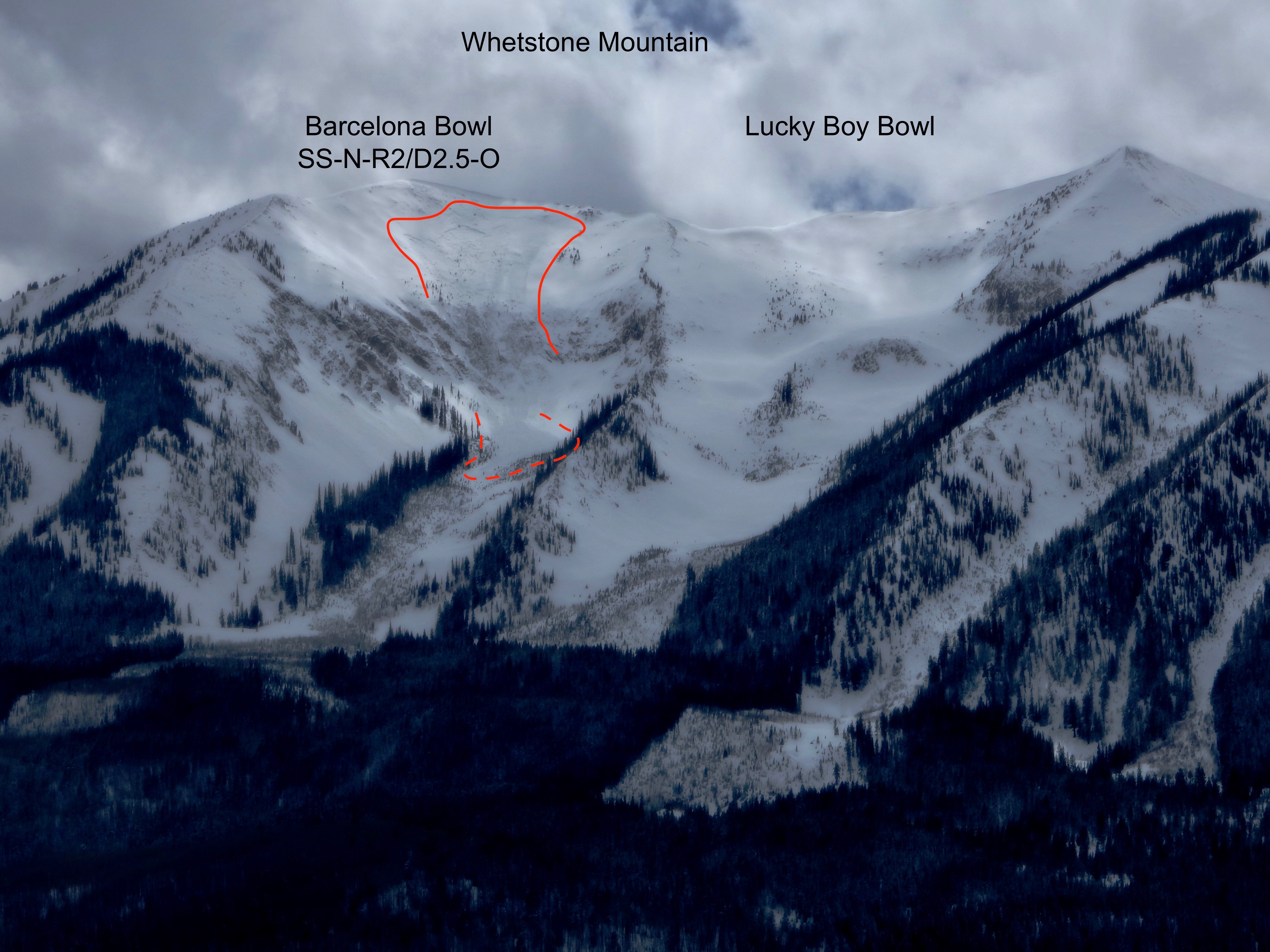
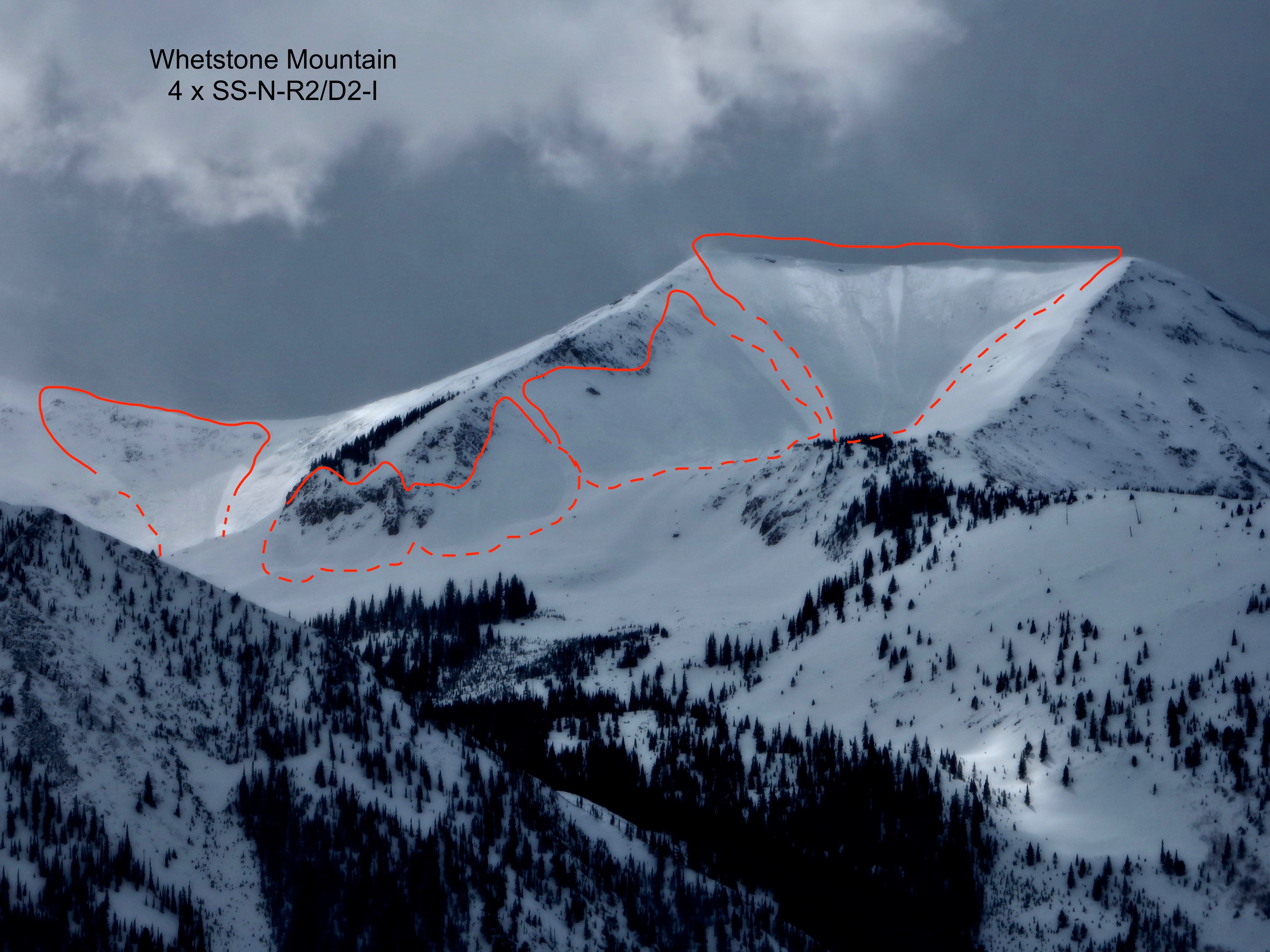
5x on Whetstone, 3x reported off Crystal’s North Face.

Weather: Snowed all day in the Alpine. >S5 precipitation in numerous pulses. Big pulse around 11, another around 1 (frontal passage) then numerous convective cells throughout the afternoon. Report from Star Pass included <10′ visibility all day, with only a few breaks minutes long. Strong winds transporting significant snow.
Snowpack: Wet snowpack down low. Rain saturated snowpack below treeline with a 12+ hour deluge, dropping something in excess of .5″ of liquid precip. Storm slabs in the alpine with storm totals topping 20″ near Taylor Pass. Over 2″ SWE observed at Schofield. PM winds drifted snow continuously. Taylor Pass reported no cracking in the snow. Star Pass was unable to test the new snow as visibility didn’t allow forecasters to find the cornice lip, though they did report 3 fresh avalanches.

Photos:

Baldy Drifting

CB Avalanche Center2017-18 Observations

Location: Paradise Divide Area
Date of Observation: 03/20/2018
Name: Ben Pritchett

Subject: Baldy Continued Drifting
Aspect: North East, East, South East
Elevation: Near and Above Treeline

Avalanches:

none observed

Weather: Steady light gusting to moderate winds from the West. High temps in the mid 20’s. High thin overcast skies.
Snowpack: Recent drifts observed 1 to 3 feet thick. Cracking was localized to areas where the drifts were 1-finger hard or stiffer. Near treeline the drifts were quiet and soft, only becoming denser / stiffer and able to crack above treeline.

Slate River storm snow

CB Avalanche Center2017-18 Observations

Location: Paradise Divide Area
Date of Observation: 03/19/2018
Name: Eric Murrow

Subject: Slate River storm snow
Aspect: North, North East, East
Elevation: 8900′ – 10400′

Avalanches:

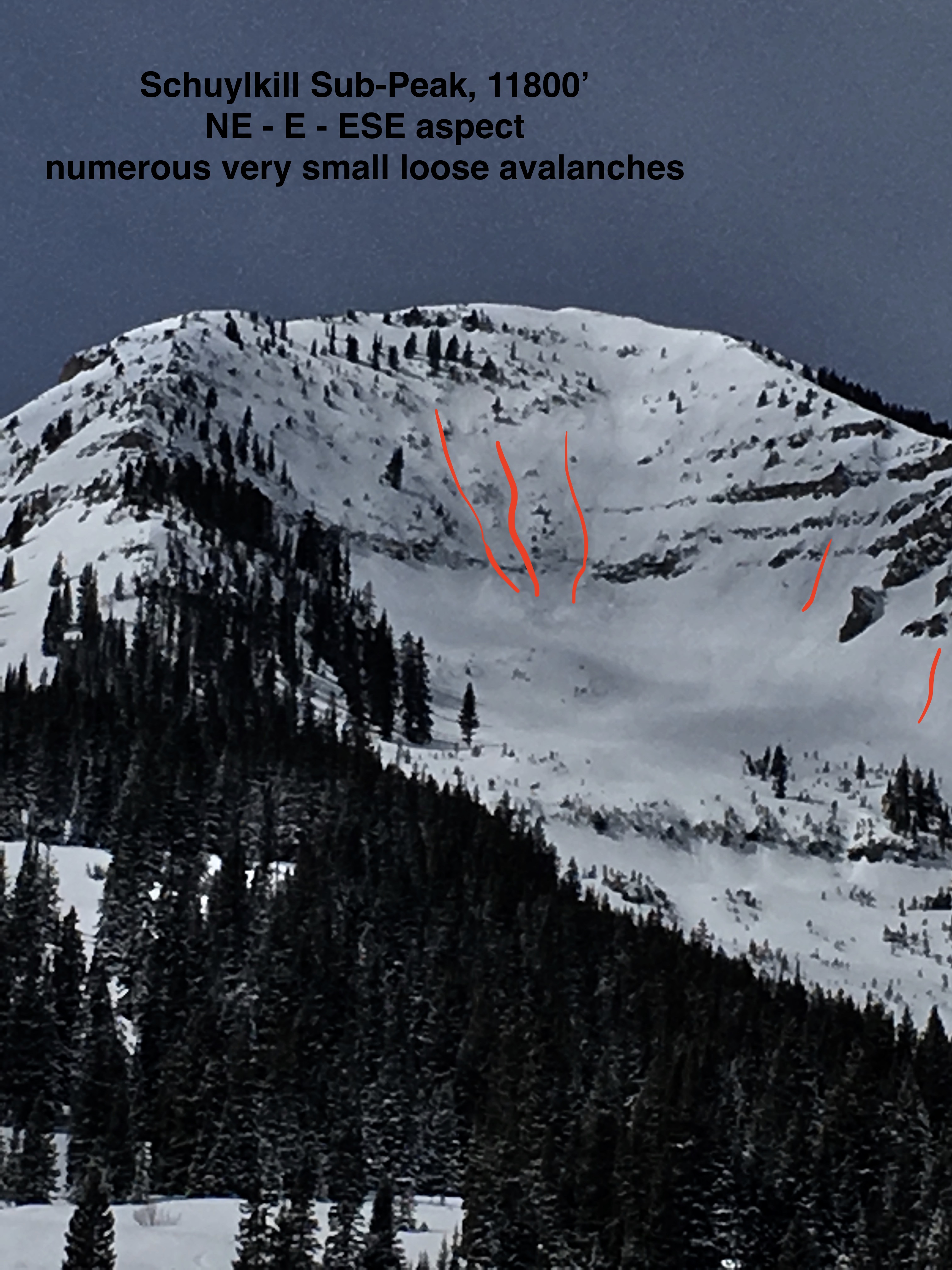
Many skiers and boarders out testing steep near and below treeline terrain on northerly slopes. Few very small skier triggered loose sloughs of little consequence, and one skier triggered, D2, storm slab avalanche on Schuylkill Ridge (documented in earlier ob). Numerous very small natural loose avalanches in new snow coming out of steep rocky cliff areas near and above treeline.

Weather: Partly cloudy skies with thicker cloud cover moving over the spine of Ruby Range. Light winds at below treeline elevations, vis of above treeline terrain was in and out, but observed no snow transport.
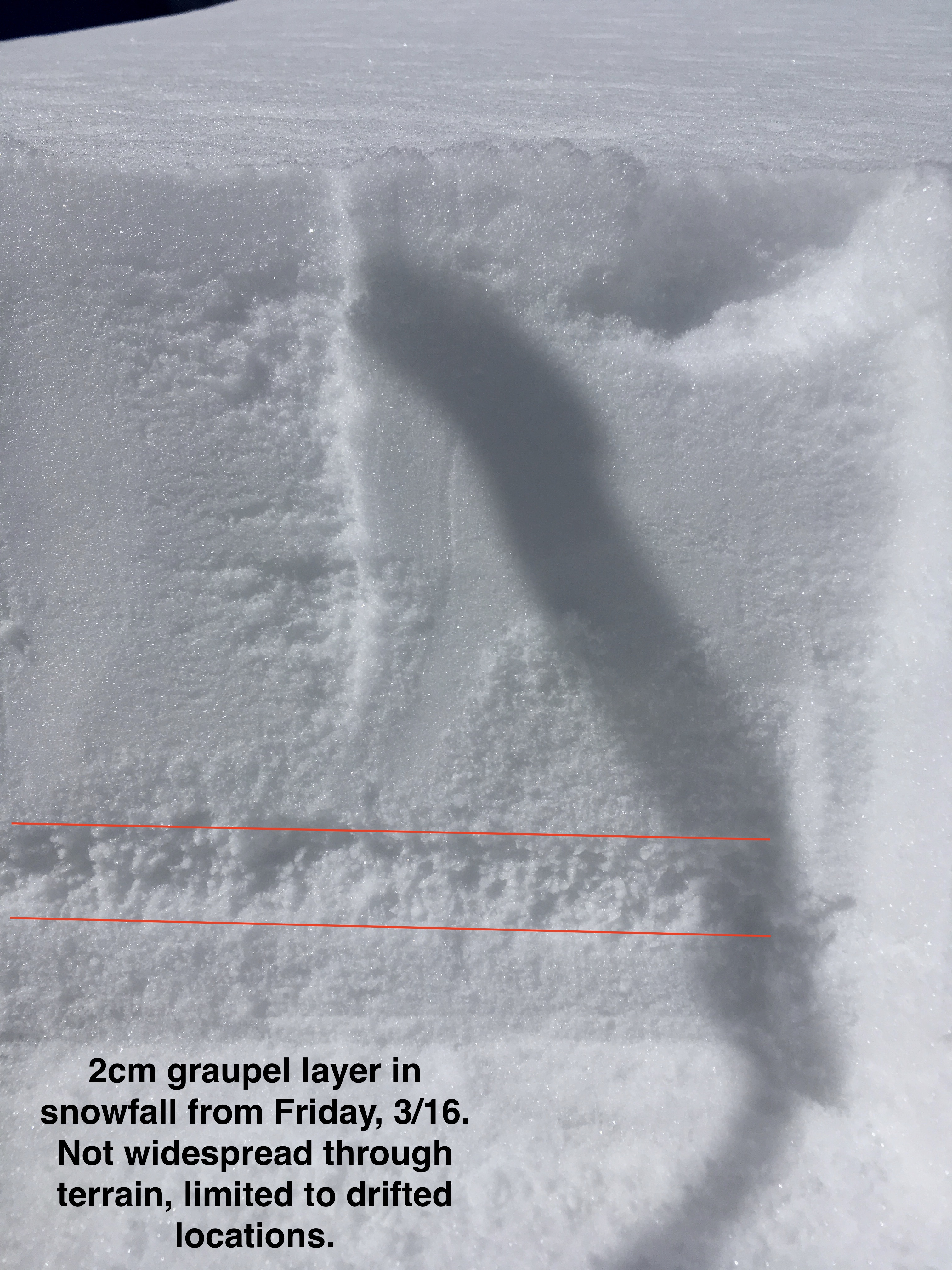
Snowpack: New snow accumulations were 3″ at Slate river TH and increased up 5″ at 10400′. Small isolated drifts below treeline were up to 9″ deep, but no cracking was observed. Terrain that faced NW – NE had dry snow underneath new snow but NE – E had 1-3cm sun crust below new snow (faceting was apparent below the crust, and could be a problem if a significant load is deposited in near future). Also of note – found graupel layer in drifted areas from Friday’s storm(3/16), CT’s produced moderate results on the graupel but no slab present above just low-density storm snow. Graupel layer was not widespread throughout below treeline northerlies limited to terrain features that were drifted after Friday’s storm on terrain features that were slightly tilted to the east.

Photos:

Schuylkill skier triggered slide

CB Avalanche Center2017-18 Observations

Location: Crested Butte Area
Date of Observation: 03/19/2018
Name: CBAC

Subject: Schuylkill skier triggered slide
Aspect: East
Elevation: 11,200′

Avalanches:

Skier triggered slide spotted from the valley. SS-AS-R1/D2-I.  Triggering party said “Ran on sun crust. Soft and ran like slough”.

Photos:

Remote trigger in Red Well

CB Avalanche Center2017-18 Observations

Location: Crested Butte Area
Date of Observation: 03/16/2018
Name: Dave

Subject: Remote trigger in Red Well
Aspect: North, North West
Elevation: 12, 300

Avalanches:

We skied a lap in red lady bowl, then went back up and dropped into red well. Remotely triggered a slide from the bottom on red well, 1st skier triggered the slide. It was a R1, D2.

Weather: Overcast in the Am cleared to sunny
Snowpack: New snow 3-5 in of new snow. Was deeper in loaded areas we skied. Did not see signs of instability of during tour.

Photos:

Crown roughly 24 of 4-finger drifted new snow.

Remote triggered from the furthest looker’s right point.

Fresh avalanche in Red Well, 2/16/2018.

Snodgrass

CB Avalanche Center2017-18 Observations

Location: Crested Butte Area
Date of Observation: 03/16/2018
Name: ADB

Subject: Snodgrass
Aspect: East, South East
Elevation: BTL

Avalanches:

Starting zone on slope greater than 30 degrees, cause loose slough (4 inches deep) which picked up more snow for about 300 feet. Snow piled up enough to bury one’s dog or knock you off balance.
On a a slope between 25 and 30 degrees, started another loose slough, which didn’t have the slope and energy to travel more than 25 feet.


Weather: Mixed weather: S-1/obscured skies/clear skies
light breeze

Snowpack: Between two to four inches of new snow on sun crusts in last 24 hours.

Photos:

Coney’s

CB Avalanche Center2017-18 Observations

Location: Crested Butte Area
Date of Observation: 03/15/2018
Name: Ben Pritchett

Subject: Coney’s
Aspect: North East, East
Elevation: 9-10,900 K

Weather: Convective showers all day, adding up to 2-3″ of snow by 3pm. Very greenhouse feeling, w/ intense radiation between the bursts of snow. Light southerly winds.
Snowpack: Dense rimed snow fell on wet snow surfaces. Very good bond between the saturated surface and the new snow initially, though it’s worth checking for “dry snow over melt layer” faceting at that interface in the near future as that interface freezes. Boot penetration was 10-20cm outside of very shallow isothermal areas. The melt water of the last couple days has changed the BTL snow surfaces to a very dense and consolidated cap over the old weak snow.


Snodgrass N-NE Ski tour

CB Avalanche Center2017-18 Observations

Location: Crested Butte Area
Date of Observation: 03/15/2018
Name: Chris Martin

Subject: Snodgrass N-NE Ski tour
Aspect: North, North East
Elevation: 9400′-1100′

Avalanches:

NO

Weather: WEATHER: Snow S-1,2,3 and BKN sky fluctuating back and forth throughout the day. Trend continued all the way ‘till 1600 when we exited the field. Virtually no winds except for around 1500 down valley winds.
Snowpack: Snowpack/Avalanche OBS:
Whump observed on flats touring up WG to Snodgrass, localized cracking only around skis. W aspect. No Slab Structure present. @ 10,000’ where whump occurred.

HS varied from 60-120cm. Persistent slab structure is present on the northerly aspects on Snodgrass, decreasing slab thickness as the aspect tilted more easterly. A few deep hand pits showed moderate to hard results failing above a stout MFcr @ 40 cm down on a NE aspect. On a N aspect, similar results, breaking on .5-1mm rounding facets and evidence of minimal MF/cr. Slabs above weak layer comprised of 4F-1F hardness. The 4f upper pack is comprised of rounding facets. No avalanches observed today. Without digging to ground, with ski pole pentrometer, feels as 1F slabcontinues to depth hoar above ground. Supportable boot pen all over snodgrass N at top of ski run @ 11,100’

The greenhouse effect is full on in the zone creating crusts further and further into the N aspect zone.

HN: 5cm observed at top of snodgrass

1100: 2C at 10000’. No winds

1315: 1C, calm down valley winds. BKN/Sun at top of snodgrass.

1430: S1 (Gruapel) Increasing clouds, THUNDER observed for 5 minutes with the very short period of graupel.

Photos:

Red Lady Glades

CB Avalanche Center2017-18 Observations

Location: Crested Butte Area
Date of Observation: 03/13/2018
Name: Chris Martin

Subject: Red Lady Glades
Aspect: South East, South
Elevation: 9,000′ – 11,500′

Avalanches:

Weather: Clear, sunny skies throughout the morning. 4C around 10-11 am near valley bottom. High clouds throughout midday steadily increasing as timed passed. Warm temps but not enough warmth to feel good about quality skiing in the Bowl. Calm winds gusting down valley.

Snowpack: HS 135cm @ 11500'. Persistent slab structure is present in this spot on a S aspect but healing. Hardness: 4F-1F-4F-P (Top to bottom). Bottom 20 cm is comprised of facets with 5 cm @ ground frozen pencil hard. Snow surfaces from valley bottom to RLG existing as MF/Cr varying in thickness. A good freeze last night revealed these crusts being thicker down low. No cracking, collapsing or avalanches observed today.

Photos:

Wolverine Basin

CB Avalanche Center2017-18 Observations

Location: Crested Butte Area
Date of Observation: 03/12/2018
Name: Kreston Rohrig

Subject: Wolverine Basin
Aspect: North, North East, East
Elevation: 9000′ – 11600′

Avalanches:

A large cornice fall avalanche was observed in Redwell Basin. It appeared to be recent, but hard to pin down the exact date.
Redwell Basin >TL-NE-C-N-R1-D1.5


Weather: A warm day despite the scattered cloud cover. Temps and solar input were significant enough to wet most snow surfaces that weren't sheltered or directly north facing.

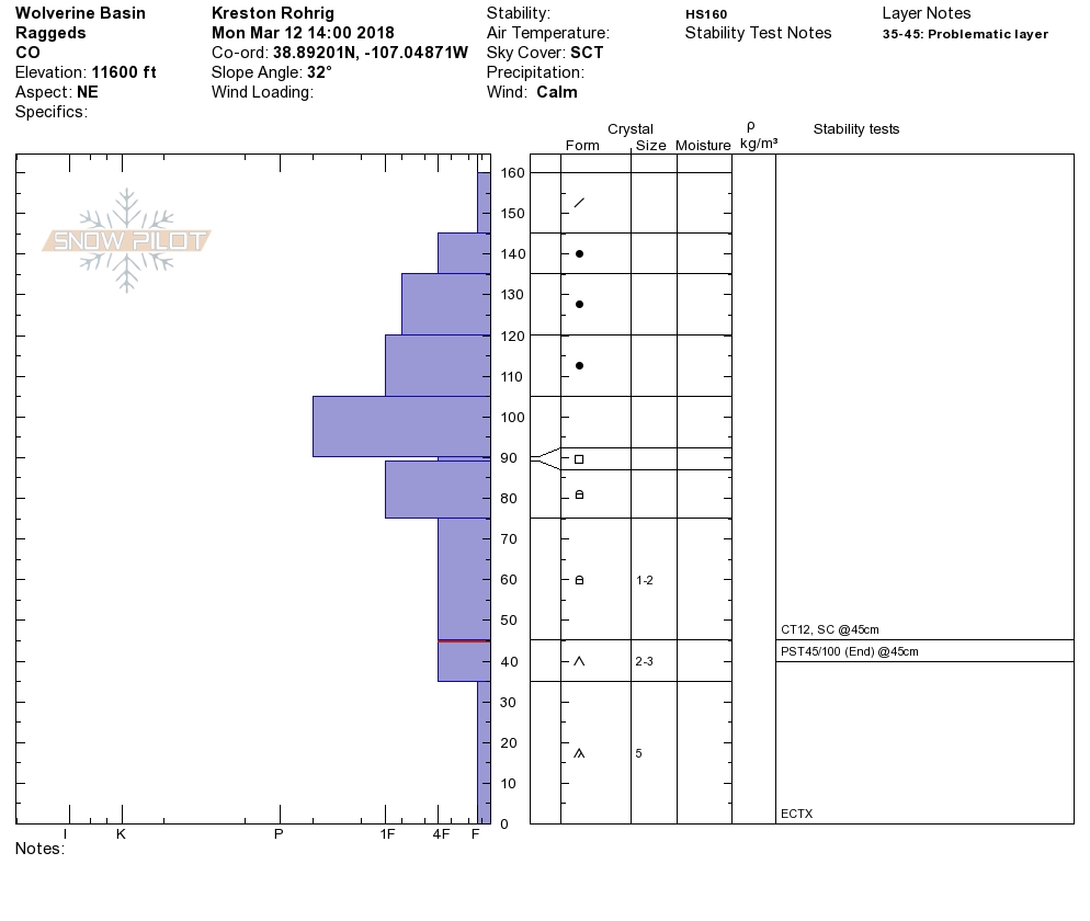
Snowpack: Below treeline, the snowpack is weak and faceted in most areas. It was easy to probe to the ground as HS ranged from 80-120cm. Any aspect not protected or facing directly north up to 11000'was cooking and wet. Later in the day as the surface cooled, crusts were starting to form. Pit profile attached at 11600' on a NE facing slope below the north ridge of Wolverine Basin. Mid and upper layer slabs are consolidating into a stiff structure that is insulating the weak facets and DH near the ground. Weak snow in this area is still 4F to fist hard, but becoming more difficult to initiate a failure. ECTX PST end 45/100 Above treeline the start zones in this area were mostly scoured out and thin. A few lingering wind slabs looked to have formed midway down the paths.

Photos: