Location: Crested Butte Area Date of Observation: 01/25/2017 Name: Mason Schmidt
Subject: Avalanche on Coney’s Aspect: East Elevation: Roughly… 10,100
Avalanches: D1.5, R1-2, broke on ~ 35 degree slope/ Tree Line/ Artificial Skier/ North East Aspect. Assuming it broke on 1/19 interface SH Weather: Overcast, Precipitation S-, Air temp -11 c, L NW Wind, L blowing snow on ridge tops, Snowpack: Surface temp -9 c,and 20 cm down -10 c. Surface Form was DF 1 mm, HST 20-30 cm (variable location), HS 265 cm,
Location: Crested Butte Area Date of Observation: 01/25/2017 Name: Zach Guy
Subject: Thin slabs in southern part of the zone Aspect: North East, East, South East, South West Elevation: 10,000-11,500
Avalanches: There were several recent natural slab avalanches that ran below easterly facing ridgelines near treeline, with long running debris D1 to D2 in size. We skier triggered a couple harmless 8″ soft slabs on east aspects near treeline; they appeared to fail on the SH layer. Weather: Cold temps. Moderate westerly winds with light snow transport. Broken to overcast skies, S-1. Snowpack: Traveled in the far southern part of our forecast area, which has gotten less snow out of these last few storms. Below treeline, there is about 8″ over the 1/19 surface hoar layer, which was relatively benign given the thin slab. Widespread, localized cracking on this layer, which we found on NE, E, and SE aspects, but not SW. Near treeline, we found drifts up to 40 cm, and propagating results on a mid-storm layer.
Location: Crested Butte Area Date of Observation: 01/24/2017 Name: Zach Guy
Subject: Touchy and dangerous surface hoar instabilities Aspect: North, North East, East, South East Elevation: 9000-11300 ft
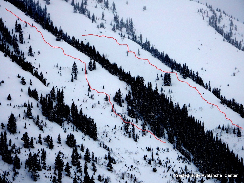
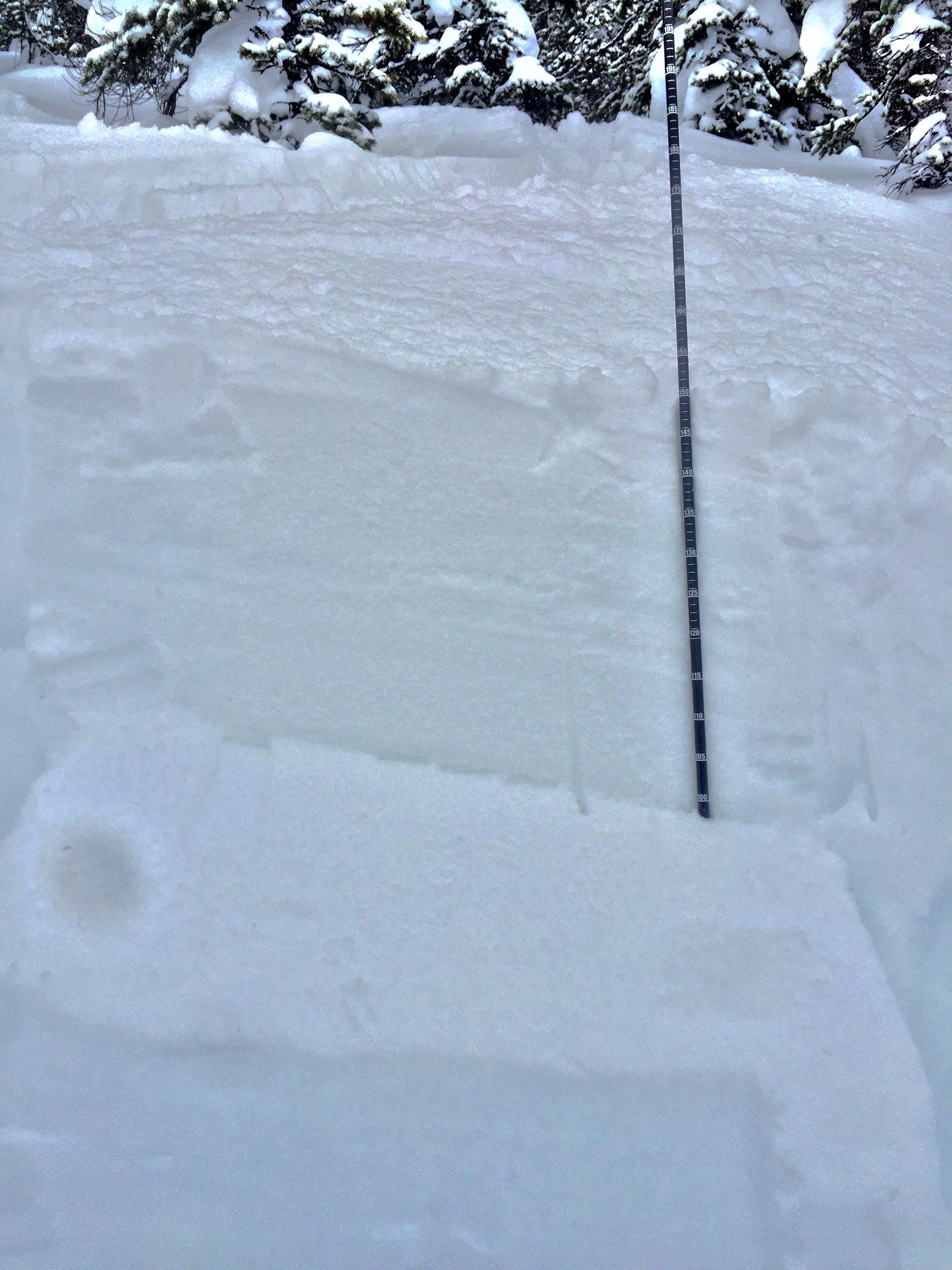
Avalanches: Widespread natural avalanches in the Happy and Climax Chutes running on the surface hoar layer, 14 -24″ deep. Most slabs were D1 to D2, R1 to R3, but in a few of the larger paths, wall-to-wall propagation and long vertical produced very destructive debris piles by valley bottom, reaching D2.5 or D3 in size. (SS-N-R4-D3-I). It appeared that about 50 to 75% of terrain flushed yesterday or overnight. Today, we remotely triggered two slabs from flat ridgeline and skier triggered another, failing on the same surface hoar layer. These were about 18-24″ deep on N/NE/E aspects NTL. One remotely triggered slide in the main Climax chute was initially ~100 feet wide but pulled in most of the bowl on its way down, over 1000 feet wide. SS-ASr-R4-D2.5-I. The others were narrower (R1/R2) and D2 in size. Weather: Broken clouds increased to overcast with S-1 to S2 in the afternoon. Light westerly winds with moderate gusts. Cold temps. Snowpack: Widespread surface hoar buried below a ~35 cm slab below treeline and up to 60 cm slab near treeline, still F to F+ hard. Touchiest snowpack I’ve traveled on all winter. Numerous small collapses below treeline on a gladed ridgeline, and widespread, large collapsing near treeline as glades became more sparse and slabs became thicker. A few shooting cracks observed. One crown profile on a NE aspect BTL showed hard, sudden collapse on the surface hoar in compression tests and no propagation in ECTs (I wonder if the layer already had collapsed above the crown, disrupting test results?). A profile on a SE aspect NTL showed multiple easy sudden collapse compression results and no propagation in ECT. (CT1, Q1 x 2), on the surface hoar layer above a thin crust.
Peanut Lake Road
Infrequent path near Lupine Trail. SE aspect.
Wide propagation, Climax Chutes
Destructive debris below Climax
Remotely triggered D2.5 or D3 in Climax Chutes. Wide propagation, ran full track.
Remotely triggered D2 in Climax Chutes.
D2 Natural in Climax Chutes
1/19 surface hoar layer the culprit in all slides observed today.
Location: Crested Butte Area Date of Observation: 01/24/2017 Name: Alex Banas, Donny Roth
Subject: Widespread buried surface hoar instability Aspect: North East, East Elevation: 10,800′
Avalanches: Intentional ski cuts produced the following:
Multiple SS ASc- R1-D1-I First bowl
Multiple SS-ASc-R2D2-I Second bowl
I think about 9 of these in total from first and second bowl. Some of these avalanched on slopes as low as 32*
We noticed one skier triggered D2 avalanche in 3rd bowl from yesterday. Weather: Scattered skies with calm winds in the morning transitioning to overcast skies with moderate down valley (gothic) winds in the PM. Snowing s-1 at 1130 transitioning to s3 at 1430. Air temps in the high teens getting colder in the afternoon. Snowpack: Touchy slab avalanches failing on the 1/19 surface hoar interface observed on the E-NE side of snodgrass today. All avalanches and shooting cracks failed 45-55cm down on the preserved surface hoar layer. This soft slab seems to be stiffening up throughout the day as shooting cracks increased in size and ski quality went down. The sensitivity to this instability is on the rise. This persistent weak layer is sitting above a bomber mid pack from our early january mega storm of 1f rounding facets. We did not notice any signs of blowing or drifted snow from the 1/23 wind event as we expected.
Location: Crested Butte Area Date of Observation: 01/24/2017 Name:
Subject: S**t sandwich Aspect: North East Elevation: btl
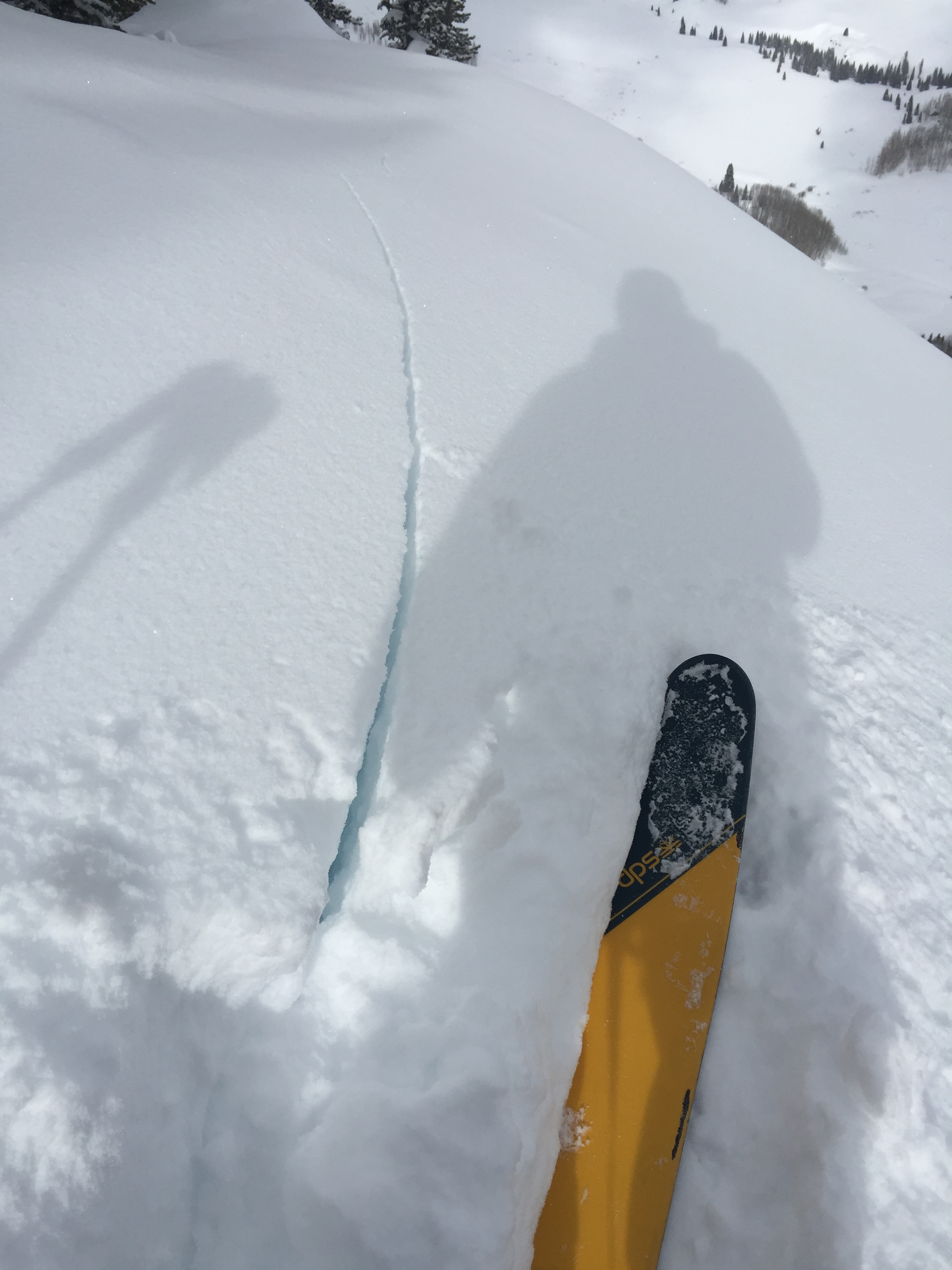
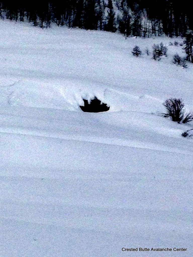
Avalanches: Visibility in and out, mostly out, but it appeared there was a natural on the far skiers left side of main Coney’s bowl that came off of that prominent rib but did not continue very far. Got one skier triggered pocket on lower roller 30-35 degrees at top of pocket (see photo) Weather: snowing, random breezes around 10 mph Snowpack: Right side up cake, upside down cake, I’ve never understood those so lets just call the top 16 inches a s**t sandwich with lighter snow on top of denser snow sitting on top of lighter snow, on top of a reactive layer.
Location: Crested Butte Area Date of Observation: 01/24/2017 Name: Zach Guy
Subject: Shallow avalanche cycle near town Aspect: North East, East, South East, South West Elevation: Below treeline
Avalanches: Widespread natural avalanche cycle below treeline yesterday or last night. D1’s to D2’s in size, crowns looked to be about 10″-14″ deep, and some very wide propagation, full path. Probably failed on 1/19 surface hoar. Most paths viewed were E or NE (Gibson Ridge, Peanut Road, Climax Chutes), but there were also a few on southerly. Looked at one roadside crown on a SW aspect and it failed on SH above a crust. Also a D2 in Coon Bowl (SE)and D1.5ish crown in Red Lady Bowl (SE). Weather: Snowpack:
D1 Peanut Lake Road
D1.5 Peanut Lake Road
D1 Peanut Lake Road
D2 Peanut Lake Road
D1.5 Peanut Lake Road
D1.5 Peanut Lake Road
D1.5 Peanut Lake Road
D2 Gibson Ridge. Wide propagation
D1.5 or D2. Gibson Ridge
D1.5 Peanut Lake Road
Several D2 to D2.5’s Climax Chutes. Very wide propagation
Location: Crested Butte Area Date of Observation: 01/24/2017 Name: billy barr
Subject: Gothic 5:30 Aspect: Elevation:
Avalanches: Weather: There was 4″ new snow between 7 and 11 a.m. yesterday, then very strong wind and little snow the rest of the day but substantial drifting. Wind kept up until near midnight but with no new snow until around 5 a.m. The 22 hour total is 4½” of new snow with 0.44″ of water as wind driven snow was dense. Snowpack at 84½”. Currently light snow and obscured (what else?) cloud cover. Cooled to 2ºF but now up to 7. billy Snowpack:
Location: Kebler Pass Area Date of Observation: 01/23/2017 Name: Irwin Guides
Subject: Holy Wind Batman! Aspect: East, South, West Elevation: 10,000 -12.000 ft.
Avalanches: Shallow storm slabs touchy first thing and then stiffened and became more wind pressed & stubborn. Weather: Major wind event today ravaged our terrain and made marginal ski quality, especially compared to the last few days! 5-hours (10:00-15:00) of 60mph winds and gusts in the 100’s. High gust of 111mph at 14:00. Snowpack: Storm board: 12″ (1.7″ SWE)
Location: Crested Butte Area Date of Observation: 01/23/2017 Name: billy barr
Subject: Gothic 7 a.m. report Aspect: Elevation:
Avalanches: Weather: Obscured clouds with light to moderate snow overnight with 6″ new and 0.42″ of water. No wind and snowpack is up to 84 1/2″ on the ground. yesterdays high only 23 despite some sun, while morning low today was 13F but up to 19 currently. And snow continues. Snowpack:


 W
W W
W B
B