Skier caught and carried in a wind slab

CB Avalanche Center2016-17 Observations, Avi-map 16-17

Location: Crested Butte Area
Date of Observation: 02/21/2017
Name: Zach Guy and Ian Hoyer
Subject: Skier caught and carried in a wind slab
Aspect: North East, East, South East, South
Elevation: 9000-12000 ft

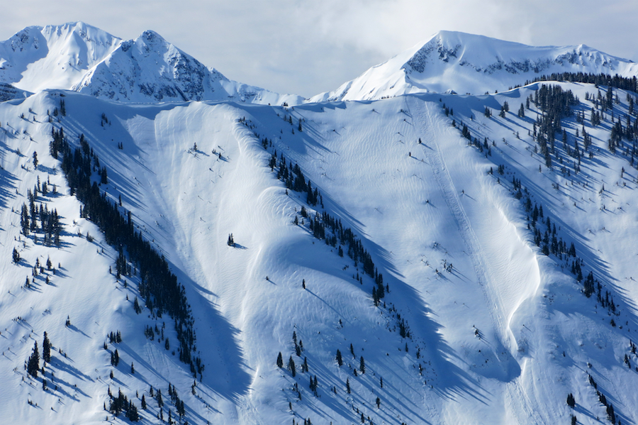
Avalanches: Observed an unintentional skier triggered wind slab on an E/NE aspect at 12,000 ft, above treeline. The slide broke a few feet above the skier and carried them about 700 vertical feet, resulting in a partial burial, several leg injuries, and a lost ski. The slab ranged from ~5 – 15″ thick, and broke on the 2/17 near surface facet layer. The slide was about 250 feet wide. HS-ASu-R1-D2-I
Weather: Broken skies in the a.m., decreased to thin scattered mid-day, increased to overcast in the p.m. Moderate WSW winds, no transport except some plumes on high peaks. Warm temps, green-housing. No precip.
Snowpack: On S/SE aspects N/BTL. The recent snow (1″-2″) is wetting and conforming to underlying crust layer. No signs of instability.
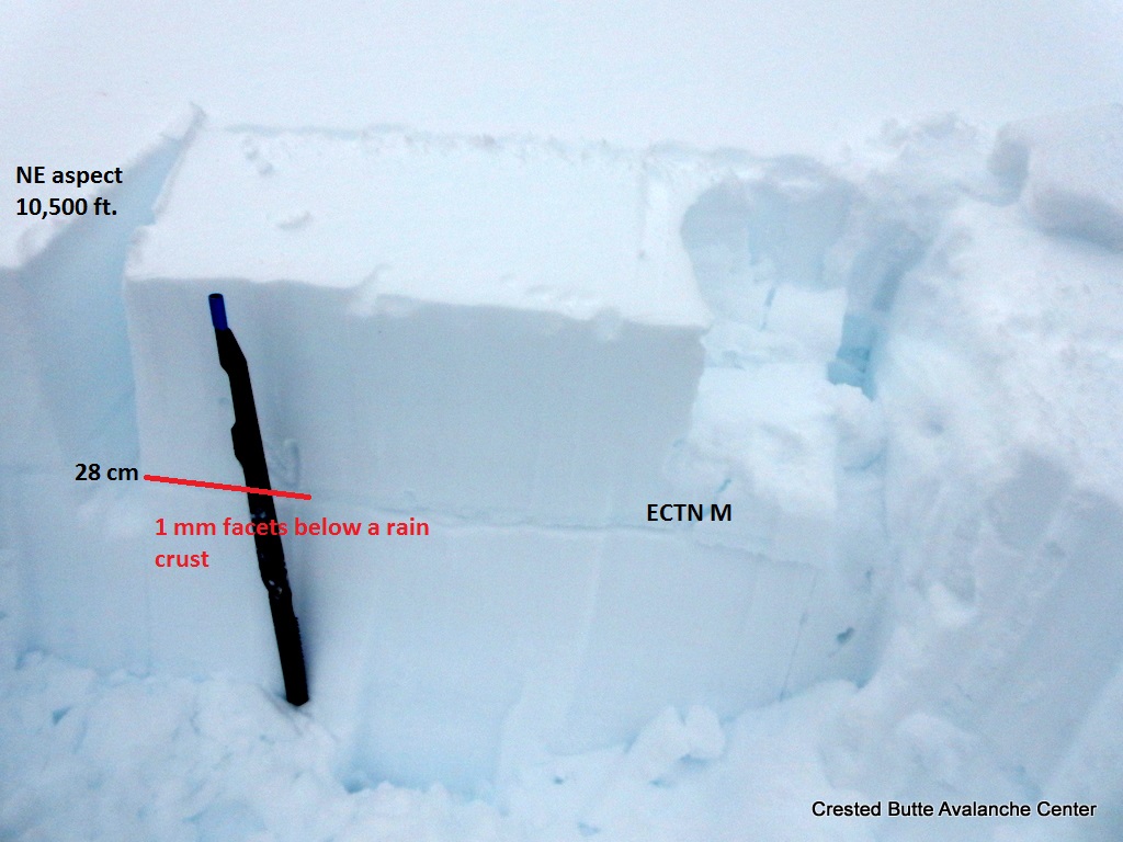
On a wind protected NE aspect NTL. A profile showed the 2/17 near surface facet layer (.5- 1mm) buried 8 cm deep. The 1/19 surface hoar layer was 85 cm deep, intertwined with rounded grains. Broken fracture on this layer with very hard additional loading steps. No signs of instability until we got to low elevation, northerly aspects, where we got some rollerballs in the moistening surface snow.
Near and above treeline, there were signs of wind drifting from both NW and SW loading patterns.

Crown ranged from 5-15″ in depth. The avalanche broke on recently buried near surface facets

The slope was a recently wind-loaded NE aspect above treeline in Coon Basin

The skier was partially buried in debris after being carried about 700 vertical feet.
Looking across the crown, which thinned down to ~5″. Slide broke around 250 ft wide.
Profile in Climax Chutes showed unreactive surface hoar layer 3 feet deep, and a fragile layer of facets near the surface.

Skier Triggered Windslab

CB Avalanche Center2016-17 Observations

Location: Kebler Pass Area
Date of Observation: 02/21/2017
Name: JD
Subject: Skier Triggered Windslab
Aspect: North East
Elevation: 12,500

Avalanches: Skier trigger windslab in 40+ degree couloir above tree line. 8″-12″ deep, 15′ feet wide. Cleaned out the middle of the couloir but left small slabs (hangfire) on the sides intact. Just exciting enough for the skier that triggered it.

Weather: Partly Sunny, broken, before noon, Overcast in the pm

Snowpack:

IMG_3853
IMG_3852

Mt. Emmons

CB Avalanche Center2016-17 Observations

Location: Crested Butte Area
Date of Observation: 02/21/2017
Name: Donny
Subject: Mt. Emmons
Aspect: North, South
Elevation: 9,200-12,200

Avalanches: No signs of instabilities were observed.
Weather: Partly cloudy throughout the day, no new snow, periods of strong radiation. Light to moderate NW winds at ridge top.
Snowpack: Sun-effected snow was settling quickly. HN24 ranged from 2” below 10,000’ to about 10” in the alpine. Ski Pen ranged from 1” to 12”. New snow seemed to bond to the old snow well and the old facets were still present. It wasn’t dust-on-crust as I expected. Snow on shady aspects was deep and soft – up to 12” and fist hard.

Wind slabs

CB Avalanche Center2016-17 Observations

Location: Crested Butte Area
Date of Observation: 02/20/2017
Name: Evan Ross, Chris Martin
Subject: Windslabs
Aspect: North East
Elevation: 9,600ft-10,800ft

Avalanches: Small windslab NE aspect Schuylkill Ridge. Small windslab E aspect above Purple Palace. Large windslab E aspect Purple Mountain.
BTL wide propagating slab N aspect Mount Emmons.
Weather: Partly cloudy. Calm winds.
Snowpack: At ridgeline windslabs were about 20cm’s deep over SH and well developed NSF. These slabs were confined to right at the rigeline and small in size. Below ridgeline the slab thinned until it was the last 24 hours of new snow at about 6-8cm. Digging around at 10,200ft and lower, the new snow was only over well developed NSF without the SH. The new snow below 10,200 was becoming heavy from warm temps and sun.

Small windslab NE aspect Schuylkill Ridge

IMG_2927

Small windslab E aspect above Purple Palace. Large windslab E aspect Purple Mountain.

IMG_2926

Wide propagating slab N aspect Mount Emmons.

IMG_2925

Touchy, small wind slabs

CB Avalanche Center2016-17 Observations

Location: Crested Butte Area
Date of Observation: 02/20/2017
Name: Zach Guy
Subject: Touchy, small wind slabs
Aspect: North, North East, East, South East, North West
Elevation: 9,000 – 12,500 ft

Avalanches: Skier triggered 5 or 6 shallow wind slabs, breaking on buried near surface facets, 6-18″ deep. All D1 in size. There were a couple of natural D1 wind slabs as well. These were all above treeline on leeward or crossloaded features. See photos.
Weather: Scattered skies. Light to moderate westerly winds, with short periods of light snow transport at ridgeline. Mild temps.
Snowpack: About 3″ of new snow, drifts from 6 – 18″ thick below ridgelines and in crossloaded features, mostly above treeline but a few near treeline slopes as well. The new snow is over .5 to 1mm reactive near surface facets, found at all elevations on northerly aspects, and on thick, meltfreeze crusts on southerly aspects. On east aspects N/ATL, the storm interface was a thin, collapsible crust with facets below or just facets. There was not enough new snow for storm instabilities except where it was thickened from wind drifting. We primarily traveled on northerly aspects and found shallow wind drifts to be poorly bonded on the 2/17 near surface facet layer.

Collapsible crust on an E aspect NTL, with facets below.

Cracking in a 12″ wind drift over buried near surface facets, NTL.

Natural D1 wind slab. E aspect ATL

Skier triggered D1 wind slab, NW aspect ATL. Broke on buried facets.

D1 wind slab, SE aspect ATL.

Shooting cracks, ~30 feet long, on E aspect ATL; wind drift over facets.

Skier triggered D1 wind slab, N aspect ATL. Broke on buried facets.

20″ wind slab at Irwin

CB Avalanche Center2016-17 Observations

Location: Kebler Pass Area
Date of Observation: 02/20/2017
Name: Irwin Guides
Subject: 20″ wind slab at Irwin
Aspect: East
Elevation: 11800 ft

Avalanches: 1 decent windslab triggered in Bender (East, 11,800′, 38 degrees) under foot. SS-ASc-R1-D1.5-I Triggered while walking across the edge of the ridge. 50cm deep, 50′ wide ran 400′ on the February 19 smooth crust. Several small dry loose and wet loose.
Weather:
Snowpack: 10″ with .9 SWE.

unnamed-3
unnamed-2

Wind Slab Avalanche

CB Avalanche Center2016-17 Observations

Location: Kebler Pass Area
Date of Observation: 02/20/2017
Name:
Subject: Wind Slab Avalanche
Aspect: North
Elevation: 11,800

Avalanches: SS-ASr-R2-D2-I. A Group of four skiers to our left, remotely triggered a slide from about ~100′ away. Slide was triggered from ridge top. Slide propagated within a large wind roll, proceeded to run ~1,500′.
Weather: Sunny, light winds out of the west.
Snowpack: No obvious signs of instabilities on the hike up. Noticed some point releases that had run yesterday, all start zones were from under cliff bands.

The slide was triggered from where the 2 skiers are standing in this photo.

Blue Bird

CB Avalanche Center2016-17 Observations

Location: Cement Creek Area
Date of Observation: 02/20/2017
Name: ADB
Subject: Blue Bird
Aspect: North, North East, East
Elevation: BTL

Avalanches: Nada.
Weather: Few clouds within the area and calm.
Snowpack: Between 2 to 5 inches of snow/24 hours. Lower 900 feet had 2 inches on top of rain crust from Friday.

Less than 2cm surface hoar already forming.

Emmons

CB Avalanche Center2016-17 Observations

Location: Kebler Pass Area
Date of Observation: 02/19/2017
Name: Will Nunez
Subject: Emmons
Aspect: North, South, West
Elevation: 9,300-12,300

Avalanches:
Weather: Brocken to increasing clouds with light to moderate winds out of the W-SW. Southerly slopes received strong solar with temps in the mid 30F. Light snowfall started around 1300 and increased to S1 to S2 with 2-3” new snow through out the afternoon by 1530.
Snowpack: No signs of instability of any instability where observed. The new snow that started at 1300 produced some fast moving sluffs on steeper NW slopes. A quick pit on a NW aspect shows F 4F 1F P HS 270cm Compression test had no results. The buried SH was found at 184cm the buried SH was unreactive and starting to round; it was also hard to separate the interface. Small to large sluffs were observed on S-SW- E slopes. Evidence cornice falls on E aspects were also observed.

West Brush Obs

CB Avalanche Center2016-17 Observations

Location: Brush Creek Area
Date of Observation: 02/19/2017
Name: Zach Guy
Subject: West Brush Obs
Aspect: North East, East, South East, South, South West
Elevation: 9,000-13,000 ft.

Avalanches: No new avalanches. Some cracking/storm slabs 2″ thick on the 2/17 near surface facet layer on NE aspects NTL; completely harmless but an indicator of how fragile that layer is right now.
See photos of older avalanches that ran during last storm or during the warm-up. Glide avalanches, persistent slabs, wet loose, and wet slabs.
Weather: Scattered clouds increased to overcast by late morning; S1 to S3 began around 12:30 p.m, about 2″ accumulation by late afternoon. Light SW winds with light snow transport at ridgeline. Mild temps.
Snowpack: Thick, supportive, frozen crusts on southerly slopes and no avalanche concerns on these aspects. Dry snow still on northerly aspects. The freshly buried 2/17 near surface facet layer was more pronounced/widespread on northerly near and below treeline slopes. Wind battered ATL here.  Didn’t see obvious signs of facets around the crusts on southerly slopes, except where the crusts were thin on low angle slopes. 3 pits on northeast aspects were as follows:
1) 10,500 ft. Thin melt-freeze crust about a foot deep, with 1mm facets below. Not reactive under current load (ECTN M) but something to keep an eye on.  Near surface facets 1″ deep.
2). 10,700 ft. 1/19 Surface hoar layer was 90 cm deep under a 1F slab. Propagating results in ECT with 4 additional shoulder hits beyond normal loading steps (ECTP 34, SC).  Near surface facets 2″ deep.
3.) 12,900 ft. A layer of small grained, well bonded facets was buried 45 cm deep. No fractures in a CT on any layers

Some recent and older glide avalanches. Easterly aspects BTL.

Some recent and older glide avalanches. Easterly aspects BTL.

D2. NE aspect N/BTL (10,700 ft). Looks like a natural from last storm, likely the buried SH layer but could have been a shallower weak layer.

Lots of wet loose activity on E, S, W aspects, averaging D1.5. This was a D2 Wet slab on S ATL, ran sometime during the warmup.

Several D1.5 and D2s on NE aspect NTL (10,700 ft and above). Looks like they ran last storm on the 1/19 SH layer, but could have been a shallower weak layer.

D2 on NE aspect N/BTL (10,700 ft). Looks like it ran last storm on the 1/19 SH layer, but could have been a shallower weak layer.

Buried rain crust/facet layer. NE aspect 10,500 ft.

Cracking and very shallow storm slabs on 2/17 NSF layer. NE aspect NTL

3 foot dense slab over propagating SH layer. NE aspect 10700 ft.