

Shaded aspects getting weaker

CB Avalanche Center2014-15 Observations

Name: Zach Guy
Title: Shaded aspects getting weaker
Location: Crested Butte Area
Date of Observation: 12/06/2014
Aspect: North, South
Elevation: 12,000 – 9,000 ft

Avalanches: Only minor sluffing on steep terrain, but we are heading towards facet sluffs pretty soon.

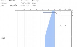
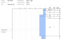
Snowpack: Toured up Red Lady skin track into Redwell Basin. On South aspects Near & Below Treeline, the snowpack is almost entirely facets with a couple melt-freeze crust layers near the surface of varying thickness depending on slope angle.

On North aspects: Above treeline was variable depth and density. The surface was grabby wind crusts, with faceted snow below and/or above. Near and below treeline is all faceting, in the 4F range, 1-1.5 mm in size. Snowdepth around 30-50 cm. Trapdoor skiing below 11,000 feet, with ski pen frequently to the ground.

A few patches of surface hoar, mostly in low elevation creek drainages or sheltered southerly aspects near treeline. See photo.

Surface hoar on Red Lady, near treeline.
December, 7 2014

CB Avalanche CenterWeather

Date: 12/07/2014

Lingering high clouds will continue today as we wait for a small disturbance to move out of northern Colorado. A ridge of high pressure will be moving into our area tonight leading to dryer weather on Monday. The fallowing work week will see continued mostly dry weather and above average temperatures. Late next week is a bit far out to trust weather forecasts, but they are currently suggesting a change in the weather pattern. So we’ll just put all our eggs in that basket and say bring on some change!

Weather Forecast for Saturday, December 6th

CB Avalanche CenterWeather

Date: 12/06/2014

A fast moving, disorganized system with a great deal of moisture will track across our area this afternoon and evening, dropping a quick hit of wet snow before moving eastward. On Sunday, and into early next week, the building high pressure will not shut out all moisture, allowing little scraps of sheared Pacific energy to cause a stray flurry and bring increased cloudiness at times across our area mountains. Late next week, the jet stream pushing potent winter storms into the Pacific Northwest looks to nose farther inland and could bring snow to our area.

Weather Forecast for Friday, December 5th

CB Avalanche CenterWeather

Date: 12/05/2014

After seeing mid level moisture 200% of normal for the past several days, the Elk mountains should dry out today, and feel less like the Pacific Nortwest as weak ridging takes hold, and allows some sunshine and blue skies. Look for clouds to decrease this morning, with temperatures remaining mild and winds generally light.

On Saturday, its possible the higher elevations will see light snow develop after sunset, but nothing to call in sick for. Maybe a few inches if we are lucky, but the meager rations will continue, before high pressure and temperatures 5-10 degrees above normal take hold into next week. Woof.

Irwin 12/3/14

CB Avalanche Center2014-15 Observations

Name: Zach Guy
Title: Irwin 12/3/14
Location: Kebler Pass Area
Date of Observation: 12/03/2014
Aspect: West
Elevation: Near treeline

Avalanches: 8 airblasts, 2 handshots on several previously untouched West facing paths N/ATL produced no significant results. One soft slab 5” deep, 20 ft wide, running on the Nov 22 facet layer in OL. SS-AB-R1-D1-O

Weather: Brief periods of S-1. Trace accumulation.

Snowpack: On west facing aspects near treeline: Snowdepths 70-120 cm deep. Mostly faceting midpack across slopes, some isolated slabbier feeling areas particularly behind tree fences. Nov 22 facet layer is 6-12” deep, appeared to be more preserved behind shading trees. Varying CT results, No ECT results on this layer. Nov 2 depth hoar layer is moist, rounding. No results on this layer. Several layers of melt-freeze crust and rime crust near the surface, with some rounding facets in between.

December 4, 2014

CB Avalanche CenterWeather

Date: 12/04/2014

Another tropical disturbance originating near Baja will be surging to our south. The San Juans will catch the brunt of this one, and our Elk Mountains will be lucky to pick up a few inches of wet snow. A ridge builds over the Great Basin on Friday, shifting the flow to the northwest under a drying atmosphere. The next Pacific trough arrives this weekend. Stay tuned.

December 4, 2014

CB Avalanche CenterWeather

Date: 12/04/2014

Another tropical disturbance originating near Baja will be surging to our south. The San Juans will catch the brunt of this one, and our Elk Mountains will be lucky to pick up a few inches of wet snow. A ridge builds over the Great Basin on Friday, shifting the flow to the northwest under a drying atmosphere. The next Pacific trough arrives this weekend. Stay tuned.

December 3, 2014

CB Avalanche CenterWeather

Date: 12/03/2014

A conveyor belt of tropical moisture is streaming over Colorado under southwest flow. Despite high moisture amounts, some other ingredients needed for big snowfall amounts are lacking. The first pulse of moisture is passing overhead early this morning uneventfully. The next push is crossing Southern Utah and Arizona early this morning and looks to be a better snowfall producer. We should see light snowfall by midday as it moves into the Elk Mountains, with a few inches of accumulation, potentially more at the highest elevations. The next wave looks to arrive Thursday evening, bringing another round of snowfall before clearing on Friday.

December 2, 2014

CB Avalanche CenterWeather

Date: 12/02/2014

A warm, moist Pacific system is moving onshore this morning. We’ll see clouds thickening and lowering through the day ahead of it. Although the system is packing unusually high amounts of moisture, mountain snow accumulations are forecasted to be relatively low because atmospheric lift is hurting. Moisture will continue advecting over the Elk Mountains through the week, bring continued pulses of snow.

December 1, 2014

CB Avalanche CenterWeather

Date: 12/01/2014

Weather Summary: A weak disturbance over our area will finish up snowfall this morning as it moves off to our east. Skys will be clearing throughout the day as we move back into more mostly clear and warm weather for Tuesday. Wednesday, a warm and moist system will move into our area on Southwest flow. More aspects of this system need to line up before we can accurately estimate snowfall but around 3-5” by Thursday for our mountains would be a start.