Snodgrass

CB Avalanche Center2014-15 Observations

Name: Matt
Title: Snodgrass
Location: Crested Butte Area
Date of Observation: 12/19/2014
Aspect: North, North East
Elevation: 10,800

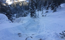
Avalanches: Significant sloughing of surface snow upon ski cuts in sparsely vegetated and steep gullies. Initial slough affected the surface layer, but ran to ground quickly and carried facet layer with it. Debris carried approximately 300 feet.

Weather: Clear skies, ~25-30ºF, none/light wind

Snowpack: Snowpack differed greatly between vegetated areas and open gullies.

In gullies, approximately 6″ inches of fresh powder above ~5″ of facets to the ground. Very little consolidation between layers, but did observe some cracking in surface layer on boot penetration.

Within trees, approximately 6″ of fresh powder above breakable crust (ski pen. 6″, boot pen. 2′). Knee-deep post-holing through crust while hiking back to road after deciding not to ski.

Uploads:

Axtell

CB Avalanche Center2014-15 Observations

Name: Travis Colbert
Title: Axtell
Location: Kebler Pass Area
Date of Observation: 12/19/2014
Aspect: North East
Elevation: 11,000-11,500

Avalanches: New snow is not bonding to the rotten snow from Thanksgiving. Fresh snow running readily on steep slopes, picking up momentum and gouging into the facetted base. First turns into half bowl produced a soft slide with a 10-12 inch mini-crown that ran for 100+ feet. Bailed and skied the lower angle trees near the skin track. Natural slide through the Pencil and lots of other releases observed in 1st and 2nd bowls.

Weather: Intermittent light snow. 10-15 degrees.

Snowpack: 8-10 inches of new snow over the past couple of days. 2-3 inches of fresh on the skin track. Light and unconsolidated snow on top of facets.

Mountain Weather December 19th, 2014

CB Avalanche CenterWeather

Date: 12/19/2014

Scattered snow showers across the higher elevations will slowly taper off during the day as a weak ridge of high pressure temporarily builds today. Winds should remain light and highs should reach the low to mid 20s today.

This ridge will quickly be ushered out of Colorado as a developing winter storm takes aim on northern and central Colorado starting Saturday night, as moist northwest flow develops, with dynamics aided by strong upper jet support. A Winter Storm Watch has already been hoisted, and models this morning are hinting at total storm accumulations to be measured in feet, and accompanied by more wind than what we have seen over the last few weeks. Looking ahead, another storm looks to clip the Elk Mountains just in time for Rudolph.

Snodgrass Snow Study Plot

CB Avalanche Center2014-15 Observations

Name: Nick Schley
Title: Snodgrass Snow Study Plot
Location: Kebler Pass Area
Date of Observation: 12/18/2014
Aspect: North East
Elevation: 9,500

Uploads:

Kebler Pass Area

CB Avalanche Center2014-15 Observations

Name: RR
Title: Skiing
Location: Kebler Pass Area
Date of Observation: 12/18/2014
Aspect: North, North East, North West
Elevation: 11,500

Avalanches: None observed, but some predictable pockets of power were popping out in steeper trees where there were rollovers. This big round of new snow seems quite tender. It was unconsolidated, so a little surface sloughing, but when the new layer slabs up, it could be interesting.

Don’t drive your sled into a creek.

Weather: Snowing (s1) with no to very light winds from the north.

Snowpack: 18 – 24″ of unconsolidated pow on top of a supportive crust or on top of more hollow snow.

Avalanche Incident Schuykill Ridge – Preliminary Info

CB Avalanche Center2014-15 Observations

Name: Zach Guy
Title: Avalanche Incident Schuykill Ridge
Location: Paradise Divide Area
Date of Observation: 12/18/2014
Aspect: North, North East
Elevation: NTL

Avalanches: We received a report of a skier triggered avalanche on Schuykill Ridge above the Slate River today. The skier was caught, carried, and injured. The victim was evacuated by helicopter to Gunnison, and is reportedly in stable condition. Our sincere condolences go out to the victim, family, and friends. The slide was reportedly triggered near the ridgeline on Schuykill Ridge, as the skier was dropping into a North or Northeast facing bowl near treeline. It broke an estimated 25-30′ wide, and several feet deep. The skier was carried approximately 150 to 200 feet before getting stopped by a tree, and the debris ran roughly 500 feet. A forecaster from the CBAC will be investigating the avalanche tomorrow, and we will post information as it becomes available.

Mountain Weather December 18th, 2014

CB Avalanche CenterWeather

Date: 12/18/2014

With plenty of moisture overhead, unsettled weather will continue today. Snowfall is winding down as most of the precipitation is shifting to our north and east this morning. Tomorrow brings a lull in the action as an upper level ridge brings partial clearing. Christmas might come early this year if Santa can drag the moist, northwest flow into our Elk Mountains this weekend. A series of waves bringing abundant moisture, favorable orographics, and jet stream support are forecasted to impact the northern half of the state beginning Sunday afternoon through Tuesday. Keep those fingers crossed it reaches us.

Purple Ridge

CB Avalanche Center2014-15 Observations

Name: Scott Krankkala
Title: Purple Ridge
Location: Paradise Divide Area
Date of Observation: 12/17/2014
Aspect: North East
Elevation: 12,300

Weather: Approximately 1in of low density snow fell overnight in the tour area. Light snow in the morning clearing around 9:30. Clouds returned with light snow around 1230. Winds were light from the northwest on ridgetops.

Snowpack: Little evidence of overnight wind transport. Yesterday’s tracks were not completely obscured, and little evidence of deposition from west winds was noted along the ridge. Snow immediately below ridge was still soft. Released one small shallow slab on a crossloaded feature although it failed to propagate more than 10ft. No other signs of instability were noted. Closer to the valley bottom the effect of temperature was evident as the surface snow became much more dense and cohesive.

Skiing

CB Avalanche Center2014-15 Observations

Name: Chad Reich
Title: Skiing
Location: Crested Butte Area
Date of Observation: 12/17/2014
Aspect: South East
Elevation: 12,400

Avalanches: Observed 2 slides that had already happened on Axtel’s north face below the Wang Chung face, but we couldn’t tell if they were natural or skier-triggered. They were each R1’s, but they would probably have been big enough to injure or kill a skier.

Weather: Lightly snowing (>s1), with strong and sustained winds on the upwards of 20 mph coming from the N. Despite the winds, no cross/lee loading was observed, but it was snowing….Temps were about 20 at the TH and 10 at the summit.

Snowpack: About 4-6″ of new, unconsolidated pow on top of a firm, supportable crust. No high speed sloughing observed on the way down.

Mountain Weather December 17, 2014

CB Avalanche CenterWeather

Date: 12/17/2014

A weakly organized system will spread snow showers into the Elk Mountains today. We’re looking at 3-6” by Thursday morning, before flow shifts northwest and a shortwave ridge dries out the atmosphere heading into the weekend. Models are hinting at the right ingredients for continued snowfall this weekend and Christmas week.