Mountain Weather December 23, 2014

CB Avalanche CenterWeather

Date: 12/23/2014

The jet stream that has been driving heavy snowfall and intense winds will weaken through the day and slowly shift east. Snowfall is forecasted to wind down to isolated flurries. A ridge builds to our west, issuing frigid and dry air this evening, perhaps our coldest temps this winter. The lull in action won’t last long, as a Pacific trough digs into the Great Basin Wednesday night, bringing significant snowfall to the Elk Mountains on Christmas.

Irwin Tenure

CBAC2014-15 Observations

For P.M. Forms
Day H2D/W HN24/W HST/W HS
Last Night 19 / 2.6 27 / 3.4 30 / 3.75 54
Today 5  / .4 5 / .4 34 / 4.15 57

West aspect NTL:  Long Shot: SS-AE-R3-D1.5- O/G: 60cm at deepest, 40’ wide, ran 400’. 3 different interfaces were seen in crown. See photos. Another slide in Way Long but could not see if it was slab or loose snow, put debris 400’ down.

West aspect NTL: SS- AEr-R3-D2- O. Triggered remotely from approximately 6 feet from a 4lb hand charge in Lean. Crown was 90cm deep (4F to 1F) on Dec 13th crust. 70’ wide, ran 500 feet to Round 2. Debris was 4-6 feet deep.

Gothic snow observation

CBAC2014-15 Observations

Strong, steady wind all night but with only light snow and staying quite mild. Past 24 hours has 5″ new snow and water 0.37″. Wind letting up slightly towards sunrise and snow picking up a bit.  No visibility, currently 22ºF.  Good snow transport from the wind.

-Billy Barr

Large Natural Above Nordic Center

CB Avalanche Center2014-15 Observations

Name: DH
Title: Large natural above Nordic Center
Location: Crested Butte Area
Date of Observation: 12/22/2014
Aspect: North, North East
Elevation: 9,000 ft

Avalanches: The hill above the Nordic Center just went big. Wall to wall as big as it could have gone and plenty big to bury a person. Pretty scary.

Uploads:

Crested Butte Zone

CB Avalanche Center2014-15 Observations

Name: Evan Ross
Title: Crested Butte Zone
Date of Observation: 12/22/2014
Aspect: North East, South East, South West
Elevation: 11,000

Weather: The word, Blizzerd, would sum this section up well. Strong westerly winds, snowing hard S2-S3, drifting snow, whiteout conditions at times in open areas. Sweet!

Snowpack: Toured midday in the Elkton area. Very touchy avalanche conditions on all aspects toured with a good chance to release an avalanche problem on any slope over 30 degrees. Storm snow was wildly variably in depth from strong to extreme westerly winds. The 12/13 crust interface was exposed in some areas or buried by 3 feet of F+ slab in others. Rumbling collapse where muffed by the recent slaby storm snow. These Rumbling collapses where remotely triggering soft slabs on all three aspects from long distances away. On SW and SE slopes these slabs where most active in specific terrain features that have seen additional wind loading. On these aspects the soft slabs appeared to be running on the 12/13th crust interface but may have initiated at a storm interface. On a NE aspect the problem was widespread and just as easy to remote trigger from large distances away. On this aspect, soft slabs where running on the 12/13 NSF interface. These slabs where measured at 21″ deep on one slope and were wildly propagating around, or through terrain features.

Avalanches: Several remotely triggered R1-D1 and R2-D1.5 soft slabs on SE and SW slopes greater then 30 degrees. One remotely triggered D2 soft slab avalanche that propagated wildly through terrain features and tree islands

Uploads:

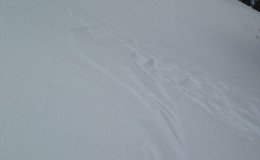
Thicker wind deposed soft slab on a SW aspect at 11,000ft

IMG_0060

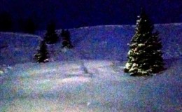
Hangfire above a wildly propagating persistent slab avalanche on a northeast aspect at 11,000ft.

IMG_0057

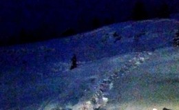
Remotely triggered soft slab on a southeast aspect at 11,000ft.

IMG_0051

Elkton

CB Avalanche Center2014-15 Observations

Name: Zach Guy
Title: Elkton
Location: Crested Butte Area
Date of Observation: 12/22/2014
Aspect: North, South
Elevation: 11,000 feet

Avalanches: We avoided avalanche terrain and had poor vis to view paths like Coney’s or Gothic. Some very small road-cut avalanches observed, failing on mid storm layers.

Weather: Spent yesterday and this morning at Elkton Hut. Constant snowfall all day yesterday and into this morning, S2 to S3 on average, with moderate to strong west winds. Whiteout conditions.

Snowpack: Heavy wind transport made for variable storm snow distribution across terrain, typically from 15″-24″ deep, some drifts easily 3ft deep. Very slabby, dense, and top heavy over lower density snow from last week, over the facets or crusts that formed early December. Some cracking observed on southerly aspects. Very wide running crack (over 300 feet wide) triggered when approaching a north facing slope.

Uploads:

Mountain Weather for Monday, December 22nd, 2014

CB Avalanche CenterWeather

Date: 12/22/2014

The strong pacific system with origins near Hawaii will continue to churn through Colorado today, dropping an additional 6-18″ by Tuesday morning. The strong overhead jet with dip closer to the lower levels of the atmosphere, generating vorticity and high winds at all elevations. Alpine terrain will likely see wind speeds in the 80-100 mph range and creating whiteout conditions. Winds will eventually switch to a more northerly direction this afternoon, which will cut off the moisture source, and gradually end the snowfall in most locations by the evening hours.

Red Lady Glades

CB Avalanche Center2014-15 Observations

Name: Mike Nolan
Title: Red Lady Glades
Location: Crested Butte Area
Date of Observation: 12/21/2014
Aspect: South East, South
Elevation: Treeline

Avalanches:

Weather: Steady snow and calm winds below treeline. Heavy gusts and rapid loading above tree line with whiteout conditions. 8-10″ new before 12:00

Snowpack: New snow is not bonding well to crust. Extensive shattering on anything above 30 degrees near and above treeline.

Uploads: