Name: Evan Ross
Location: Washington Gultch
Date of Observation: 12/20/2014
Aspect: North East, East, South
Elevation: 11,000
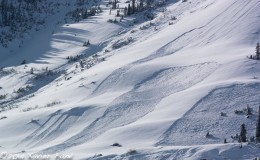
Avalanches: No recent avalanche activity noticed in the Washington Gulch area.
Weather: On and off S-1 to S1 through the mid-day. Overcast sky. Light NW winds not transporting snow around 1pm.
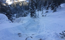
Snowpack: Lots of low density storm snow just waiting to be blown around by stronger winds.
Test profile on an East aspect just below ridge line (attached below). Storm snow on the 12/13 interface was F-F+ and this little bit of cohesion produced propagating results on NSF layer in stability tests. Storm snow on a North aspect at the same elevation and on a similar terrain feature lacked any cohesion and didn’t produce similar results on the same interface. If the storm snow had some cohesion or slab the results would likely have been the same on the widespread NFS layer between the different aspects. The big difference between these two slopes were in the bottom 10cm of facets. The North aspect held fist hard DH that produced SC results in compression tests. The bottom 10cm on the east aspect was 1 finger facets and produced no results in CT tests. Both slopes held about 80-90 HS.
The storm snow continued to show good bonding to 11/13 crusts on a South aspect.
Many BTL Southerly slopes in Washington gulch are still bare ground or hold a very shallow HS. In general, Washington Gulch seems to be holding a shallower HS then right next door in the Slate River drainage. As well as much less recent avalanche activity.
Uploads: